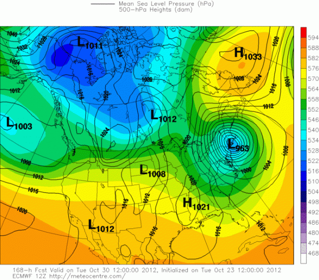
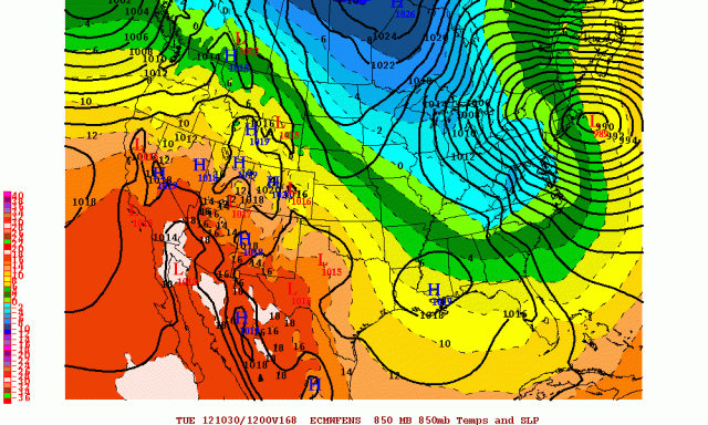
There she is, on the most recent run of the European model, the post-tropical remnants of Tropical Storm “Sandy” paying a visit to southern New England and the New York City area next Tuesday. As we slowly get closer to this possible storm, one must ask, might this actually happen? As I discussed yesterday, the models may still change into this weekend and it will be hard to lock in any kind of solution until at least Thursday or Friday. With that said, let’s break down some recent model data now:
Above are our now four major global models that see out into early next week. The models are labeled and valid for Sunday morning. Let’s break down some key features on the models:
- Sandy itself: Out of all the models at this timeframe, the Euro is the farthest southwest with Sandy, the GGEM, or Canadian model, is the farthest northeast. The GFS and UKMET are somewhere in the middle. The Euro is the only model that successfully hit the eastern US with Sandy later in the run, so where Sandy tracks over the next few days may be important.
- The Pacific Pattern and western US ridging: Out of all the models, the GFS, like yesterday, remains the flattest model with the least ridging in the western US and the flattest trough in the central US. However, it has trended closer to the other models, and the difference is not huge. The GGEM model is the sharpest model out west, as it generally has been. This is interesting, because the GGEM doesn’t show Sandy hitting the eastern US, this run. The Euro and UKMET are in between the two extremes. In general, the models have trended a bit FLATTER with the western US pattern since Sunday, however the GFS remains an outlier, and is trending the other direction.
- The Atlantic Pattern: At this point in the model runs, this feature is reasonably similar on all four models. The UKMET appears to be a bit weaker with the Greenland ridging than the rest of the models, however, the GFS and GGEM are weaker with the ridging stretching from eastern Canada towards the central Atlantic. This is key, because it allows these two models to take Sandy out to sea.
As we jump forward to Monday morning, let’s see what changes with the four main models.
- Sandy itself: The Euro is by far the farthest northwest with Sandy Monday morning. The GGEM and GFS are both far east, with the UKMET between the two extremes. The GGEM and GFS both fail to hit the eastern US with Sandy…the Euro ended up hitting southern New England and NYC with Sandy this run. The UKMET, if it ran out farther, would probably be out to sea, but may be close.
- Western US ridge and central US trough: The GFS remains the most progressive with the central US trough at this point. It is slightly deeper than the Euro’s depiction of the trough, but chugs it east faster. The UKMET and GGEM are both very deep and sharp with the trough, and would likely pull Sandy into the US IF Sandy wasn’t well out to sea by the time the trough approached the US east coast. The Euro is actually quite shallow with the trough, but because the blocking in the North Atlantic doesn’t let Sandy escape, the Euro still allows Sandy to be caught by the trough and pulled into the Northeast US. The Euro is also just slow enough with the trough that Sandy can get far enough north for a capture.
- The Atlantic Pattern: The Euro is the strongest with the blocking in the North Atlantic, the GFS the weakest. The Euro subsequently keeps Sandy closer to the coast than the rest of the models. The GGEM and UKMET are fairly strong with the block, but still manage to move Sandy east into the block. This seems suspect.
What do the ensembles say?
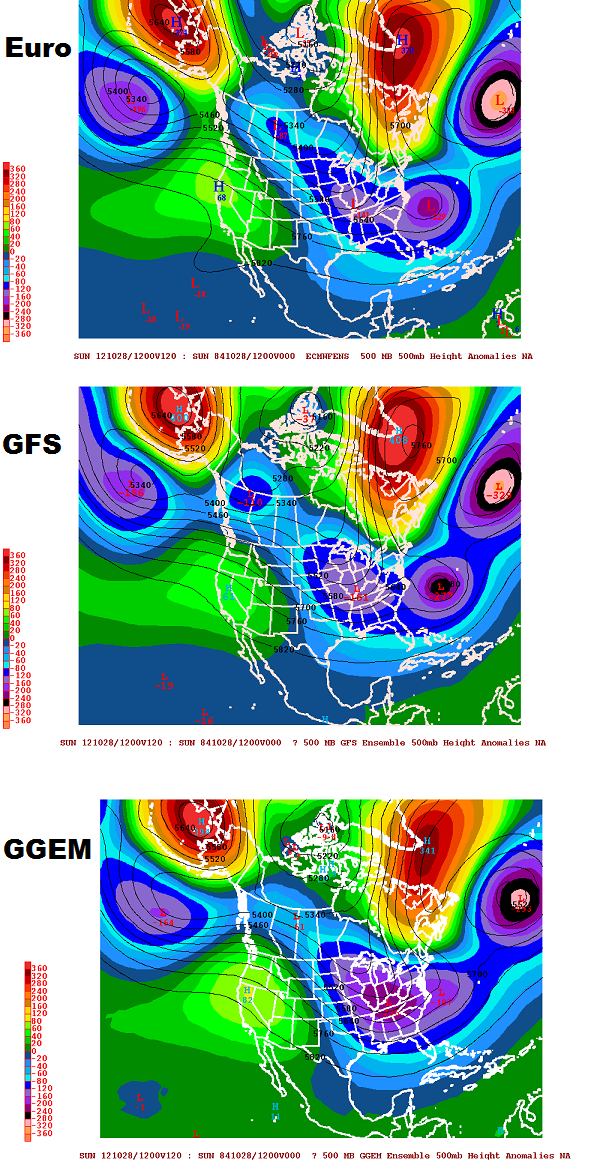
For the GFS, European, and Canadian (GGEM) models, each time the model runs, each country’s meteorological service runs the same model again 20-50 times with slightly different initial conditions. This allows for a blend of these solutions to possibly shed light on whether or not the operational versions of the models, discussed above, are out to lunch, or realistic.
-As we look at the North Atlantic, the GGEM ensembles, in general, are weaker with the blocking Sunday morning than the other two ensembles. This may indicate that the GGEM model’s fast speed with Sandy is an outlier.
-The GFS ensembles, when evened out, do not weaken the ocean low over the northeast Atlantic and allow Sandy to move right into it, unlike the operational model. This indicates that the operational GFS might not be accurately depicting how Sandy, the large ridge over Greenland, and the ocean low will interact.
-The GFS ensembles match the GFS with a flatter western US pattern…the GGEM ensembles match the operational GGEM with a more amplified western US ridge and central US trough. The Euro ensembles appear to match the operational Euro in showing a less amplified central US trough.
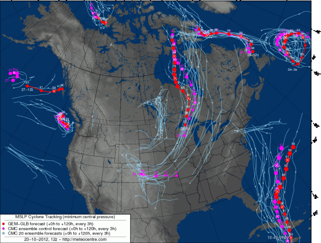
The GGEM ensembles, above, despite showing a weaker N. Atlantic block than the GFS/Euro ensembles, still manage to take Sandy closer to the US than the operational GGEM run. This is a red flag that the GGEM might trend back west in future runs.
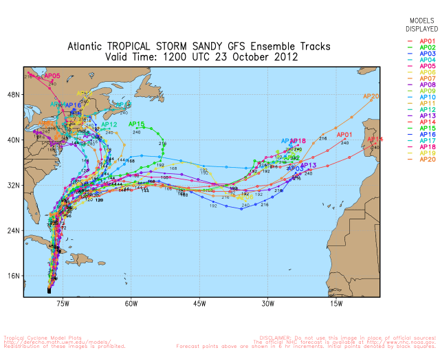
The GFS ensembles, above, are split in what they want to do with Sandy. 9/20 members take Sandy into the NE US, 10/20 members match the op GFS and take Sandy well out to sea, and 1 member appears to be heading back towards the US at the last second. This indicates the operational GFS, which does not handle the N. Atlantic ocean low like the other models, may be in error in weakening the ocean low and tracking Sandy well east.
The Euro ensembles are very similar to the op Euro, indicating a New England threat early next week.
So, what does this all boil down to? There are still differences in the models in how blocking over the N. Atlantic plays out, differences in where Sandy tracks, and differences in how the western US ridge and central US trough play out. So despite the signs that perhaps are trending more towards a threat to the Northeast from Sandy next Monday-Tuesday, until we get a better idea of how blocking will play out over the Atlantic over the next couple days, until we get Sandy north of Cuba in a couple days, and until the energy that will carve out the trough over the central US is sampled on Thursday, we cannot reasonably sound any alarms, as the models will remain prone to large shifts.
My advice to anyone living in the northeast US, or SE FL as a shift west may bring Sandy in that direction, is to continue to monitor things, but not to panic until the models settle down a little more as we head towards the weekend.



Good blog you have here.. It’s hard to find good quality writing like yours these days. I honestly appreciate individuals like you! Take care!!