
Not a surprise in a strong El Nino winter but December 2023 has been a very mild so far, with no significant cold anomalies expected in the continental U.S. (CONUS) the rest of the month to take much of the edge off of this map. While parts of the country have seen impactful winter weather, with Blizzard Warnings and Ice Storm Warnings posted across parts of the Plains and Upper Midwest as of this writing, it’s generally been a very slow start to winter across the Lower 48 and much of Canada. Current snow cover analysis reveals very limited snow cover across the CONUS at the end of December:

Outside of some of the highest elevations out west, the Plains where a winter storm is ongoing, and the highest elevations of Upstate NY and northern New England there is no snow cover in the Lower 48. Southern Canada isn’t in much better shape. Here is the departure from normal snow cover across the CONUS:

For the most part it’s been a slow start to winter across the U.S., especially across the northern U.S. where they should be reliably chilly and snow covered by now. In parts of the northern Rockies, Upper Midwest, Great Lakes and northern New England seasonal snowfall anomalies are getting larger by the day, and with higher snowfall averages it will be harder to catch up in these areas. This is especially true in a stronger El Nino winter when there’s inherently weaker polar jet influence, meaning fewer clippers and cold air masses that can set off lake effect snow. Farther south, where average snowfall is generally lower and where the enhanced El Nino sub-tropical jet stream could come into play if we see more cold air there’s still time to see seasonal snowfall catch up to or even exceed average.
The question is, will we see a transition to a colder pattern? Let’s start by establishing how the pattern has behaved, what is driving it, and how these pattern drivers are evolving right now. Behavior of the Pacific jet is a significant driver of our current pattern. How the Pacific jet evolves along with potential for high latitude blocking will determine much of how this goes…something that can probably be said most of the time in the winter months.

A significant influence on the Pacific jet stream is East Asian Mountain Torque (EAMT). Remember that big cold blast in Siberia earlier this month? The Arctic high associated with that dropped across eastern Asia (and is still doing so early in the above loop). This denser airmass and higher pressure east of the Himalayas puts a torque against the planet’s rotation, slowing it down an imperceptible amount. To conserve momentum, this is compensated for by speeding up the jet stream over the Pacific…promoting stormier conditions over the northern Pacific. The Rockies can have a similar affect on the jet stream over the north Atlantic.

Note how a strong positive EAMT event occurred over the last week or so as the aforementioned Siberian high dropped into eastern Asia. EAMT will generally trend more negative over the next 2-3 weeks, though it’s possible we see one last little push of +EAMT in the first few days of January which may be important to determining how quickly the Pacific jet retracts during the first half of January.
The strong +EAMT has led to the dramatic intensification of the north Pacific jet ongoing now, though the jet will begin retracting over the coming days and continue retracting/weakening into early January as EAMT trends more negative (and as tropical forcing changes, will get into that below). The stronger jet leads to stronger ageostrophic flow within its embedded jet streaks, encouraging a stormier (and amplified) pattern, especially near the eastern edge of the jet where the upper-level flow is most diffluent.
As the jet reached its easternmost extension over the last few days the stormy pattern was over the southwestern US with ridging amplifying northeast of that. As the jet begins retracting over the next several days the stormy pattern will shift west into the Pacific, allowing ridging to shift west towards the west coast and Alaska while continuing to amplify. This jet evolution has strongly contributed to our ongoing mild pattern and the change will contribute to a period of cooler conditions to start January.

Wanted to demonstrate how important the Pacific jet has been on the pattern we are seeing. Per the analysis, we went from a jet retraction in mid December to a recent poleward shift of the jet. The jet is expected to be more characteristic of the “jet extension” phase the rest of this month, before briefly moving towards either jet retraction or poleward shift, perhaps briefly passing through equatorward shift. My gut feeling is that we may see a jet retraction by the second week of January (before a chance for a poleward shift) due to the persistent -EAMT that is being modeled by then. Prior GFS runs also suggested a similar idea. Worth watching for that trend. Here is what these North Pacific Jet phases typically correlate to:
Poleward shift heights and resultant temperatures:
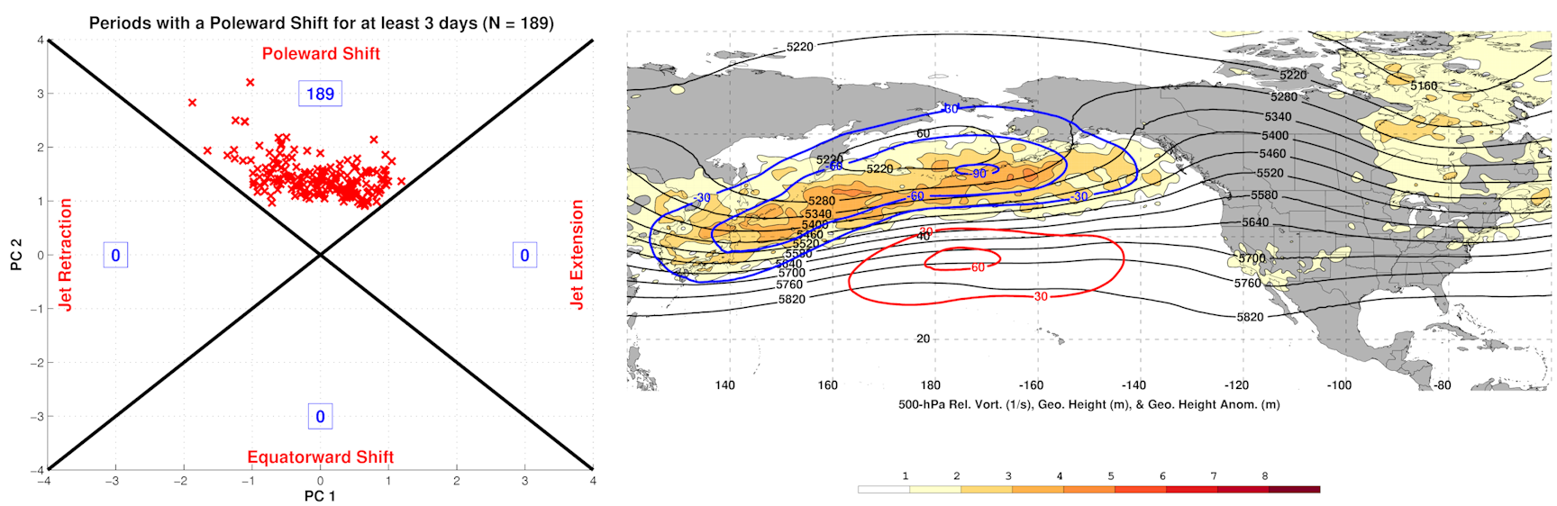
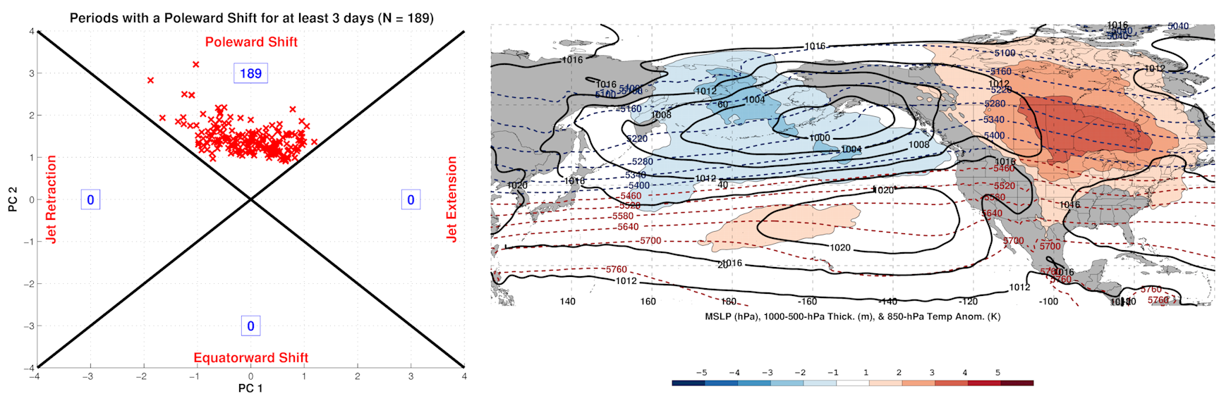
A very Pacific-dominated pattern with minimal polar/arctic influence and very mild conditions across a good portion of Canada and the northern CONUS. Very similar to what we’re currently seeing.
How about a jet extension, which is what we’ll see over the coming days?


Supports increasing heights along the West Coast and into Alaska, less Pacific influence, and at least some polar and arctic influence into North America, with cooler anomalies over parts of the eastern U.S. Looks a bit like the pattern showing up on the models and ensembles over the next week.
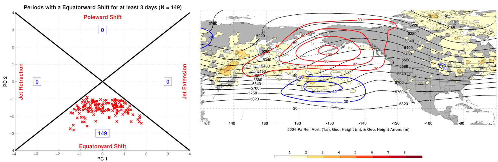
An equatorward shift is inherently hard to sustain in an El Nino but is most conducive to EPO-induced cold shots into southern Canada and the CONUS:

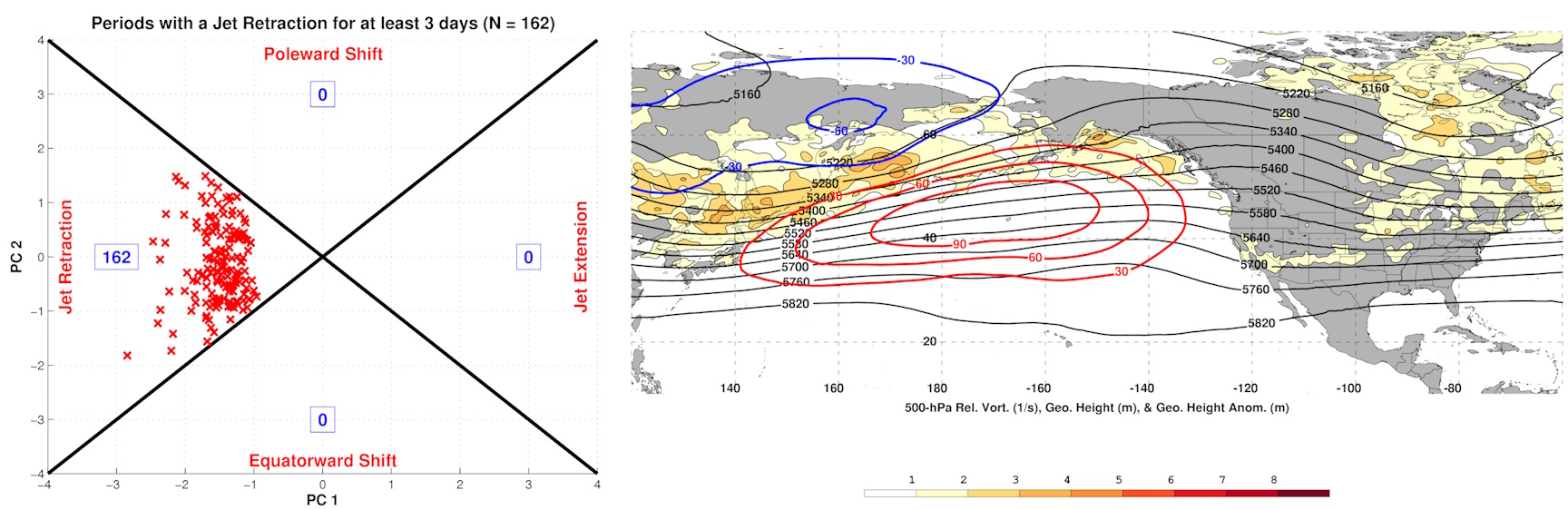
Jet retractions favor flatter ridging farther west over the North Pacific…a -PNA pattern, which is showing up in the extended ensembles…

How the Pacific jet plays out (how quickly it retracts) in early-mid January may be very important…the Pacific jet will be more favorable to a western North American ridge and eastern trough over the next 5-10 days, but how long that can last is in question. The East Asian Mountain Torque remaining positive for a longer period of time (i.e. high pressure persisting longer east of the Himalayas) could slow the onset of any -PNA pattern towards the second week of January.
Tropical forcing is also influencing the pattern…the MJO is making a fairly amplified pass through phases 1-2 through early January:

This supports amplification of western North American ridging and at least some semblance of a -NAO (Phase 1 top, Phase 2 bottom):

So far the East Asian Mountain torque and tropical forcing do a good job of explaining the evolution of the Pacific jet and the recent/upcoming North American pattern. The troposphere and stratosphere have seemed to be relatively well-coupled so far this season, with an amplified pattern in the troposphere in late November and early December leading to increased upward heat and wave fluxes into the stratosphere. This has led to an ongoing stratospheric warming event that appears poised to downwell into the troposphere.
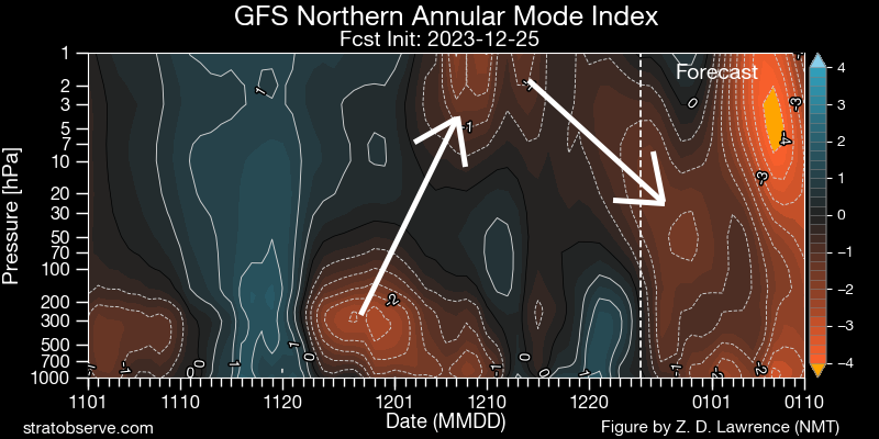
Not only do the mountain torque and tropical forcing support amplified ridging on the west coast into Alaska the rest of this month into early January, along with perhaps a -NAO, but the downwelling negative AO out of the stratosphere supports high-latitude blocking. Lots of factors supporting the pattern change that will be getting underway very soon.
Here’s a look at the EPS mean 500mb and surface temperature forecasts through the upcoming pattern change:
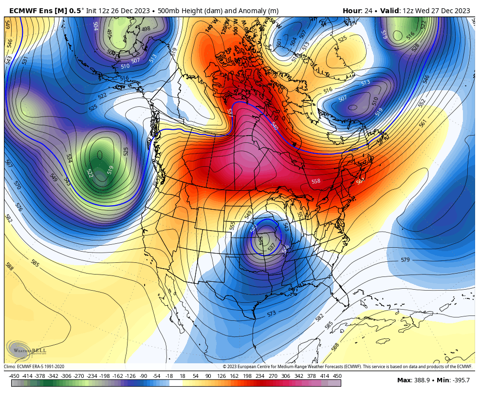
The 500mb evolution shown on the ensemble seems strongly supported by the various forcings described above over the next 10 days. The ongoing storm over the central U.S. starts carving out a trough over the eastern US over the next few days, with amplifying ridging on the west coast deepening the trough over the next 10 days as energy ejects out of the southwest U.S. in the subtropical jet. This leads to increased polar and arctic influence into Canada and the U.S., but the source region is currently very mild which will take time to completely overcome. The above loop suggests cross-polar flow into Canada, which would assist in cooling it off in early January. While the longwave trough axis is gradually shifting west (towards a -PNA/+EPO) at the end of the run, it’s worth noting that this isn’t happening quite as quickly as prior runs. That seems to be a source of uncertainty right now.

The result is a cooler trend over the CONUS, especially over the southern U.S. where the active subtropical jet keeps conditions more active. Over Canada it remains generally mild for the foreseeable future but certainly trends much less mild than recent conditions. By the second week of January, there is some potential for cold anomalies to begin overspread Canada if the idea of prolonged cross-polar flow verifies. It’s worth noting that this is a change from temperatures well above freezing all the way to Hudson Bay to sub-zero temperatures (on the ensemble mean) down to at least that latitude:

The tug of colder air behind the current Plains storm is very meager but the colder air becomes much more “tappable” by the beginning of January, so any storms that develop will be able to pull in seasonally cold air. Nothing crazy but certainly much more wintry feeling that at the moment. Note those frames are all 12z which catches something close to the daily lows.
While the tropical forcing, mountain torque/Pacific jet, and stratospheric influence support upcoming amplification of ridging along the West Coast into Alaska and perhaps a -NAO, there are some hints that a more -PNA/+EPO pattern (mild, Pacific dominated) may take hold by mid January. Is that legit?
Recall back to the SLP loop and the mountain torque discussion:
A sustained negative EAMT event appears likely in early January, supporting retraction of the Pacific jet (and a -PNA). However, there is some uncertainty regarding how quickly the Pacific jet retraction occurs. There is a hint of some transient +EAMT trends during the first week of January, which could help slow the retraction of the Pacific jet and subsequent -PNA development.
Also, note how a similar evolution (about a week later) of Rocky Mountain Torque (RMT) supports ridging over the North Atlantic, as a +RMT and strong North Atlantic jet to start January gives way to a -RMT and weakened North Atlantic jet by the second week of the month.
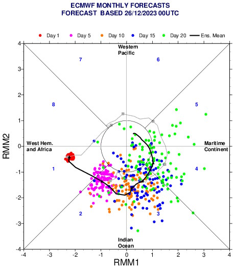
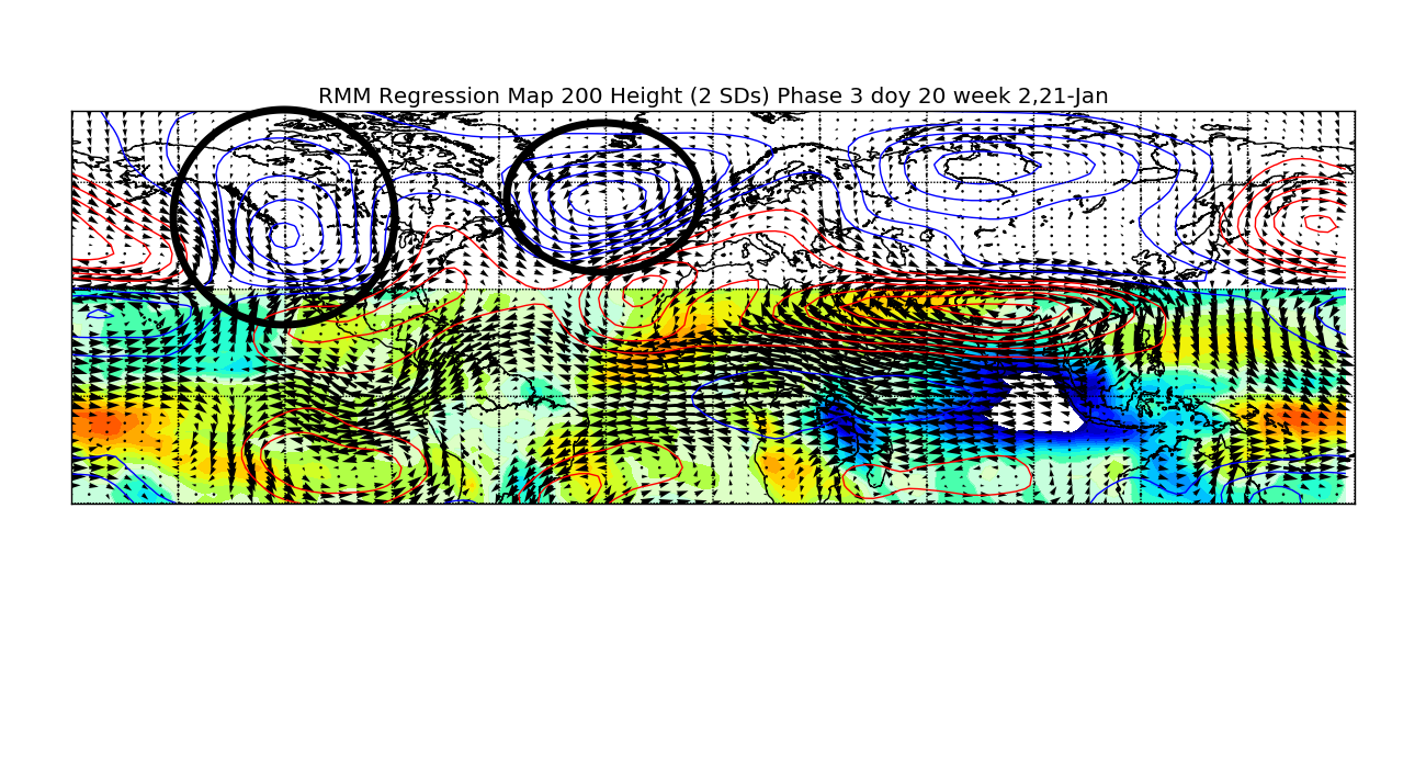
There is some uncertainty regarding how the MJO evolves beyond the next 10 days. Many ensemble members have the wave weakening and moving into the “circle” in the day 15-20 range (blue and green dots, valid the 2nd week of January). A number of members maintain amplitude into phase 3 and a growing number into phases 4 and 5. While that initially seemed unlikely (and the mean forecast does still move into the circle by mid January), an increasing number of members have the more amplified outcome across the Indian Ocean and towards the Maritimes. The ongoing stratospheric warming event may support a stronger and more amplified MJO moving across the Indian Ocean and into the western Pacific mid-late January…this is a trend worth monitoring. Even a phase 3 MJO in early January suggests a trend to a more -PNA/west coast trough:
To sum up where things are so far:
Tropical forcing, mountain torque/the Pacific jet and stratosphere support a pattern change over the next several days. This will increase polar influence into Canada and the U.S. and favor development of an eastern U.S. trough to start January. Mountain torque and tropical forcing suggest continued Pacific jet retraction in early to mid-January, which will support ridging retrograding from the west coast towards Alaska as troughing over the eastern CONUS also retrogrades/shifts west. This will support colder temperatures moving into southern Canada and the U.S. with some increase in snow potential. The sub-tropical jet will remain active with shortwaves moving through the Southwest and ejecting east into the southern Plains in early to mid January.

The pattern could favor a wintry threat from the Four Corners and southern Plains towards the interior Southeast/Mid Atlantic the first few days of January. It’s questionable if enough cold air can build by then for more than an elevation snow threat in the eastern U.S. with any sub-tropical waves moving through, and many ensemble members don’t have much of a system.

The next shortwave in the very active sub-tropical jet ejects into the Plains January 5-6. By this point, there will be much more polar and even arctic influence on the pattern with a lobe of the tropospheric polar vortex near Hudson Bay and some cross-polar flow into Canada. The sub-tropical jet shortwave may interact with a northern stream shortwave as it moves east. This interaction will prove key to any resultant low pressure development from the southern Plains or Mid South region towards the Ohio Valley or Mid Atlantic. If the polar jet is too fast or dominant, we may just get a clipper and a suppressed sub-tropical jet shortwave that don’t phase. If the features are able to phase and low pressure develops, snow would be likely north/northwest of it with some cold air damming east of the Appalachians thanks to upper-level confluence caused by modest downstream blocking over the North Atlantic. While this is still a long ways out there there’s a signal for a system potentially bringing a broad swath of snow across the central and eastern U.S. in the January 6-8 timeframe.

With such an active sub-tropical jet the shortwaves will eject out of the Southwest every 2-3 days, with the next strong signal for a shortwave to eject on the ensembles January 8-9. By this point the mean trough axis will be shifting farther west, making it more likely for any low pressure to track towards the Great Lakes with snow possible to its north and west. If we see a notable low pressure over the eastern half of the CONUS to start the second week of January it could re-enforce North Atlantic blocking and pull in colder air behind it, possibly delaying the development of an eastern U.S. ridge.

Looking further ahead, a solid majority of EPS members have a significant stratospheric warming event (SSW) between January ~4-12. If this occurred it would lead to greatly increased potential for sustained high-latitude blocking beginning during the second half of January and persisting well into (and perhaps through) February. It is very common for a warm-up to occur over the central and eastern U.S. as a stratospheric warming event is ongoing before any blocking it sets off can establish itself. This would line up with hints of a -PNA and perhaps +EPO towards the middle of January.

Looking at lower-frequency tropical forcing, it has been amplified over the central Pacific (near 180 longitude) and over the western Indian Ocean (near 25E), roughly outlined by the green boxes. Tropical forcing has generally been suppressed between these two areas. The tropical forcing has moved through the western hemisphere (phase 1 MJO and favorable for colder weather) every 3-4 weeks.
If this type of oscillation continued it would move back through the western hemisphere by the middle of January. However, it seems like the tropical forcing was largely driven by faster-moving Kelvin Waves until the two most-recent orbits, which featured stronger and slower-moving anomalies more typical of the MJO. This most recent pass remained strong through the low frequency eastern Indian Ocean subsidence and took closer to 4-5 weeks to return to the western hemisphere. If this more recent trend continues it will return to the western hemisphere in the ~3rd week of January, potentially supporting development a more favorable Pacific pattern (Aleutian low, west coast ridge) along with a -NAO. The stratospheric warming event that will be ongoing over the pole over the next two weeks will lead to a colder lower stratosphere over the tropics, which may amplify and slow down the progression of the MJO. I would say smart money is on tropical forcing becoming favorable for a western North America ridge to return during the last week of January. Potential exists for prolonged -NAO blocking by then if we do in fact see a major stratospheric warming event (which currently appears more likely than not during the first half of January).
To sum up, a cooldown is expected into the first week of January, leading to a favorable pattern for any amplified southern stream system to bring snow potential to the central and eastern CONUS. There will probably be enough polar and arctic influence for a modest clipper or two and some lake effect. A trend towards a trough with colder air over the western U.S. and ridging farther east is supported for the middle portion of January. By the end of January potential appears to be there for impacts from a stratospheric warming event and tropical forcing to support a western North American ridge, eastern trough, and high-latitude blocking with an active southern stream. This would lead to a few week period of more wintry weather, and while unlikely to completely make up seasonal snowfall deficits in large portions of the northern U.S. could salvage a semblance of a winter.
