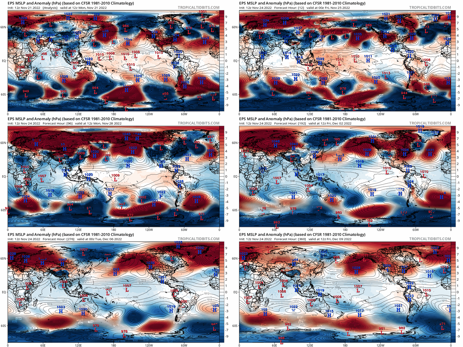
Just wanted to throw a few loops from the 12z European ensemble in here…the ensembles are increasingly keying on a pattern featuring a -EPO (Alaskan ridge) and -NAO (Greenland ridge) into the first half of December, though with an initially -PNA (western US trough). This would support colder air pressing back into the CONUS starting early next week out west after a relatively brief hiatus. With an initially -PNA the cold air will first focus out west with mild weather over the eastern U.S., though a persistent -EPO and eventual -NAO could change that. Ok, time for some loops:

So to start, the pattern early in the loop is a mild one across the CONUS. There’s troughing over Alaska (a positive East Pacific Oscillation/EPO) that’s flooding much of the CONUS with milder air after our impressive mid-November chill. With a -PNA (Aleutian ridge/west coast trough) any limited cooler air is going into the western U.S. right now.
But, focus on Scandinavia (northwestern Europe). A persistent Scandinavian block has been ongoing and is progged to amplify this week. First, it sends a blast of cold air into Siberia and the rest of eastern Asia, a key to changing the Pacific pattern. Then, the block is shown on the European ensemble mean to retrograde towards Greenland, causing a negative NAO to develop through early December.
This Scandinavian ridge/block has been persistently modeled for a couple of weeks, which is impressive…and it’s also a pretty important piece to the puzzle. The set-up, as everything is currently modeled, seems to support both a -EPO and -NAO developing through the first half of December.

The blast of cold air into eastern Asia sends strong high pressure down the eastern side of the Himalayas, in contrast to the current low pressure over eastern Asia. Low pressure lowers the resistance against the planet’s rotation east of these tall mountains, allowing the planet’s rotation to speed up ever so slightly. To conserve angular momentum, the Asian-Pacific jet slows down and retracts. This favors anomalous ridging over the northwestern Pacific and low pressure over western North America…not a cold pattern for the Lower 48.
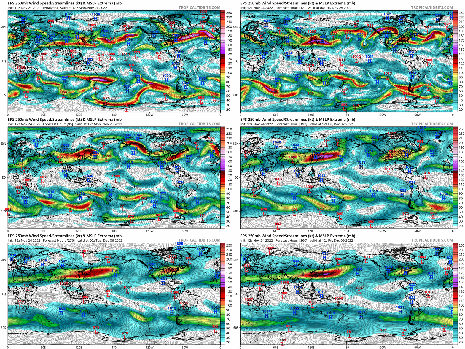
Fast forward to later this week and beyond, when high pressure drops in east of the Himalayas and does the opposite, speeding up and extending the Asian-Pacific jet. This favors lower pressure over the northwest Pacific in the exit region of the jet and pushes the ridge east, while the added momentum into the Pacific jet amplifies that Rossby wave train. Low pressure over western North America is replaced by high pressure descending out of the high latitudes. It’s a much colder pattern for most of the CONUS, though the East Coast will be the last place to consistently get the cold.
Also note how Rocky mountain torque is demonstrably important. Early in the loop, high pressure east of the Rockies is in place, which favors intensifying/extending the jet over eastern North America and into the northern Atlantic. This favors low pressure over the North Atlantic in the left exit region and a +NAO. However, a series of low pressure systems developing east of the Rockies in the middle portion of the loop does the opposite, retracting the jet and giving the Scandinavian block room to retrograde.
I think at this point we just need the damn 250mb wind loop:

Early in the loop, the jet streak is breaking near the coast of East Asia and the north Pacific ridge is well to the west. As the jet extends in response to the East Asian Mountain Torque, that ridge is pushed east, a pattern much more conducive for pressing cold air into Canada and towards the continental U.S…also check out the Atlantic. Initially, the jet is roaring off the East Coast, but as low pressures develop east of the Rocky mountains and cause a negative mountain torque, the jet pulls back and allows ridging to retrograde over the North Atlantic. This causes the NAO to trend negatively, and is more conducive to troughing over the eastern U.S.

Another way to visualize this chain reaction…cold dumps into eastern Asia. Alaska then goes from cold to mild. Cold air then begins pressing into the CONUS. As ridging retrogrades over the North Atlantic and cold continues to funnel into the west, increasing pressure is put on the Southeast ridge and the eastern U.S. gradually sees cooldowns. Probably a very up and down pattern in the east, and leaning much colder west. In general, as the highest latitudes warm, the mid latitudes cool.
The MJO is moving into Phase 7 at a high latitude for the second time this month, and it could end up squeaking into 8:

Convection has been favoring the eastern Indian Ocean/western Pacific all summer and fall, a classic more “eastern based” La Nina response:

In the late fall/early winter, a phase 7 MJO is typically followed by ridging near Alaska and Greenland, a -EPO and -NAO respectively, with cold first dropping into the west and then spilling east. We are approaching Lag=0 now and will be Lag=1 and 2 next week into the following week (each lag is 5 days):

Lots of stuff pointing to a -EPO and -NAO and resulting colder pattern over the CONUS and slightly thereafter Europe as well…though don’t overlook the initial -PNA and Southeast Ridge causing cold to go into the western U.S. first.
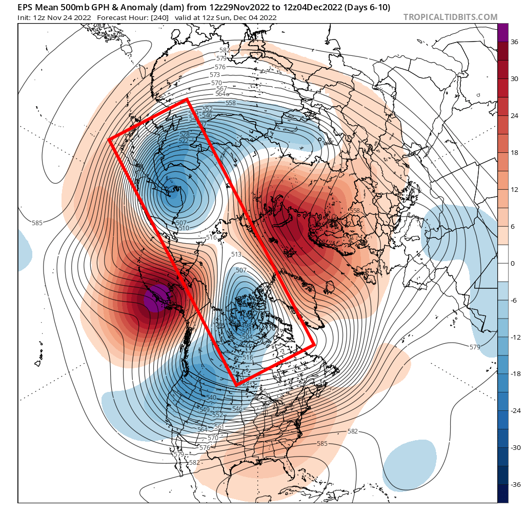
Can this return to cold through early December bust? As always with a longer range forecast, yes. My main concern is where the tropospheric polar vortex ends up, and if it splits as quickly as modeled over the next 7-10 days:

In particular, my concern is where the lobe over northeast Asia ends up. If it ends up dropping a bit farther east, it could mute any ridging into Alaska. I feel that’s on the less likely side, but it’s slightly precarious. If we see the tropospheric polar vortex split like the ensembles currently show, with one lobe into Siberia and another into northern Canada it bodes towards the colder outcome being favored over North America in December.
