
The Key Points Up Front:
1. Any views here are mine and are done for fun, and don’t represent anyone else’s
2. The pattern of “cold west, warm east” continues through most of this week. Cold and fairly active weather will continue across the western U.S.
3. Later this week into this weekend, cold spills into the central and eastern United States. The pattern then remains fairly chilly across the Lower 48 for a couple of weeks, with the coldest overall conditions across the northern Rockies and northern Plains
4. This colder pattern may be somewhat dry overall. With that said, some snow may occur from a lee cyclone late this week/early this weekend across the Upper Plains/Midwest…then, lake effect snow, a minor clipper or two, or perhaps a wave riding along the baroclinic zone (if there’s any sub-tropical jet activity) may bring some potential for snow farther south/east next weekend or beyond. Not a big winter storm pattern, but not hopeless for a bit of snow.
5. Several signs point towards the weather pattern in much of the continental United States trending mild yet again towards the end of November and early December
6. A few analogs and early signs in extended guidance suggest the potential for increased high-latitude blocking and colder weather may return into December. Given the ongoing La Nina and -PDO, confidence in this occurring isn’t high yet. However, the coldest December since at least 2016 is distinctly possible if things align properly.
The Details:
After a very chilly first half of October, which was enough to plunge most of the eastern U.S. to below normal values for the entirety of the month, mild weather has dominated the pattern over much of the central and eastern U.S…this pattern continues into this upcoming week, but the GFS and Euro ensembles both indicate below average temperatures over fairly decent stretch for almost the entire CONUS closer to mid-month:
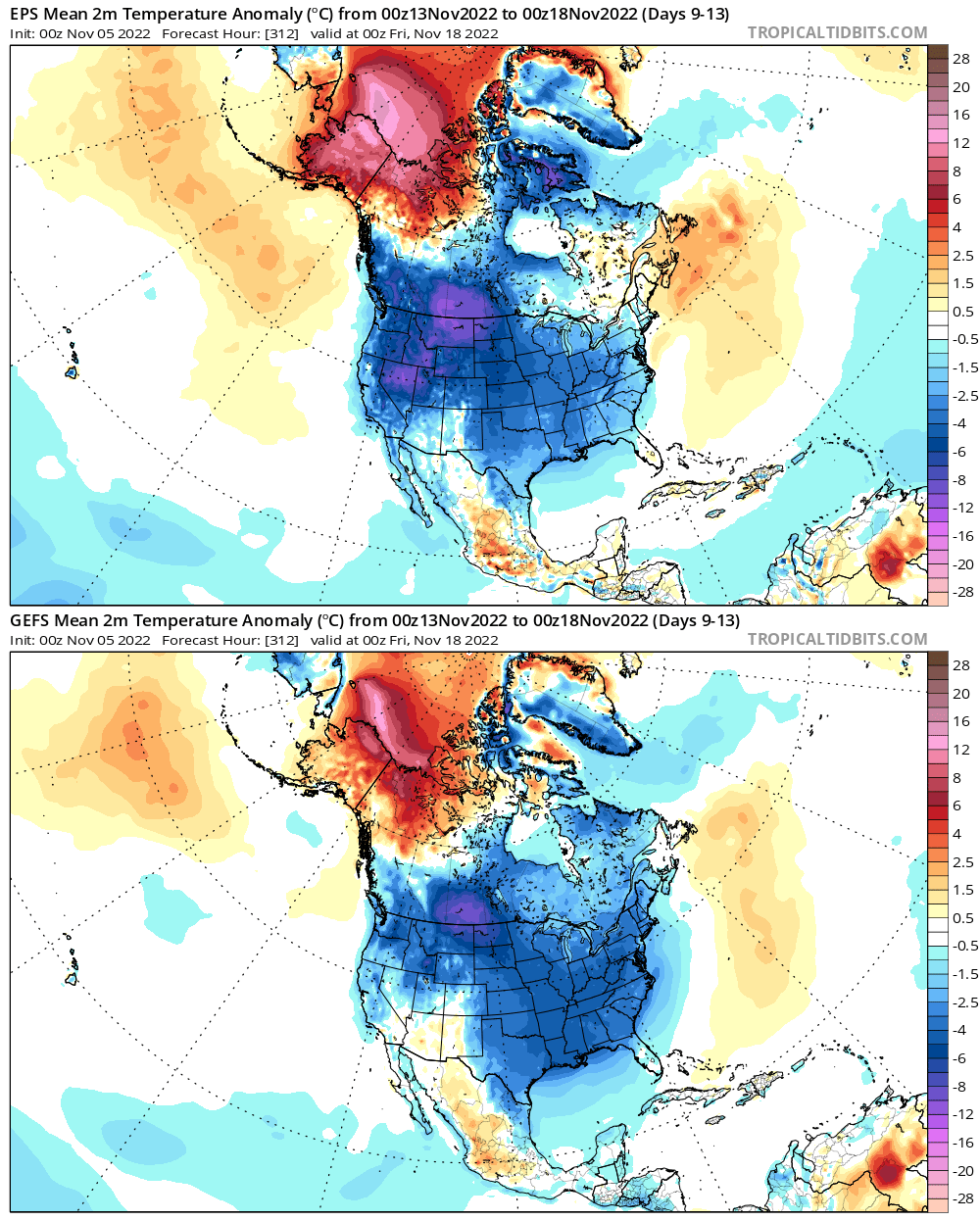
It’s getting to be the time of year where colder anomalies have some more bite and can start bringing snow to more of southern Canada and the Lower 48. This cooldown has trended more and impressive as it moves up in time on the models, evidence by this GFS ensemble trend loop for the same time period:

After such a prolonged mild spell, is this cooldown shown in the medium to long range feasible, and how long may it last?
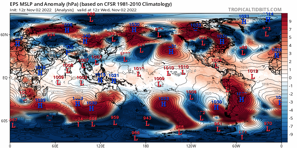
Looking at a few things, including the character of the Pacific jet stream and the MJO, suggests that the projected cooldown on the ensembles has legitimacy. Let’s start with the pattern over the last week leading up to Friday:
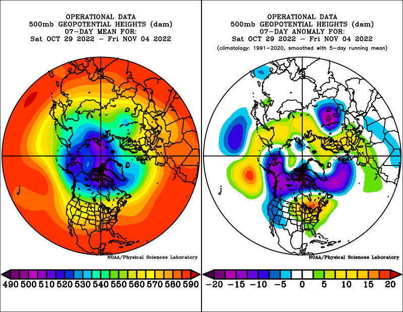
The pattern is undoubtedly a warm one for the central and eastern CONUS and into southeastern Canada, with a positive AO (PV generally tight and confined to the high latitudes), a very positive EPO (the trough over Alaska and western Canada), a negative PNA (Aleutian ridge and West Coast trough), and positive NAO (trough over the north Atlantic).
The above pattern correlates very nicely to the expected pattern when the Pacific jet is retracted, as it has been most of late October and very early November per the above chart:

The flat ridge south of the Aleutians, trough over Alaska and western Canada/the western US, and downstream ridge over the eastern US are quite characteristic. There are a couple of ways to analyze how the Pacific jet is progged to behave on current guidance over the next week or so…one is just to throw in a loop of ensemble mean forecast 250mb winds:

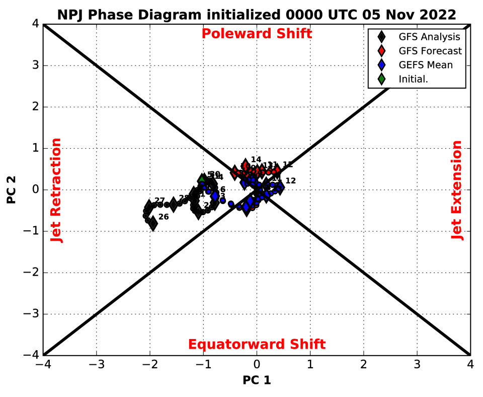
We start off in the middle of last week with a “jet retraction” look, with the jet barely extending off of Asia and a ridge over the Aleutians, directing the jet stream towards Alaska and the northwest coast of North America, helping facilitate the current very mild pattern across a good portion of the Lower 48. However, quite a bit of westerly momentum is getting added as I type this and into early this week. Initially, the ridge near the Aleutians just amplifies and disperses a lot of this added momentum around it, but eventually the jet extends and pushes the now-amplified ridge east, facilitating cross-polar flow into North America and really cutting off the Pacific influence by this upcoming weekend. Here is the GEFS forecast Pacific jet character:
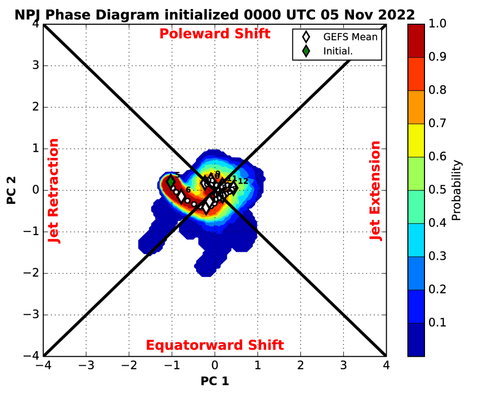
A similar trend, from a pronounced jet retraction in late October towards neutral, with perhaps some modest lean towards an equatorward shift or jet extension over the next week or so. Here are what a Pacific jet extension or equatorward shift tend to look like:


Note the trend towards much higher heights into the northern Pacific and Alaska, with resultant troughing and colder weather over a good portion of North America…in particular, over western and central Canada into the northern Rockies and Plains with an equatorward shift, but bleeding towards the East Coast. The equatorward shift looks more like a -EPO but still somewhat negative PNA, while the jet extension looks more like a classic +PNA with a somewhat negative EPO. This generally matches the ensemble’s forecast pattern over the next week or so:


The impetus for this change seems to be a combination of increased east Asian mountain torque and tropical forcing working out of the eastern hemisphere and into the western hemisphere early this month. Initially, the pattern this weekend into the first half of the week simply looks like a significant amplification to the going pattern:

At first, we just see the ridge south of the Aleutians amplify, which amplifies the downstream pattern over North America (western trough and eastern U.S. ridge). However, this very mild look over the eastern U.S. doesn’t last too much longer as the ridge amplifies into Alaska, forcing cold south towards the CONUS, and then east as an Aleutian low develops. An Aleutian low is a trend towards a more positive PNA.
Note positive MSLP anomalies (high pressure) dropping into eastern Asia right around now, signifying a significant increase in east Asian mountain torque, which results in added westerly momentum to the east Asian-Pacific jet. There may be another push later this upcoming week, before a fairly well agreed upon trend towards a much more negative east Asian mountain torque into mid-November:
Positive East Asian mountain torque tends to result in an extension of the Pacific jet and subsequent rise in the PNA, as the extended jet and associated left-exit region towards the north-central Pacific tends to favor low pressure over the northwest Pacific or Aleutians and subsequent height rises to the east closer to the West Coast of North America.

At the same time, the MJO has come out of the Maritimes and into the western Pacific at a fairly high amplitude, and is now quickly working into the western hemisphere. The satellite/VP anomaly loops over the last two weeks show a similar trend as the above RMM plot, with strong uplift over the western Pacific until the end of October quickly shifting east. Note how areas that had the strongest upward motion (~120E) at the beginning of the loop have strong sinking motion now, and vice versa over portions of the central and eastern Pacific. Clearly, the tropical forcing is changing from the forcing that led into our current very mild pattern.

After a decent Phase 7 passage, an increase in blocking near Alaska in October-December is quite common:

We are not going to get the NAO help in the short term, but blocking located near Alaska/a -EPO is often common during and following a phase 7 MJO this time of year as seen above. The MJO is about to briefly get into Phase 8, which also often leads to a colder outcome into the southern and eastern U.S. than a Phase 6-7 in the fall:

And for what it’s worth, the same October-December lagged composites from the CPC for a phase 8 MJO, which is briefly occurring right now:

The issue with these is that the pattern right now into this week, which would be a “Lag=0” for the current phase 8 RMM indication, is that the NAO is quite positive with a deep trough out west. That said, a phase 8 MJO this time of year often corresponds to immediate and short term blocking, with an Aleutian low/+PNA and colder trend over most of North America. This is then followed by the PNA trending more negative and blocking generally breaking down within a few weeks of the phase 8 MJO occurring.
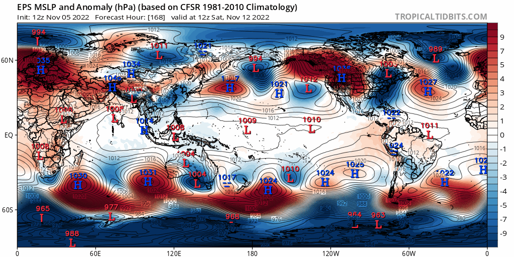
Despite the phase 8 MJO pointing to a -NAO, I am fairly confident it will remain positive for the next 10-15 days. This is because the stratospheric PV, while getting stretched a bit at times, is going to remain on the stronger side of normal, which argues towards a +NAO for now. In addition, recall back to this EPS mean sea level pressure/anomaly loop:
Note multiple high pressure systems dropping in just east of the Rockies over the next 10 days. The Rockies are not quite as tall as the Himalayas, but they’re still plenty tall enough to produce a mountain torque that requires increased momentum in the jet stream to conserve angular momentum in this equation (the positive mountain torque removes momentum by slowing Earth’s rotation slightly). This speeds up the jet over the eastern U.S. into the North Atlantic, encouraging positive NAO trends. Given that the NAO has been positive since late October, I don’t see it flipping negative in the face of this through at least the middle of November.
Looking Beyond Mid-November:
A dramatic shift to a colder pattern in the CONUS, first into the Pacific Northwest over the next few days and then expanding into the rest of the CONUS through next weekend and through mid-November is agreed upon by the major ensembles and seems very well-supported by various forcing mechanisms…driven by a plunging EPO and rising PNA. But how long will it last, and does it mean shit for the approaching winter season as a whole?
To answer the first part of this question, we will examine things such as mountain torque and tropical forcing yet again. Starting with mountain torque, and picking up closer to mid-November, after our upcoming increase in mountain torque and injection of westerly momentum into the Pacific jet:
Positive east Asian mountain torque is ongoing at the start of the loop, but as low pressure develops over much of southeast Asia, this becomes negative, reducing westerly momentum into the Asian-Pacific jet around mid-November. This suggests the jet will have a tendency to retract again, which would render the upcoming PNA spike brief and could eventually cause the EPO to start trending more positive again.
Remember, we are in a La Nina with a solid -PDO, evidenced by the cool tongue across the equatorial Pacific, the warm waters over the northwest Pacific, and the cool waters south of Alaska:

These both favor a -PNA and often favor a predominantly +EPO as well. We look to buck that over the next week due to tropical forcing progressing through the Pacific and Western Hemisphere and due to a positive east Asian mountain torque, but when those shorter term pattern drivers subside, the lower frequency forcing can often dominate yet again. So, the expected negative east Asian mountain torque towards mid-November is a signal that a more -PNA and more neutral EPO is a distinct risk into the latter portions of November given the background forcing.
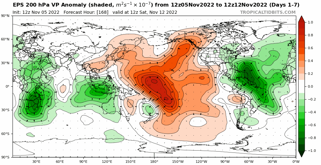
Most guidance (the European ensemble shown above) suggests tropical forcing quickly progressing through the western hemisphere over the next week or so, with eastern hemispheric forcing (in particular, over the eastern Indian/western Pacific oceans) becoming dominant once again towards the second half of November. Given the background state, this seems very plausible after the current higher frequency forcing moves through the western hemisphere in the shorter term. RMM forecast plots also indicate similar, with the ongoing Phase 8 MJO not lasting long and then becoming “indeterminant” (which usually means lower frequency forcing can exert more influence again). Thereafter, the MJO may move into phases 5 or 6 after the 15th. Here is the European ensemble forecast MJO progression through November 19th:

Recalling back to the above October-December MJO phase temperature correlation plot above, phase 6 is quite mild in the CONUS. This general evolution (eastern Indian/western Pacific Ocean tropical forcing becoming dominant again into mid-November) is well agreed upon by various medium to long range forecast models/ensembles. In addition, the water temperatures support convection and tropical forcing wanting to favor this general region again, as does where enhanced convection/upward motion has been most persistent in recent months near the equator:

So, the background pattern suggests a risk for a retracted Pacific jet and -PNA/+EPO to return when other shorter-duration forcing weakens. In addition, there’s fairly consistent indication that the shorter-duration forcing (mountain torque, MJO) will weaken and may in fact positively feedback with the “background” La Nina pattern into late November.
There’s enough support for a significant cooldown that it will take some time for milder weather to return, we’ll probably have a full 1-2 weeks of generally cold conditions (for this early) across the CONUS. However, many indications are that milder weather gradually returns from west/southwest to northeast in the second half of November.
In terms of snow potential over the next few weeks, the higher elevations over much of the western U.S. will remain cold and active through this week with a -PNA and dropping EPO. As the cold ejects east late this week, a lee cyclone may bring snow potential to the northern Plains and Upper Midwest. Thereafter, it looks like a fairly dry EPO-induced cool/cold shot into the central and eastern CONUS. Not all hope is lost, as some snow may occur via lake effect, weak clippers, or perhaps any waves riding along the baroclinic zone if the sub-tropical jet isn’t totally quiet. Likely not a pattern that supports a widespread, major winter weather event (especially in November), but it’s possible some minor or localized snow events occur outside of the mountains starting this upcoming weekend and through roughly Thanksgiving.
Some Fun With ENSO/MJO Analogs:
The rest of the winter is not yet lost though. In fact, the findings discussed below are what prompted me to make this whole thing a blog post instead of a Tweet thread. I just thought “there’s a lot here, let’s try to tie it together better than intentionally cryptic Tweets would”.
This much MJO activity in the fall leading into a La Nina isn’t too common. Since 1975, only 4 La Nina Novembers saw the MJO move into both phases 7 & 8 at an amplitude of greater than 1. Those are 1996, 2000, 2010 and 2016. Oh, there’s that fabled 2010-11 analog. We also have a very negative IOD and solidly westerly QBO. Let’s see if we can leverage those high-confidence, long-duration pattern drivers. We have a negative IOD this fall and will have a westerly/positive QBO through this winter, full stop.
2010 and 2016 had a westerly QBO
1996, 2010 and 2016 had a negative IOD
How did those 4 years play out during December?
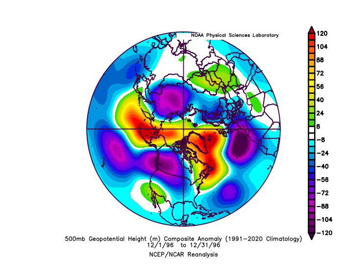
All but 2010 had a solid -EPO, and 2010 still had very pronounced north Pacific ridging along with a a huge -NAO. All but 2016 had a -NAO. All but 2000 had a -PNA. All but 2016 had a -AO. Here is a look at the October-January monthly temperature and precipitation anomalies for these years (weighted slightly based on QBO/IOD matches):

For reference, here are October’s temp/precip anomalies:

Overall, the October pattern this year actually resembles those analogs, though with the pattern seemingly shifted west slightly. The very warm start to November likely dooms the eastern U.S. to finish with a somewhat mild overall month, but the pattern after this week may resemble these years in November fairly well. It’s at least in the ballpark enough that these analogs aren’t immediately invalid.
I believe how the MJO and mountain torque play out during late November and into December will heavily influence if the potential for a very blocky, cold, active December comes to fruition given the risks for a milder pattern (at least temporarily) returning by the end of November. Just looking at some various products, the EPS (already shown), GEFS, and Australian BOM MJO forecasts:

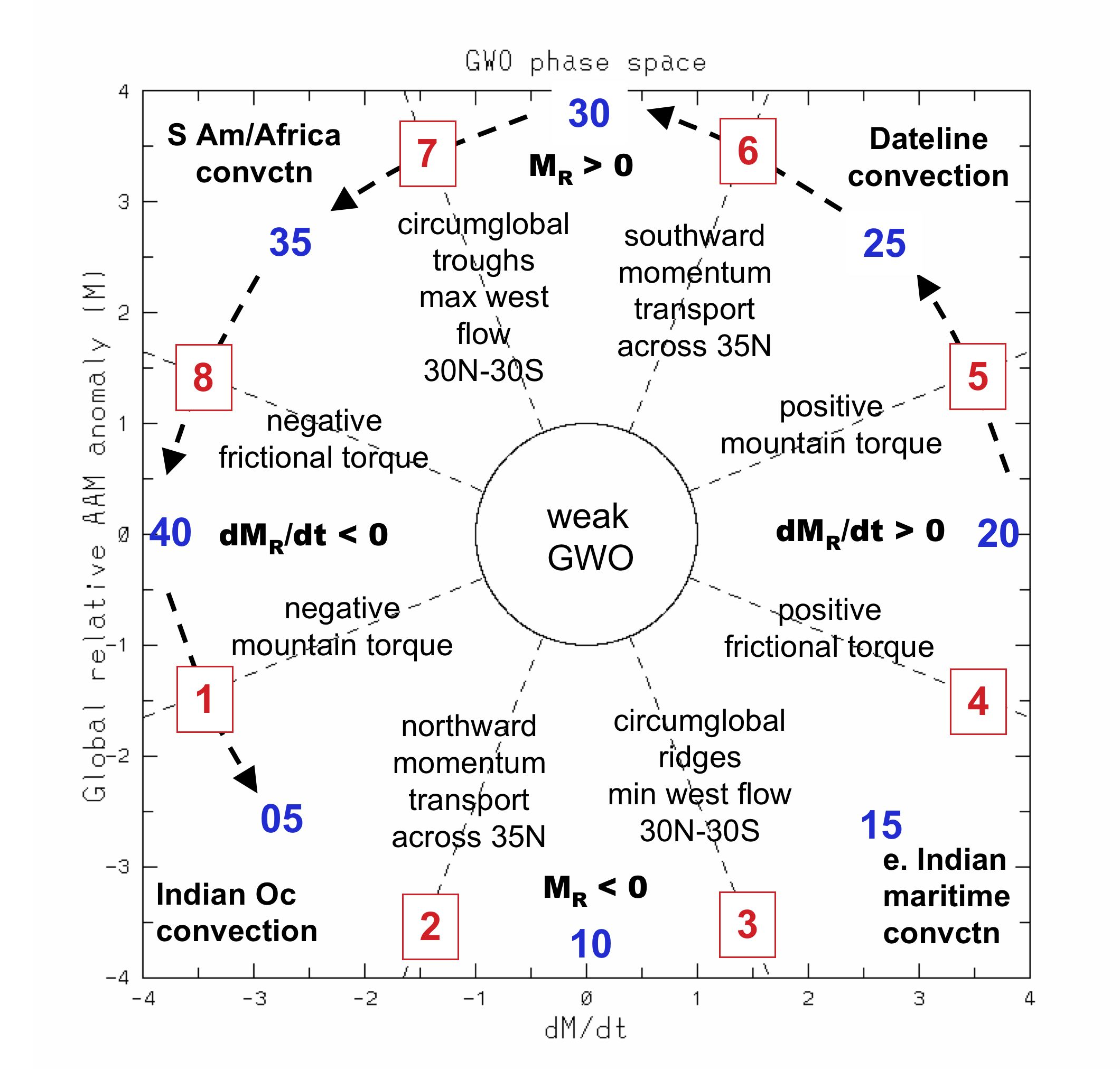
The GFS/Euro both have the MJO strongly and definitively progressing through phase 6 and towards phase 7 into late November. This could be indicative of a similar angular momentum/global wind oscillation orbit to what we are currently seeing, as per this CFS forecast:

An orbit through phases 5-7 (as has recently occurred) supports convection moving east towards the Dateline and eventually the western hemisphere, along with positive mountain torque and troughiness into the mid-latitudes:
With that said, we are fighting the background state and there is some uncertainty to how all of this progresses 10-20+ days out. Getting the tropical forcing to propagate east again (as the GFS/Euro ensembles are suggesting towards late November) and getting another push of increased east Asian mountain torque is likely critical towards the door being open for a very block and cold December with elevated snow potential across a good portion of the CONUS. If not, the chances for a mild start to the winter quickly increase.
