
A regional severe weather event/potentially outbreak is likely on Monday across parts of the Upper Mississippi Valley east into the Great Lakes. All modes of severe weather will be possible, however, uncertainty mainly regarding ongoing convection remains in this forecast.

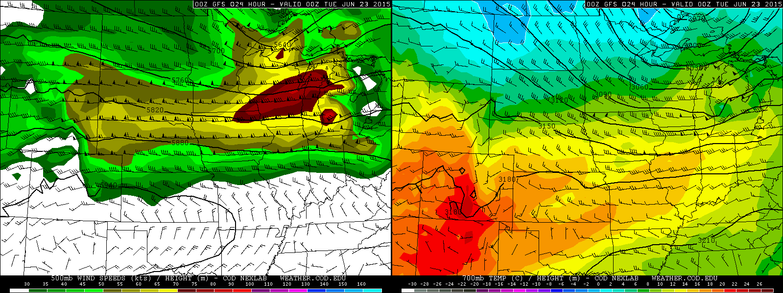
Current water vapor imagery shows two pertinent mid to upper-level speed maxes in the flow…one over the northern Rockies ejecting into the northern Plains, and another over southern Alberta/Manitoba moving southeast towards the northern Plains. These two speed maxes will partially phase and result in an impressively strong (by late June standards) speed max over the upper Midwest on Monday that will move east into the upper Great Lakes Monday night.
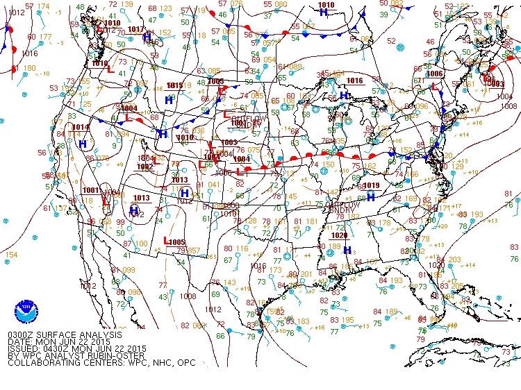
Recent surface analysis depicts a seasonably strong lee cyclone across the central Plains, with a warm front extending east across the upper Mississippi Valley into the northern Ohio Valley. South of this warm front, rich low level moisture characterized by low to mid 70’s dew points exists.

In addition, strong mid-level lapse rates due to a stout Plains elevated mixed layer (EML) are present across the central Plains and they are advecting east due to strong W-SW mid-level winds. These lapse rates are evident on several 0z 6/22 observed soundings across the Plains including SGF, TOP and OAX.
The combination of steep mid-level lapse rates and rich low-level moisture would result in strong to extreme instability where convection isn’t ongoing in the morning to try to overturn this environment.
In addition, the strong mid to upper-level wind fields will cause the surface low over the Plains to strengthen to seasonably strong levels over the northern Great Lakes by Monday evening, resulting in strong speed shear and reasonable directional shear in the warm sector.
From a synoptic/ingredients point of view, the potential for a significant severe weather episode appears to be on the table from the upper Mississippi Valley east through a good portion of the western and central Great Lakes…however, an ongoing MCS will potentially throw at least some sort of a wrench into the overall threat.
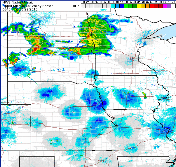
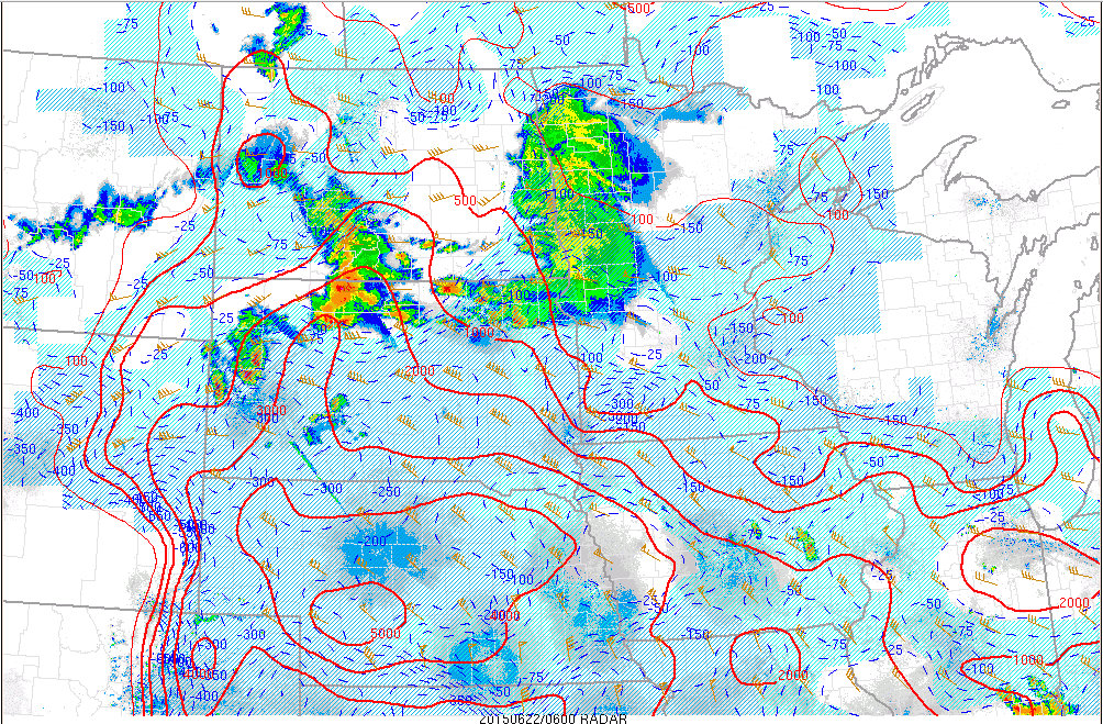
Convection is gradually growing upscale across the High Plains as of 6z…with the line from north-central SD into south-central ND making the strongest strides. With already strong instability and shear in place across the region per 0z observed soundings and recent mesoanalysis, I’d have to think that this activity will continue through the night.
Although the nose of the low-level jet and mean winds suggest a more easterly motion to this MCS, the instability gradient and shear vectors strongly suggest a decent southerly component of motion with the ongoing MCS. This would likely take it into parts of southern WI/northern IL…IE the potential greatest risk area later in the day…by mid to late morning on Monday.
The convection allowing models have some differing ideas on how the MCS evolves…recent HRRR runs agree with the above assessment, and the 0z SPC and NSSL WRF models are generally close to this or perhaps a bit slower. The 0z NAM, HRW and NMM all have the MCS, but track it into MN by 12z and quickly weaken it thereafter as it moves generally easterly Monday morning.
Given the current propagation of the storms (a fair southward component of motion) but strong agreement on the MCS remaining strong through the night, I’d have to lean towards the southern/somewhat faster camp for the MCS track into Monday morning (which isn’t exactly uncommon), which takes the MCS into southern WI/northern IL before 18z. This has implications on the threat zone, as the MCS will overturn the atmosphere where it passes and also potentially limit moisture/instability advection north of where it tracks.

Assuming the MCS gets east of IL/WI by 18z, the strong low to mid-level wind fields combined with the rich low-level moisture and steep mid-level lapse rates in place will likely allow for fairly rapid recovery. However, if the MCS is slower moving or back builds, then recovery farther north ahead of the cold front into areas like WI and MI may be more questionable.
The NAM and HRRR have somewhat different MCS evolutions…the 12km NAM is a hair slower and farther north with the MCS, while the HRRR is a little faster and farther south. Compare the simulated radar products valid at 18z:
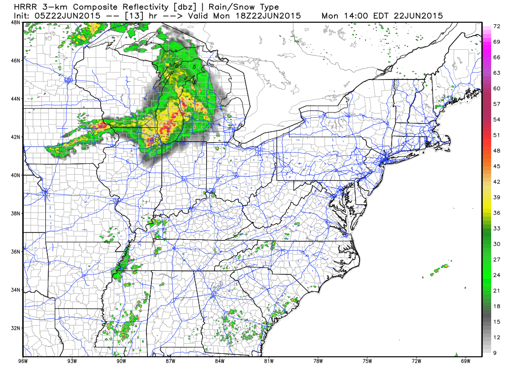
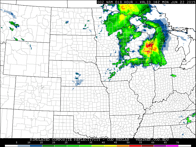
Both models show an attempt at some back building convection across NE IA and N IL behind the main MCS, however, they show dramatically different instability outputs behind the MCS:


Both models agree on extreme amounts of CAPE in the clean warm sector…however, the NAM is much more optimistic about recovery behind the passage of the MCS across portion of MN/WI/N. IL. When parsing through other guidance, the 0z GFS isn’t as aggressive in recovering behind the MCS as the 0z NAM, but is more aggressive than the HRRR. The 0z SPC WRF is very bearish in post-MCS recovery. The 21z SREF is interesting…the mean appears to be close to the 0z NAM, however, there are at least a few members that don’t recover the airmass as aggressively across parts of northern IL/WI:

Considering that most of the SREF members appear to be farther north with the MCS than I expect (per 3-hourly precip fields), the fact that a few don’t recover the airmass as aggressively on the northern end of things suggests that the few that may have a realistic MCS depiction are also having trouble recovering the airmass behind it.
So, what we have at this point is a very complicated forecast…we have plenty of shear and instability in place for a high-end event, however a likely MCS may very well hinder the northern extent of that instability.
The reason the northern extent of the instability is of such concern is because the better upper level dynamics and shear will be located farther north…with warm mid-level temperatures and a stronger cap farther south.
Although the MCS may (in my opinion, probably will to an extent) limit the northward extent of extreme instability, it may leave outflow boundaries across parts of IA/northern IL that locally enhance wind shear later in the evening and also perhaps help serve as a focus for new convection by late afternoon/early evening. The MCS may still remain severe farther east across portions of southern lower MI, northern IN and northern OH.

The MCS threat across parts of the southern Great Lakes Monday afternoon/early evening is conditional on the overnight/early morning Plains/upper Midwest MCS developing a cold pool and/or MCV, which would allow it to sustain itself in a respectable form through the morning and into the afternoon. Based on cells continue to grow in spatial coverage and intensity as of this writing with the MCS, I’m leaning towards that happening, but it’s not quite a slam dunk. Regardless, the instability gradient and shear vectors continue to point to an E or ESE propagation of an MCS if it maintains itself across southern lower MI and northern IN/OH Monday afternoon and early evening. In addition, the instability ahead of the MCS is expected to become moderate by late afternoon as the Plains EML plume begins advecting over rich low level moisture across the upper Ohio Valley, with increasing bulk shear and helicity values as well. This points the MCS, if it can in fact become robust enough by morning, maintaining itself with a damaging wind threat through the afternoon across the southern Great Lakes. The MCS would likely eventually outrun the better instability and shear to the point where it would weaken by the time it hit eastern OH or western PA if this scenario played out.
As for the threat farther back west with the cold front itself and new convection firing, I see a few possible scenarios:
1) The MCS clears early enough to allow strong recovery into northern IL and southern WI, but recovery is less aggressive farther northern into eastern MN, northern WI and MI. Storms re-develop by mid to late afternoon as the speed max moves across the upper Midwest and western Great Lakes along the cold front and along any outflow boundary left behind by the MCS. In this scenario, severe weather would probably be most likely across eastern IA, northern IL and southern WI. All modes of severe weather would be possible with a few strong tornadoes possible within the first few hours of initiation. Given strong instability, shear and large scale ascent upscale growth into another ESE-ward propagating MCS would be possible by mid to late evening with a potentially high-end wind damage risk. Farther north in this scenario, isolated to widely scattered convection would likely initiate along the cold front across eastern MN/northern WI/western upper MI, however, with more limited instability and questionable coverage the severe threat would be somewhat lower. Due to the strong shear, all modes of severe would still be possible, but the higher tornado threat would be mitigated farther north. The storms would likely move east into the rest of upper MI and also northern lower MI by mid to late evening and then gradually dissipate overnight without growing upscale.
2) The MCS tracks farther north, allowing greater instability to occur farther north. The threat area would likely expand some into much of WI and SE MN, with potential upscale growth farther north. This scenario would potentially put more of lower MI in line for a second round of storms, especially farther south in the state…however, the storms would probably be linear or quasi-linear by the time they reached lower MI, which would temper the tornado threat there at least some.
3) The MCS breaks up by afternoon, allowing for strong instability to build into much of WI and lower MI. This would potentially be the worst case scenario as coverage of impressive parameter space would be greater. This scenario would also possibly open the door for a large scale threat into lower MI…the main risk would still be damaging winds, however more robust rotating updrafts within a QLCS with a somewhat better tornado potential would be possible. In this scenario, warm frontal storm development would be possible mid to late afternoon across much of lower MI in a moderate CAPE high shear environment, with some tornadoes being possible here as well.
In general, I think possibility 1) is most likely for reasons discussed above.
Overall, I am thinking that an MCS with perhaps a marginal severe threat tracks into parts of WI/northern IL by late morning or early afternoon and moves east into lower MI/N IN/N OH by mid to late afternoon with perhaps an increase in damaging wind risk as instability and shear begin to improve ahead of it. Behind the MCS, recovery occurs into all of eastern IA/northern IL and southern WI, with this area being in the sweet spot of strong-extreme instability, strong shear and weaker capping for re-development along the cold front and remnant outflow boundaries mid to late afternoon. This is where the best severe threat would be and where a few strong tornadoes are most likely. A few severe storms occur farther north in WI and upper MI, however lesser instability limits the coverage and intensity of storms some. I’m leaning towards this activity eventually growing upscale into an MCS by mid to late evening across northern IL/SW MI/NW IN. With strong shear overnight and moderate to strong instability remaining across the lower Great Lakes and northern Ohio Valley, a decent overnight MCS across parts of northern IN, northern OH and southern lower MI could be possible. In northern lower MI and the eastern UP, lesser instability may cause the storms to weaken some before getting there, keeping the threat non-zero but not extreme.
