Disclaimer: The thoughts expressed in this post are mine alone, and in making any life or death decisions be sure to consult the National Hurricane Center, your local National Weather Service, and heed advice from your local authorities and emergency managers.
National Hurricane Center: www.nhc.noaa.gov
National Weather Service: www.weather.gov
General Discussion:
Hurricane Joaquin has rapidly intensified into a major hurricane over the last 24 hours. As of 11:00PM Wednesday, Joaquin was located just northeast of the central Bahamas and moving southwest at about 7MPH. Joaquin was packing sustained winds of 115MPH and a central pressure of 951mb, making it a category 3 hurricane. The pressure with Joaquin dropped 20mb in 12 hours between 11:00AM and 11:00PM Wednesday and 37mb in 24 hours between 11:00PM Tuesday and 11:00PM Wednesday.
Joaquin has tracked farther south than forecast over the last 24 hours, which has immediate implications for the Bahamas. The vast majority of the island chain is under a hurricane warning, with tropical storm warnings for the westernmost and southernmost islands. Joaquin is still intensifying and has a good chance of becoming a category 4 hurricane Thursday into Friday as it moves very close to or over the central and northeastern Bahamas. Joaquin is expected to continue moving southwest through Thursday before slowly turning north by Friday, clearing the island chain completely by Saturday. Damaging winds, storm surge and flooding rainfall will occur in parts of the Bahamas.
After the Bahamas, Joaquin is still expected to move north on Saturday. Yesterday it was discussed that a bend back northwest in the track towards the Mid-Atlantic or Southeast coast was possible but NOT guaranteed. Due to Joaquin tracking farther south than forecast over the last 24 hours, the probability of a direct East Coast landfall has diminished considerably; a track out to sea now appears to be at least as likely as or somewhat more likely than an East Coast landfall. This is still far from a guarantee, so interests from Georgia to New England should still keep tabs on Joaquin.
Regardless of whether or not Joaquin makes landfall, tropical moisture interacting with a frontal boundary is still expected to produce heavy and locally flooding rain across parts of the Southeast US, Mid Atlantic and possibly southern New England Friday through Sunday, with strong onshore winds across the Mid-Atlantic causing at least minor to moderate coastal flooding and significant beach erosion.
Scientific Discussion:

As expected, Hurricane Joaquin looks much better organized than it did Tuesday night, with a symmetric CDO featured by consistent, extremely intense convection along with occasional hints of an eye today. The eyewall convection has at times exhibited a bit of a bursting pattern, some evidence that modest northerly shear and dry air may still be affecting the hurricane, however on the balance Joaquin’s inner core has gradually organized over the last day with rapid intensification occurring as a result.
Current satellite derived upper level winds continue to reveal an excellent equatorward outflow channel south of the hurricane, which along with warm waters and an unstable environment is allowing for very robust convection to occur consistently with the storm. There are still some hints at northeasterly shear in the upper level winds due to an upper level anti-cyclone to the west of Joaquin, with some dry air to the north and northeast of the storm, which may explain why the eyewall convection has bursted at times over the last 24 hours and prevented an eye to persistently maintain itself.
By Thursday afternoon and evening, the 0z Thursday GFS shows the northeasterly shear relaxing as Joaquin becomes more co-located with the upper level anti-cyclone that is currently shearing it. Given very warm SSTs across the Bahamas, with warmth extending down to a significant depth which will mitigate upwelling of cooler waters to an extent, and the very vigerous convection that has been consistently noted with the eyewall convection since Tuesday night, this relaxation of shear would likely allow the eyewall to become more symmetric and completely closed off, allowing an eye to form for good at some point on Thursday. Once an eye forms and clears, consistent eyewall convection to -80C or colder suggests that Joaquin should strength quickly to a category 4 hurricane and perhaps get close to category 5 status by Friday.
By Friday, outflow will be exceptional from Joaquin, with an upper low to the east and a trough digging over the SE US providing for strong dual outflow channels. Given continued warm water that Joaquin is still expected to be located over at this time, and the likelihood that a major hurricane will have a positive interaction with divergent and increasing upper level winds near the right-entrance quadrant of the jet streak east of the SE US trough, the potential does appear to be there for Joaquin to become a category 5 hurricane before the end of the work-week over or extremely close to parts of the Bahamas. There are two potential mitigating factors for this extreme intensification:
- Eyewall replacement cycles will likely start occurring at some point, resulting in fluctuations in intensity. Often times, eyewall replacement cycles that occur in storms outside of the deep tropics fail to successfully complete, leaving a weakened storm afterwards. Eyewall replacement cycles are difficult to predict more than 12 hours ahead of time.
- Upwelling of cooler waters. Although the Bahamian waters are very warm to a deep depth, a very slow moving major hurricane could eventually upwell enough cooler water to disrupt the inner core convection of Joaquin and cause some weakening. This is most likely to occur if a completely stall occurs.
Regardless, a major category 3 and most likely 4 hurricane is the expected intensity through Friday, with some potential for a category 5. This will occur very close to or over portion of the Bahamas, making this a very high impact event for the island chain.
After Friday, the intensity would likely slowly decrease as Joaquin either moves NNW towards the US Coast or more NNE out to sea as Joaquin begins encountering slowly cooler waters, some dry air and gradually stronger shear no matter which way the hurricane tracks. Different dynamics would be in play with both tracks would could result in slower rates of weakening, but overall a gradual weakening trend should commence by Saturday.
Yesterday I said there were 3 main track outcomes with Joaquin in the medium range of the forecast:
- “The trough digs enough and/or Joaquin is far enough north that the flow around the SE US trough pulls the system north or northwest. The trough and Joaquin phase and the trough becomes strongly negatively tilted and cut off, allowing Joaquin to likely move into the Mid Atlantic coast.
- The trough doesn’t dig enough, or Joaquin is too far south, and the trough kicks Joaquin to the northeast. The NW Atlantic ridge is too weak and the low south of the ridge too strong to push Joaquin back towards the US Coast, the storm goes out to sea.
- The trough starts kicking Joaquin to the northeast, but the NW Atlantic ridge is strong enough to keep Joaquin in the fray, and the system eventually starts bending back to the north-northwest, potentially towards the northern Mid Atlantic or New England.”
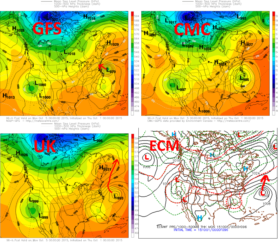
Yesterday, the trend among the models was for a stronger Northwest Atlantic ridge, a more aggressive digging with the SE US trough, and a track into the US East Coast on MOST models. The only model that never trended towards a landfall way over the last two days was the ECM/European model. As can be seen above, the 0z Euro and UKMET models now show a whiff well out to sea and a close buzz but miss respectively, while the GFS shows a storm trekking towards NYC and the Canadian shows a North Carolina landfall. The 0z GFS, while still showing an entertaining solution, trending significantly farther “right” (east/north) with its track of Joaquin in the medium term portion of the forecast, while the UKMET trended way right and missed the coast.
In general, the trends in the “big players” noted in my previous post have held true in newer modeling; the upper low gets all the way to central Alabama, with ridging over the NW Atlantic extending all the way into the Mid-Atlantic coast, allowing the steering flow off of the SE US coast to turn southeasterly by the weekend. However, there is one big change: THE LOCATION OF JOAQUIN! Joaquin has tracked much farther southwest over the last day towards the Bahamas, due to its stronger intensity allowing an upper level ridge currently west of the hurricane to have a stronger influence on the hurricane’s motion. I mentioned this in my post yesterday, but seemed to downplay its significance some:
“In the near term, as Joaquin continues to intensify, it appears that the ridge to its west may have increasing influence, as it appears to be stronger in the upper levels, per the layer of deeper steering currents shown in the above image. This could cause a west-southwest, but slow, motion to continue through the near term. However it’s important to note that if Joaquin does move farther north that it would feel increasing influence from the eastern US trough and ridge over the NW Atlantic. It’s also important to note that a stronger Joaquin would likely help pump up heights in the ridging over the NW Atlantic, which could ultimately try to push the storm farther west while also helping the trough over the eastern US amplify further.”
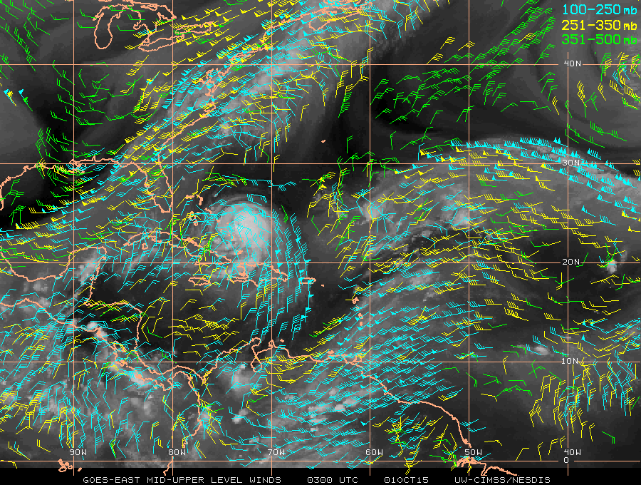
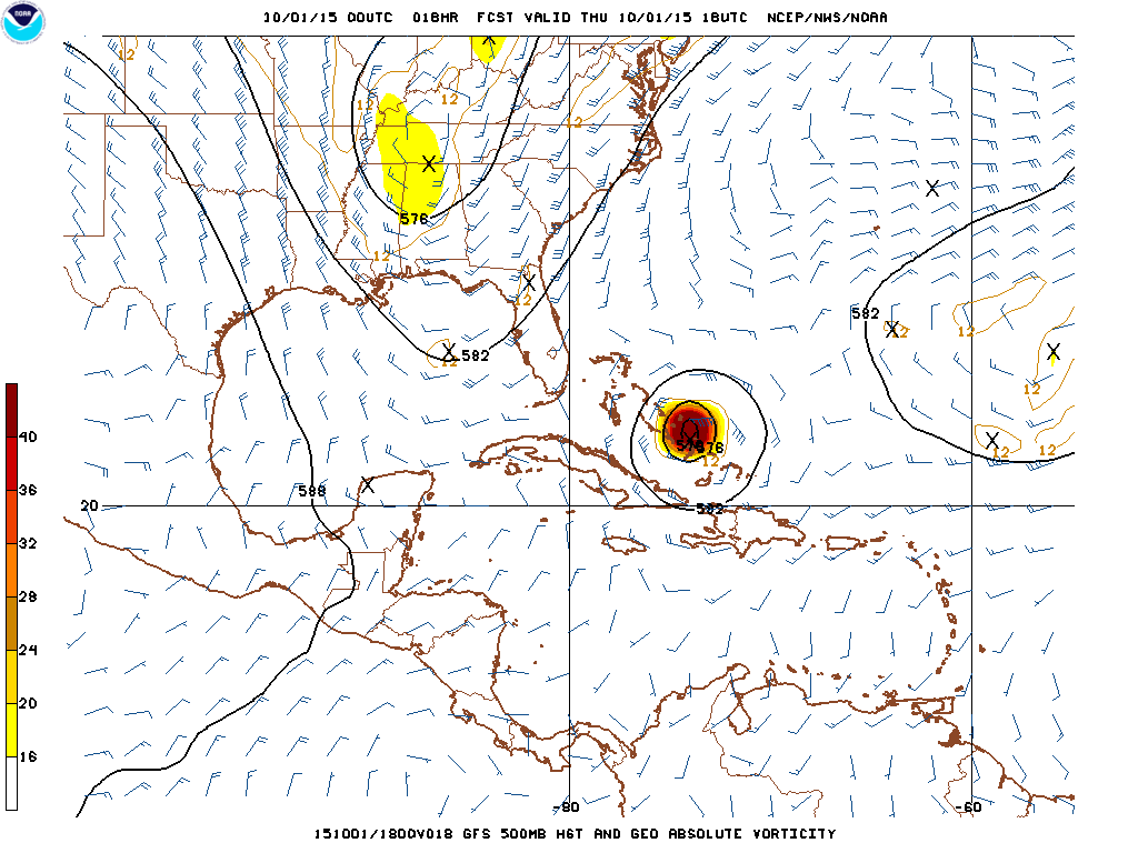
Although the latter portion of that paragraph is true, the NW Atlantic ridging and SE US trough will both be plenty amplified, likely due in part to Joaquin helping to pump up the mid-latitude ridging to its north, the first part of the paragraph was also very true, and caused a more significant southwest jog in Joaquin’s motion than I expected. You can see why this occurred when looking at various levels of the atmosphere at 8PM Wednesday evening:
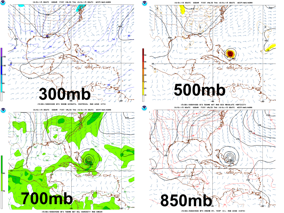
(Click on image for larger version)
Note how the ridge over the Yucatan/NW Caribbean is much more defined at 300mb and 500mb than it is at 700mb and 500mb; also note how the ridge northeast of Joaquin appears to be the dominating low level steering feature. This means that as Joaquin grew stronger over the last day and was influenced by a deeper steering flow, it felt more of a “tug” to the south by the upper level ridge to its west, resulting in the storm moving more southwest over the last day as opposed to west or WSW. This makes a big difference by Friday and Saturday when potential interaction with the SE US trough and a low east of Joaquin –partly associated with the remnants of Ida— occurs.
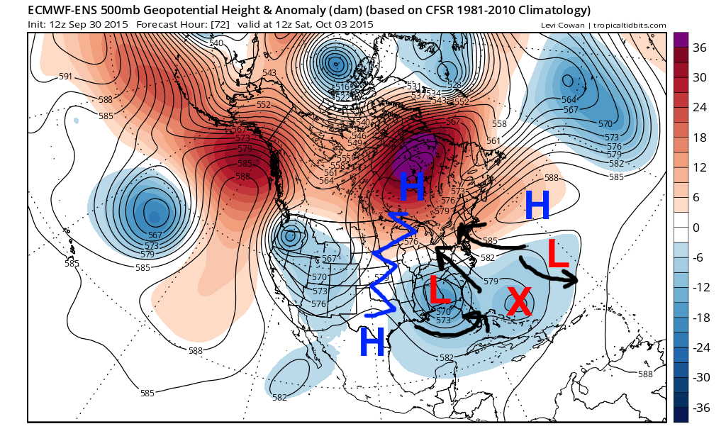
I want you to focus your attention to the 12z European ensemble 500mb mean height image above. A farther south Joaquin does a couple of different things:
- Joaquin is actually closer to the low to the east of the hurricane than the upper low over the SE US. The logic behind the US landfall would be that Joaquin would move north of the Bahamas and get caught in the large scale SSE steering flow off of the SE US coast and then Fujiwhara with the SE US upper low, causing the hurricane to sling northwest and towards the coast while the upper low dove east. If Joaquin is closer to the low to its east, it would be more likely to Fujiwhara with that low, causing Joaquin to actually get pulled more east, similar to what the Euro has been showing for nearly 3 days.
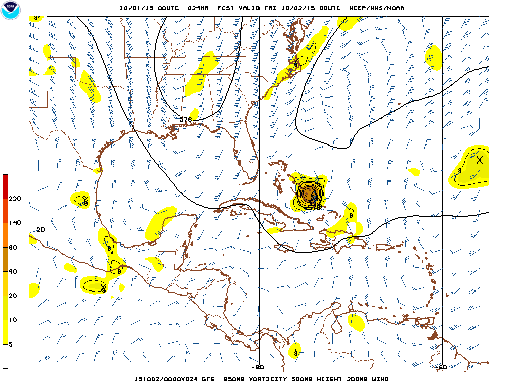
- As I pointed out yesterday, in order for the above to occur, it was imperative that Joaquin be north of the base of the SE US trough as it begins moving east Friday into Saturday. If Joaquin is along or south of the base of the trough, the winds around the trough push it east; if it’s north of the base of the trough, the winds pull it north. This can be seen well on the GFS image below; note how if Joaquin is any farther south than what the model has, the trough kicks it east:
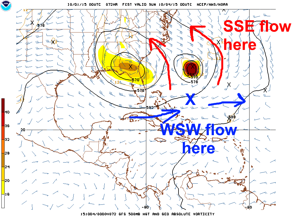
If Joaquin is even 100 miles south of the GFS forecast 3 days out, not at all a stretch and in fact close to the Euro and 0z UKMET, the winds around the trough have a TOTALLY different impact on the storm.
WITH THAT SAID, CAN A US EAST COAST LANDFALL STILL OCCUR?
YES, here’s how:
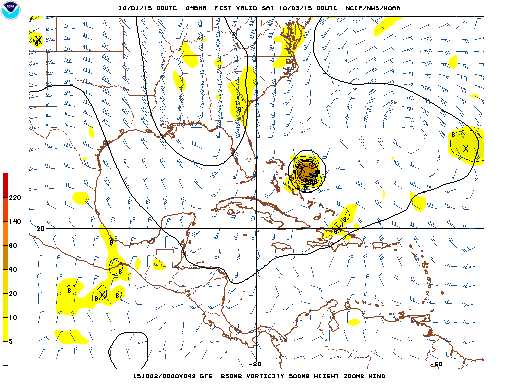
The upper level ridge west of Joaquin that has imparted a southwest motion on the hurricane over the last 24 hours is expected to weaken fairly soon, by Thursday afternoon/evening, as the upper level trough starts impinging on it from the north. Note how on the above GFS image valid 2:00PM Thursday, there anti-cyclone west of Joaquin appears to be smaller and weaker than it currently is. This should cause the current southwest motion to stop on Thursday. This may not be enough however; since Joaquin has tracked so much farther south than expected already, the upper trough, even in the above image, appears to want to cause a westerly steering flow near Joaquin, with the hurricane only near the edge of the east flow around the ridge to its NNE, all while the low associated partly with what’s left of Ida to the east attempting to move west and impart a more southeast motion on the hurricane. I’m starting to think that since Joaquin is farther south and won’t be drawn northward by the trough initially that although the SW motion may stop Thursday, it may stop only to result in a stall through Friday. By Friday, the trough is digging in, and if Joaquin can’t get north by then, the trough kicks it east, with some help from the low to the east of Joaquin as well. This type of scenario would stall Joaquin very near to or over the central Bahamas as a very powerful hurricane.
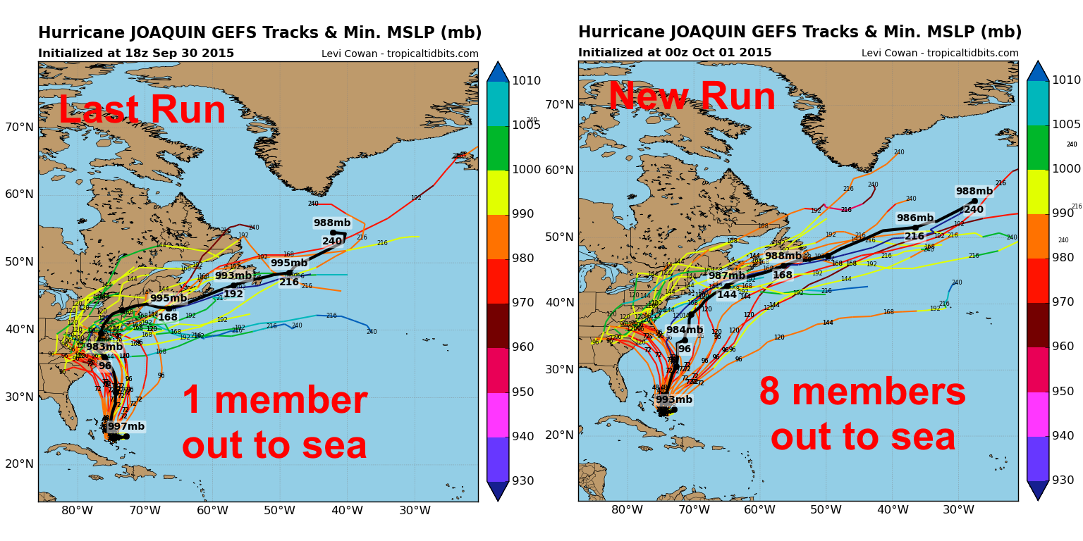
Overall, the more significant southward component of motion of Joaquin over the last day makes it harder for a binary interaction to occur between Joaquin and the SE US trough that would hook Joaquin towards the eastern seaboard. It still isn’t impossible that this occurs, however Joaquin would have to cease all southwest motion very soon and then find a way to move north, even though the steering flow may not allow that to easily happen. It is extremely important to note that for 3 days the European model has consistently shown an out to sea track; the European model has also consistently outperformed all other guidance in terms of moving Joaquin much farther southwest in the near term than expected by other models and frankly myself. The 12z European ensembles went from having a fair number of members still take Joaquin into the coast to only having about 15% of the ensemble members pull it off. Also, big changes have occurred over the last two runs of the GFS and Canadian ensembles, with many more members now taking Joaquin out to sea (despite the operational runs still taking Joaquin into the coast):
GFS ensembles:
Canadian ensembles:

You may be saying that a large majority of the Canadian ensembles still take Joaquin into land, which is certainly correct, however, the Canadian ensembles fail to accurately capture the current southwest motion, which is of the utmost importance as discussed above. The new GFS ensembles capture this movement more so than the 18z run, and respond in kind with many more members going out to sea. Unfortunately, unless the southwest motion stops immediately, the GFS ensembles still are botching the very near term forecast, meaning further adjustments will probably occur.
For my “deterministic” track forecast, based on everything discussed here, I have little choice but to take the track off the East Coast. Due to a still not impossible scenario that takes a hurricane towards the East Coast, the coast will be in my cone of uncertainty. For my actual track, I will blend the 0z GFS and Euro operational runs for the first 48 hours, and then blend the GEFS mean and 0z operational Euro. There’s a real possibility that further eastern shifts could be needed, however at this point I feel like this route allows me to firmly show I’m much less enthused about an east coast landfall while not biting 100% on the Euro. To an extent this is a “less wrong” approach, but still sends the message I intend, and is unfortunately a big change from my forecast yesterday.
As a note, potentially flooding rain from a PRE well west of Joaquin and minor to moderate coastal flooding due to a strong pressure gradient well north of Joaquin are still expected across parts of the SE US and Mid-Atlantic, mainly Friday-Sunday.
Forecast Map:
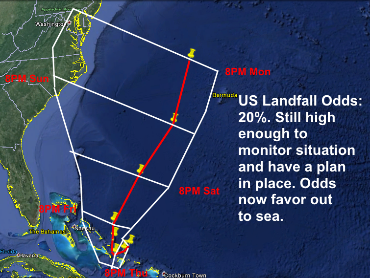
Location coordinates and intensity:
2:00AM Thursday…23.5N, 73.4W…105kt
8:00AM Thursday…23.2N, 73.9W…105kt
8:00PM Thursday…23.0N, 74.3W…120kt
8:00AM Friday…24.1N, 74.5W…120kt
8:00PM Friday…25.1N, 74.4W…120kt
8:00PM Saturday…28N, 72W…105kt
8:00PM Sunday…31.0N, 69.0W…85kt
8:00PM Monday…35N, 67W…70kt
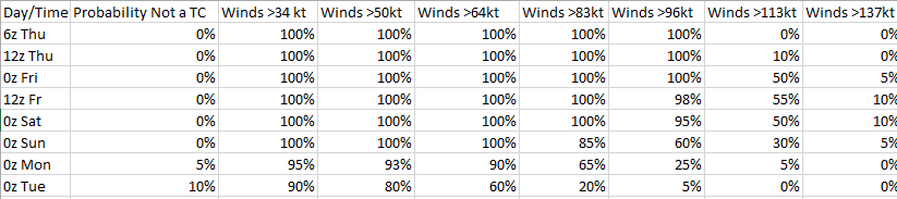
Intensity probability table: