
Just some quick thoughts before I head out for the night…
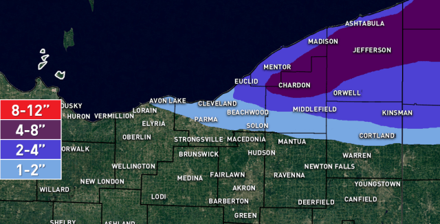
Winds will be WNW, however, am concerned the ice near the southern shore and also over the western basin extending into the central basin may allow the shoreline convergence to occur a little farther north closer to the remaining open water. Ice coverage over the western basin is now over 90% with a thickness of 6-12″+, which is thick enough to be more prohibitive of good heat/moisture flux. So, will cut off the snow farther northeast than I would for this type of flow with an open lake. Still, with some moisture flux and a good fetch from Lake Michigan aimed towards the Cleveland area, was nervous enough to include an inch or two for the Cleveland metro and expand the 2-4″ a bit farther SW than the hi-res models suggest.
With a well-aligned WNW flow from early Monday AM through the evening before the winds start backing and pushing the snow up the shoreline, will be a 12 or so hour window of good snow. Parameters are OK with EL heights near 8k feet and moderate instability. The airmass is quite dry but Lake Michigan pre-conditioning and reasonably light/well-aligned winds will make up for that a bit. The NAM shows super-saturation with respect to ice in the upper half of the very shallow dendritic growth zone and upward motion in the DGZ, so if the NAM doesn’t bust too high with its dew points there should still be enough snow growth for decent ratios, though the airmass is quite cold and it’s close, if dew points are lower than the NAM ratios may struggle outside of any stronger bnd. Given OK instability and a good WNW fetch without a ton of movement for around 12 hours, will go with 4-8″ in the northern primary Snowbelt. There may be a convergence band possibly from NE Cuyahoga into southern Lake/northern Geauga/Ashtabula caused by the interface between mostly ice-covered and thicker ice and open water pushing the convergence a bit north of the shoreline. Where any more dominant bands develop over NE OH/NW PA will be where the best shot at closer to 8″ will be. Think there will be a band that develops over the northern Snowbelt from Lake/Ashtabula/Erie Counties early Monday ahead of a vort max that then swings SW as winds go WNW by later morning. The band will likely lift NE Monday night then push over the lake by Tuesday. Could see a locally higher amount in Erie County as they’ll have a longer window for snow through Monday night than NE OH.
Happy New Year!
