

General discussion (scroll down for technical thoughts):
Snow showers will generally diminish tonight as they move east across Ohio. An exception will be downwind of Lake Erie, where some light accumulations may occur.
Snow showers will ramp up Tuesday state-wide, with brief but intense snow showers possible, especially during the afternoon and evening. The best shot for some light accumulations during the day Tuesday will be in the higher terrain from north-central Ohio east through northeast Ohio, though in most cases any quick snow accumulations from the snow showers will melt between snow showers. The most likely exception may be the Snowbelt in northeast Ohio due to some lake enhancement in the morning that could drop up to a couple of inches. The concern during the day Tuesday will be brief periods of significantly reduced visibility and snowy roads with the heavier snow showers causing hazardous travel conditions.
As the sun goes down Tuesday evening any lingering intense snow showers may have a better shot at producing a quick accumulation anywhere in the state. Lingering moisture on roads may freeze. A burst of heavy lake effect snow is expected Tuesday evening, producing a quick 1-3″ of accumulation in both the primary and secondary Snowbelt, including the Cleveland area. This may create a period of hazardous travel during or just after the evening commute.
After perhaps a brief lull late Tuesday evening, another increase in lake enhanced snow may occur late Tuesday night into Wednesday morning in northeast Ohio. Depending on how heavy this burst of snow is, it may adversely impact the Wednesday morning commute from Cleveland and perhaps Akron points east before the snow winds down by noon Wednesday.
Technical discussion:
Complicated setup over the next couple of days, but there will be rounds of snow with accumulations likely.
A shortwave/weak surface low going by this afternoon is causing some flurries and light snow with no real accumulations with temps above freezing. Tonight this wave and lift pull off to the east, but a relatively unstable airmass currently over lower MI/IN/NW OH will drift east across the lake tonight. Though the snow showers over lower MI are largely diurnally driven, the steep low-level lapse rates and good moisture will slide east. Mixing over the low to mid 30s water of Lake Erie should cause this airmass to produce light to briefly moderate lake effect snow showers this evening into tonight across parts of NE OH and NW PA as the corridor of moist/unstable low-level air slides east. The RAP forecast soundings have good moisture/lapse rates up to 7-8k feet at CLE as this airmass moves overhead this evening with NW winds. The NAM soundings are drier/more stable, but have generally found that an airmass that produces widespread diurnal snow showers overland will produce some lake response as the diurnal snow showers over land decrease. With a NW flow expect the higher terrain from the secondary Snowbelt south of CLE east across the primary NE OH Snowbelt and interior NW PA to have the best shot at some accumulations tonight. Duration of favorable conditions is only a few hours in any given area and organization doesn’t look great, but the layer of instability appears deep enough for moderate bursts. Tend to think a dusting to up to an inch or inch and a half is likely tonight downwind of the lake, with the best shot at around an inch or so in the higher terrain.
Perhaps a brief lull late tonight before the next potent shortwave/vort max passes late Tuesday morning. The strongest lift from this vort max may track a little southwest of the Cleveland area and NE OH, however, some increased lift along with a lobe of upstream moisture and the layer of instability deepening to over 10k feet should allow for a decent period of snow showers Tuesday morning with this feature. Some models take the upstream moisture towards the central highlands in this period, but with a NW or NNW flow I don’t buy the Lake Huron moisture moving that far southwest. Think it will affect the Cleveland area and perhaps secondary Snowbelt, and the rest of NE OH. The best snow in this period may miss NW PA to the west, but some increase is possible in this area. Some bursts could put down a quick inch or two of snow Tuesday morning downwind of Lake Erie in NE OH as the vort max goes by, however, again a lack of organization and fairly short duration, along with known difficulties accumulating during the day this late on the year, hard to get excited about much more. Outside of the Snowbelt, expect to see diurnal snow showers that are briefly heavy pop up. Best shot at some light accumulations outside of the lake effect may be in the central highlands where upslope may focus snow showers a bit more and where temps will be a couple of degrees cooler. Anyone could see a quick/likely brief dusting though Tuesday as the snow showers ramp up overland.
Any more organized LES by Tuesday afternoon will likely break up, however, with remarkably cold 500mb temps of around -40C expect numerous convective snow showers to continue across much of the state Tuesday afternoon. The snow showers will be briefly heavy and may quickly produce a dusting where they track. In the higher terrain, there may be somewhat better odds at enough snow showers during the afternoon for a little additional accumulation, though normally this time of year any accumulations from these convective snow showers melt pretty quickly between showers. Temps outside of perhaps the higher terrain in north-central and northeastern OH/NW PA where it will be close to freezing will be in the mid to upper 30s between snow showers. The main concern with the diurnal convective snow showers will be visibility reductions and perhaps briefly slick roads.
A sharp surface trough drops across the lake into north-central and NE OH Tuesday evening. The models have shown this feature for several runs and it appears to be tied to a vort max at 700mb rotating around the western edge of the trough. The vort max may cause a further intensification of the diurnal snow showers late Tuesday afternoon from western OH to SE OH, and as the sun goes down any lingering intense snow showers could drop a quick half inch or inch before weakening overnight with the loss of daytime heating. The big concern will remain significant visibility reductions and brief slick roads. Downwind of Lake Erie, the sharp surface trough when combined with soundings showing instability and moisture to over 13k feet will likely result in a brief but intense period of squalls during the evening. Moisture from Lake Huron again looks to work into NE OH with this feature. Some global models bring the Lake Huron moisture towards Mansfield again in this timeframe, but with a NW to NNW flow will again side with the hi-res NAM and RGEM that drop the Lake Huron moisture into the Cleveland area and surrounding Snowbelts. With this burst occurring near or after sundown it should accumulate downwind of Lake Erie. The best may again be in NE OH as opposed to NW PA in this timeframe given closer proximity to the mid-level vort max and track of the upstream moisture. Organization (lack thereof) and short duration will probably limit amounts, but given the very deep instability and sharp nature of the trough, a quick dusting to locally 3” is possible downwind of Lake Erie Tuesday evening, especially in the higher terrain where it’ll be a little colder and where precip amounts will be maximized. This may cause a period of hazardous travel conditions.
Another little shortwave/spoke of synoptic moisture/lift drops through Wednesday morning. Some disagreement to how far west this gets. NW PA looks like a good bet, and many models do at least hit the primary NE OH Snowbelt. Cleveland area is iffier, though the 18z NAM and RGEM do get a burst of snow as far west as the secondary Snowbelt. With decent looking snow ratios, a favorable WNW to NW upslope flow, duration of perhaps several hours in NW PA, and enough low-level instability for decent lake enhancement, this may produce decent accumulations. Snow rates of an inch per hour may occur in the higher terrain. Will expect 3-6” in interior NW PA, 2-4” in the higher terrain in the primary NE OH Snowbelt, and 1-2” in the higher terrain of the secondary NE OH Snowbelt late Tuesday night-Wednesday morning. This is all dependent on how far west the lobe of synoptic moisture/lift gets, which is uncertain. Adjustments up or down are possible. Should be a decent lull Wednesday afternoon through early Thursday between systems.
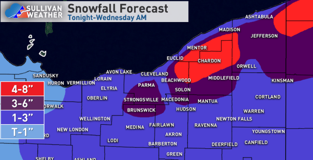
For total accums…in the higher terrain in the primary NE OH Snowbelt, am going around 1” tonight, 0.5-2” Tuesday morning, less than 0.5” Tuesday afternoon, 1-3” Tuesday evening, and 2-4” late Tuesday night/Wednesday morning for 4.5-10.5” (will call it 4-8” for now). Some melting may occur during the day Tuesday between snow showers. In the secondary Snowbelt am figuring 0.5 to 1” tonight, 0.5-2” Tuesday morning, less than 0.5” Tuesday afternoon, 1-3” Tuesday evening, and 1-2” late Tuesday night/Wednesday morning for about 3-6” total. For NW PA am thinking 4-8” in the higher terrain, as the snow through Tuesday evening may not be that impressive there, but that will likely be made up for late Tuesday night/early Wednesday. Some models have more QPF there Wednesday morning, so that will have to be watched. Will also drag 1-3” into the central highlands and also the rest of NE OH south of the Snowbelt due to decent bursts of snow working south from the lake, especially Tuesday evening. Do think all of OH is at risk for some quick bursts of snow producing a dusting Tuesday into Tuesday evening. With a short fetch off the lake and milder temps near the water, am expected a good bit less snow near the lakeshore than in the higher terrain inland.
The period between late Tuesday PM and Wednesday AM may prompt some advisories in NW PA and perhaps the higher terrain of the NE OH Snowbelts. If the wetter solutions pan out for early Wednesday inland Erie County could flirt with needing a warning.
