

Categorical Severe Weather Outlook for Tuesday and Tuesday night from the Storm Prediction Center issued Monday afternoon

Threat levels for the individual severe hazards for Tuesday-Tuesday evening across Ohio
We literally just wrapped up a winter storm that dropped up to 6” of snow on parts of Ohio 12 hours before this writing. Now we have to turn around and discuss a fairly interesting severe weather threat for tomorrow. Spring is quite a bitch in Ohio, ain’t it?

Forecast weather map valid 8:00PM Tuesday
This severe weather threat is being driven by a fairly strong area of low pressure that will track over extreme northwest Ohio Tuesday evening. This will push a warm front through much of the state during the morning and afternoon on Tuesday with one potential round of storms. A cold front will sweep through during the evening with a second and likely more potent round of storms.
ROUND 1: STORMS NORTH OF THE WARM FRONT EARLY TUESDAY:

Model forecast radar valid 8AM Tuesday
Storms are expected to flare-up north of the warm front late tonight and Tuesday morning. Much of the state will probably see some rain and perhaps some thunder Tuesday morning, but the most robust storms will likely be south of I-70. A quick 1-2” of rain may cause some flooding concerns with this round of storms in parts of central and southern Ohio. A few stronger storms may also produce some hail.
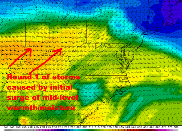
Model forecast mid-level temperature/moisture and wind valid 8AM Tuesday
This round of storms will be triggered by a surge of mid-level warmth and humidity that will ride up and over the surface warm front Tuesday morning. This will cause the unstable air to rise and generate thunderstorms, and is a classic way to get storms just on the “cold side” of a warm front. Most models show the storms and the conceptual model fits what the models show, so I’m inclined to expect a pretty good round of storms early Tuesday across southern and perhaps central Ohio.

Model forecast instability and wind shear valid 8AM Tuesday
There will be a fair amount of instability aloft and wind shear feeding into the early-day storms on Tuesday. Because of this, some stronger storms with hail will be a concern across southern and central Ohio early Tuesday. This isn’t really the meat of the severe threat, but given the ingredients in place early Tuesday, don’t be surprised if a few severe thunderstorm warnings are issued for quarter sized hail south of I-70 Tuesday morning.
ROUND 2: STORMS ALONG AND AHEAD OF THE COLD FRONT LATE TUESDAY-TUESDAY EVENING:
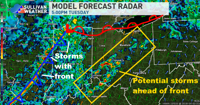
Model forecast radar valid 5PM Tuesday
After perhaps a lull early Tuesday afternoon, more storms will either develop or move in during the mid to late afternoon. We will watch for two areas of storms: a few storms potentially developing well ahead of the cold front over parts of Ohio during the mid afternoon to early evening timeframe, and then more widespread storms developing to our west closer to the cold front and sweeping across the state during the evening.
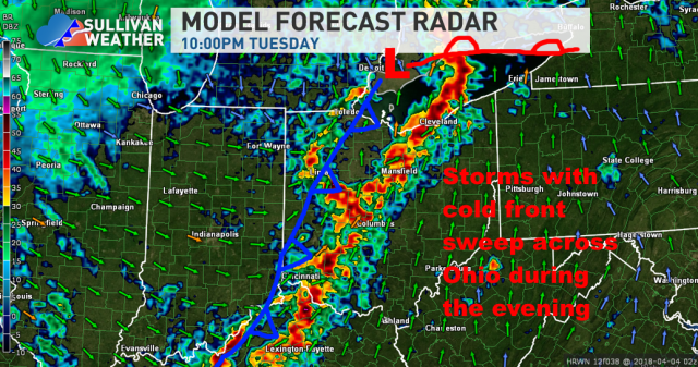
Model forecast radar valid 10PM Tuesday
The most widespread storms are expected to push across the state during the evening hours on Tuesday along and just ahead of the cold front. The storms will have their highest severe risk across parts of western and central Ohio, with a gradual weakening as they track farther east during the evening and head into some weaker instability.
All modes of severe weather will be at least somewhat possible with this second round of storms. I will address the environment for both the potential storms ahead of the front during the mid-afternoon to early evening timeframe and then the storms along the front itself during the evening.
POTENTIAL PRE-FRONTAL STORMS:

Model forecast instability valid 8PM Tuesday
There is some uncertainty regarding exactly how unstable we get by late Tuesday afternoon and evening, as it’s possible that the early rain and storms are stubborn to move out and keep some sort of a lid on things. Most guidance clears this early activity early enough to develop a moderate amount of instability by mid to late afternoon, so for now that’s the idea I’ll go with. If this idea works out, instability or a lack thereof won’t be a limiting factor Tuesday afternoon and evening for any storms ahead of the front or along it.
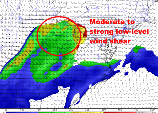
Model forecast low-level wind shear valid 8PM Tuesday
Thanks to the strong low pressure in the region, winds throughout the atmosphere will be fairly strong and will turn enough to generate a fair amount of wind shear. While the low-level shear values don’t necessarily max out the color scale in Ohio Tuesday afternoon and evening, values of over 150 are considered sufficient for rotating storms and an elevated tornado threat. All of Ohio looks to see values near or safely over that threshold, so though there could be some more shear, it also isn’t going to be a limiting factor for the severe threat.

Model forecast mid-level temperature change rate valid 5PM Tuesday
Another factor, in addition to raw instability, is how quickly temperatures cool in the mid-levels of the atmosphere. This determines how sustained any taller thunderstorms may be, and also the hail threat. We’re again not maxing out the scale here, but values of this index (called “lapse rates”) are high enough to support deeper thunderstorms and an elevated risk for large hail with any individual storms ahead of the cold front Tuesday afternoon and early evening.
If individual storms can develop and sustain themselves ahead of the cold front in this moderate instability and moderate to strong wind shear environment, they would have a threat for large hail, strong winds, and even tornadoes. Will they fire? That’s sort of up in the air.

Model forecast cap strength valid 5PM Tuesday
There will only be a weak cap ahead of the cold front. This means it will be fairly easy for storms to fire in this environment. IF the early day storms don’t linger and keep temperatures cooler, it appears that a cap won’t limit any storm development ahead of the cold front.
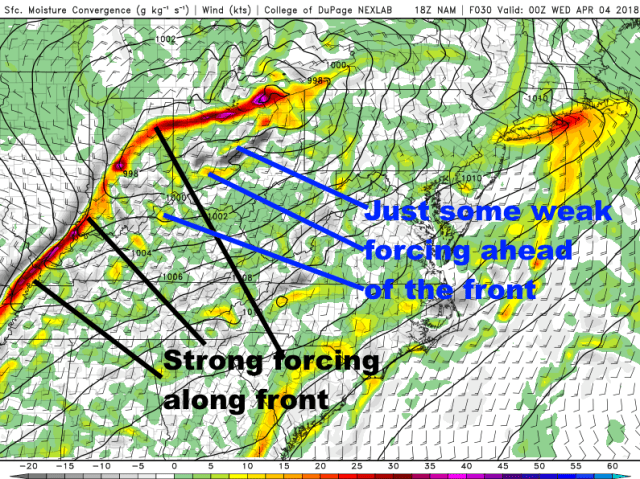
Model forecast low-level lift valid 8PM Tuesday
Even with the weak cap, we still need a little bit of “oomph” to get storms to go ahead of the front. The forcing along the front is clearly strong, ahead of the front it’s non-zero but also fairly weak. My hunch is this may allow isolated storms to go ahead of the front late Tuesday afternoon and evening.
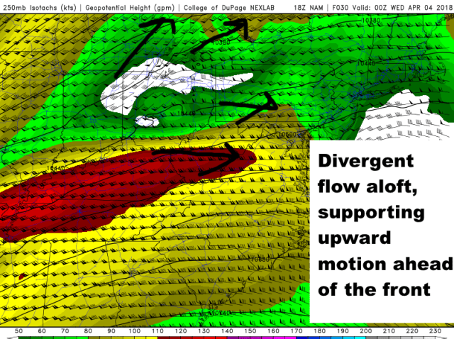
Model forecast upper-level winds valid 8PM Tuesday
The upper-level flow will be broadly divergent over Ohio, with a favorable quadrant of a “jet streak” (region of stronger winds in the jet stream) for large-scale lift also near Ohio. This, along with the weak cap and weak but non-zero low-level forcing ahead of the front, should be enough for some isolated storms ahead of the cold front mid Tuesday afternoon through early evening. The weak nature of the low-level forcing may keep the storms isolated and discrete, potentially increasing the threat for them to turn severe with some large hail and perhaps produce tornadoes. With that said, the low-level forcing is weak, and if temperatures a bit cooler at the surface then the cap will be stronger, so this is still a conditional threat for rotating/severe storms. But, I see enough ingredients in place to tentatively raise some alarms.
AS FOR STORMS ON THE FRONT:

Model forecast instability and cap strength valid 11PM Tuesday
Strong forcing along the front will force storms to fire over Indiana late Tuesday afternoon and move into western Ohio by early evening. Favorable parameters as discussed above will be in place as the storms hit western Ohio, meaning some will likely be severe. These storms will not be “discrete,” but will be messier and perhaps organized into lines. This will tend to limit the potential for large hail and tornadoes, but may increase the potential for damaging winds. So, the expectation is a somewhat organized line of storms will get into western Ohio between 6pm and 9pm with mainly a damaging wind threat…though isolated hail and a spin-up tornado can’t be ruled out due to the amount of instability and low-level wind shear in place.
As the storms move east, low-level temperatures will slowly cool through the evening, causing instability to slowly weaken and causing the cap to slowly re-develop. This will cause the storms to slowly weaken as they head east across Ohio, though an isolated severe storm or two with mainly a damaging wind threat may make it all the way into eastern Ohio given the strong lift with the front and wind shear in place.
All in all, we have a fairly dynamic setup for Tuesday and Tuesday evening, though how storms ahead of the front play out will determine the ultimate threat. The early-day storms will modulate future instability…they need to clear quickly enough for a substantial threat later in the day. That’s currently the expected outcome, but it’s never a given. Whether or not isolated storms develop ahead of the front with a severe risk is a bit uncertain, and a messy storm mode with storms along the cold front itself may put somewhat of a lid on that threat. Regardless, given the ingredients in place, locations in the risk area from the Storm Prediction Center in Ohio will need to have their eye on the weather Tuesday into Tuesday night.
