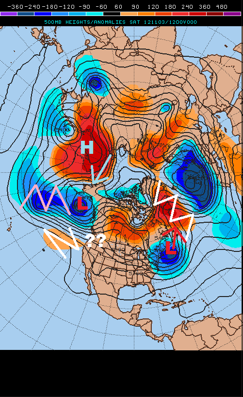
A current look at the upper level pattern across our hemisphere shows that significant blocking is still occurring, with several of our models developing a significant east coast storm for the middle of next week due to this blocking. Let’s talk about some of the highlights on the current map, posted above:
- Strong –NAO blocking remains in place over Greenland. A large trough of low pressure, partly associated with the remnants of Hurricane Sandy is located over the northeast US and is drifting northeast. The block will pin this feature near Newfoundland, allowing it to act as a blocking “50/50” low.
- Strong ridge of high pressure over northeast Asia is forcing a deep upper level low pressure over the Gulf of Alaska. This feature is expected to persist.
- The upper low over the Gulf of Alaska is attempting to dig south, resulting in ridging to the east of it.
- The flow off the Pacific into the northwest US is still extremely fast and flat. Will the amplifying Gulf of Alaska low pressure allow ridging to build over the western US, making it easier for the pattern to buckle over the eastern US in a few days?
As we take a look at the GFS and European ensemble means, valid Monday morning, we see this anticipated pattern taking hold. The Upper low currently over the northeast is slowly drifting north, while the Gulf of Alaska upper low/trough is amplifying ridge over the western US. The NAO remains negative, and this supports a trough over the eastern US.
At this point however, the upper low north of New England prohibits shortwaves from taking on a negative tilt until they are well off the east coast, meaning they don’t spin up a storm. However, there are two “new” shortwaves, circled on the above image, diving down into the newly amplified eastern US trough.
As we roll the ensembles out to Wednesday morning, we see that a significant trough is shown over the eastern US. –NAO blocking and a 50/50 low are clearly in place on both models…the PNA is quickly going negative on both of the ensembles at this point, however neither model allows the strong Pacific flow to overtake the western ridging before this point in time. The result is a very strong negatively tilted trough over the eastern US, with a clear storm signal off the Mid-Atlantic coast on Wednesday.
When taking a look down at what the two sets up ensembles show at the surface Wednesday morning, both ensemble means are in good agreement on a deepening area of flow pressure off the southeast US coast, with some cold air in place over the northeastern US and interior Mid Atlantic. This matches what the 500mb plots shown two images up imply.
When rolling the surface comparison forward to Thursday morning, one can see that while the ensembles are in similar agreement in tracking a moderately strong Nor’ Easter up the east coast Wednesday through Thursday, they are not quite in agreement on track. The GFS ensembles in the top right are a bit farther northeast than the Euro ensembles and a bit faster. The GFS ensemble mean is also several MB deeper with the low pressure than the Euro ensembles, indicating potentially less disagreement between ensemble members than the Euro ensembles.
A look at the individual GFS ensembles members valid Thursday morning however shows some significant disagreements between members. Several members take the low west towards NY state, while others slide farther out to sea. Several are also near the ensemble mean.
When trying to determine which solution is the better solution, one must look at the pieces that are anticipated to come together for a storm:
When looking at the GFS valid Tuesday morning, a day before the coastal storm is expected to begin deepening, one can see two significant pieces of energy in the eastern US trough. One is a sharp shortwave over AL/GA, another is a very potent system diving into the Upper Midwest.
As we roll out the GFS prediction another day to Wednesday morning, one can see that the initial shortwave has taken on a negative tilt, along with the whole trough, off the southeast coast, resulting in surface low pressure formation. The model is also showing the potent energy rounding the base of the trough and attempting to phase with the energy off the southeast US coast.
By Wednesday evening, the GFS has completely phased the two pieces of energy, resulting in a deep upper level closed low (and sfc low pressure) on the Mid Atlantic coast. However, the model is also completely smashing western US ridging by this point and has broken down the –NAO.
When comparing this to the other operational models, we note some similarities and differences:
- All four models have broken down the –NAO/50-50 low combination, with a thin strip of ridging extending into Northeast Canada.
- The models have all weakened western US ridging, but not to the same extent. The GFS model and Canadian models appear to be the flattest with the western US pattern at this point, and these two models have the weakest –PNA/Alaskan ridging at this point.
- All the models do have a storm near the east coast of the US at this point. The GFS is farthest west, over southern New England, while the Canadian and UKMET are similar in track, just south of Cape Cod. The Euro is farther southwest but likely wouldn’t track as far west as the GFS after this.
Thus, there seem to be a few things that dictate the track of the low pressure system:
- When the two pieces of energy phase. Is it off the southeast coast? Off the Mid-Atlantic coast? Off the New England coast? A later phase results in a track farther southeast.
- How quickly western US ridging breaks down. A quicker breakdown likely results in a track farther off the coast.
- How quickly does the negative NAO break down? If it breaks down quicker, the storm will be able to hook farther NW after phasing. A slower break down suppresses the track farther east.
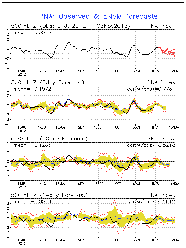
Given the PNA is currently only slightly positive and forecast to quickly go negative this week, I’d slightly favor a quicker break-down of western US ridging:
Given the NAO is currently negative but already trending positive, and the expectation of it to continue rising, I think the models are currently generally accurate in their depiction the weakening –NAO as the storm moves up the coast:
With all this said a track near the ensemble means, and closer to the Canadian/UKMET, likely near or just outside the 40/70 benchmark and continuing NNE just off the southern New England coast, seems most reasonable at this time. However, many models do show the trough becoming negatively tilted west of the Apps, which is a warning that some westward shift is possible, but not guaranteed. Regardless:
What this means:
-Enough cold air will likely remain in place for some snow in the inland Mid Atlantic. However, it is uncertain how much moisture is thrown well inland. It is also uncertain whether or not enough cold air is in place near the coast for significant snows, given the rising NAO and falling PNA.
-The low pressure system will likely deepen below 990mb, with a strong ridge of high pressure to the north. Although not nearly as strong as Sandy, this will be enough for gale or storm force winds blowing onshore over the Mid-Atlantic and New England Tuesday through Thursday. Moderate coastal flooding is possible in already hard hit areas. Some minor wind damage is also possible near the shore line.
I will have another update with specific impacts Sunday night or Monday morning.


