Above is a look at what has quickly become a relatively quiet weather pattern from the Plains east to end the work week. The reasons for this are relatively easy to pin point on the above map:
- Polar vortex over Greenland and Northern Canada combining with a strong vortex off the west coast of the US to tighten up the polar jet
- Troughing along the west coast forcing ridging over the eastern US, with the +NAO allowing the ridging to extend all the way to the east coast.
So, until this pattern buckles, the quiet weather will continue across the eastern 2/3rds of the US. Right now there are not any signs of this changing through much of next week.
As we take a look at the forecast telleconnections off last night’s GFS ensemble runs, we see some trends:
- The NAO will trend closer towards neutral. However, will it go negative?
- The AO shows wild variability. More on that in a moment.
- The PNA is expected to remain negative, meaning troughing will persist over the western US over the next 10-14 days. However, the trend was for the PNA to head towards neutral in 10-14 days, meaning the trough along the west coast may weaken into December.
To determine if these teleconnection forecasts are accurate, we are going to take a look at the tropical Pacific to determine what may happen down the road. You may be asking, why does the tropical Pacific, located nowhere near North America, affect me? Well, latent heat from convection over the Pacific modulates sub-tropical Pacific upper level ridging strength, which dictates where the Pacific jet sets up, which results in low level cyclones forming, which ultimately affects where troughs and ridge will be located over the eastern US. Let’s take a quick look at this now:
The strongest and most active convection in the tropics is occurring, per the above image, over the Indian Ocean at this time. This is resulting in stronger sub-tropical ridging over Asia, and results in the strongest jet-stream to be located over the western Pacific, as can be seen on this afternoon’s GFS model 250mb analysis:
Note the higher than normal heights associated with the ridging west of the dateline into southern Asia, and note below, how this accelerates the flow of the jet stream in this area:
This is important, because, as we discussed with Sandy, the jet streaks affect surface level cyclones in a big way. The left-exit and right-entrance portions of these upper level jet streaks feature upper level divergence and lift, which aids in strengthening lower level cyclones. Right now, the left exit portion of the above jet streak over the western Pacific is located over eastern Russia and the extreme northwest Pacific, meaning cyclones are favored in this area. The current surface analysis reveals this to be true:
This means that cyclones are continually pumping warmer sub-tropical air northward to their east, which happens to be over the Aleutian Islands. This means geopotential heights will be higher in these areas as the warmer air is more buoyant and rises, forcing the atmosphere to more or less become “thicker,” as we witnessed above with the higher heights occurring with the convection over the Indian Ocean, which also releases heat.
This is certainly the case in this instance, as upper level ridging is extending north to the east of all these surface cyclones, and the northerly flow on the east side of this ridging is forcing the west coast trough, ala a –PNA. The question is, when does this pattern change?
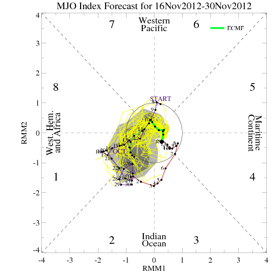
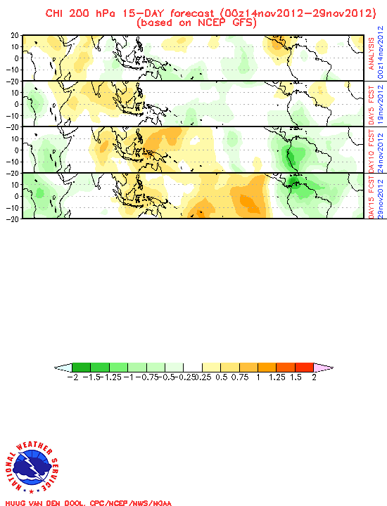
Above are plots of the GFS and ECM MJO phase forecast. Essentially, the MJO is relatively weak right now, however it is projected, per the models, to strengthen and move into the western Pacific and into our hemisphere, IE, east of where it is now, in a week to two weeks. Visually, the GFS brings the convection east of the dateline after Thanksgiving, as shown below:
The question is, is this MJO pulse plausible?
The GWO, which is a measure of Earth Atmospheric Angular Momentum, which essentially is the air in the atmosphere spinning to keep up with the Earth’s rotation, is undergoing a phase shift. Look below:
The GWO/AAM are going from “negative” phases to more positive ones. This is an indication that the configuration of upper level winds are changing, and shifting east. As one can see in the brief explanation graphic two images up, if the GWO/AAM continue to trend towards phases 5 and 6, convection near and east of the dateline will be favored, which would effectively dislodge the –PNA as discussed above. However, we still appear to be a couple weeks away from this happening.
There are a couple ways a –NAO event can occur. The first one is related, also, to what occurs over the tropical Pacific. If the convection associated with the MJO occurs east of the dateline, the configuration of the jet streaks does tend to focus surface cyclone-genesis over the eastern US resulting in higher heights extending towards Greenland/the NAO region. There are some subtle signs of this happening in a couple weeks, although no extremely strong signs yet that the MJO will become favorable for this.
The other way is if the stratosphere suddenly warms and the polar vortex is disrupted:
The most recent look at the lower portions of the stratosphere shows a relatively well organized but not terribly strong vortex. The upper levels of this vortex are much stronger. There are some signs that warming occurring over Asia will attempt to disrupt the vortex over the next week or so, with the Euro trying to show the vortex splitting in 9 days:
A split polar vortex allows for very cold air to plunge farther south and makes things more favorable for high-latitude blocking. However, the European and GFS both fail to disrupt the upper levels of the polar vortex over the next 10 days, meaning it is uncertain how much high latitude blocking will occur.
When putting this all together, there are a few things that seem apparent to me:
-The ridging near or just west of Alaska will allow very cold air to pile up in Canada over the next 7-14 days.
-The troughing on the west coast may weaken or even be replaced by ridging in 2-3 weeks.
-Although the models are trying to show the NAO again going negative in 10-14 days, there are mixed signals with regards to how that plays out, and that is a wild card with respect to whether storms to near the beginning of December track towards the Great Lakes or farther south/east, IE near or off the East Coast.
When comparing the GFS and European ensembles in 9.5 days, or next Sunday evening, there are some similarities and differences:
-The strong polar vortex is evident on both models.
-Strong Alaskan ridging persists on both models along with troughing along the western US coast.
-Although ridging is building south of Greenland on both models at this point, the NAO is still not negative on either model yet.
-The troughing along the west coast does support troughing near the east coast, but the pattern will likely be too fast still at this point to support a major storm threat. However, parting cold shots with some light snows/lake effect snows will begin becoming possible after November 25th as cold continues to build just north of the Canadian border.
The GFS ensembles, during the 11-15 day forecast period, do manage to develop a –NAO while maintaining Alaskan ridging and western US troughing. This means it will remain hard to get the pattern to buckle far enough west for a major storm for the central part of the country. However, if the NAO does in fact go negative, there may be some kind of storm threat to New England and the Northern Mid Atlantic the last few days of November.
If the MJO propagates as appears likely there may be a more substantial storm threat the first week of December. Whether Greenland ridging manages to develop or not will determine if this is a snow threat to the Ohio Valley/Great Lakes or to the Northeast/Mid Atlantic.
Enjoy the nice weather this weekend!


