The thoughts in this blog are mine and shouldn’t be used to make any important decisions.
You can find official forecasts from the hurricane center, along with watch/warning info, at www.nhc.noaa.gov

Tropical Storm Arthur has continued to gradually intensify on Wednesday off of the eastern coast of Florida, and has also begun to start gradually moving to the north. This evening’s infrared satellite presentation of Arthur shows that convection and outflow are still somewhat limited on the western side of Arthur. This has prevented an eyewall that has been occasionally noted to fail to completely close off, resulting in only a gradual intensification of Arthur. Outflow is good to the south and east of Arthur, and the southern and eastern eyewall have consistently had deep convection on Wednesday, so if Arthur can shake off the last little bit of northwesterly shear still affecting it, then a more significant intensification trend may commence. Arthur currently has maximum sustained winds of 70MPH with a minimum central pressure of 989MB per the National Hurricane Center (NHC), so any slight increase in intensity would make Arthur a hurricane.
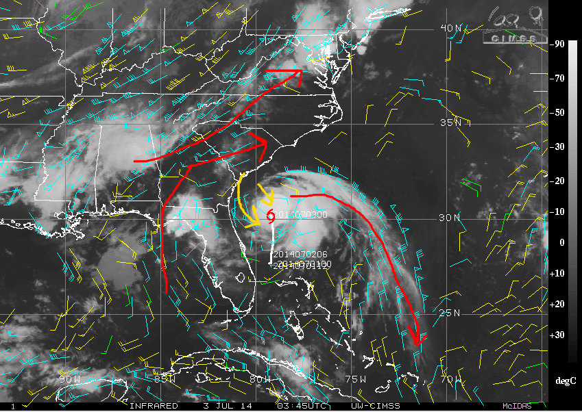
A look at the upper level winds surrounding Arthur show that there is a very strong equator-ward outflow channel, which essentially removes the air from above Arthur and promotes intense rising motion within the storm. However, there is still a little bit of northwesterly shear affecting Arthur. Although this shear is pretty weak, it is JUST enough to entrain some dry air from over the Carolinas into Arthur’s core, which has kept the storm from closing off an eyewall today. However, southwesterly winds associated with an incoming longway trough are beginning to approach Arthur, which will likely help cause outflow to develop on the pole-ward side of Arthur, eliminate the westerly shear, and give Arthur an opportunity to strengthen more significantly through early Friday.

A look at this evening’s GFS model valid Thursday evening shows that the model depicts a much better divergent flow over Arthur by Thursday evening. However, westerly winds would begin to approach levels that would shear the storm.
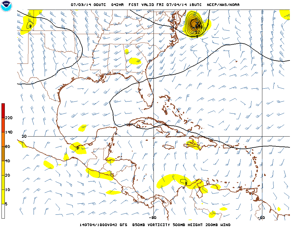
As we move forward to Friday afternoon, the GFS appears to show westerly winds beginning to make it through to the core of Arthur, which would likely begin a weakening and extra-tropical transition of the cyclone. This indicates that Arthur has between now and Friday morning to intensify before shear associated with the trough moving into the eastern US begins to become prohibitive. If Arthur moves over the Carolinas between now and Friday afternoon, that would obviously halt intensification sooner.
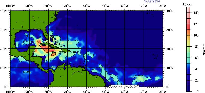
Sea surface temperatures between Arthur’s current location and the Outer Banks of the North Carolina are plenty warm for tropical cyclone intensification. However, the depth of the warm water is not extreme, as shown above. Arthur is a fairly small tropical cyclone right now, so as it begins to pick up speed over the next 12-24 hours this lack of deep warm waters may not hurt the cyclone. Essentially, once the current light northwesterly shear affecting Arthur weakens, warm enough waters given the circumstances and a favorable wind pattern in the upper levels of the cyclone favors strengthening into the day on Friday, assuming the storm doesn’t make landfall over the Carolinas before then.
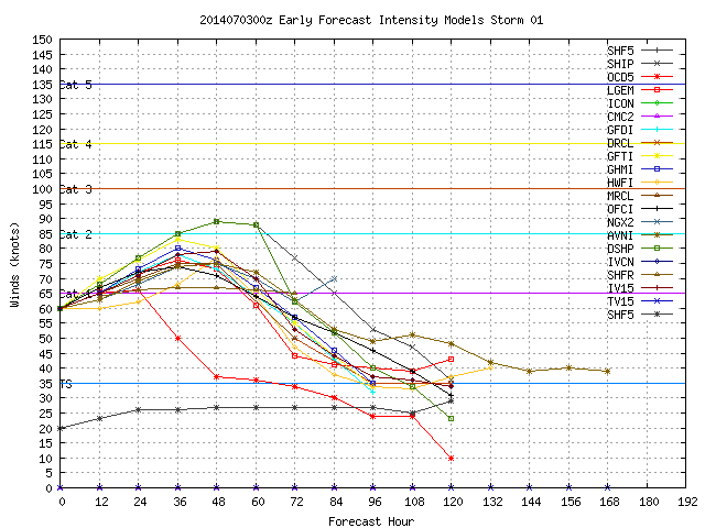
Given these seemingly favorable conditions for intensification, most of our tropical cyclone intensity models quickly make Arthur a hurricane at some point on Thursday…I think it will likely occur by the 11:00AM advisory from the NHC Thursday morning. Only the SHIPS model actually gets Arthur to category two intensity. However, I believe this may actually be a very possible if not likely solution, and not only because the SHIPS intensity model is statistically one of the best predictors of tropical cyclone intensity.

The above picture shows how high the cloud tops are in Arthur’s showers and thunderstorms, as seen from the Jacksonville, FL radar. Note how not only are there very tall thunderstorms in the northern eyewall, but how the radar is starting to pick up on some better convection trying to go up in the western eyewall of Arthur, which has had trouble closing off today. Also note how the eye is rather small, and how the bulk of the deepest convection is associated with the inner core/eyewall of Arthur.
When tropical cyclones have a small inner core, the energy associated with the cyclone is more focused there, and thus can cause the strongest part of the storm to strengthen significantly. Having a ring of deep convection around an eye in a tropical cyclone on microwave (or in this case radar) imagery is also a sign that a significant bought of intensification is getting ready to occur. Although the western eyewall of Arthur still needs a bit of work, if the weak shear from the northwest affecting the cyclone weakens by Thursday morning as expected by most models, then the eyewall would likely close off and the storm would likely deepen. It is possible that Arthur can quickly intensify to category two or even category three intensity by Thursday night or Friday morning if it could ever close off its eyewall.
It’s a tough call as to whether or not Arthur can pull off this rapid intensification over the next day or so. Most signals say yes, it’s possible, but it’s hard as a forecaster to forecast such a rapid intensification before it starts happening, especially when most of our forecast models don’t show this much intensification. It’ll be an interesting next 24 hours. In my post on Tuesday I said I expected Arthur to max out as a borderline category one/two hurricane (max winds 90-100MPH)…I still think that’s a good range, but there’s a bit of upside if all goes “well.”
How Close Will This Come to the Carolinas? What About Farther up the East Coast?

Arthur is currently moving to the north at 8MPH. The cyclone is about as close as it can currently get to the Carolina coastline without bringing some impacts to the region. Arthur is currently nestled between a sub-tropical high pressure centered south of Bermuda and a longwave trough moving east out of the central US towards the eastern US. As can be seen on the above image, there is a belt of strong southwesterly winds ahead of the trough over the central US that will begin to accelerate Arthur to the northeast by Thursday afternoon. Unfortunately, this puts Arthur on a path that parallels the North Carolina coastline and possibly brings it over land, especially the Outer Banks. In my last two blog entries on Arthur I mentioned that the orientation of the trough over the central US may cause the western side of the potential track—IE one that brought it very close to or over the eastern North Carolina coastline—to win out. As of this writing, that possibility is a very strong one.
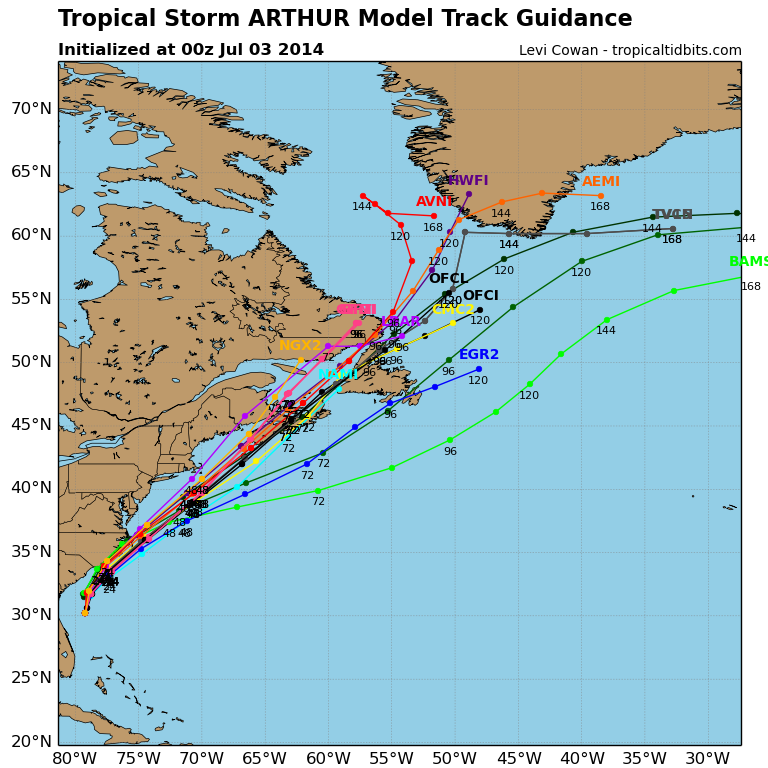
Most of our hurricane models now show Arthur coming within 20-50 miles of the North Carolina coastline from Wilmington points east, with about half of the models showing a track over or even inside of the Outer Banks. Note how yesterday, all of these models (barely) kept Arthur off shore.
Our two top performing “global” models, the GFS and Euro, both show similar tracks, with a graze job for a lot of coastal North Carolina (especially from Wilmington points east) and a direct impact on the Outer Banks. The GFS ensembles are in general a bit farther west than the hurricane models shown above, with almost all members tracking Arthur over or inside of the Outer Banks:

The European ensemble mean from this afternoon continues to show the mean position of Arthur among all of the ensemble members to be over the Outer Banks on Friday morning, which is a bit of a compromise between the hurricane models and GFS ensembles:

Given that this slight westward adjustment yesterday makes sense because of the PATTERN, I believe that it is legitimate. Thus, I believe it is likely that Arthur makes direct landfall somewhere along the North Carolina coastline…likely somewhere over the Outer Banks. It is important to note that areas as far west as the South/North Carolina boarder may see fair impacts along the coastline. The timing of impacts will be Thursday afternoon through Friday morning. A storm surge will likely occur over the Outer Banks, and may occur farther west along the coastline. A modest water rise could occur as far north as the Delmarva Peninsula. Winds may be strong enough to cause scattered to numerous power outages across a good portion of coastal and eastern North Carolina, and may be strong enough to cause notable structural damage in the Outer Banks. A few power outages may occur in eastern coastal South Carolina, much of eastern North Carolina (away from the coast) and far southeast Virginia. It is important to listen to advice from local authorities and heed all evacuation orders if issued for your area. If you are traveling to the Carolinas for the holiday weekend, especially eastern North Carolina, check ahead in case Arthur impacts your destination.

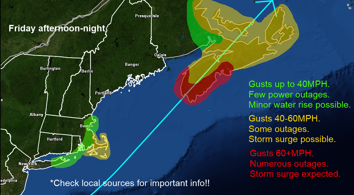
A look at the large scale weather pattern for Friday morning, per the European ensembles, shows that the trough approaching the eastern US is still west of Arthur, and has a neutral tilt. This suggests that Arthur may not be shunned as far east as initially expected. Some rain may affect parts of New Jersey, Long Island, and New England late Friday and Friday night in association with Arthur. In addition, tropical storm force winds may affect Long Island and extreme southeastern New England (Cape Cod, Martha’s Vineyard, Nantucket) as Arthur goes by Friday into Friday night. While the trough is expected to come in just in time to avoid a direct impact on any of these areas, some inconveniences are appearing more likely.
Here is where I think the greatest threat in the Carolinas is:

Note that a small shift west or east in the track has impact implications. Please stay on top of this by following local news sources in that region. Impacts begin Thursday afternoon.
Here’s where I think impacts are most likely in the Northeast: