In yesterday’s post about (then) Invest 91L, I discussed what would need to occur for what is now known as Tropical Storm Arthur to potentially intensify to hurricane intensity later this week. It is looking very likely that this will happen, and some impacts will be felt across the southeastern US through Friday. Let’s take a look at what Arthur is doing now, what may cause it to intensify, and areas that may see impacts. Remember that these thoughts are just mine and shouldn’t be used for any important decisions.
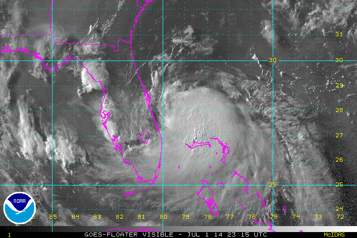
In stark contrast to yesterday, Tropical Storm Arthur’s satellite presentation actually has some good characteristics. There is a much larger, more organized area of deep convection that isn’t as displaced to the southeast of the surface circulation as it was yesterday. There is a bit more convection north of the center of circulation. Cirrus outflow has improved considerably in the southern semi-circle, and is attempting to develop in the northern semi-circle. This all points to Arthur becoming better organized and intensifying.

A look at recent radar imagery however suggests that we may have to wait a little while before Arthur intensifies notably. Yesterday I discussed the potential for the surface circulation to re-develop closer to the convection associated with the mid-level vortex (the vortex has been tilted to the southeast due to northwesterly shear). That appears to be happening, however that is not an instantaneous process. It takes a while for the old center of circulation to “spin down.” Regardless, the old surface center and the convection associated with the mid-level vortex appear to be rotating around a common point. In their 5PM EDT advisory, the NHC appeared to go with the common point for the current location of Arthur. Radar loops reveal that the old surface center is currently moving southwest (and becoming less defined), while the mid-level vortex (and potential location of the next surface center assuming shear does not continue to tilt the vortex) is moving to the north-northwest. This rotation suggests that a new low-level circulation is developing beneath the mid-level circulation, which would explain why the old surface center is rotating around a common point with the mid-level center and stronger convection.

A look at the upper level environment around Arthur suggests that once this center relocation completes and the vortex becomes vertically stacked, it should remain stacked and intensify. An upper level anti-cyclone that yesterday was located west of Arthur and inducing northwesterly shear has moved east today and is now essentially centered over Arthur. Shear analysis (yellow lines) shows less than 10 knots of wind shear over Arthur, which is favorable for intensification. Also note, the wind barbs representing the upper levels of the atmosphere are moving away from Arthur. This verifies the satellite appearance showing improved outflow, and promotes continued deep convection.
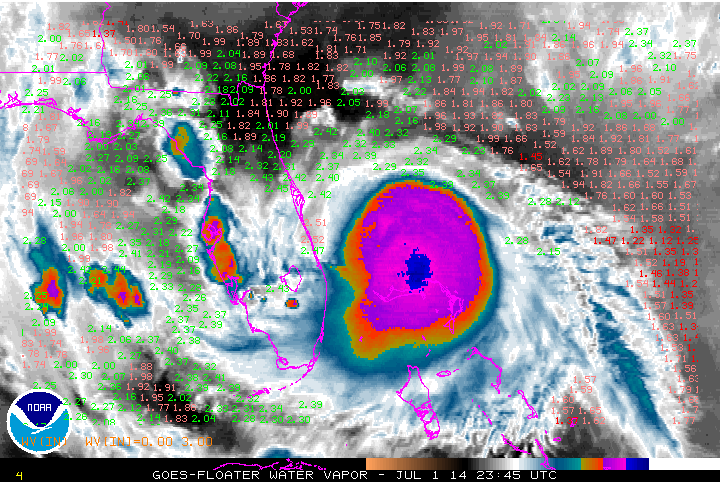
In yesterday’s post, I discussed how there was dry air in close proximity to the surface circulation associated with Arthur. This is less of an issue tonight. Water vapor imagery shows that mid-upper level dry air that yesterday was impinging on the surface circulation of Arthur has been mixed out. Precipitable water values are now safely over 2” well outside of Arthur’s central dense overcast. This shows that the persistent convection associated with Arthur for the last 24 hours or so has mixed out the dry air near the center of circulation, as the updrafts containing warm, moist air literally transport moisture from the ocean into the upper atmosphere. If shear stays low, dry air won’t be a significant issue for Arthur going forward.

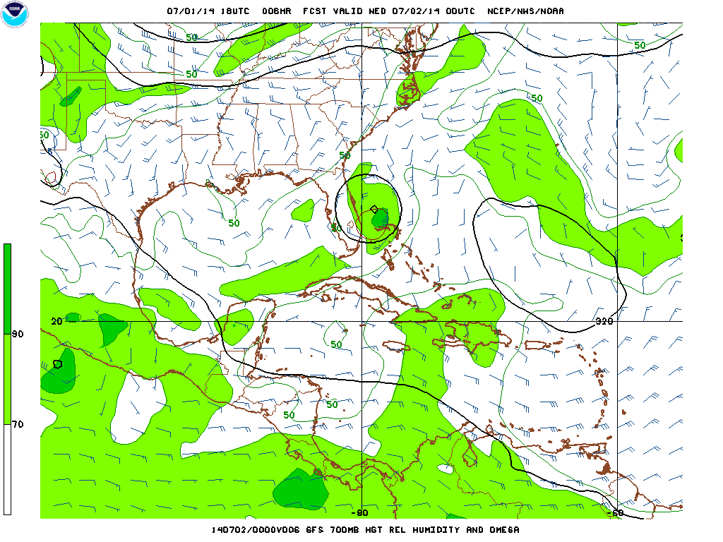
Looking at the 18z GFS run valid Wednesday evening, the model shows good upper level outflow persisting. Note how the wind barbs essentially rotate around Arthur (the yellow blob off of the Florida coast), and don’t pierce threw it. This suggests Arthur will be in a good upper level environment for intensification for at least another 24 hours.

Moving ahead to Thursday evening, increased upper level winds associated with a longwave trough settling into the eastern US will begin impinging on Arthur. However, if Arthur can become a deep cyclone over the next 48 hours (as I expect and as the GFS depicts), then it would likely take until Friday for shear to impact the core of the cyclone. You have to squint a bit to see it, but note how the few wind barbs located over the core of the cyclone as light and divergent, indicating that shear would not be affecting the cyclone yet by Thursday evening. By Friday, the shear will likely become too much for the outflow of Arthur to fend off, resulting in the beginning of a weakening by late Friday and a transition to an extra-tropical cyclone by the weekend.

The tropical cyclone heat potential product, essentially a product of the depth of warm water in the ocean, shows that there is a little juice off of the southeastern coast, but not a ton. This, combined with Arthur’s expected slow movement over the next couple of days, may impact the ceiling of Arthur’s top intensity.
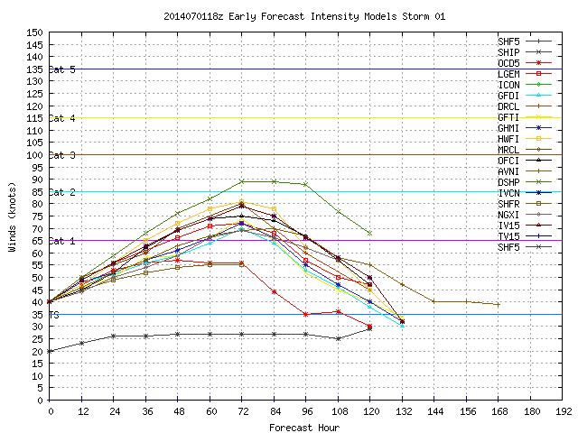
Most intensity models bring Arthur up to category 1 intensity by Friday before weakening, with the SHIPS model bringing it up to category 2 intensity. Given radar/satellite trends mentioned above, the expected favorable environment through early Friday, and marginally deep warm waters off of the southeastern coast, I’m inclined to lean towards the higher end of this intensity guidance. This means Arthur could become a category 2 hurricane for a time Thursday night or Friday before weakening. If current organizational trends continue, Arthur could become a hurricane by Wednesday evening.
Where Will This Go?
A look at the 6 hour GFS forecast valid 8PM EDT Tuesday for the steering flow relevant to Arthur right now shows that Arthur is still in a weak steering flow. This explains Arthur’s continued nearly stationary motion. However, a trough visible over the upper-Mississippi and Ohio Valleys in this image will combine with the intensifying ridge of high pressure to the east of Arthur to cause Arthur to begin moving north and eventually northeast of the next couple of days.

A look at the steering flow that would be relevant to Arthur if it becomes a hurricane as expected by Thursday afternoon shows that it will be influenced by strengthening southerly and westerly winds. This suggests the cyclone will really begin to move northeast by Thursday and especially Friday and into the weekend.
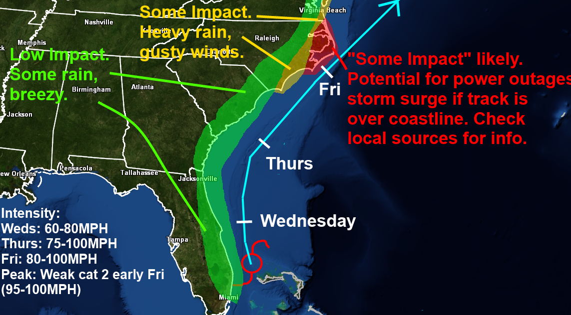
Although it has become very likely that as expected, Arthur won’t quite make landfall in Florida, some rain will continue to affect the state over the next day or so. Breezy conditions and an enhanced rip current risk will continue along the eastern coast through Wednesday. By the time we hit Thursday and Friday, questions over whether or not Arthur will significantly impact the eastern Carolinas or not remain.

The most recent update of the hurricane models remain tightly clustered in showing a track over or extremely close to the Outer Banks, with a track close enough to bring at least mild impacts to coastal South Carolina and eastern North Carolina. A track like this would likely have minimal impacts along the East Coast north of southeastern Virginia, save for perhaps some wind/rain for Long Island and Cape Cod Friday night into Saturday morning.
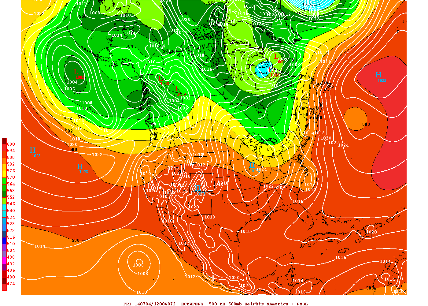
A look at the pattern shown on the European ensembles for Thursday morning shows the aforementioned trough approaching the eastern US and getting ready to begin accelerating Arthur to the northeast and eventually out to sea. However, there are modestly above average heights across the northwestern Atlantic, which allows the trough to slow down and take on a modest negative tilt over the Great Lakes and Ohio Valley. If this occurred, it may still allow the western portion of the guidance envelope shown above to play out.
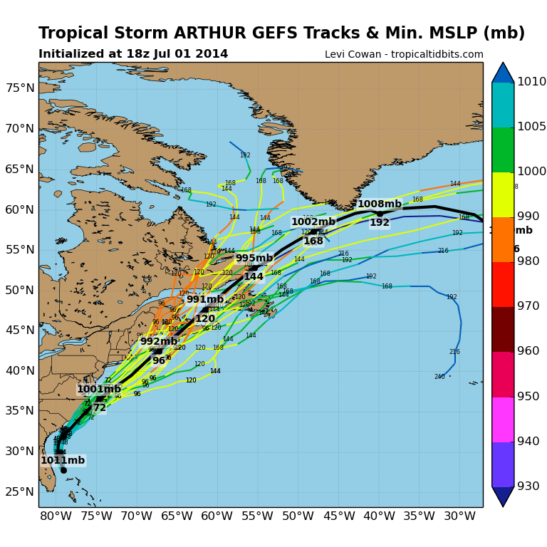
The GFS ensembles (tracks shown above) agree with the European ensembles on the pattern that will steer Arthur over the next several days, and have several members that take Arthur inland over North Carolina. Some of the members are likely way too far west (a New England impact is extremely unlikely at this point), but the ensembles in general are farther west than the hurricane models with the track of Arthur.
The European ensemble mean suggests that most members may also be a bit farther west than the hurricane models. The mean position of Arthur Friday morning is south of eastern North Carolina and moving northeast, which would take it extremely near or over the Outer Banks.

The National Hurricane Forecast is as always extremely close to the average of the hurricane models shown above, and shows a hurricane tracking extremely close to the Outer Banks Thursday night into Friday.
The point here is that minimal impacts…rain and some breezes…are likely for coastal Florida, Georgia, and most of coastal South Carolina. More significant impacts are possible for eastern coastal South Carolina, eastern North Carolina, and extreme southwestern Virginia. Strong winds, heavy rains, and some storm surge will be hard to avoid in the Outer Banks, but the significance of impacts here will depend on whether Arthur can track over or west of the Outer Banks, or stays just to the east. If Arthur misses the Outer Banks, impacts would not be significant in the grand scheme of things. If Arthur passes over the Outer Banks or even into eastern North Carolina, there would be notable impacts to the region. It is a very close call right now as to where this tracks in relation to North Carolina.
Heavy rains are possible ahead of a cold front over a good portion of the Mid-Atlantic and New England Thursday into Friday. These rains will not be directly related to Arthur, however moisture being drawn north from Arthur may cause these rains to be heavier than normal.
This storm will unfortunately impact parts of the southeastern US at a time when a lot of people may be traveling. Conditions will improve in Florida by Thursday morning, in extreme eastern Georgia by Thursday night, and in the Carolinas/eastern Virginia by Friday evening, however if a direct hit occurs, then power outages/damage may still affect the holiday weekend, mainly in eastern North Carolina and the Outer Banks. It is not up to me whether or not you alter plans to that region this weekend, however it is very important to heed any evacuations ordered by local government.
Here is an updated quick look at my thoughts: