

A large number of the model images used in this post can be found at tropicaltidbits.com
It’s been a fairly busy week along the East Coast of the US, with one low pressure system on Sunday bringing disruptive freezing rain to parts of New Jersey, eastern Pennsylvania, New York and some snow in New England, and another low pressure bringing some snow to the Mid-Atlantic and southern New England Wednesday into Wednesday night.
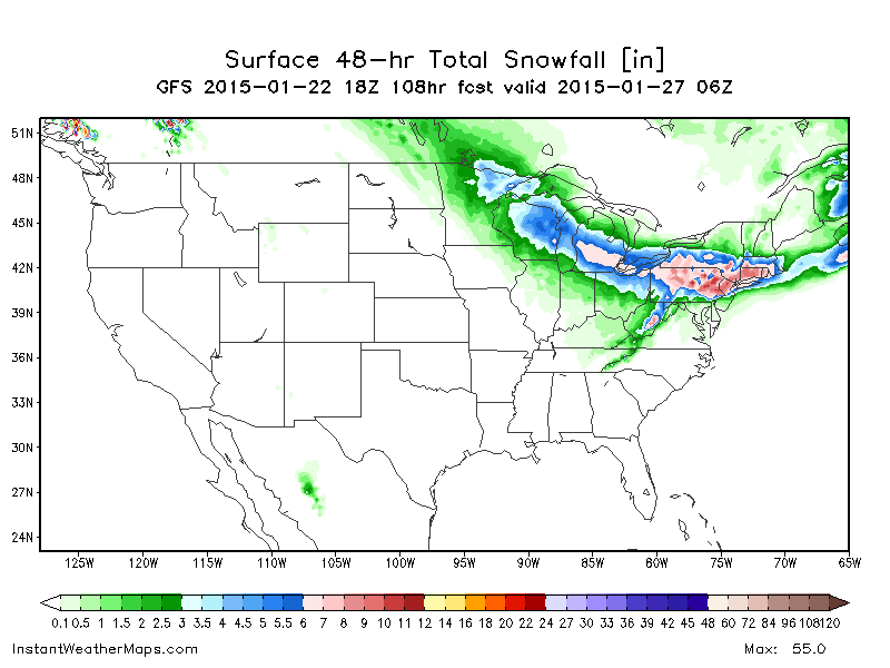
There will be two more East Coast low pressures between now and Monday, with both bringing at least some snow. The system that will turn into a Nor’Easter for Friday night and Saturday is already hitting Texas with locally heavy snow, and parts of the Gulf Coast with heavy rain this evening:

The main topic of interest over the next couple of days is what will happen to all of this moisture when it hits the East Coast and develops a fairly strong low pressure Friday night and Saturday, producing some snow in the Mid-Atlantic and Northeast.
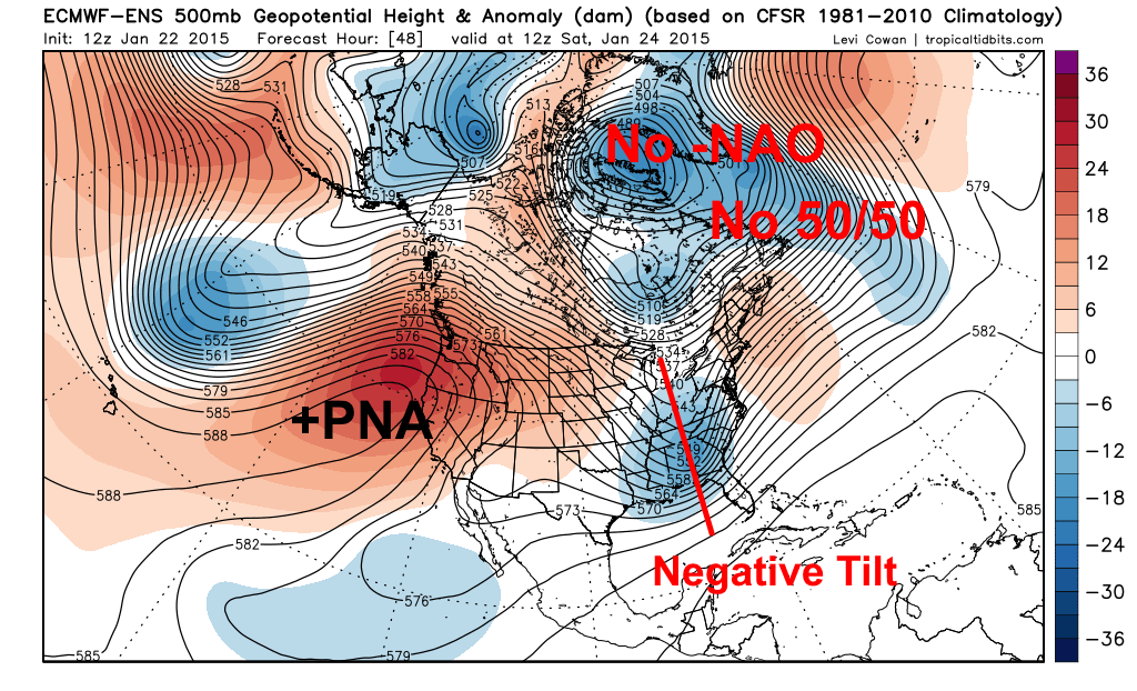
There is good model agreement in the trough associated with this storm taking on a negative tilt Friday night into Saturday morning as it passes over the Appalachians. This IS where East Coast snow fanatics want to see the trough take on a negative tilt…however, there are some issues that will limit the potential snowfall amounts with this storm, mainly involving the Atlantic side of the large scale pattern…with no real blocking over Greenland and the NW Atlantic (the attempt at a weak east-based –NAO isn’t very helpful here), the airmass will be marginally cold for snow, especially closer to the coast, and the trough with the storm will be more progressive than is preferable, meaning precipitation will pull east just as the storm tries pulling cold air in.
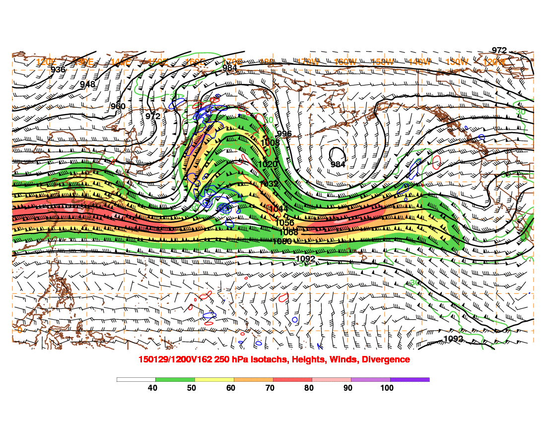
Regardless, there is good model agreement on high PWAT (perceptible water) air wrapping into the low pressure system off the East Coast on Saturday with great upper level divergence from a 160 knot upper level jet streak, so a rapidly deepening low pressure system off the East Coast on Saturday seems like a good bet:
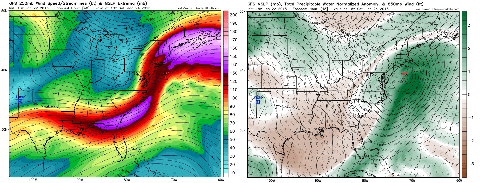
Again though, the issue isn’t necessarily the strength of the system, it’s the lack of blocking causing a lack of cold air and a more progressive storm, both of which hurt snow chances for the East Coast. Looking at the GFS, you can note that the central pressure is modeled to drop 20mb in 12 hours during the day Saturday…which is definitely a strong deepening…however, also note how the low is moving NE at warp speed, with cold sector precip only beginning to really expand just as the storm is pulling off to the east:
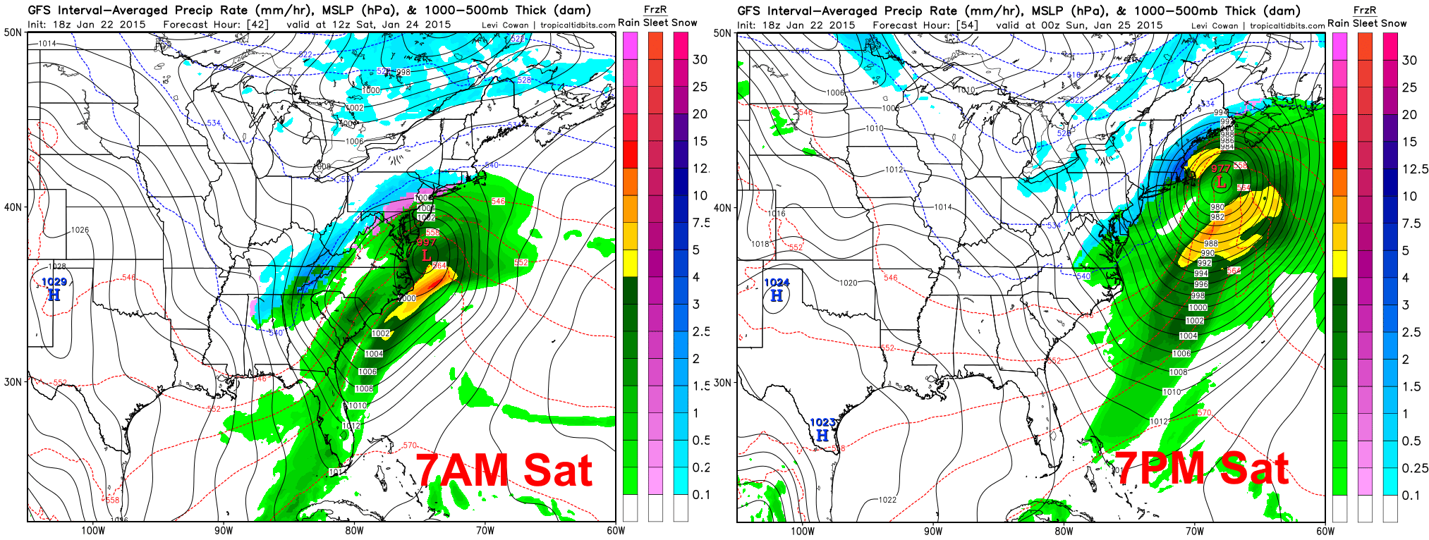
Given all of these mitigating factors for heavy snow, I can’t envision more than a stripe of 3-6” of snow in the inland Mid Atlantic, from the WV/VA mountains up just northwest of the DC-Baltimore-Philly Corridor, and probably just north of NYC too…those cities will probably see precipitation end as snow, but amounts will be mainly light…NYC and Philly could end up getting 2-4” if all goes “well.” The higher elevations in eastern PA or northern MD could see locally over 6″. By the time the storm passes New England, cold sector precipitation will be expanding as the low really wraps up, so heavier snow amounts…possibly on the order of 4-8” or so…could occur. The corridor of heavy snow in New England will still be narrow, with areas near the coast in southern New England likely struggling to see snow, with precipitation only making it so far inland. The sweet spot may be just inland from the coast in southern New England, and then southern Maine.
Clipper and Miller B Redevelopment Sunday-Monday:
After a little Miller A action on Saturday, we’ll get to see a northern stream dominant system affect the Great Lakes, Appalachians and parts of the East Coast with snow Sunday and Monday. This will be an unusually potent clipper, with a very strong shortwave associated with it, and could produce locally 6”+ of snow across parts of lower Michigan, northern Ohio, southwest New York and western/central Pennsylvania before transferring to the East Coast:

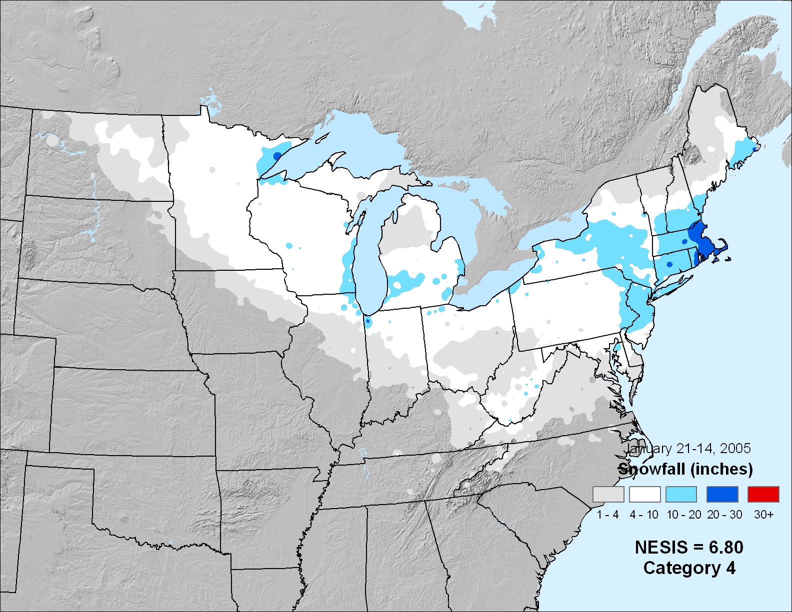
It is not common to see such a sharp shortwave with clippers. In fact, the intensity of the shortwave, the positioning of ridging over the western US, and the positioning of the polar vortex east of Hudson Bay bears some similarities to the “Super Clipper” event in January of 2005:
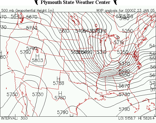
The “Super Clipper” went on to spawn a potent Miller B low off of the East Coast and became a very memorable snow storm over a large area…with Philly and NYC both receiving over a foot of snow, and Boston receiving close to two feet…and not to mention, a huge area of 6-12”+ snow over the Great Lakes:
However, although there are some similarities, there are enough differences that make a repeat performance EXTREMELY UNLIKELY! Let me make that clear…the above comparison was simply to help illustrate my point that this clipper will be potent. Let’s take a look at the larger picture surrounding the clipper/Miller B redevelopment Sunday and Monday to get a grasp of what we can realistically expect to happen:
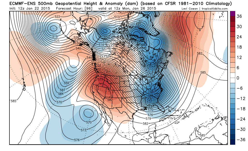
The continued theme…on the European ensemble mean 500mb pattern valid Monday morning…is a continued lack of blocking over the Atlantic. Because of this, the shortwave associated with the clipper has trouble taking on a negative tilt before hitting the East Coast (which is a little too late), and moves out to sea fairly quickly. There will be plenty cold air along and north of the clipper track for snow this go-around, but the amount of snow that falls is in question.
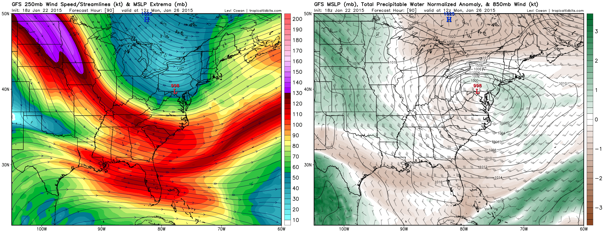
When taking a look at factors that may determine how quickly this low strengthens as it hits the East Coast, things are not nearly as favorable as they will be on Saturday. Although there is some upper-level jet support (left) from the left-exit quadrant of a jet stream rounding the base of the trough, and a little bit from the right-entrance quadrant of a jet streak to the northeast of the storm, the jet is not nearly as strong as what is expected on Saturday along the East Coast. In addition, note how PWAT values are much lower on Monday morning as the low pressure begins transferring to the coast, which suggests a more stable atmosphere. This, along with the trough only beginning to take on a negative tilt as it reaches the East Coast, suggests that a rapidly deepening low pressure system seems unlikely. Even with all of this “bad talk”, this is still a very potent clipper coming down, so there will be some mechanisms in place Sunday night into early Monday across parts of the Mid Atlantic and possibly southern New England to get heavy snow to occur:
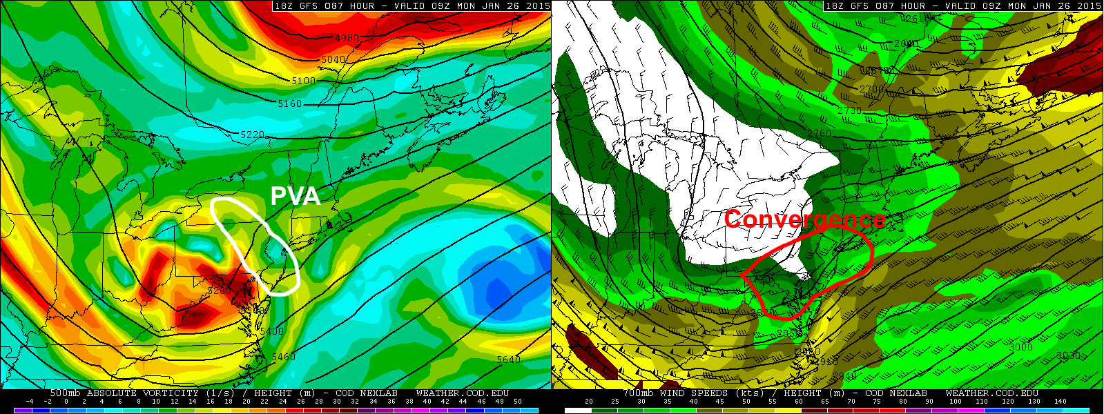
A lobe of very strong vorticity, or horizontal spin in the atmosphere, will advect into parts of the Mid-Atlantic (and later far southern New England) Sunday night into Monday morning. This is a source of lift. In addition, strong mid-level winds (right) will be wrapping around the southern side of this clipper. Areas near the nose of these stronger winds often see moderate to heavy snowfall.
So essentially, the dynamics of the system still argue for a swath of heavy snow, while the overall pattern argues against it. What this likely means is that moderate to heavy snow will occur across parts of PA, NJ and southern NY, but the snow will only last a few or several hours, thus keeping amounts more moderate. This evening’s GFS run shows a large swath of over 6” of snow from this clipper:
The European model, although I can’t show it, shows a swath of much lighter snow a little farther south than the GFS, along the lines of 3-6” across parts of the Great Lakes and 2-4” or so across the Mid Atlantic.
Given how dynamic the clipper will be, I’m favoring a potentially moderate snow storm across parts of the Mid-Atlantic with this clipper/Miller B redevelopment Sunday night into Monday morning. Clippers/NW flow disturbances are one thing that the GFS has consistently beaten the Euro on in the past. If there was more blocking over the Atlantic and the storm wasn’t zipping out to sea before getting a chance to really deepen on Monday, I’d favor a more significant storm, but as it is, I could see a swath of 3-6” or maybe 4-8” of snow occurring across some of the areas outlined above. Given the progressive nature of the pattern and the storm not really having a chance to bomb out until well east of the coast, I don’t favor it hooking far enough north to bring much snow to southern New England.
Long Range Pattern:

After all of this storminess over the eastern US this week and into the beginning of next week, the teleconnections strongly argue for a brief relaxation in the troughing over the eastern US. A +NAO corresponds to low pressure over Greenland, which leaves room for a ridge over the eastern US, while a +AO corresponds to low pressure over the North Pole, which typically keeps colder air locked up to our north. A negative PNA corresponds to a trough on the West Coast, which also corresponds to ridging east of the Rockies. As terrible as this pattern sounds for snow in the eastern US, the relaxation in the cold looks brief…although, the Euro ensembles agree close enough with the above teleconnections and suggest a brief warming across much of the central and eastern US for late next week:

Again though, this relaxation in the cold will be brief (and with the proximity of the polar vortex to the Great Lakes and northeast, some of those areas may still hang on to somewhat below average temperatures through next week), as you can already see signs of renewed cold on the above map. Note how ridging extends almost all the way to the North Pole over the north-central Pacific, which causes a “cross polar” flow to develop into Canada. This will load Canada up with cold, and that cold looks to come back into the US right around the turn of the month.

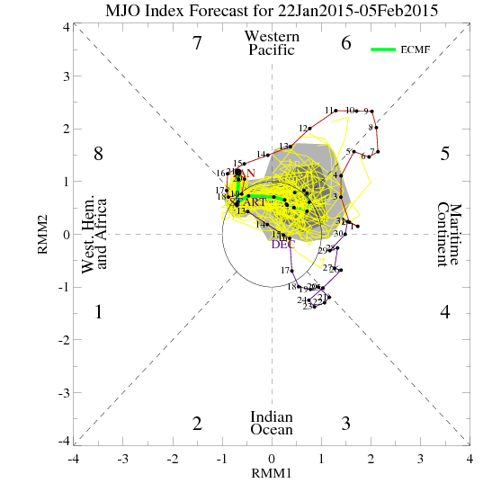
Tropical forcing is still most prevalent in the western hemisphere, although it is beginning to weaken. The tropical forcing in the Pacific recently helps explain the eastern US trough and storminess. The good news is that a strong MJO pulse doesn’t appear to be developing over the Indian Ocean. For the first time in a while, the SOI (Southern Oscillation Index) is strongly negative, indicating much weaker east-west trade winds than normal across the equatorial Pacific. The atmosphere has responded with a recent burst of westerly low-level winds along and east of the Dateline, which has caused a recent warming of waters in that area:

This is the strongest burst of westerly winds in the El Nino regions since October. This modest kick by the weak El Nino may help promote a more favorable MJO re-developing in early to mid-February. In the interim, a continued strongly –WPO, re-emergence of the –EPO and likely development of a +PNA will likely allow cold into the northeastern and perhaps north-central US around the beginning of February.
The Pacific jet is shown by the GFS to retract a bit again late next week, which so far this winter, has been good at developing ridging over the western portion of North America. In addition, a trough persists over eastern Asia. This suggests continued ridging over the high-latitudes in the north-central Pacific (-WPO). With the MJO likely remaining fairly weak for the next week to 10 days, I don’t see much to mess up the extensive ridging expected to develop in the WPO and EPO, and probably PNA regions by the end of next week. This has been expected for quite some time and remains fairly consistent on our models. For reference, the Euro’s MJO forecast for the next two weeks…mainly in the circle of death, and then possibly coming out weakly into phase 6 in early February:
This isn’t really enough to disrupt the favorable Pacific pattern that should be in place for the foreseeable future. Both the GEFS and Euro ensembles agree on this favorable Pacific pattern in the mid-long range, with the ridging setting up next week and a trough really digging into the eastern US for the first week of February…the GEFS 6-10 and 11-15 day 500mb mean height forecasts are shown below:
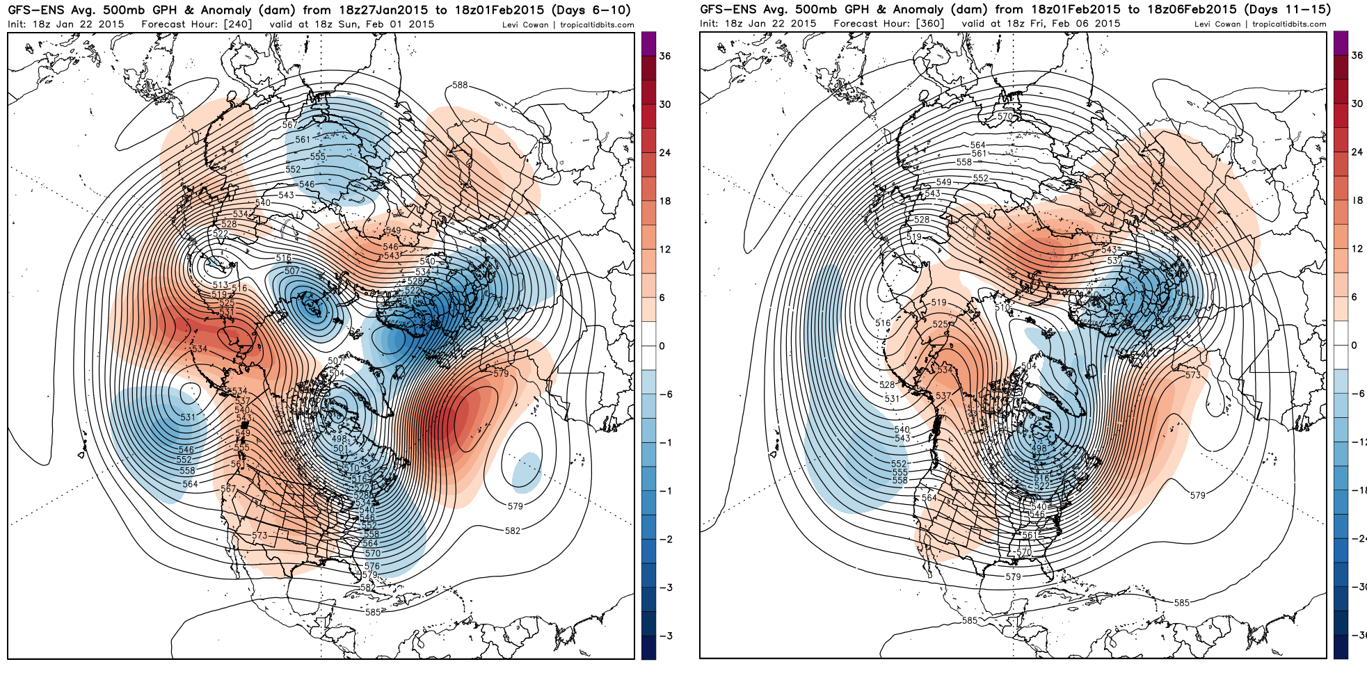
With a long duration cross-polar flow, boughts of severe cold would be possible, particularly in the Upper Midwest, Great Lakes, and Northeast. Also note the hits of an active sub-tropical jet off the West Coast, and hints at a split flow over the western US (sub-tropical jet energy sneaking under the ridge). A split-flow could be conducive to winter storms across parts of the southern and eastern US (probably not all the way to the Gulf Coast, but snow or ice into northern portions of the Gulf Coast states could be possible if the timing is right with a piece of energy and cold air).
There are some hints at a piece of sub-tropical jet energy ejecting east across the southern and eastern US in the first few days of February just as the cold air is really crashing into the eastern US. IF this can eject BEFORE the cold air really comes crashing in, it could make for a decent storm in some of these areas. However, if it is slow to eject, then the cold would likely suppress it way to the south.
There are hints at a brief relaxation about a week into February which could open the door back up for more storms.
So, here is my breakdown of the next few weeks:
Week of January 25-February 2:
Snow and brief cold shot to start the week in the eastern US with a clipper and Miller B redevelopment off the East Coast. Mild in the west and central US, with that mild air trying to spread east later in the week. Cold air will probably come down into the Upper Midwest/Great Lakes towards the end of this week, and a snow/ice event could be possible across the southern Plains, Mid Mississippi Valley, Tennessee/Ohio Valleys and parts of the Mid Atlantic/New England IF a moisture laden piece of sub-tropical jet energy can eject east out of the southwest US quickly enough. Models are in disagreement over this and it’s tough to call one way or another. The *still* positive NAO in this timeframe would make it hard to get a KU type snow storm, however a moderate event would be possible.
Week of February 2-8:
There could be a storm ongoing at the start of this week in the eastern US. I believe the pattern will become very cold in the eastern 1/3 of the country in this timeframe due to extensive ridging over western North America and a cross-polar flow. This would keep any storms suppressed. If the sub-tropical jet remains active as appears possible, there could be some wintry precip in the Deep South. Predictability is very low this far out though so confidence in any wintry precip there is low at this time.
Rest of February:
The ensembles appear to be gearing up for a bit of a relaxation in this cold during the second week of the month. This could allow storms to occur farther north again if the sub-tropical jet remains active. If the MJO orbits back towards more favorable phases in this timeframe, as the long-range models appear to be hinting at, the sub-tropical jet could again become more active.
The big question mark is the state of the AO and NAO. I feel confident that the Pacific ridging will generally persist due to a very strong +PDO, potentially favorable tropical forcing, and persistent troughing over eastern Asia. The long range models are trying to displace the stratospheric polar vortex some in early February, and this persistent Pacific ridging in the troposhpere could try to upwell into the stratosphere and continue to perturb the stratospheric polar vortex. If this occurs, a more –AO and subsequently better NAO state would be possible by mid-February. This will likely determine if the eastern US can pull off a major snow storm or not during mid-late February…but I think the Pacific pattern will allow for it if the Atlantic can cooperate.
Will try to have another long range update early next week, time permitting.
