
UPDATED SNOWFALL ESTIMATES:
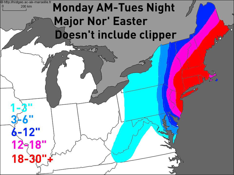
I have updated our snowfall estimates for the impending Nor’ Easter/blizzard for the East Coast. Forecast totals include:
DC: 1-3″
Baltimore: 3-6″
Philadelphia: 12-18″
NYC: 18-30″+ (blizzard)
Boston: 18-30″+ (blizzard)
Coastal flooding is also a concern from New Jersey northward into New England due to strong on-shore winds. Damaging wind gusts are likely on Cape Cod, Nantucket and Martha’s Vineyard.
As discussed this afternoon, the European model supports more snow farther west, while the GFS and NAM are much lighter farther southwest (for example, both only show light to moderate amounts for Philadelphia, and even the new NAM is less than a foot for NYC). After doing a careful review, the clipper that will spawn our Nor’ Easter is behaving very close to how the Euro expected as it moves across the Ohio/Tennessee Valleys this evening. This afternoon’s NAM/GFS models were already a little to far northeast with the clipper. This suggests the Euro’s heavier snows farther southwest are certainly possible. In addition, the GFS and NAM appear to be suffering from “convective feedback”…that means that they allow thunderstorms to incorrectly influence the low pressure’s track and intensity Monday night into Tuesday morning. The thunderstorms are shown to be northeast of the developing Nor’ Easter, meaning the thunderstorms on the NAM/GFS may be artificially pulling the low to the northeast. The upper level evolution on the NAM/GFS of the storm, while a little quicker with everything than the Euro, don’t appear to match-up with how quickly they move the low northeast Monday night.
I still trimmed amounts a little bit over parts of SE Pennsylvania, extreme eastern Virginia and the Delmarva. This is because “Miller B” low pressure systems (clippers that re-develop as Nor’ Easters) tend to “screw” the Mid Atlantic. They often feature a very sharp southwestern cut off to the snow, with Philadelphia often in the cross hairs of this sharp cut-off of the heavy snow. Although the Euro’s forecast appears to be reasonably on track, the areas discussed above often see less snow than modeled in these Miller B situations. I believe the Euro’s snow forecast is close to reality but did take a little bit off of the southwestern edge.
