
This won’t be my longest post because I need sleep. BUT, as I posted last Friday morning, I was intrigued in the potential for a winter storm around the turn of the month. Due to the East Coast blizzard stealing the focus for a few days, I haven’t updated on that threat since. But it’s still there.
A current look at the 500mb (middle of the atmosphere) weather pattern shows a shortwave ridge moving east across the central US bringing a brief moderation in temperatures to that region. This map currently isn’t a good one for a major snow across the central or eastern US, but features that will make the pattern more conducive for snow are already on the map (I love it when things are already on the map!)
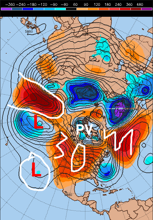
-A polar vortex remains anchored over northeastern Canada. This polar vortex will be pushed south towards Hudson Bay this weekend due to the AO turning negative. This will help ensure that cold air is in place across the north-central and northeastern US this weekend, and limit how far north any storms can go.
-A fairly potent clipper type system circled over the central US will help re-enforce the trough off the East Coast. This will spawn a fairly strong storm over the Canadian Maritimes Friday into Saturday, which will help the NW Atlantic thumb ridge extend north towards Greenland and become a –NAO block this weekend.
-A vort-max will break away from a large upper level low pressure sitting south of Alaska by Friday and become a shortwave that will move into British Columbia and dive towards the Rockies.
-Moisture with a sub-tropical jet cut-off low off of Baja of California will attempt to move east this weekend ahead of the shortwave diving into the Rockies, and potentially get tangled up with it and help cause a storm.
-Ridging will build up the west coast of the US and British Columbia from the south through this week and will also really build into Alaska from the west. This ridging, combined with the polar vortex shifting south by this weekend suggest the shortwave diving into the Rockies that may eventually spawn our storm could dig more aggressively than some of our current models.
You can see how the strength/track of the northern shortwave diving down influences if any of the cut-off low over the SW US ejects east or not by looking at our two most recent runs of the GFS model:

Tonight’s 0z GFS run on the left was a little bit more pronounced with the shortwave diving into MT/WY Saturday evening. This allows more vorticity (color fill) and moisture (not on these maps) with the cut-off low to eject farther northeast. Wednesday evening’s 18z GFS run on the right was flatter with the shortwave diving into the upper Plains, and note how the cut-off low remains larger and less vorticity advects out into the Plains. Here’s the difference that made in snowfall output:
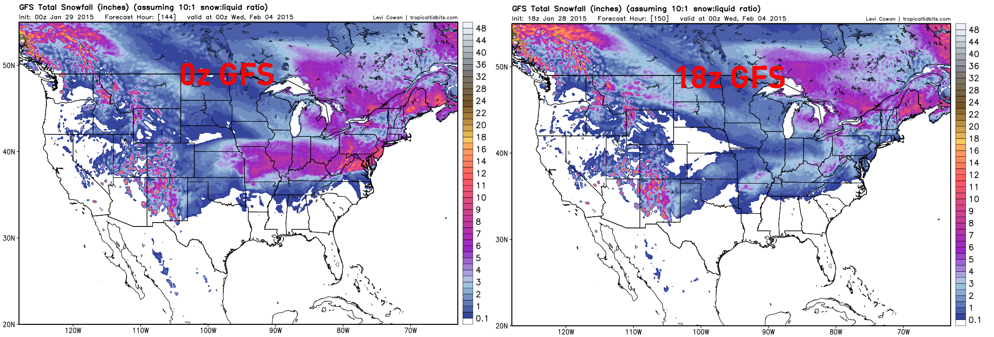
The 0z GFS has a much larger swath of moderate to in some cases heavy snow from Kansas clear east to the Mid Atlantic, with a low tracking across the Tennessee Valley. The 18z GFS has a swath of very light snow from the Ozarks east through the lower Ohio Valley and Mid Atlantic with no real surface low. Note that the snow over New England is from the storm this Friday in that region that I’m not really discussing in this post.
So obviously, a small change in the shortwave diving into the Rockies on Saturday and in how much of the SW US cut-off ejects east made a huge snowfall difference.
For reference, this evening’s Canadian model run ejected a little bit more of the cut-off and had a swath of even heavier snow a little farther north, with a surface low track along the Ohio River to near Pittsburgh, before re-developing off of the coast near DC:

This evening’s Euro run ejected a little less of the energy and was noticeably weaker with the shortwave diving into the Rockies on Saturday and had a swath of 2-5” type snows from Missouri points east across southern IL/IN/OH, northern KY and into the lower Mid-Atlantic.
What do the ensembles say?
Everytime our main forecast models are run, the model is re-run 20-50 times (depending on the model) with different perturbations to come up with a reasonable range of forecast outcomes.
When looking at a plot of the 1008mb sea-level pressure line of each GFS ensemble member, we see that about half of the ensemble members (maybe one or two less) have a low pressure deeper than 1008mb Sunday evening. Most of them track it on either side of the Ohio River (none north of approximately I-80 in Ohio):

This is a couple members showing a stronger low pressure and farther north track than this evening’s 18z run of the GFS ensembles:

A slight trend for a stronger storm has occurred in the GFS ensembles this evening.
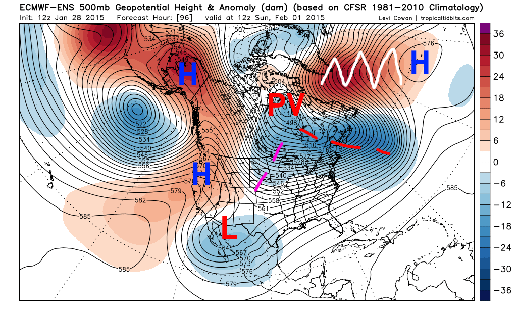
The Wednesday afternoon Euro ensemble mean has a low pressure system much farther southeast by Monday morning:

It should be noted that the 0z Euro did bump north some from its 12z run…it’s possible its ensembles bump north too, but they aren’t out yet.
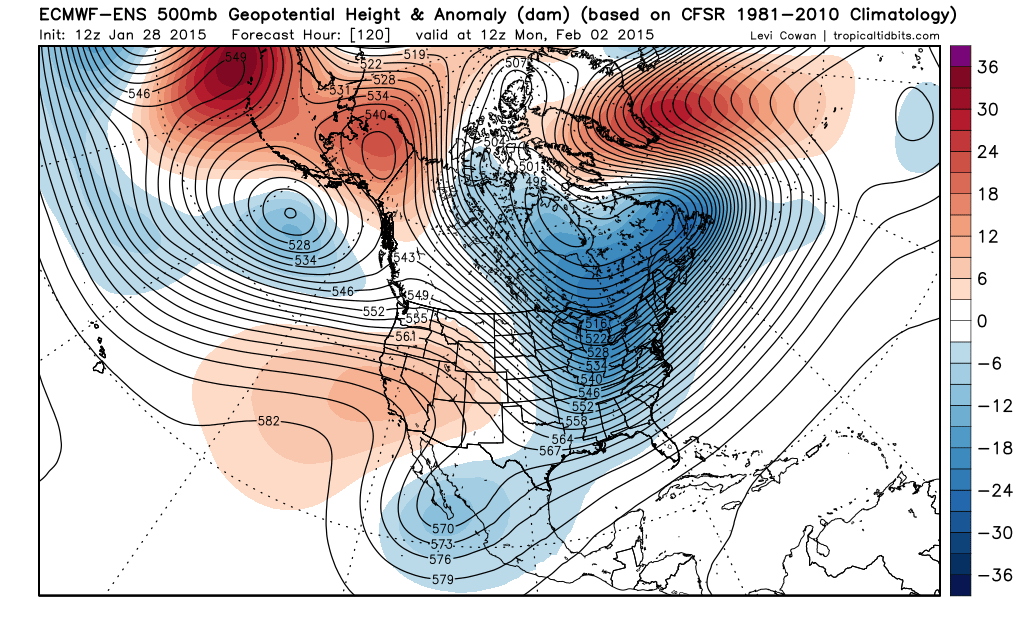
The GFS ensembles this evening indicate a general trend to a stronger storm being possible. The pattern supports this in my opinion:
The reason I believe a stronger storm is possible is mainly due to the large upper level ridge of high pressure on the west coast combining with the polar vortex over Hudson Bay causing a high-amplitude north-northwest flow over Canada into the Rockies. This could conceivably force the shortwave diving into the Rockies on Saturday (denoted by the purple lines) to dive in more aggressively and farther southwest, which would allow it to help kick-out the cutoff low over the SW US/towards Baja, and help contribute to a bigger storm.
What the storm does when it gets to the east coast is highly dependent on how strong it gets over the Great Lakes/Ohio Valley. A stronger storm farther west would likely track north of the Ohio River, and would probably be bad news for snow south of the Mason-Dixon line east of the Appalachians. A weaker storm may work for areas farther south but would have less snow overall.
If the storm doesn’t cut too far north while west of the Appalachians, the pattern is favorable for decent snows in New England and the Mid Atlantic (12z Wednesday Euro ensembles shown above for Monday morning). This is due to a –NAO (reds extending towards Greenland) and low height anomalies over Newfoundland acting as a 50/50 low…features that were missing when the blizzard ended up whiffing the Mid Atlantic Monday and Tuesday of this week.
Overall, due to the high amplitude ridging over the western portions of North America and polar vortex over Hudson Bay, I’m leaning towards the northern branch shortwave that possibly helps kick out a part of the SW US cutoff low and cause a storm being a bit stronger than currently modeled. This argues for a stronger storm. However, due to the –NAO, PV location and pseudo 50/50 low I’m not favoring a storm that cuts hard into the Great Lakes. Instead, a storm that runs along either side of the Ohio River before reforming off of the Mid Atlantic Coast is my favored solution at this time…with a swath of moderate to heavy snow north of that swath from the central Plains points east.
There are some caveats here…the main one being that the shortwave that will dive into the Rockies and cause all this is still a part of a large upper low in the Northern Pacific ocean, and won’t move over the North American radiosonde network until Friday night or early Saturday. This suggests wild model swings are possible for another couple of days, and also means that it is hard to be confident in one solution…although I am certainly leaning towards one at this time.
WHAT COULD GO WRONG (in order from most to least likely):
- Shortwave diving into Rockies is flatter, cutoff doesn’t eject. Just a swath of light snow farther south instead of a bigger storm.
- Shortwave diving into the Rockies is much stronger than expected, entire cut-off ejects, larger and stronger storm would cut into the Great Lakes with a potential transfer to the New England coast. May mean heavier snow amounts but they’d be farther north…from say St. Louis to Chicago to Detroit to Toronto and perhaps a bit farther northwest.
- NAO and 50/50 combo don’t work out…storm would be more prone to cut either into the Great Lakes (even if weaker in this case) or at least run inland from the East Coast.
- The models find a new way to f*** everything up. We’ve seen a lot of that this winter.
So, lots of stuff to watch. Will call forecast confidence low due to the large model spread and inherently unpredictable nature of SW US cut-offs and shortwaves that are still a part of a N. Pacific gyre. Will try to update Friday but no guarantees…busy week for me.
