
After a very brief hiatus late last week and into the weekend, winter is returning to Northeastern Ohio this week. Potential below 0 temperatures and lake effect snow will be the highlights over the next several days.

The current pattern across North America as of Monday evening isn’t a particularly cold one…with a slightly positive PNA and positive AO/NAO…although there is a trough over the SE US getting ready to spark yet another storm off the East Coast. However, the pieces are lining up over the Pacific for a rude arctic intrusion into the central and eastern US later this week and into this weekend.
A strong Aleutian low has developed, which is beginning to help facilitate the development of a ridge along the West Coast all the way up into Alaska (a +PNA and eventually -EPO). At the same time, a very large ridge has developed over eastern Asia (-WPO), and is forcing arctic air to filter into northern Canada. When the +PNA/-EPO become better developed later this week, very cold air will be tapped and will be sent southeastward towards the central and eastern US.
By Thursday, the first of many arctic shots of air will be plunging into the Great Lakes/Ohio Valley/Northeast. This is in response to the +PNA strengthening along the West Coast. Although ridging over western North America doesn’t extend extremely far north at this point, enough cold air is currently present over northern Canada to get some well below average temperatures into parts of the Great Lakes and northeastern US. This first arctic shot will bring our first chance for plowable snow to northern Ohio in what could be a stretch of several chances, and I’ll discuss that more shortly.

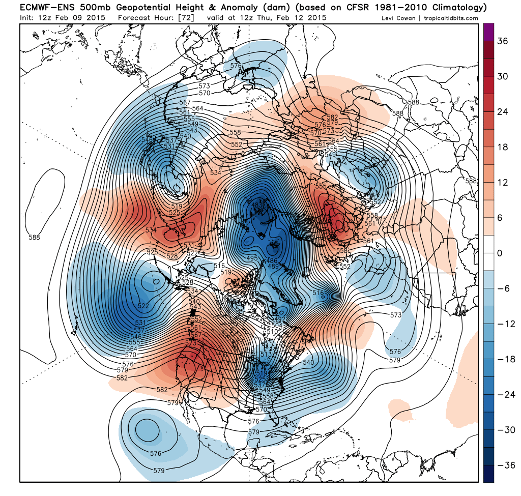
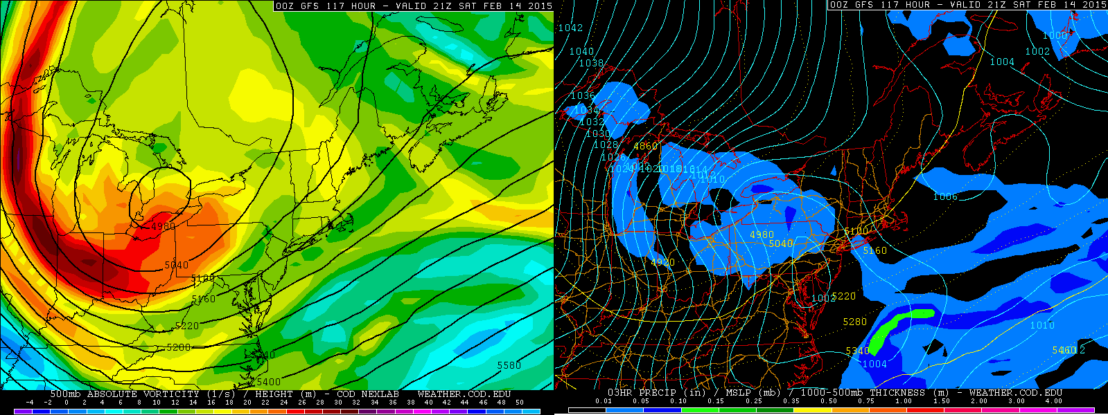
By Saturday, the ensembles (ECM ensembles shown above) agree on a classic pattern for delivering cold into the central and eastern US setting up. The +PNA ridge extends all the way into Alaska and can qualify as a –EPO…in addition, a strong –WPO persists. All of this ridging forces a classic cross-polar flow. Cross-polar flows typically mean very cold weather into the northern US, and the cross polar flow modelled for this weekend is one of the best I’ve ever seen over the last several years. Note how the isohypses on the map above run right across the North Pole and then straight down into the Great Lakes. That’s cold stuff, and well below 0 temperatures appear to be a good bet across portions of the Great Lakes and New England.
For perspective, New York City hasn’t recorded a sub-zero reading since early 1994. Some weather weenies have wondered if NYC will ever record a sub-zero temperature again. Although it is still far from a guarantee, the classic nature of the cross polar flow, very deep snowpack over Upstate New York and New England, and trajectory of the coldest air being centered near the longitude of New York City, it is not impossible that that 21 year streak of no below 0 readings is broken for NYC.
The GFS MEX guidance, which is corrected for climatology and typical model biases, is currently projecting a low of 3F for Monday morning at KNYC. MEX is known to be too subdued several days ahead of a highly anomalous temperature event, so the fact that MEX is already giving a temperature close to 0 for NYC is noteworthy. It should also be used as a check…despite the raw GFS showing temperatures easily below 0 for NYC Sunday night (the raw ECM shows a low of around -2F), climatology suggests that this is an extremely rare event. The GFS and Euro have shown NYC getting below 0 in their medium to long range forecasts a few times over the last couple of winters, and none of those forecasts have worked out. So, while it will be interesting to follow, it is still way too early to declare NYC’s long above 0 streak “broken”.

Now, onto the Northeastern Ohio talk.

A fairly potent upper level trough will drop through the Great Lakes Wednesday night and Thursday. A low pressure system will track to the north of Northern Ohio. This isn’t a great place for heavy synoptic snows, and I think synoptic snows with this system will generally be an inch or two at most. However, there does appear to be some potential lake effect snow upside as colder air swings in behind a cold front late Wednesday night…if only the damn lake wasn’t frozen! 😉

It has been very cloudy lately, however a brief break in the clouds on Saturday allowed us to take a peek at Lake Erie and its ice cover. Satellite showed a large crack in the ice extending from Cleveland and Lorain west to near the Lake Erie islands, and then north to the Canadian shoreline. Although there are clouds obscuring it in this shot, some large cracks were also visible farther east. While not optimal, this is enough open water to get some heat/moisture flux off of Lake Erie when a colder airmass moves in. Considering temperatures were in the 40’s for another 24 hours after this image with southwesterly winds, and considering another shot of above freezing temperatures with decent winds will occur on Wednesday, it is fair to assume that there will be some (albeit still limited) open water on Lake Erie by the time colder air moves in on Thursday, which could allow for some lake effect snow to occur.
Over the years, there have been some moderate lake effect events with an essentially frozen Lake Erie…the most recent one was on January 30th of this year, with parts of Geauga County and inland NW PA seeing over 6” of snow in 12 hours of lake effect off of a mainly frozen lake. I have noticed that a few factors can “help” lake effect occur when the lake is mainly frozen:
- Deep synoptic moisture
- Moisture from upstream lakes
- A source of convergence/lift from a pre-existing surface trough
- High inversion heights
- Well aligned winds
- Frictional convergence along shoreline when winds are nearly parallel to the shore
- Orographic lift when wind hits terrain inland from the lake at large angles
Most of the above factors are needed for or can help with lake effect off of a non-frozen Lake Erie, but they become more important once the amount of open water becomes greatly diminished.
For Thursday, we could have several of these factors working together when examining the GFS, Euro and NAM.
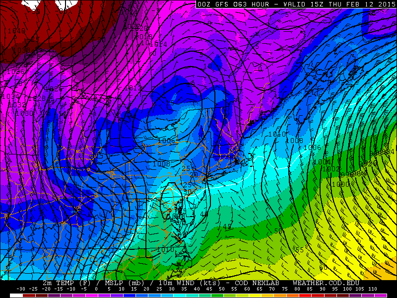
The GFS, valid 10AM Thursday, shows a sharp surface trough getting ready to cross Lake Erie from north to south. Monday evening’s NAM run had a relatively similar idea.
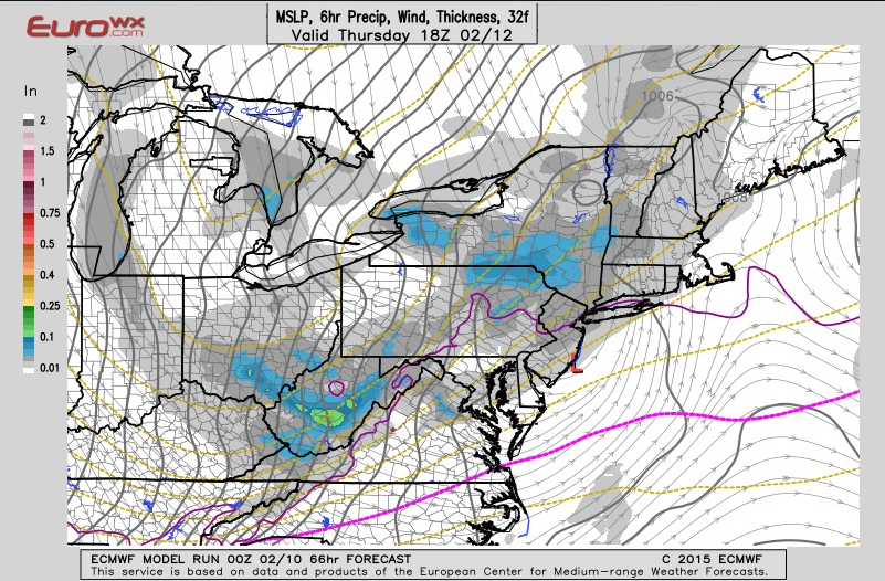
The Euro, valid at 1PM Thursday, has a similar idea with a trough dropping across Lake Erie. The difference is, the GFS/NAM maintain a more WNW wind Thursday morning ahead of the trough, while the Euro shows a more NW wind ahead of the trough. Winds should go more NW or NNW behind the trough per all models.
This feature is known as an inverted trough. It is not at all uncommon to get an inverted trough hanging back to the west of a low pressure system transferring to the East Coast. These inverted troughs have a surface wind shift, which causes low level convergence and lift, and also allows some moisture to pool along it. All of these factors can contribute to better lake effect snow than what would otherwise occur.

When taking an early look at the amount of synoptic moisture involved in the lake effect snow equation for Thursday, the GFS (pictured), NAM and Euro all show a nice lobe of moisture at 700mb rotating through with the inverted trough late Thursday morning into Thursday afternoon. Typically, deep moisture to 700mb or higher in lake effect situations can be a signal for heavy lake effect snow.

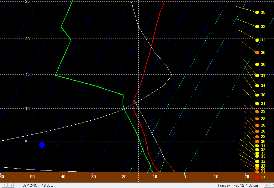
When taking a look at a couple of GFS forecast soundings for KCLE from late Thursday morning (ahead of the surface trough passage) and early Thursday afternoon (near the surface trough passage), you can see high RH air extending to near or higher than 10k feet on both soundings, with inversion heights climbing to over 10k feet around the time of the trough passage. The GFS also shows a good amount of low level omega (white line) as the trough passes. Lake effect conditions behind the trough remain decent into Thursday evening before inversion heights really begin to lower and the atmosphere dries out.
The NAM soundings are fairly similar. Although I can’t look at the Euro in BUFKIT, I’d imagine its instability and moisture parameters are similar…although the winds on the Euro go from NW ahead of the trough to NNW behind it…instead of WNW ahead of the trough to NW behind it like the GFS/NAM show. With a NW or NNW wind behind the trough, any Lake Michigan moisture would likely go west of Cleveland, while any Lake Huron moisture would stay in Ashtabula County or NW PA.
At this point, what it boils down to for Thursday’s lake effect snow potential:
Ice on Lake Erie will likely make it hard to see the instability numbers BUFKIT is spitting out (I can’t set lake water temperatures any lower than 32F in the program). However, some openings in the ice per satellite imagery, increased convergence and moisture with a trough passage late Thursday morning or early Thursday afternoon, and high inversion heights do suggest that some moderate lake effect snow may occur. The GFS/NAM scenario would likely result in the potential for somewhat higher totals than the Euro, as a W or WNW wind ahead of the trough would maximize frictional convergence along the central lakeshore and interact with any modification of the airmass over Lake Erie by any open waters by potentially focusing a band of more organized snowfall near the central lakeshore and into the primary NE OH and NW PA Snowbelt ahead of the trough passage, with weaker multi-bands that favor the higher terrain taking over in the NW flow behind the trough. Although the Euro would also suggest an increase in snow with the trough passage, it wouldn’t suggest a decent band forming ahead of the trough, potentially keep accumulations lighter. Any Lake Huron connection will be well east of Cleveland.
On the balance, with the 12km NAM/SREF members showing 0.25” of QPF or less with this lake effect event, I think amounts will only be light to locally moderate. If the GFS/NAM wind forecast pans out, there could be a nice burst for a few hours along/ahead of the trough before more disorganized multi-bands take over, which could allow for a few areas in the higher terrain east of Cleveland and in NW PA to see 4” of snow or more, with less elsewhere. The Euro would seem like a widespread 1-4” snow event with less potential for heavier amounts, except for perhaps Ashtabula County east into NW PA where some Lake Huron moisture would likely end up and enhance snowfall some.
Not the most exciting, but I enjoy the challenge of trying to pin down lake effect with a frozen lake.
More Snow Friday Night-Sunday
The arctic shot of air discussed to begin the article will move into Ohio on Saturday. Aloft, an extremely potent upper level trough (that most models have closed off at 500mb) will move over the Great Lakes…which is typically a signal for heavy lake effect snow. At the surface, a low pressure will likely drop through the Great Lakes (possibly over Lake Erie) Friday night into Saturday before this system also transfers to the East Coast and then intensifies.
Because of how potent the upper level trough diving into the Great Lakes will be, I’d have to think there will be some potential for accumulating synoptic snows, on the order of a couple inches or so, across northern Ohio as the low pressure system drops down…despite extremely low PWAT air. Then we have to try to forecast more lake effect snow with an icy Lake Erie.
I don’t want to get as specific so far out, but with a very deep trough moving overhead, high RH air should extend well above the 700mb threshold Saturday into Saturday night, with very high inversion heights. Models currently agree on winds going NNW or N at some point on Saturday, which favors good orographic lift in the secondary Snowbelt south of Cleveland and the primary Snowbelt east of Cleveland, and also favors Lake Huron moisture making it as far west as the Cleveland metro. 500mb temps are progged by the GFS and Euro to dip below -40C by Saturday evening, which if it held would be remarkably cold.
Although ice on Lake Erie will limit instability a fair amount, the high low to mid-level RH air, very high inversions, orographic lift and help from Lake Huron could combine to cause event storm totals in excess of 6” (lake effect and synoptic) from late Friday night through Sunday morning in the higher terrain of NE Ohio and NW PA. One concern is the extremely cold temperatures stunting snow growth and limiting snow:liquid ratios by Saturday afternoon, which could also keep totals from getting out of control. However, the setup appears interesting, despite the icy lake…more interesting than Thursday’s setup.
There could be some synoptic snows next week in the region as some energy in the sub-tropical jet moves out of the southwest US…I will try to discuss that more later.
