For record keeping purposes, here is a map and associated discussion I made for discussion with my Neoweather forecast colleagues regarding a potential severe event in Ohio on Tuesday May 26, 2015.
Modest large scale support for this scenario and mesoscale details to be worked out, but I think there’s enough to go on to introduce a threat for severe to the forecast for Tuesday afternoon and evening across much of the state.
Water vapor imagery shows an upper level speed max over TX with a larger trough moving NE towards the Great Lakes, with a ridge off the SE coast. Between the trough and ridge, a flow off the Gulf of Mexico is persisting with this moisture plume moving towards the Ohio Valley and Great Lakes. A look at 12z observed soundings from the TX/AR/LA/OK region where our mid-level lapse rates on Tuesday will come from reveal only a modest EML over TX/OK…and ongoing convection in that area will likely overturn this, resulting in rather weak mid-level lapse rates over the Great Lakes/Ohio Valley on Tuesday. Observed soundings from the TN Valley and Dixie region show variable quality to the low level moisture…perhaps due to convection that was ongoing this morning in that region affecting the soundings…however, I have a feeling moisture depth will be reasonable across the Ohio Valley and southern Great Lakes on Tuesday. Recent dry weather across much of the state may limit evapotranspiration, but 12z observed soundings and current observations suggest dew points in the mid 60’s on Tuesday…even with some heating and mixing…are reasonable, and this is fairly close to model projections. With weak mid-level lapse rates but quality low level moisture, weak to moderate MLCAPE on the order of 1000-1500 J/KG will likely develop assuming some sun and heating/mixing occurring during the morning/early afternoon on Tuesday across Ohio.
With a strong upper level ridge off the SE coast and no strong shortwaves to try to lower heights across the eastern US evident over the next day or so, the synoptic scale front will likely remain well west/north of the region on Tuesday, meaning that we will have to rely on smaller scale triggers to get thunderstorms to fire. The GFS and NAM are both showing some mid-level theta-e advection during the morning which could perhaps be the impetus for a few showers/possibly a storm during the morning across central/northern OH…however, shear values and instability won’t really support anything strong during the morning across OH, and the theta-e advection isn’t strong so there probably won’t be enough ascent for any organized convection during the morning.
By afternoon, CAPE will develop and it will be weakly capped. There will likely be a few surface triggers for storms; lake breeze, especially near the NE OH lakeshore…some lift/local effects from higher terrain, especially in the central highlands and in the NE Ohio Snowbelt…and perhaps a differential heating boundary or outflow boundary over western OH or over IN/KY between clouds from ongoing convection to our west and hopefully some better sun/heating farther east over OH. In addition, some large scale ascent from the thermally direct circulation in the rear quadrants of the speed max tracking to our west/north should begin to move over western/northern OH by late afternoon and evening, with an associated 30-40 knot low level jet and associated low to mid level theta-e advection. These large scale lifting mechanisms along with the surface triggers discussed above should cause scattered thunderstorms to develop mid to late Tuesday afternoon and into Tuesday evening across the Ohio Valley/southern Great Lakes.
As for storm mode/potential severity…some large scale ascent and very little capping, combined with sufficiently strong bulk shear for organized storms do support storms organizing into clusters/potentially line segments…however, aside from lift associated with a potential differential heating boundary, I suspect storms triggered by terrain effects/a lake breeze will have trouble growing upscale as these mechanisms typically only fire isolated or widely scattered storms in OH unless large scale ascent is strong. So, we may have a situation where there’s a more linear storm mode over western OH that move east thanks to a potential differential heating boundary or outflow boundary, with more isolated storms farther east.
With potential multi-cell clusters and/or line segments moving in or developing over western OH by late afternoon and spreading east, the main threat would appear to be damaging winds. This is supported by a 30-40 knot low level jet…however, forecast soundings look rather water loaded which may keep downburst potential somewhat lower. If some discrete cells can play out farther east, effective bulk shear of around 40 knots across western and northern OH thanks to the speed max glancing the region does support supercells…with weaker bulk shear farther southeast. In addition, the models show the lake breeze acting as a pseudo warm front and allowing for locally backed winds near the Lake Erie shoreline Tuesday afternoon and evening. On top of this, the GFS and NAM both appear to show surface winds backing some across Ohio east of whatever differential heating boundary/outflow boundary is in place by late afternoon/early evening…perhaps in response to improving large scale ascent thanks to the speed max glancing the region causing modest pressure falls. Although wind speeds are rather marginal for tornadoes, these potential sources for low level turning combined with enough bulk shear could allow for any discrete storms to become supercells with a modest tornado risk, especially near Lake Erie during the early evening hours. Although instability isn’t the strongest and the atmosphere will probably be rather water loaded, any supercells may carry some marginal hail risk.
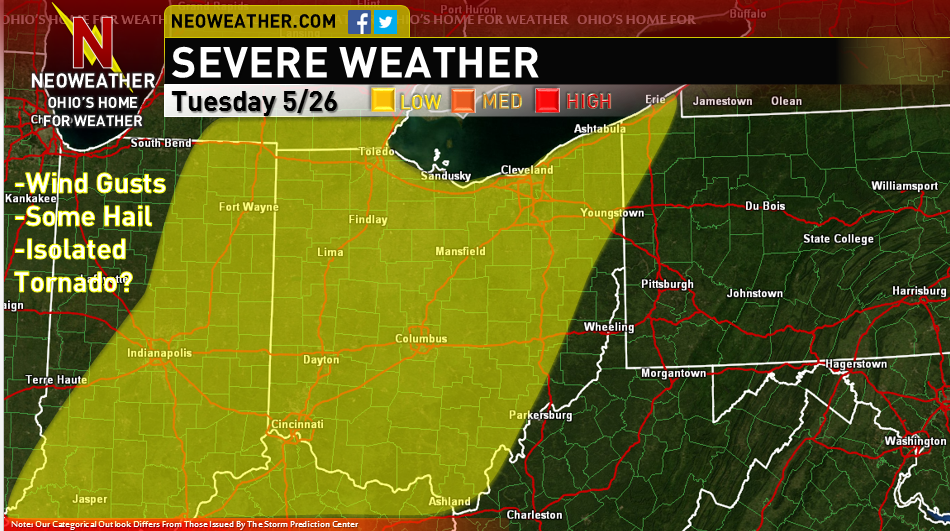
I believe the combination of factors necessitates a low risk across much of the state for Tuesday afternoon/evening. Instability won’t be particularly strong due to weak mid-level lapse rates, however some suggestion for linear storm organization in western OH during the late afternoon/early evening that spreads east and a reasonable low level jet combined with the potential for some discrete cells farther east that may have a window to become supercells with a marginal hail risk and potentially a small tornado risk closer to Lake Erie all supports a low risk. In SE Ohio, the convection will likely arrive later in the evening with weaker bulk shear due to greater distance from the upper level speed max, so I left that area out of the low risk.