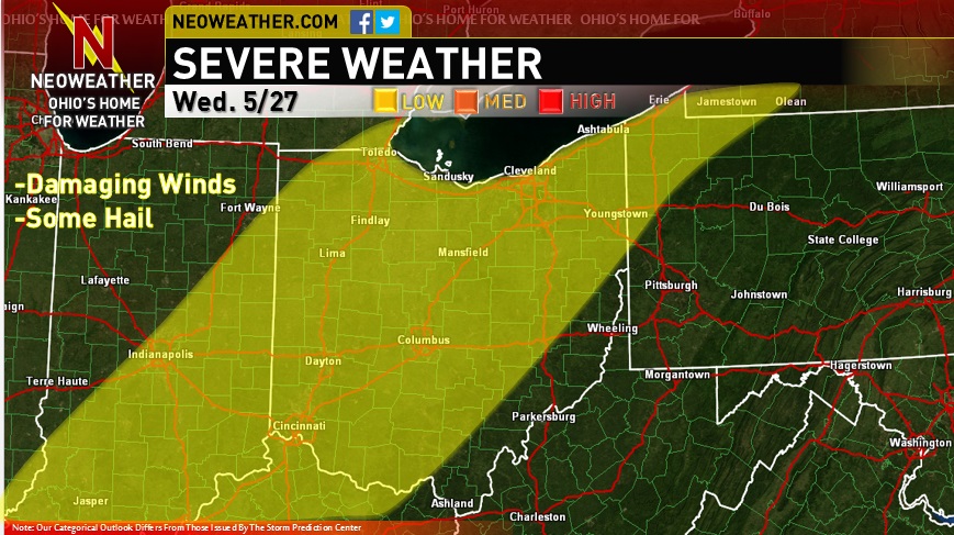
For record keeping purposes, here is a discussion and associated map I created for Neoweather.com regarding the severe threat in Ohio on Wednesday May 27.
Decent large scale ascent in the right-entrance quadrant of an upper level jet streak with some modest height falls as a potent shortwave moves across the Great Lakes. At the surface, a well defined cold front will move into NW Ohio early to mid afternoon and then surge east through the evening.
There is better evidence of an EML on 0z Wednesday observed soundings in the southern Plains…and the radar looks pretty clear between here and there, so we may be able to steepen up mid level lapse rates better tomorrow than today. Low level moisture quality should continue to be decent thanks to a continued large scale southerly flow off the Gulf. Any heating from the sun would result in at least modest MLCAPE values of around 1000 J/KG with values of up to 2000 J/KG possible if we get a good period of solar insolation during the morning or afternoon. PWATs look to decrease some on Wednesday over OH and forecast soundings don’t look as water loaded as Tuesday with a good punch of mid-level dry air evident.
With a flow of around 30 knots at 850mb and 40 knots at 500mb beneath an upper level jet streak providing for over 50 knots of effective bulk shear…along with linear forcing from the cold front and a rather unidirectional flow and the potential for stronger mid-level lapse rates today, good mid-level drying and with any sun some decent low level lapse rates, storms that organize into linear segments along the cold front with a locally enhanced risk for damaging winds appear possible. With strong enough bulk shear for embedded supercell structures within any multi-cell or linear clusters there may be some instances of larger hail. I’d like to see stronger low level winds/turning and better signs for discrete convection to get excited about a tornado risk.
Regardless, think a low risk is plenty warranted for Wednesday. Will re-evaluate this tomorrow morning and decide if any shift in the risk area or potential upgrade to medium is needed.