Not at all a straight forward severe forecast as moisture return/instability issues and timing of better upper level dynamics are both marginal for Ohio.
Two upper level jet streaks evident on water vapor imagery…one over the Four Corners region ejecting into the Plains and another over the Canadian Rockies moving towards the upper Midwest will partially phase and allow for a modestly deepening low pressure across the upper Great Lakes on Sunday. A cold front extending to the south/southwest of this low will remain well west of Ohio, while a warm front moves across the state during the afternoon and evening.
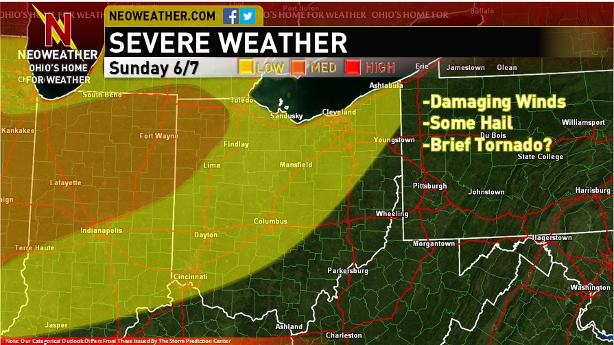
Given the location of the fronts, the potential focuses for convection on Sunday afternoon/evening for Ohio will be the warm front and either outflow boundaries from upstream convection or new convection firing along the southern edge of ongoing convection Sunday morning to our west/northwest.
As for the potential warm front play…questions regarding moisture return reign supreme for this forecast. The NAM and GFS, along with most 9z SREF members return 65F+ dew points by 0z Monday to the western half of Ohio and 70F+ dew points to near the OH/IN boarder. I believe the 70+ dew points are a little overdone when examining 12z Saturday soundings from the AR/LA area and also current surface observations. Regardless, dew points in the mid 60’s seem reasonable in western OH along with modestly steep mid-level lapse rates as a weak EML evident on 12z Saturday soundings and also current mesoanalysis moves east with little convection overturning it could allow for over 1000 J/KG of MLCAPE to develop over the western half of OH by Sunday evening. The GFS and NAM both show some modest upper level divergence associated with the entrance region of the upper level jet streak to our north overspreading OH (especially northern) by 0z Monday and also show a shearing out mid-level vort max, along with associated low level theta-e advection along the warm front aligning over OH Sunday evening. I am torn because with little capping I’d expect this combination to typically fire off isolated to scattered storms along the warm front in the evening, however the models which I think are a little aggressive in returning moisture still struggle to develop anything along the warm front. The 9z SREF shows a 30-40% chance of measurable precip across NE OH in the vicinity of the warm front in the 21-0z window and the “meteorology” suggests that isolated storms should fire in that area during the late afternoon/early evening. Given backed low level winds during the evening, an increasing low level jet during the evening and also an increase in effective bulk shear to 30-40 knots by evening across northern OH, if there is enough instability to fire storms along the warm front in central/eastern OH during the late afternoon and early evening they could become supercells with an attendant large hail/locally damaging wind risks. I believe that the brisk south-southwesterly low level flow, increasing dew points and likely cloud cover will keep the boundary layer well mixed until mid to late evening so I think storms could remain surface based through much of the evening with a brief tornado threat as well. Although the threat is conditional on even getting storms to fire, the risk for supercells with large hail and perhaps a tornado or two in my opinion justifies a low risk all the way through northeastern OH for now with a re-evaluation Sunday morning.
As for the potential storms developing to our west and moving in during the evening…convective allowing models show the storms develop well to our northwest and struggling to even get to NW OH by mid to late evening. Forecast models are notorious for progressing MCSs slower than what actually occurs and also farther north. The 15z RAP suggests that the nose of a strong low to mid-level jet and associated tongue of high theta-e air will likely reach Lake MI/Chicago/perhaps NW IN by 12z Sunday, and I suspect that any MCS that develops over the upper Midwest later today will likely reach that vicinity by early Sunday before likely weakening and leaving either outflow boundaries or allowing differential heating boundaries to develop. In short, I expect new convective development to occur likely farther SE than what a lot of the CAMs indicate…potentially from northern or central IL through northern IN into southern lower MI during the mid to late afternoon.
Strong surface heating combined with modestly steep mid-level lapse rates and more certain moisture return across IL/IN ahead of any clouds leftover from the overnight/morning activity should allow for strong instability to develop across IL/IN that possibly tries leaking into western OH by evening. With little cap…strong instability…improving large scale ascent thanks to the thermally direct circulation in the entrance region of a jet streak passing to the north…and an intensifying low level jet during the afternoon and evening…storms that develop across IL/IN/southern lower MI could become quite widespread and intense. There may be a brief window of discrete development with an attendant hail/tornado risk before the activity inevitably grows upscale into a MCS by early to mid evening. How quickly the MCS propagates is the main question for OH. Although the surface winds may back slightly, the wind profiles look somewhat uni-directional once you get above low levels, which may suggest that the MCS begins training as opposed to propagating east-southeast. On the flip side, good mid-level drying evident across the northern OH Valley/southern Great Lakes may contribute to more robust cold pool development that allows the line to continue sagging southeast somewhat through the evening. Depending on the exact orientation of overnight/early Sunday morning activity, it is also possible that the boundaries that trigger this new convection across northern IN/southern lower MI are more N-S oriented which would allow for upper level flow that is more perpendicular to the triggering boundaries, perhaps allowing for better propagation into SE lower MI and NW OH before things start paralleling each other too much. The MUCAPE gradient and shear vectors does suggest any MCS propagating E to SE into OH during the evening, however, the rather unidirectional flow above 850mb from the WSW gives me some pause.
Given the fairly favorable setup for perhaps initial supercells with hail/a few tornadoes across IL/IN into perhaps southern lower MI followed by a transition to an MCS with a fairly favorable looking atmosphere for damaging winds, feel as though a medium risk is necessary across parts of IL/IN/far NW OH. Farther south and east, the potential for storms to begin training as opposed to propagating more and also the potential for the uni-directional flow to limit moist inflow into the MCS by mid evening onward if the surface flow doesn’t back enough makes the threat much more uncertain. If the boundaries are oriented perpendicular enough to the mid to upper level flow then an MCS that propagates quicker and has a more moist inflow is possible, however we won’t know if that will occur until Sunday morning at some point which precludes placing the medium risk any farther southeast than it currently is. However, if the MCS can in fact propagate farther east or southeast…then a strong low level jet that favors rotating structures within any MCS may allow for a more notable severe threat to occur farther east than the current medium risk.
So, this will need to be re-evaluated Sunday morning, however for now it’s my best stab.
(Map made for Neoweather.com)