
I’ll be home this weekend and the Indians are playing the Tigers in Cleveland, so of course it will rain!!
General Summary:
An unseasonably cold airmass will move into the Great Lakes this weekend. A low pressure system tracking to our east Friday night through Saturday night will spread in a “general” rain Friday night, with some lake enhancement to the rain occurring. Moderate rain amounts are possible Friday night. On Saturday more traditional lake effect rain will take over, with additional moderate amounts of rain looking possible. With a northerly wind on Saturday, the west side should get in on some of this lake effect rain too. More significant lake effect rain looks likely Saturday night as a disturbance increases moisture and instability over Lake Erie and also provides a better focusing mechanism for rain. Moderate to locally heavy additional rainfall amounts are possible Saturday night, including on the west side. On Sunday the atmosphere will gradually warm and dry out as winds shift more westerly, which will gradually push the lake effect to just the east side and cause a decrease in intensity.
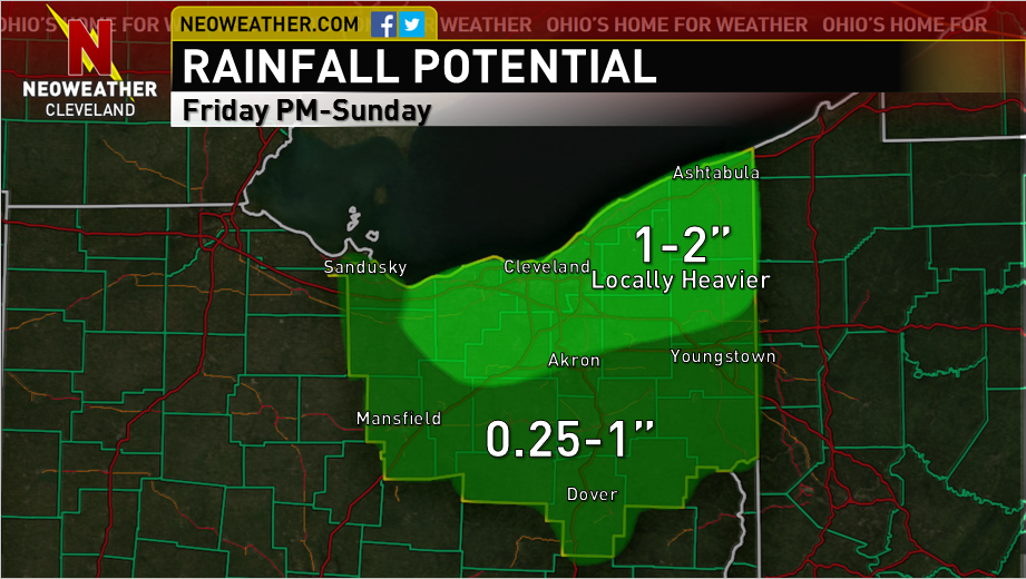
All told, 1-2″ of rain is likely downwind of Lake Erie this weekend with less well south. Locally higher amounts and some flooding are possible where persistent rainbands develop. Outdoor plans will be a wash for much of the weekend.
Meteorological Details:

Pretty complicated forecast starting Friday afternoon in terms of when it will rain and how heavy it will be. A secondary cold front will move across NE Ohio early Friday afternoon with perhaps some widely scattered showers, and by evening some isentropic lift behind the front will overspread the area along with decent large scale ascent from a seasonably strong jet streak and positive vorticity advection overspreading the area. The 0z NAM has a nice surge of mid-level RH in this timeframe. This all should be enough to generate a period of synoptic rain Friday evening…however, the duration and intensity of the synoptic rain is uncertain. The hi-res NAM, Canadian, NMM and ARW for instance are sharper and slower with the trough and farther west with the surface low development Friday night into Saturday and have a 6-12 hour period of synoptic rain, while the standard 12km NAM and GFS are more progressive. The 12z Thursday Euro was slower than the 12km NAM and GFS but faster than the hi-res models and Canadian, and the 0z Euro which I just peaked at is a little slower and farther northwest with the synoptic rain. Given the trend overall over the last few model runs has been to slow everything down, and given the fact that closing off upper lows tend to progress slower than modelled, I’m going to conservatively lean towards the somewhat slower and farther west idea with synoptic rain Friday evening. I could see a general quarter inch of synoptic rain in the CLE area, maybe closer to 0.5″ for CAK with maybe closer to an inch towards YNG.
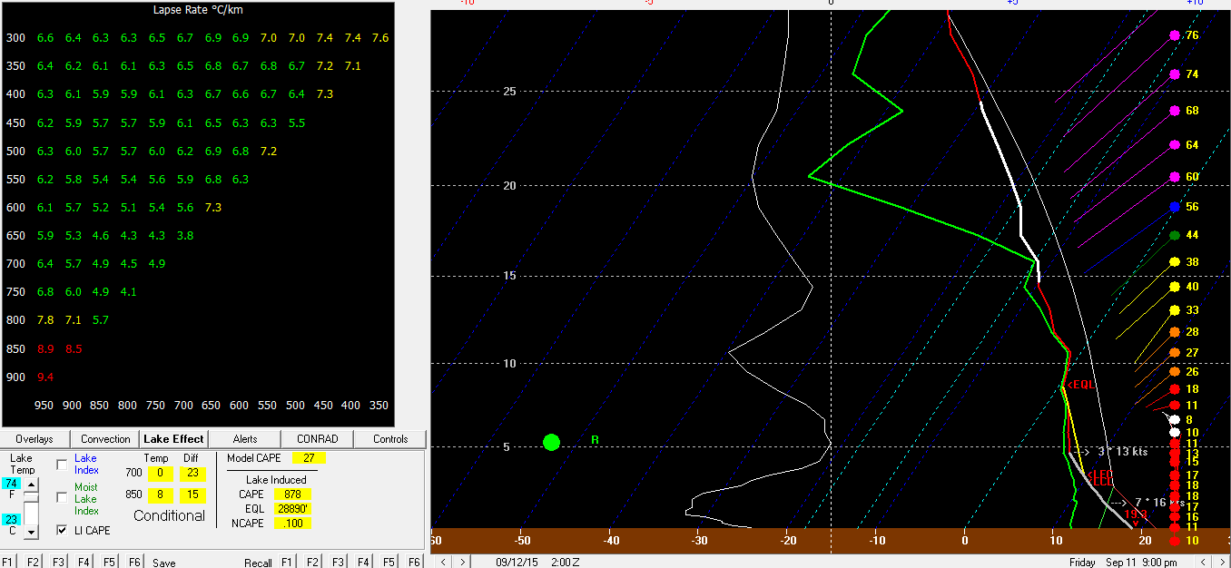
Even if the synoptic rain isn’t heavy in CLE proper, with a NNE low level flow Friday evening and lake induced CAPE values of 500-1000 J/KG and good moisture, some lake enhancement of the rain is likely, which could push rain totals for the Friday afternoon-night timeframe to half an inch to an inch near the lake, with enhancement occurring on the west side too due to an easterly component to the winds. Shear is pretty bad above 5k feet Friday evening (but things do become better aligned later Friday night) which could keep things from getting out of control to an extent Friday night in the lake enhanced rain.
Even the slower models pull the heavier synoptic rain east by Saturday morning, but the surface low tracking farther west and the upper trough closing off and moving east slower allows enough ambient moisture in the low to mid levels to hang back on Saturday for a more pure lake effect rain to continue. The GFS shows winds holding at NE through much of Saturday while the NAM has more due north winds that are somewhat better aligned…both models have lake to 850mb temp differentials of 15-18C during the day Saturday with limitless equilibrium levels. The GFS really dries things out for a while on Saturday while the NAM maintains better moisture…given the NAM is less progressive than the GFS and I’m leaning in that direction (if not even slower than the 12km NAM), I tend to think we’ll stay moist enough on Saturday for lake effect to continue…I also think the winds will gradually back to a more northerly direction on Saturday.
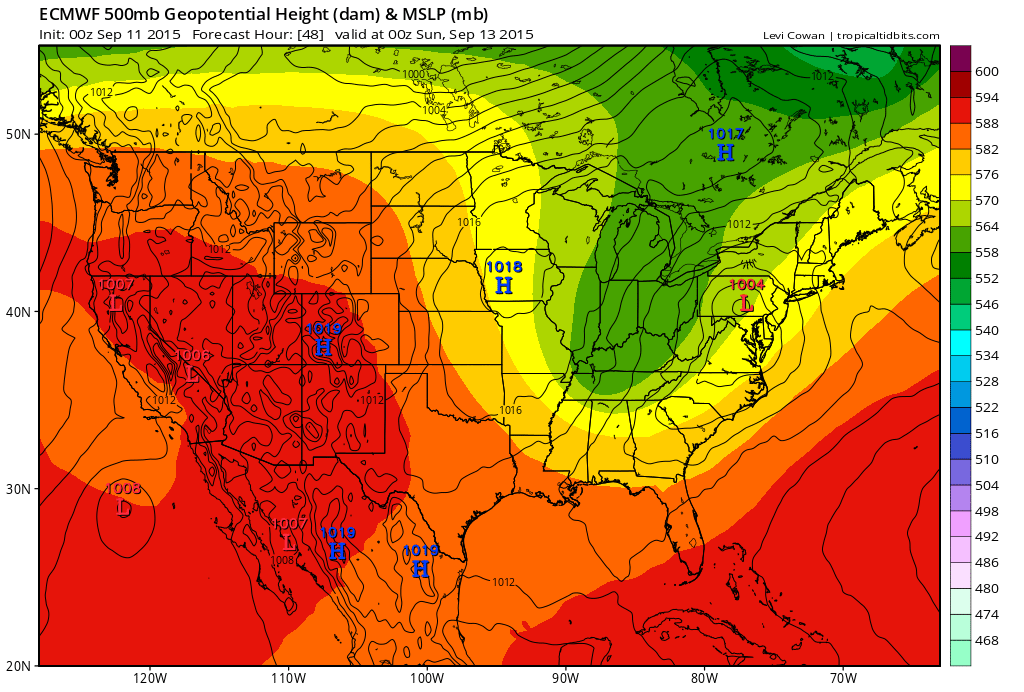
By Saturday evening the Euro, Canadian and some of the hi-res models close off the upper level trough pretty much over OH or just to our northeast (pay sites that have the Euro at a higher resolution and in more timesteps show it occurring) while the surface low tracks towards Lake Ontario. This is a nearly perfect evolution both aloft and at the surface for significant lake effect precipitation with a nearly due north wind.

The 0z NAM develops an astounding thermodynamic profile Saturday evening with over 2000 J/KG of lake induced CAPE for several hours and well aligned winds below 10k feet. Most models slowly drop an inverted trough across Lake Erie Saturday night in a mainly north flow with an increase in moisture and as seen above unbelievable instability. The NAM and GFS are both a bit dry Saturday night, however the 0z Euro keeps 70% or higher RH at 700mb in place through 12z Sunday which would easily do the trick. The combination of a cyclonic flow…a surface trough…orographic lift in the N or NNW flow and extreme lake induced CAPE suggests that heavy rain is possible Saturday night in the primary and secondary belts.
Conditions start to deteriorate for lake effect on Sunday as the low and trough begin moving east, but the winds will gradually turn more westerly and enough moisture and lake induced instability hangs around for light to moderate rain to continue much of the day in the Snowbelt.
All told, between the shot of synoptic rain and some enhancement Friday night…off and on lake effect on Saturday…the potential for heavy lake effect Saturday night…and at least some lake effect continuing through much of Sunday…I don’t see how areas within 20-30 miles of the lake from Lorain and Medina points east don’t see at least 1″ of rain from Friday PM through Sunday, and amounts of over 2-3″ in several areas would not surprise me. 1-3″ won’t cause much flooding, but if it gets any higher there will be issues.
That said, I was “lucky” enough to have the forecast earlier this evening for the website I help with and included this rain map for the weekend…in the text associated with the map I mentioned locally 3″ or more of rain. Honestly after the 0z models came in slower with everything (which means more synoptic rain and better lake effect conditions hanging on for longer) I think this map may be conservative. If the hi-res models are right and we get 1-2″ of synoptic rain Friday night, weekend totals could locally push 4″+ in spots!
In addition to all the rain…although a northerly flow isn’t ideal for waterspouts over the nearshore waters due to weaker convergence over the lake, the thermodynamic profile strongly supports waterspouts this weekend. Also, the NAM develops enough CAPE for small hail with any storms that roll in off the lake Saturday evening.
