
General discussion:
A very disorganized Tropical Storm Erika will pass near or over Puerto Rico tonight into Friday morning and near or over the Dominican Republic on Friday. Exactly how close Erika passes to Hispaniola will have a large impact on how strong the storm is this weekend as it moves over the Bahamas. The environment when combined with potential interaction with mountainous terrain suggests that Erika will either maintain its strength or weaken through Friday. Warm water temperatures, low upper level wind shear and good upper level outflow over the Bahamas this weekend into early next week suggests that if Erika can maintain itself as a tropical cyclone over the next 24 hours that intensification could occur over the Bahamas. Because of this, people in the Bahamas are urged to continue monitoring the progress of Erika; however, we could see anything between rain and breezy conditions with an open tropical wave if Erika loses its closed circulation due to interaction with Hispaniola to a hurricane by Sunday or Monday if Erika is able to maintain its identity until the weekend. We will know much more Friday night.
As for the track forecast and potential US impacts early next week, the storm will likely move somewhere over the Turks and Caicos Friday night into Saturday and through the central Bahamas and northern Bahamas Saturday night into Sunday on a west-northwest heading. Steering currents over the Gulf of Mexico, Florida and off of the southeast US coast will be rather weak Sunday into early next week, however, a stronger storm would likely turn north and potentially stay just east of Florida, while a weaker storm may continue moving more west-northwest and move into the Florida peninsula and/or into the Gulf of Mexico early next week.
The track forecast for Erika starting Saturday will be strongly influenced by the intensity forecast. Due to considerable uncertainty regarding the intensity of Erika after Friday and weak steering currents in the region, the track forecast is unusually uncertain at this point in time. In general I am leaning towards the farther west/weaker solution at this time, however.
Necessary Disclaimer: The thoughts in this post are mine alone and should not be used for any decision making purposes. For official forecasts, go to:
www.weather.gov (National Weather Service)
www.nhc.noaa.gov (National Hurricane Center)
Heed any advice from local emergency management officials this weekend and into early next week.
Although the forecast is less than clear cut, interests in the Turks and Caicos, central and northern Bahamas, the entire Peninsula of Florida and the southeast US coast from North Carolina southward should closely monitor the progress of Erika over the next several days.
Meteorological Discussion:

Erika remains a fairly disorganized tropical storm as it was two days ago when I last posted; as expected. However, Erika thus far has held its own despite moderate westerly shear. There is a lot going on right now as I type this, and the next day of Erika’s life will have significant impacts on what happens to it down the road. I will likely re-iterate this several times in what is going to be a long write-up, but this is a complicated forecast with large implications for the SE US coast, Florida and still possibly the eastern Gulf of Mexico.
Infrared satellite imagery shows a large burst of disorganized convection well south of the low level circulation, and a smaller burst near St. Croix. Where the low level circulation is currently located is in doubt; the 8PM EDT/0z NHC advisory had the center at 16.7N, 64.7W and an initial recon pass found a very lose circulation in a similar area:

However, as can be seen above on their second pass there was no evidence of a circulation in that vicinity! They fixed what I believe is a weak low level eddy for their second and third pass. Radar and surface observations suggest that another low level center of circulation formed very near St. Croix in this same general timeframe, with the pressure at TISX (airport on St. Croix) falling quickly to 1006mb and then quickly rising after the feature went by. Several wind gusts over 50 knots were recorded on St. Croix. Here is the old “recon center” on radar and the newer possible center:

As this center moves towards Puerto Rico over the next few hours, surface observations on the island will give us a much better idea on whether or not this is a closed off surface center…although radar seems to strongly suggest as much. This potential center appears to be have a heading of slightly north of due west based on radar, probably around 280. Such a heading would take Erika directly into Hispaniola early Friday.
After discussion with others and continued observations as I’ve typed this, I believe that the center that moved over St. Croix is just a very strong eddy rotating around a very broad low level center. I believe recon is fixing another, weaker eddy as the center. After analysis of satellite loops I will use the NHC’s 11PM EDT/3z center location of 16.6N, 65.3W as my initial center point.
It is possible that the heading of Erika continues to change; Wednesday night into Thursday morning, a consistent strong burst of convection south of the surface center pulled the center south, resulting in a due westerly heading that took Erika much farther south than forecast. Thursday afternoon the burst of convection south of the center waned and a new burst formed east of the center, resulting in almost a due northwest motion for several hours, followed by a more due west motion over the last couple of hours per the TJUA radar. An average motion over the last 12 hours, overall, is probably about 285, and I’ll use that for the initial motion in my forecast. It is possible that convective bursts continue to cause unexpected wobbles in the motion of the low level center.

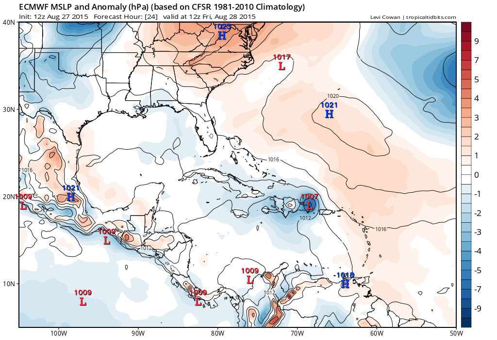
Erika is currently being steered by a strong sub-tropical high pressure to its north. The combination of this high being a little bit stronger than expected and convection consistently firing south of the center has resulting in the track being farther south than anticipated over the last day or so. As Erika reaches the western edge of the nearly stationary sub-tropical ridge, it should gradually gain a stronger northerly component of motion.
The 18z GFS, 12z ECM, 0z early hurricane track models, current motion and current steering flow suggest that in the near term Erika will move over western Puerto Rico and over a good portion of the northeastern Dominican Republic over the next 24 hours, emerging over the Turks and Caicos late Friday night into Saturday morning. It is possible that Erika sees a NW tug as it hits the Windward Passage late tonight thanks to frictional convergence as the surface center passes Puerto Rico and I will show that to an extent on my track forecast. How exactly the low level center interacts with the mountainous terrain of Hispaniola and if bursts of convection cause continued wobbles in the motion of the center do add some uncertainty to this forecast, but I will bring Erika or whatever is left of it out to the Turks and Caicos late Friday night, as I believe the convection will become focused north of Hispaniola and attempt to drag the low level center (if there is one left by that point) farther north.

The environment immediately ahead of Erika features moderate to perhaps strong westerly shear due to 1) a shear axis trailing a TUTT to the northeast of Erika and 2) another upper low near western Cuba.
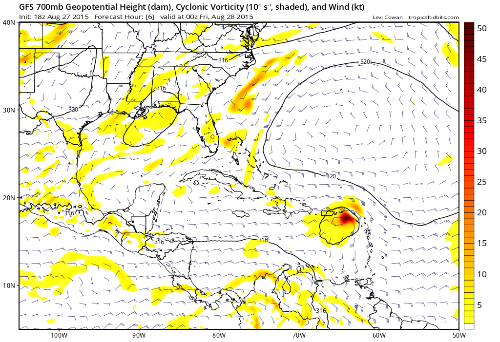
I suspect that the interaction with the mountainous Hispaniola and shear over the next 24 hours will likely cause Erika to at least temporarily degenerate into an open wave…however, the GFS and Euro both maintain a robust mid-level circulation past Hispaniola, which could foster redevelopment over the Turks and Caicos. This can be seen clearly on the 18z GFS depiction of 700mb height/wind/vorticity over the next 36 hours:
The environment by this weekend as discussed in my previous post is still expected to be quite favorable for re-intensification of Erika thanks to very warm water temperatures, low shear and good upper level divergence/outflow over the region:
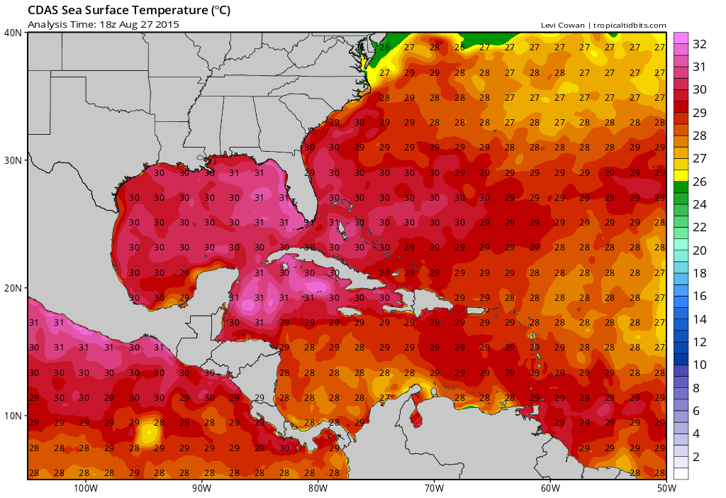
Sea surface temperatures ahead of Erika increase to 29-31C (84-88F) over the Bahamas and off the Florida and southeast US coast, and as I discussed in my previous post these warm waters exist to deep depths, meaning there is plenty of fuel for a tropical cyclone in this area and that cooler waters wouldn’t quickly upwell under the system and slow intensification.
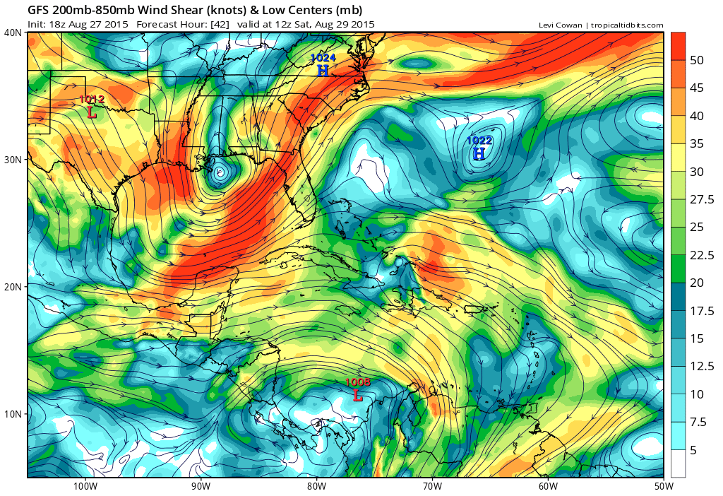
By Saturday morning, the GFS still continues to start weakening shear over Erika as it moves over the Turks and Caicos. There is still some light to moderate westerly shear over the system at this time, but note how shear is beginning to relax near the system, with winds starting to fan out away from it, indicative of good outflow. The 12z Euro also shows a similar idea Saturday morning:

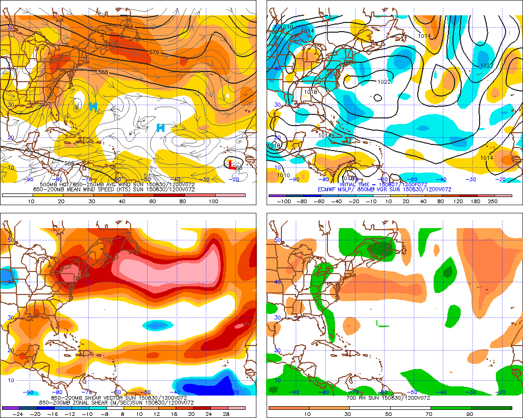
By Sunday morning, both models show an *outstanding* upper level environment over the Bahamas as Erika passes through, with strong outflow and low shear thanks to an upper level anti-cyclone over the storm; this image is a classic pattern for an intensifying tropical cyclone, with an upper level anti-cyclone over the storm and a jet streak ventilating the storm and providing for strong outflow:

The 12z Euro looked similar (although it is noticeably faster with Erika and is approaching Miami Sunday morning as a minimal tropical storm):
This all adds further intrigue into both the intensity and track forecast. Let’s again explain why the track forecast Sunday into early next week depends strongly on how intense Erika is by that time:

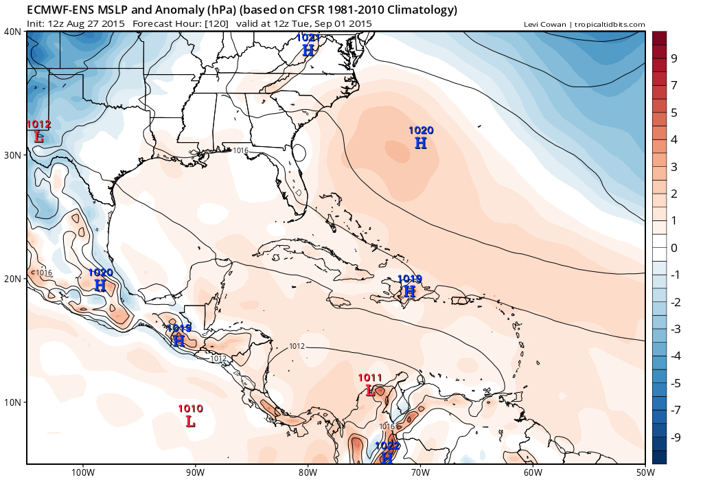
The Sunday evening steering currents on the 18z GFS in the lower levels (what would steer a minimal tropical cyclone) show a very modest weakness in the ridging off the SE US coast, but in general show reasonably strong ridging into the SE US that would keep an open wave or weak tropical cyclone moving generally WNW or NW. However, the 500mb map features a larger weakness in the ridge due to a weak upper level trough over the Mississippi Valley, with the ridging centered farther east than at 850mb…suggesting that a stronger system steered by a deeper layer of winds would likely start turning more northerly quicker than a weaker one:

The trough in the upper levels is very weak and essentially cut off from the flow thanks to a strong –PNA driving the polar jet into Canada, so predictability of this feature may still be questionable; the European ensembles over the last two days of runs have trended slightly weaker and farther northeast with this trough, and have trended slightly stronger with ridging in the western Atlantic for the forecast time verifying Sunday morning:

On the balance, this likely means that a stronger storm would likely recurve slightly closer to the coast. Whether or not a strong storm hit the coast may depend on when exactly it got stronger. If the system did recurve off the coast, the pattern would support a strong storm moving slowly off the SE US coast, but likely would then whisk it out to sea before it got into the Mid-Atlantic:

Although the steering flow off the SE US would likely be very weak early next week, IF Erika got strong in time to recurve east of Florida, the flow around the ridge would likely move it slowly northeast before it eventually started getting caught up in the westerlies off the Mid-Atlantic coast. We will have to monitor the forecast depth of the trough over the NW Atlantic over the next few days to ensure that a recurve away from the Mid-Atlantic and New England would remain the favored solution for a stronger Erika; if that trough becomes shallower or shifts farther east it could open the door for a track farther north…however, a lot would have to go very well for that to happen, and at this point I’m treating it as a very low probability event.
Here is some of the latest guidance on Erika:
0z early track models:

18z GFS ensembles:

JUST IN 0z GFS through Sunday evening:

12z ECM:
12z ECM ensemble mean valid day 5:
Overall, putting together the intensity forecast considerations and track forecast considerations, here are my final conclusions:
A significant interaction with Hispaniola is likely over the next 24 hours thanks to slightly stronger ridging north of the storm than previously expected and convection firing down-shear of the center dragging the center farther south than expected at times over the last two days. The combination of moderate to strong wind shear and interaction with the mountainous terrain of Hispaniola over the next 24 hours will in my opinion either cause Erika to generate into an open wave or weaken into a very broad and disorganized circulation, especially when considering the very marginal organization as discussed above.
Steering currents and all model guidance suggest a turn slightly more towards the northwest by Saturday taking Erika through the Turks and Caicos and north of Cuba. Although factors strongly support re-intensification of Erika over the Turks and Caicos and Bahamas Saturday into Sunday, it will likely take a day or two for the low level center to reorganize and allow proper intensification to begin. Due to this, Erika will likely remain weak and steered by the somewhat faster and more easterly low level flow through the weekend. The fact that the Euro has been fairly consistent with a faster/farther left track and the new GFS with data from an upper air surveillance mission inputted into the model’s initialization gives me more confidence in this idea. With this said, I will lean towards the GFS timing a little bit as current satellite loops suggest the 12z Euro is running several hours too far…and it seems too fast this weekend when the steering flow weakens some. This gives Erika roughly 48 hours to organize before potential impact with Florida.
Given limited time to re-organize and what I think will be at least a 24 hour process for the low level circulation to tighten back up after passing Hispaniola, I currently think it’s unlikely Erika intensifies beyond tropical storm strengthen before hitting Florida. Due to the faster/weaker/farther left solution I’m favoring, I am not going to show a recurve east of Florida for my track forecast for Erika. Erika would likely begin to stall over Florida and possibly begin recurving there as it begins rounding the southwesterly edge of the low level ridging. If Erika stalls over Florida and slowly weakens, low-level ridging re-intensifying could result in a slow down and bend back west with the track.
My forecast will call for degeneration into an open wave over the next 12-24 hours and re-intensification into a tropical storm before impact with Florida, followed by weakening. There are still alternative solutions on the table; a quicker re-organization after passing Hispaniola could still result in quicker intensification and a recurve just east of Florida with an increased threat to the southeast US coast as a hurricane, but I am leaning against that. It still can’t be ruled out that Erika never regains tropical storm status and heads into the eastern Gulf as an open wave, where it may battle marginal wind shear and have further trouble re-organizing.
Map:

Track positions/intensity:
Initial: 11PM EDT Thursday: 16.6N, 65.3W. 40 knots (TS)
12 hours: 8AM Friday: 17.6N, 67.5W. 40 knots (TS)
24 hours: 8PM Friday: 19.0N, 70.0W. 30 knots (open wave)
36 hours: 8AM Saturday: 20.4N, 73.0W. 30 knots (open wave)
48 hours: 8PM Saturday: 22.0N, 75.6W. 35 knots (TS)
60 hours: 8AM Sunday: 23.9N, 79.0W. 40 knots (TS)
72 hours: 8PM Sunday: 25.8N, 80.0W. 50 knots (TS) (nearing landfall)
96 hours: 8PM Monday: 27.6N, 81.6W. 35 knots (TS) (inland)
120 hours: 8PM Tuesday: 29.0N, 83.0W. 30 knots (TD) (inland)
Wind probability table:
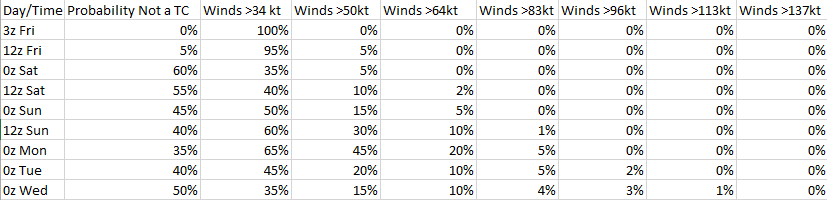
Note: The wind probability table doesn’t assume a track down the center line (although that is considered “most likely” and reflected in the probabilities). The probabilities take into account solutions that are less likely but still possible, such as a system intensifying quicker and staying east of Florida (which is why category 3 and 4 probabilities, while small, increase some while the overall forecast calls for weakening). There is a chance that a system is a classifiable tropical depression but not a tropical storm and not dissipated, which is why the dissipated and tropical storm or greater probabilities don’t always add up to 100%.
