
Just a quick write-up with this one as I am back at school and a little busier today…
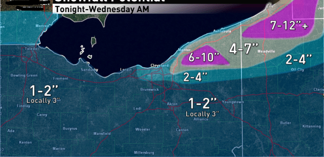
There’s a period of weak to moderate lift late tonight and Tuesday morning with warm air advection ahead of the cold front associated with the clipper for several hours that should produce light snow. There appears to be a decent potential for a brief snow squall along the arctic front Tuesday morning. Between all of this think everyone should ring out 1-2″ of synoptic snow. A little concerned that with the lift focused in the snow growth zone that high ratios may allow the snow ahead of the arctic front to over-perform a bit which could push a few areas over 2″ so I went 1-2″ with locally up to 3″ for the synoptic snow area wide.
For the LES portion of the event winds become aligned out of the WSW by late Tuesday morning behind the arctic front which should allow a strong single band to form over the lake and head towards SW NY initially. Winds slowly go WNW by Tuesday evening which should push the band onshore in the primary Snowbelt. Moderate to extreme instability, high inversion heights and good moisture including a fetch from Lake Michigan support heavy snow rates in the band. Winds over the lake go WNW or even NW briefly Tuesday evening which will try to push the band into parts of northern and eastern Cuyahoga County, but high pressure and cooling temps overland will try to keep the band closer to the shore. The winds should start pushing the band back northeast up the shore late Tuesday night into Wednesday morning.
BUFKIT shows strong lift in the snow growth zone Tuesday night into Wednesday in the LES (a “cross-hair signature” as BUF frequently calls it) suggesting heavy snow in the band and what should be good convergence over the Snowbelt supports a good band…so amounts of 6-10″ should easily be doable where the band is most persistent. Right now I have this over northern Geauga as the winds over land will try to keep the band a little farther north than some models try to take it. Erie County and SW NY will also do well. Cuyahoga County has high bust potential either way as WNW or NW winds over water will try to push the band into the county, so I did put more in northern and eastern Cuyahoga to account for this but it could be higher if the banding can firmly settle into there. If winds on land are too SW the banding may largely stay NE of Cuyahoga County so as I said…bust potential either way.
