
General Discussion:
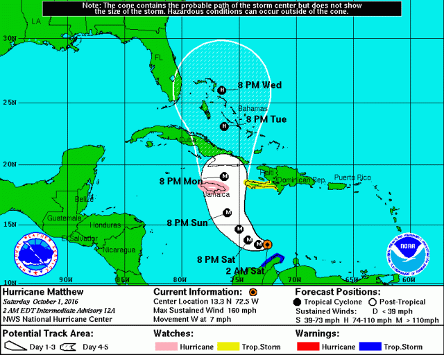
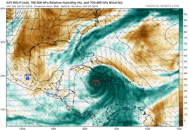
Hurricane Matthew has intensified much faster than anticipated over the last two days, and as of Friday evening became a category 5 hurricane. This is the first category 5 hurricane in the Atlantic Basin since Hurricane Felix in 2007. Matthew has begun slowing and will make the much anticipated northward turn Saturday night into Sunday. This turn will take Matthew over or near Jamaica Sunday night into Monday.
Fluctuations in intensity are likely over the weekend, but Matthew will be at least a category 3 hurricane as it makes its closest approach to Jamaica; the potentially for life threatening flash flooding/mudslides, storm surge flooding, and significant wind damage is increasing on Jamaica. Jamaica may cause Matthew to lose some intensity, but Matthew is still expected to be at least a category 3 hurricane Monday night into Tuesday as it moves into eastern Cuba. Again, a significant risk for life threatening inland flooding, storm surge flooding, and destructive wind damage will accompany Matthew over eastern Cuba. Haiti may also see gusty winds and very dangerous inland flooding; a slight jog east in Matthew’s track could bring devastating hurricane conditions to Haiti as well.
After moving over Cuba, Matthew will move north-northwest into the Bahamas on Tuesday and slowly move north across the island chain. Cuba’s higher terrain will weaken Matthew, but a favorable environment for re-intensification looks to exist over the Bahamas, so Matthew will certainly be a hurricane and potentially re-intensify into a major hurricane as it passes over the Bahamas through mid-week.
The track after hitting the Bahamas and future threat to land…including the US East Coast from Florida to New England is highly uncertain. It is possible that Matthew even drifts near or over the Bahamas for a few days. Interests in a large swath of real-estate along the East Coast need to continue to monitor the progress of Matthew.
Please check forecasts from the National Hurricane Center, your local Weather Service office, and heed advice of Emergency Management officials when making hurricane-related decisions.
Meteorological Discussion:

From a tropical storm with a nearly exposed low level circulation Wednesday morning to a category 5 hurricane Friday evening; Matthew’s transformation in the face of some weak to moderate shear and perhaps a little bit of dry air in the general vicinity of the hurricane has been nothing short of impressive. Friday afternoon saw a small eye emerge, with the eye warming to warmer than 0C with a solid ring of very cold cloud tops surrounding it by Friday evening; this was all indicative of a rapidly intensifying hurricane that did in fact max out the Saffir-Simpson scale. This intensification was completely unexpected to me when I last posted Wednesday evening; I thought that some shear and dry air would at least slow inner core development/organization through Friday, with potentially rapid intensification at some point over the weekend. Sometimes in sheared tropical cyclones, convection firing and rotating up-shear of the center can offset wind shear and allow for intensification. This occurred here, and an otherwise favorable thermodynamic environment for persistent and very deep convection allowed Matthew to go “all the way.”
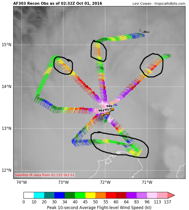
Unfortunately, there aren’t any recent microwave images as of this writing to further diagnose the current condition of Matthew; however, there is recon. Usually, these very strong tropical cyclones with tight inner cores are living on borrowed time; it’s inevitable that a larger outer eyewall will eventually form and choke off the much smaller and more intense inner eyewall. This usually results in the system seeing its maximum wind speeds decrease, its pressure increase, but its radius of max winds expands; this is commonly known as an eyewall replacement cycle (ERC). Data from the most recon flight into Matthew is beginning to indicate a secondary wind maximum well away from the very tight inner core. Although this isn’t yet an outer/secondary eyewall, and the inner core is still very much alive and well, this signals that an ERC will probably occur within the next 12-24 hours…or by Saturday night.
Although it’s possible that Matthew intensifies a bit further before the ERC begins, signs Friday evening are pointing to the intensification leveling off; the eye has begun cooling on IR satellite imagery, and the pressure drop during the last recon mission started to slow. My guess is that Matthew sits at borderline cat 4/5 status through Saturday, before weakening to borderline cat 3 or 4 status Saturday night into Sunday as an eyewall replacement happens.
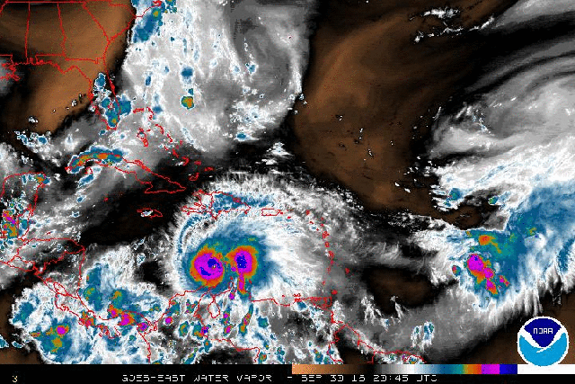
Water vapor imagery still shows some pros and some cons to the environment around Matthew—yes, obviously Matthew maximized the positives which offset and relatively minor negatives. There is still a large scale southwesterly flow aloft to the southeast of a trough over the Gulf of Mexico, with an upper low embedded within that trough well north-northwest of Matthew. This has allegedly imparted 10-20 knots of southwesterly shear on Matthew over the last couple of days, and will continue to do so; however, Matthew’s organized and robust inner core has fended off this weak to moderate shear. There is also some dry air ahead of Matthew…not a ton, but it’s still there, and if Matthew undergoes an eyewall replacement cycle it may become a little more susceptible to this dry air and shear. Also of note is the overall very divergence upper level flow and strong outflow over Matthew, which likely combined with the very warm water temperatures to allow Matthew to generate significant enough convection to essentially fight off any southwesterly shear. Obviously, inflow off of South America is not drawing enough dry air into Matthew to negatively impact the storm at this point.

The intensity forecast for Sunday and Monday…which is critical to Jamaica, eastern Cuba and Haiti…is not quite straight forward. As I mentioned above, it is highly likely that an eyewall replacement cycle occurs by Saturday night and causes weakening. Normally, eyewall replacement cycles have a hard time completing and allowing the cyclone to return to its previous intensity if shear, dry air, or land interaction interfere with the cyclone. If conditions are highly favorable, sometimes an ERC can complete after 24-36 hours.
The above loop shows the GFS forecast potential vorticity on the 355k surface; basically, it shows where upper level troughs/lows/TUTTs are, because those features are denoted by higher vorticity near the tropopause. The model correctly identifies a PV streamer just NW of Matthew in the early hours of the run, suggestive of a somewhat stronger SW flow aloft near the hurricane right now. Although the hurricane doesn’t show it, there is still weak to moderate SWrly shear affecting it. The model then fractures this PV streamer and/or pushes it away as strong convection and latent heat release with Matthew causes heights to rise over the hurricane, which causes anti-cyclonic/negative vorticity advection around the hurricane, literally pushing away the higher vorticity upper level troughs. This lessens the shear by Sunday and Monday, potentially leaving an environment which could allow for some re-intensification after the ERC.
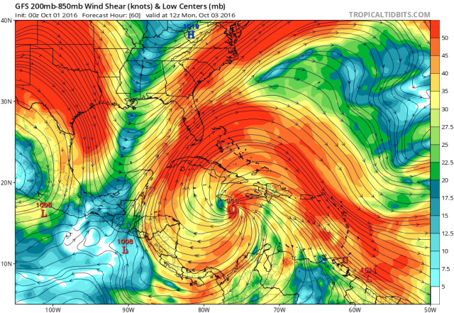
The result of all of this on the GFS is an essentially perfect upper level environment for intensification by Sunday and Monday as Matthew churns towards Jamaica. Whether this will come to fruition is unknown, but the GFS and to an extent the Euro have been extremely insistent on the weak to moderate shear currently affecting the cyclone weakening over the weekend…that’s why I initially expected the most substantial strengthening to occur on Saturday-Sunday. Note the diverging upper level winds away from Matthew, with Matthew perhaps being near the right-entrance quadrant of a weak jet streak, which could provide for a very robust poleward outflow channel. In addition, even if some southwest flow aloft persists in the region, Matthew will turn from the WSW track it is on now to the NNW over the next couple of days, meaning the effective shear on the cyclone will decrease. This all suggests the potential for Matthew to continue to produce very deep and persistent convection as it moves over extremely warm waters over the northern Caribbean.
The other factor to Matthew’s intensity forecast will be dry air; there is dry air northwest of Matthew, which the GFS did properly initialize with, and it will be interesting to see if the ERC can allow the storm to become more susceptible to dry air than it has been thus far. The GFS has the system mixing out any dry air by Sunday, but enough of a dry air intrusion during the ERC may make it hard for it to complete before it starts running into mountainous terrain.
My guess…based on an eyewall replacement happening Saturday-Saturday night, but the environment improving and possibly allowing it to complete just as it approaches Jamaica…is that Matthew will be a category 4 when it hits Jamaica. Can something I don’t foresee happen and cause that guess to be off by a category? Definitely. Does that make a difference? Not really, because this looks like an extremely dangerous situation for Jamaica either way. How Matthew interacts with Jamaica will help determine its intensity when it plows into eastern Cuba Monday night into early Tuesday, but it will in all likelihood be at least a category 3 when it hits eastern Cuba. Depending on if Jamaica can slow down Matthew at all, the very warm waters and seemingly very favorable environment could certainly allow for a category 4+ hit on eastern Cuba. It is still worth noting that Haiti will be on the right (strong) side of a quite possibly major hurricane, and a modest jog right would have extreme impacts on Haiti and the Dominican Republic.
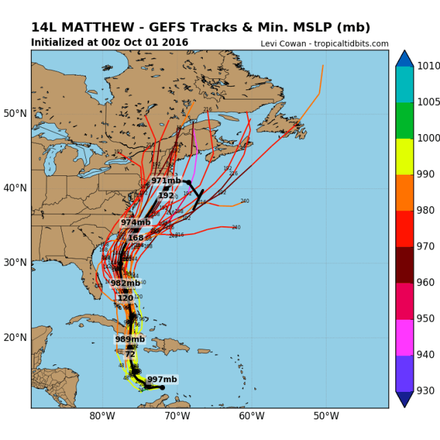
Matthew will likely emerge as a category 2 hurricane in the Bahamas…where it goes from here is highly uncertain, and has impacts on a lot of people. We know the Bahamas will be affected…and it’s possible the hurricane moves slowly over the island chain while re-intensifying, causing significant issues in the Bahamas. After that, possible US or even Bermuda impacts are still unknown.
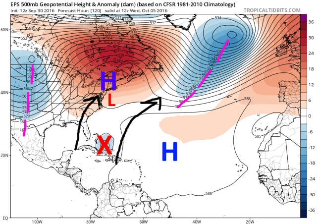
The key features in this forecast are all visible on the above map from the Friday afternoon run of the European ensembles. The big features are a trough moving east out of the western US, ridges over the central Atlantic and also over the Northeast, and a cut-off low slowly moving off of the East Coast. Without the upper low off the coast ahead of Matthew, the ridging doesn’t have a weakness, and the hurricane is forced to go northwest towards the Southeast coast. However, the upper low is there, which causes a weakness in the ridging; between the upper low and central Atlantic ridge, a weak south-southwesterly flow would likely cause Matthew to move slowly north-northeast until it got caught up in the westerlies and accelerated east-northeast, away from land. Such a scenario would still be a close shave for the Southeast coast and possibly Florida.
The forward speed of Matthew early next week may be critical, as a storm that moves north quicker would be more prone to the weakness in the ridging and escape out to sea…while a slower storm may stay south while the upper low moves away and ridging tries to build in more solidly to the north of the storm…trapping it farther south and possibly steering it slowly towards land.
An alternate scenario is that Matthew does get drawn north a little bit quicker by the upper low and the weakness in the ridging just off the East Coast, but then phases with the incoming trough from the west (if it goes negatively tilted) and is pulled back west (not as extreme as Sandy).
Basically, this all adds up to a bunch of moving parts and a bunch of possibilities, and at least a non-zero US threat from Matthew. We can try to break down what the models are showing and what may be favored:

The European suite largely is slower with Matthew, and traps it over the Bahamas/off of the Southeast or Florida coast through next week. The European ensembles, however, are fairly progressive with the weather pattern, with a fast flow over the NE Pacific, with frequent shortwaves crashing into the western US. The pattern doesn’t favor a deep longwave trough over the eastern US, and suggests that the shortwave/trough moving out of the west may not dig down enough to pick up Matthew, and would instead kick it out to sea. Although yes, the tilt of the shortwave on the ensemble mean is negative, the base of the trough is north of where many members have Matthew, meaning it likely wouldn’t pick up the storm. Many members show slow movement over the Bahamas…a few do drift Matthew into the SE US coast, likely due to the cut off low moving away and ridging building…and a small few do show a faster track and allow Matthew to hook into the Northeast…but most members do ultimately show a track out to sea currently:

This makes sense given what we saw on the pattern of the ensemble mean…but does show that theirs is some uncertainty in both the shorter term movement of Matthew, the cut off moving off of the coast, and even the trough moving in from the west.

The GFS (and to a decent extent its ensembles) show a different solution. The GFS suite, generally shows the cut off low exiting and weakening quicker, allowing for ridging over the Atlantic to expand west, shrinking the weakness in the ridging and pushing it west. This already allows for a westward nudge in Matthew’s track, which has possible implications on Florida and the Southeast coast. The GFS is also coming in more aggressive with the trough moving out of the west, and is moving Matthew quicker than the European suite.
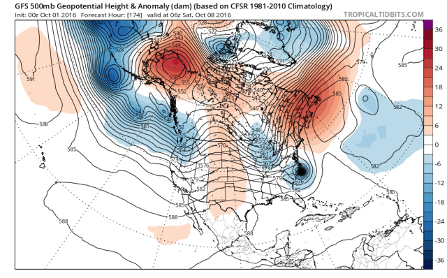
As we move forward, the stronger ridging, farther west and faster Matthew, and more aggressive trough on the GFS ultimately allow the trough to capture/phase with Matthew and accelerate it towards Long Island and New England. Ultimately, the trough is a little bit too far north to phase with Matthew, but the ridging prevents Matthew from going OTS and keeps in moving north, which then puts it in a better position to be captured by the trough.
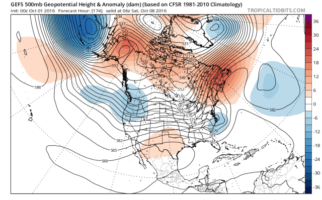
The GFS ensembles have some similarities and differences to the operational model. The ensemble members generally are quicker with Matthew, like the op, and have stronger ridging ahead of it as well. One difference is that there’s disagreement on the incoming trough’s timing, strength, and orientation, which may play a role in whether or not Matthew can hook back towards the coast or escapes just to the east.
Although the GFS ensemble mean 500mb map doesn’t look quite like the op’s does, there are still a number of members that also hit the coast like the operational does.
What can we deduce from all of this?
The first variable that affects where Matthew goes in the longer term is where it goes in the shorter term. The European suite is still slower than the GFS on Matthew’s track into early next week; given the European won with the farther west/slower idea early on, and given weakening steering currents as a break in the ridge develops, I’m tempted to lean towards the slower solution going forward.
Other variables include how quickly the cut off exits the coast and weakens, and whether the pattern is amplified enough for the incoming trough to dig and go negatively tilted.
Given I am favoring a slower forward motion in the short term…and think the pattern looks a bit progressive still…I still lean towards the Euro suite which keeps Matthew off the just Southeast coast and eventually takes it out to sea. With this said, predictability of things such as a tropical cyclone’s location in 5 days and cut off lows isn’t good, so there is still a larger chance than I’d like of Matthew drifting into the Southeast or getting pulled into the northeast…and that can’t be ignored until the forecast becomes clearer.
