
General Discussion:
Please always consult the National Hurricane Center, your local weather service office, and emergency officials when making hurricane related decisions.
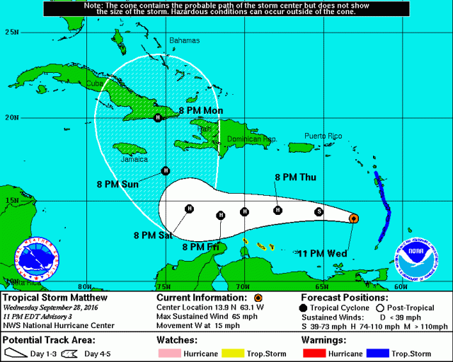
Tropical Storm Matthew brought heavy rains and strong winds to a large portion of the Lesser Antilles on Wednesday and is now briskly moving west through the eastern Caribbean. Matthew is expected to pass north of South America through Friday as it gradually intensifies; tropical storm conditions may occur on the ABC islands and also the northern tip of Colombia Thursday night into Friday, especially if Matthew tracks a bit farther south than the forecast from the National Hurricane Center (pictured above).
Over the weekend, Matthew is expected to slow and turn to the northwest and eventually more due north. My guess is this may happen a little bit farther west than what the National Hurricane Center shows. Regardless, Matthew is expected to intensify more substantially over the weekend and may threaten Jamaica, Hispaniola, and/or Cuba as a strong/likely major hurricane Sunday into Monday.
Where Matthew goes into early next week is uncertain (though I will specify below in the meteorological discussion), but interests in the Bahamas, Florida, Bermuda, and the Southeast US need to closely monitor the progress of Matthew. Although less likely to be impacted, Mexico and the Gulf Coast should at least keep an eye on the storm over the next several days due to high forecast uncertainty.
Meteorological Discussion:

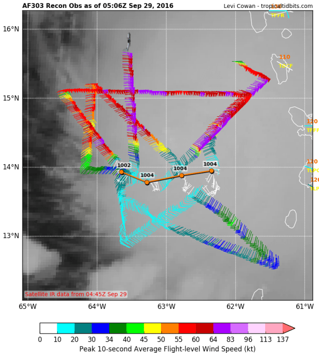
Just before Invest 97L reached the Lesser Antilles, recon found a closed circulation and tropical storm force winds, resulting in the official formation of Tropical Storm Matthew. Since that time, recon has found 55kt surface winds and up to 70kt flight level winds, indicating that Matthew is a fairly high-end tropical storm.
The satellite presentation is impressive, but actually a little bit misleading in my opinion. The CDO has become very symmetrical Wednesday evening, with a nice area of colder than -70C cloud tops. There is also strong outflow evident in all quadrants of the storm; at first glance, this looks like a very impressive storm. Unfortunately for Matthew, the low level and mid level centers do not appear to be completely aligned; radar imagery from the Lesser Antilles shows that there isn’t really any inner core structure yet, with the vast majority of the convection running behind the low-level center:

In addition, Airforce recon also suggests that the center is moving west quickly, and is near the western edge of the CDO feature on satellite. This all suggests that the low level center is outrunning the mid level center; the centers aren’t completely detached, but this setup does not favor rapid organization:
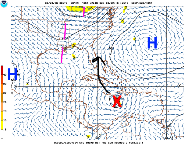
What is causing this disorganization and whether or not the cyclone will quickly become more vertically stacked/organized is a bit unknown…water vapor imagery does show an upper low to the NW of Matthew, and the SSWrly flow to the SE of this low may be causing some weak to moderate SWrly shear on Matthew. There is decent outflow in pretty much every quadrant, normally a sign that shear is weak, however the outflow may if anything be slightly restricted in the SW quadrant, a sign that there may be a little bit of shear from that direction.

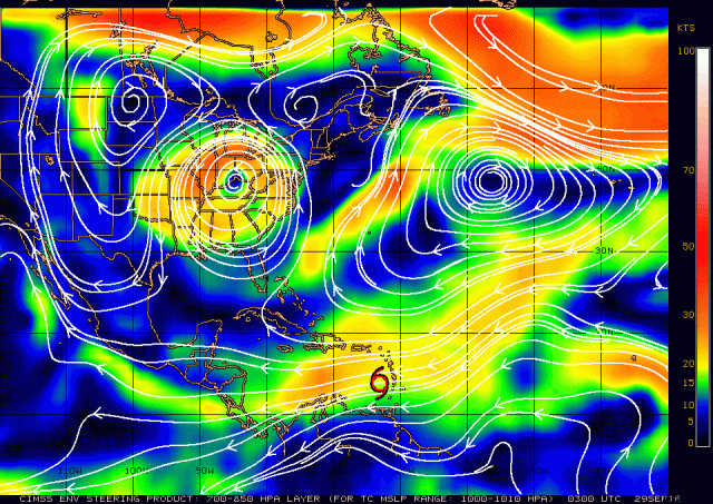
CIMSS shear analysis shows that Matthew may be close enough to this upper low for some shear to impact the storm, however it incorrectly analyzes the upper-level anti-cyclone to be well south of Matthew, which causes artificially high shear values to be analyzed over the storm. The anti-cyclonic outflow emanating almost perfectly in all quadrants suggests the anti-cyclone is still fairly well coupled with Matthew, and that the shear isn’t 20-30 knots as CIMSS indicates:

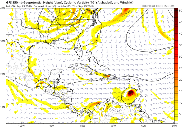
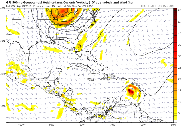
The larger culprit for the somewhat slanted center of Matthew may be the low level trade winds causing the low level center to outrun the mid-level center…on the very short range GFS (used more as a demonstration than a forecast), the winds at 850mb (roughly 5000 feet above sea level) in the eastern Caribbean are from the east at around 30 knots, while the winds at 500mb (roughly 18000 feet above sea level) are from the east at 10-20 knots…resulting in effective westerly shear:
This low level trade wind acceleration is common in the eastern Caribbean, and has been a hindrance to many developing tropical cyclones historically. This problem may persist through Thursday and Friday before subsiding into the weekend as Matthew moves farther west.
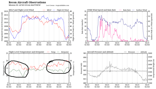
Another potentially issue limiting the symmetry of Matthew’s convection may be somewhat drier low level air on the western side of the circulation; recon found dew point depressions of near or greater than 5C/9F near and west of the circulation, which may also be limiting convective development on the western side of Matthew.
All in all…the combination of a slanted center, which may not correct until Friday or Saturday due to perhaps some weak SWrly shear caused by an upper low and also strong trade winds…combined with low level dry air, which may also not correct until Friday or Saturday due to inflow off of South America, which is not a moist inflow…suggests that Matthew may only gradually intensify through Friday. With that said, Matthew is already a high-end tropical storm, is producing robust convection, is a large system, and has strong outflow while moving over warm water. It’s definitely possible/if not likely/ that Matthew gradually organizes enough to intensify into a minimal hurricane by Friday or Friday night, with more substantial intensification thereafter when current negatives to intensification go away.
As for the track over the next few days; Matthew is currently rounding the southern edge of sub-tropical ridging extending southwest to north of Hispaniola. This will cause Matthew to continue to briskly move to the west or even south of due west for the next couple of days. This has been expected and is well agreed upon by our models. The uncertainty increases over the weekend.
Matthew is expected to intensify more substantially over the weekend, altering which steering flow influences it the most. A weaker storm, such as Matthew at the time of this writing, follows the low level flow closely, while a strong storm, such as a major hurricane, follows the mid to upper level flow more than the low level flow. As discussed in my previous post, the flow in the low, mid, and upper levels by this weekend will be substantially different:
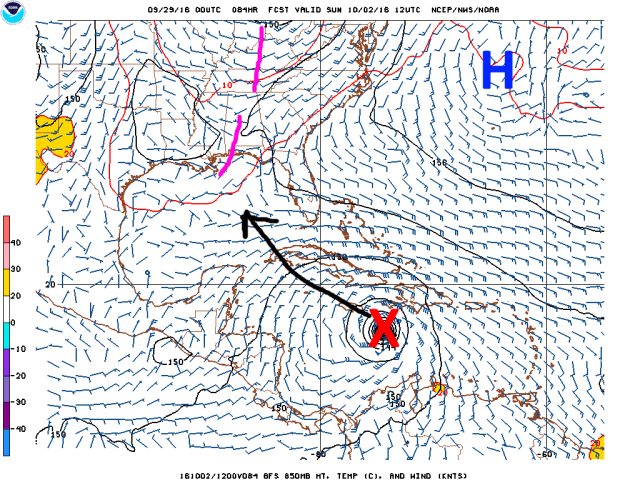
A cut-off upper level low over the Ohio Valley/Great Lakes/Northeast through this weekend will weaker the sub-tropical ridging along the East Coast and into the Gulf of Mexico. A very weak upper level shortwave trough may further weaker the upper level ridging over the Gulf. The ridging will remain stronger in the low levels. Matthew will in all likelihood be a hurricane and quite possibly a major hurricane by this weekend, so the 500mb flow, if not a bit higher up is probably a fair approximation for what Matthew will follow. There is good agreement that if Matthew is following the flow around 500mb or so this weekend that it will reach the break in the sub-tropical ridging just as it passes Hispaniola, likely resulting in a slowing and rather sharp turn towards the NNW, taking it dangerously close to Jamaica around Sunday. More on the track in a bit.
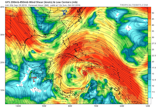
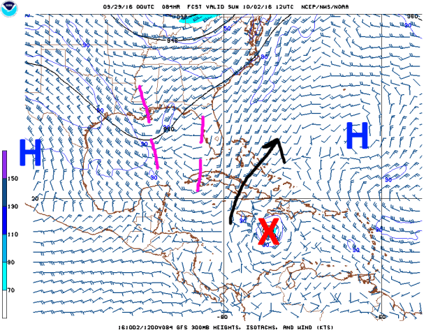
Conditions appear conducive for intensification…possibly significant…over the weekend as Matthew eventually slows and turns N/NW. The upper trough over the Gulf of Mexico is expected to provide an outflow channel for Matthew, with the anticyclone remaining coupled with the storm and providing for low shear and good outflow in all quadrants. This has been consistently shown by the GFS (pictured) and Euro, and given the lack of strong upper level troughs/upper lows in the way of Matthew to possibly impact its upper level anticyclone and outflow, I don’t see a reason to go against this idea.
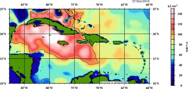
As mentioned the other day, the water in the Caribbean is very warm, and that warmth extends down a significant depth towards the northern and western Caribbean. A large tropical cyclone with favorable upper level winds over such warm waters for a prolonged period of time is normally a recipe for a significant hurricane.

The one wild card that may determine whether or not Matthew eventually struggles to become a category 3 hurricane by Monday, or rapidly intensifies into a category 4, will be dry air and eventual inner core structure. The western side of Matthew’s circulation is currently plagued by at least some dry air as discussed above, and inflow off of South America may continue to pump at least some dry air into Matthew’s circulation through Friday. With low shear, once Matthew moves away from South America it may be able to mix out this dry air fairly quickly. Once a tropical cyclone develops an organized inner core, it is usually for dry air to impact the core of the cyclone in the absence of wind shear. It’s possibly Matthew develops an organized inner core by Saturday and has a full two days to intensify over very warm waters, in a low shear environment, before possibly running into the Greater Antilles. However, it’s possible Matthew struggles for a little bit longer and can’t get its act together until 12-24 hours later (Saturday night or Sunday), in which case it may just run out of time to become a major hurricane before interacting with higher terrain.
The track past Friday-Saturday is still the major wild card with Matthew, and will ultimately determine which of the Great Antilles are eventually threatened, and what, if any, land farther north will possibly be threatened. The track forecast is still a battle between the GFS and Euro suite, and the range of solutions is still fairly large:
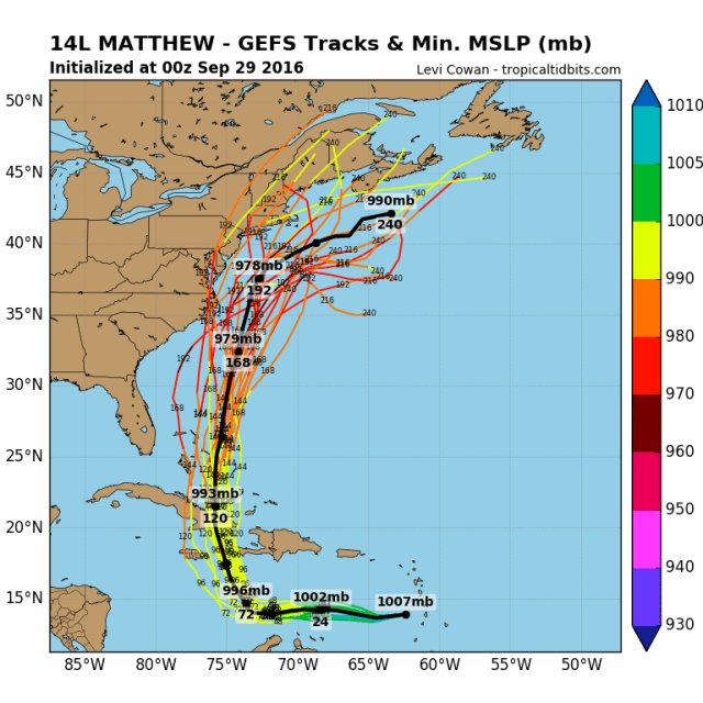
Wednesday evening’s GFS ensembles generally take Matthew through the Windward Passage Sunday night, with a couple of members slightly farther west. It is worth noting that this is a couple hundred miles farther west than the GFS ensembles were Monday night. None of the ensemble members were this far west Monday night, showing that the GFS ensembles have an issue of not being dispersive enough and capturing all possible solutions. With that said, they’re still the second best ensemble system in the world at this time.
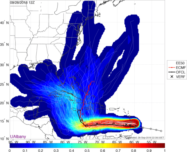
Wednesday afternoon’s European ensembles (courtesy of Brian Tang at the University of Albany), much as was the case Monday, are generally farther west than the GFS ensembles and have a much greater range of solutions. The ensembles agree in a turn north, somewhere between 70 and 80W, but disagree on what happens thereafter. It’s also worth noting that a turn north at 70W crushes Hispaniola, while a turn near 80W threatens the Cayman Islands and western Cuba, while a turn in the middle may have significant impacts on Jamaica. There are subtle but important differences between the GFS and European suites, both in the large scale pattern around Sunday/Monday and in the shorter term track of Matthew; both will likely impact where the turn will occur.
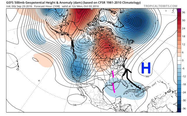
Wednesday evening’s run of the GFS ensembles shows the much discussed weakness in the sub-tropical ridging along the East Coast, due to a cut-off low drifting around through this weekend across the Ohio Valley/Great Lakes/Northeast. The ensemble mean agrees well with the op in taking Matthew through the Windward Passage or over eastern Cuba, and the weakness in the ridging would allow Matthew to track east of Florida/but through the Bahamas from here.
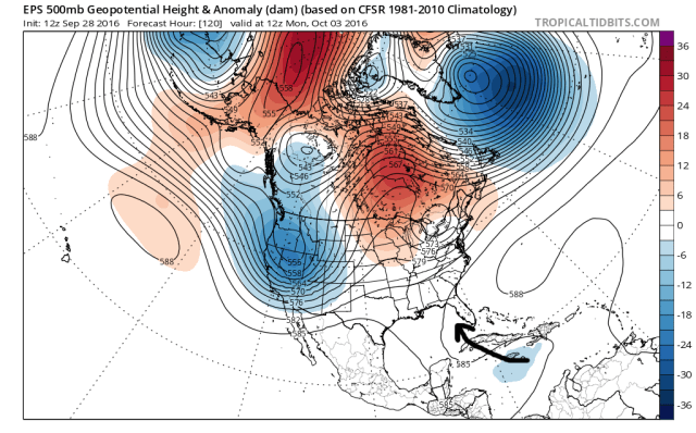
The European ensembles, by contrast, have less of a trough over the Gulf of Mexico, have the sub-tropical ridging (note the 588dm contour) extending a little farther west, have Matthew farther south on the mean and likely would allow a future track much more threatening to Florida. It’s also interesting to note that the Euro suite is a bit more amplified with the pattern over the CONUS, with a deeper trough over the west and stronger ridge over the Midwest towards Hudson Bay.
The question is, which is right?
In terms of the short term track differences, I have to give the nod to the Euro suite (a little faster and farther south). Some negatives for intensification suggest Matthew may follow the faster trade winds and also stay a bit farther south than the GFS forecast through Friday or so, before more substantial intensification over the weekend allows Matthew to slow down and begin turning right. It’s tougher to call which suite is right with the larger scale weather pattern in 5 days…there has been an ever-so-slight trend to weaken the Gulf of Mexico trough over the last couple of days in both suites, but in general both suites have remained rather insistent in their ideas. Verification numbers suggest siding with the Euro, but the differences are so small that it’s tough to call.
Either way, I do agree with the Euro ensembles generally later turn of Matthew, which does have future implications, including an increased threat to Florida.

As we head deeper into next week, the NE US upper low is finally expected to get kicked east as upper level ridging builds in. Where Matthew is at this time will be critical to figuring out where it goes next week; if it hooks north quicker, it will likely get kicked out to sea. If it is still milling around near Cuba or in the northern Caribbean as the ridging builds back in, it could resume a more WNW motion and threaten the Gulf of Mexico. A middle ground solution is the weakness created by the upper low is still enough to keep Matthew from getting trapped in the Gulf of Mexico, but that the storm hooks north far enough west to still threaten Florida and possibly the East Coast.
This is NOT a Sandy like situation where a trough will help pull the storm west. If it turns north quickly enough, the threat to the East Coast is over and this goes out to sea. However, if the storm tracks farther west, turns north later, and slows down longer, it may well get trapped under the ridge.
At this point, it is still too early to reasonably say where Matthew may track next week. There are a ton of Euro ensemble members that have the storm drift on either side of Cuba for a few days before moving again later next week, with only about a quarter of them hooking Matthew north fast enough to keep it east of the US East Coast. If Matthew organizes much quicker than I think through Friday, we see an earlier turn north, with Hispaniola in much greater danger. Normally, this synoptic pattern would favor a recurve between the Bermuda and the Carolinas, however, Matthew’s rather far south starting point makes that call much less certain.
Right now I still like my call from my previous post of the turn north occurring at a time where it’s more likely to threaten Jamaica and eastern Cuba. There’s still very much a threat for Hispaniola (especially Haiti), due to heavy rains and possibly damaging winds depending on where exactly Matthew tracks…and the Cayman Islands should also watch this one…after that I’m still very uncertain. My guess is this gets caught up in the weakness in the ridging and stays just east of the Florida and Southeast coast, while moving through the Bahamas slowly as a hurricane. However…that’s still very uncertain, and there is a non-zero threat for the Gulf Coast, Florida Coast, and really the entire East Coast. The common pattern for a Gulf Coast hurricane involves a trough over Texas and a ridge along the East Coast, with the western edge of the ridging being a good bit farther west than in this instance. The common pattern for an East Coast hit is either 1) the break in the ridging being right along the coast or just a tad inland, with a storm coming from the east turning to the NW and the N and running into the Carolinas or 2) a negatively tilted trough over the Ohio Valley pulling a storm NW into the coast.
This pattern doesn’t quite match any of those…but Matthew’s starting location, and lack of a strong trough to guarantee a recurve, make this an uneasy call. With the models generally bullish on ridging building over the Northeast next week, if Matthew hasn’t escaped out to sea by Wednesday…a very real possibility…it may drift around near the Bahamas, or near or just off of the Florida and Southeast Coast, over warm waters and in a fairly decent environment. Although the pattern doesn’t quite look right for a US hurricane hit…it’s not far off and still bears watching, as the weather pattern 7-10 days out is prone to errors, sometimes quite large, even in our best forecast models.
I’ll try to update again Friday or Saturday.
