
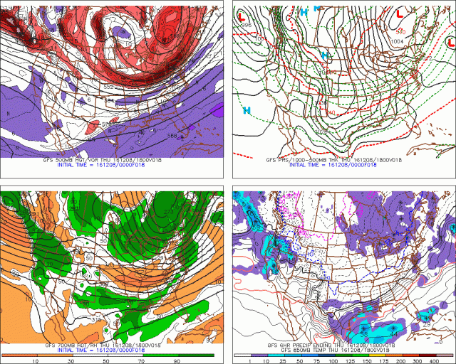
An unseasonably deep trough will move across the Great Lakes Thursday through Saturday, bringing with it a deep cold air mass, sufficient moisture, and a broad cyclonic flow across the warmer than average Great Lakes. This will result in the second lake effect snow event downwind of Lake Erie of the season. This one will be of longer duration, favor lighter winds, a longer fetch, and colder temperatures, likely resulting in much more substantial totals than the first one (2-6” in NE OH).
Snow amounts of over a foot appear quite possible by Saturday in the higher terrain of southern Lake County and northern Geauga County, as well as inland northwest Pennsylvania. Eastern Cuyahoga County may also see heavy snow at times and decent storm totals. Amounts will drop off quickly outside of the Snowbelt, but a rouge snow band may drop accumulating snow in parts of northern Lorain County and western Cuyahoga County on Friday.
Map:

Technical Discussion:
As the cyclonic flow begins developing over the region Thursday morning, a band of snow will likely develop over the lake and hug the lakeshore in Lake and Ashtabula Counties, before moving into Erie County PA and Chautauqua/Cattaraugus County NY. The band will likely hug the north half of those counties. We’ll actually be in a region of subsidence with mid-level drying through early Thursday afternoon behind a shortwave trough moving over the region early Thursday morning, however the long fetch and moderate instability will likely allow decent accums to being across parts of NW PA/SW NY on Thursday with this band.
By Thursday evening, a weaker shortwave or vort max is expected to drop across Lake Erie between 5-10PM. This will cause inversions to rise and mid-level moisture to increase, while also bringing a surface trough and wind shift with it. The winds will shift from WSW in the low levels to more of a W Thursday evening as this trough pushes through. This will likely push heavier snow into the NE OH lakeshore Thursday evening and push it a bit farther inland of NW PA and SW NY. With the passage of this first trough, inversion heights will increase to around 10k feet and moisture depth will increase to around 8k feet, allowing the intensity of the lake effect to increase:

Although the shear looks bad, it’s much better aligned over the lake, and will result in strong convergence near the lakeshore as stronger, W to WNW winds over the lake run into weaker WSW winds over land. The stronger WNW winds over water will try to push the snow inland some Thursday evening, however the WSW winds over land suggest the better snow will hug extreme NE Cuyahoga County, Lake County, Geauga County along and north of US 6, the northern half of Ashtabula County and into Erie County through Thursday evening. The instability and moisture support snow rates of over 1” per hour assuming convergence can develop as it appears it should and focus better snow in the aforementioned area.

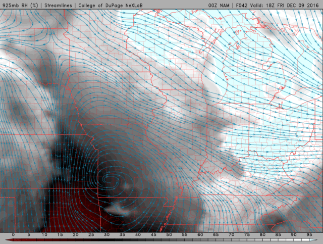
The 12km NAM does show this zone of convergence, extending from as far west as Lorain County into inland Erie County PA, with the convergence stronger farther east. This favors moderate to heavy snow in the northern NE OH primary Snowbelt and into a good chunk of Erie County PA (and also the ski-country in SW NY) Thursday night. The convergence will not move much for several hours, so several inches could be picked up in these areas Thursday evening into the overnight, with locally over 8” in NW PA/SW NY through 4am Friday where a longer fetch, more terrain, and seemingly stronger convergence could contribute to heavier snow.
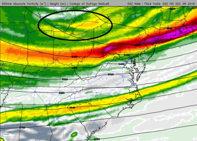
Between 4am and 10am Friday, another shortwave will rotate around the larger trough to our northeast. Although the upper level shortwave stays to our northeast, the surface reflection will move southeast across Lake Erie as a well-defined trough. This will initially really increase convergence along the lakeshore early Friday as winds back a little bit on land ahead of the trough, and turn more WNW to even NW over the lake behind the trough. The upper level support for this surface trough will stay to our northeast, and the surface trough will be moving into high pressure nosing into the Ohio Valley, so it’s questionable how quickly this trough pushes through.

Regardless of how quickly the trough pushes through Friday morning, conditions for lake effect will go from “pretty good” to “pretty outstanding” Friday morning, with moisture depth improving to 10k feet, inversions rising to 13-15k feet, and winds in the low levels weakening a little bit and increasing residence time over the lake. Lake to 850mb, 700mb, and 500mb differentials will push or exceed 20C, 30C, and 40C Friday morning as the trough pushes through…all of these values are “extreme” and support a few lightning strikes with any good snow bands Friday morning near the lake. Snow rates of 2” per hour are quite possible with the band along the surface trough Friday morning.
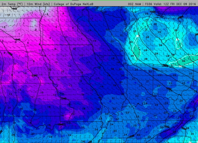
The question is, how quickly does the trough and band push south? I suspect the heart of the primary Snowbelt…far NE Cuyahoga, southern Lake, northern Geauga…will see a few hours of very good snow ahead of and along this trough given the W to slightly S of due W wind direction ahead of the trough. From there, winds only go WNW behind the trough, with the best upper support remaining well NE, and with surface ridging nosing into the Ohio Valley. This suggests that the trough will not push south super-fast, and may not push the snow band farther south than northern Lorain County/southern Cuyahoga County/the Geauga/Portage County border. This may drop a quick 1-4” on much of the Cleveland metro as well as southern Geauga County, inland Ashtabula County, and southern Erie/most of Crawford County PA given likely intense snow rates and gradual progression of the trough and accompanying snow band.
Behind the trough for late Friday morning and afternoon, shear is weak, the flow is a favorable WNW and not too strong, instability remains extreme with high inversion heights, and moisture depth remains respectable. Decent lake effect snow should continue. The big questions for Friday behind the trough will be whether some sort of band can maintain itself across the southern Snowbelt and allow for a more focused area of moderate to heavy snow, and whether or not we can get any upstream connections. The environment is pretty freakin good for lake effect snow on Friday, so it’s just a matter of capitalizing on it:
The WNW low level flow does suggest a continued connection off of southern Lake Michigan through the day Friday, which would suggest some decent snow in the Cleveland metro and primary Snowbelt in NE OH. This flow would take the Lake Superior connection (which is actually rather common) into NW PA. The 850mb flow is a bit more NWrly and takes the southern Lake MI connection south of Lake Erie and takes the upper lakes connection into the Cleveland metro and Snowbelt. The well aligned low level flow off of lower Lake MI and some convergence along the way suggests that connection may contribute to snow in the Cleveland metro on Friday, with upstream lakes keeping things going in NW PA/far SW NY during the day behind the trough.

Convergence will probably weaken some Friday with an absence of a trough to our NW, and also with temps on land warming up some and decreasing the temp differential over the lake a little bit. Regardless, remnant convergence from the morning band and some remaining lake to land temp and wind differentials should allow some loosely organized snow to persist on Friday across the Cleveland metro and southern Snowbelt. I don’t expect a firehose band, but with such a good thermodynamic profile and some pre-seeding from Lake Michigan there could be good bursts that add up to at least a couple to few inches during the day Friday behind the trough. This will be the best chance for parts of Lorain, Medina, Summit, Portage, southern Trumbull and Mahoning Counties (particularly northern portions of this corridor) to see some accumulation.
A good question is how much of a break will the northern primary Snowbelt see on Friday during the late morning and afternoon. In NW PA and SW NY, there doesn’t look to be strong convergence, but there may be decent connections to Lake Huron and Lakes Superior/Michigan (northern). This may cause snow to shut off along the shore (outside of any upstream connections) but decent snow could keep going in the higher terrain, particularly in any upstream connections. In NE OH, I expect northern Ashtabula and Lake Counties to see snow really slow down and possibly shut off Friday late morning and afternoon…however, convergence and orographic lift just inland may allow at least snow showers to continue in far southern Lake County, Geauga County, and southern Ashtabula County in the higher terrain…though they may become less organized. This may support a few inches behind the trough in the higher terrain of Erie and northern Crawford County in NW PA and a couple inches in far southern Lake County/northern Geauga County in NE OH through Friday afternoon…with perhaps a few inches a little farther south in NE OH where convergence tries to persist.

There may be an interesting setup Friday night into Saturday morning as ridging builds closer and slowly backs winds. There is pretty good agreement on a good southern Lake Michigan connection developing Friday evening, with the potential for strong convergence developing near the central lakeshore as temps cool on land and as winds on and go light and southwesterly:
This could favor a more organized convergence band re-developing Friday evening and persisting into Saturday morning. With a W or WNW wind initially, this band could initially develop over northern Cuyahoga and central Geauga County before slowly shifting north later Friday night into Saturday morning. Conditions will remain favorable for decent LES through Friday night before degrading Saturday morning:
Upper level temps warm a little bit, but the low and mid levels remain plenty unstable and moisture Friday night for heavy snow rates should a band form. Any upstream connection would only increase the likelihood of heavy snow Friday night, and the somewhat weaker low level flow may also favor heavyier snow. Winds suggest this band will shift to northeastern Lake, northern Ashtabula, and Erie PA counties by sunrise Saturday. Snow rates of 1-2” per hour may be possible under this band, with the potential for the band to persist long enough to drop a few or locally several inches Friday night. Winds should shift enough to finally push the band out of Erie County PA by mid to late Saturday afternoon, bringing this event to a close.
As for accumulations…I expect 2-6” through mid Thursday afternoon in northern Erie County PA and into northern Chautauqua/Cattaraugus County NY with a WSW flow band that should start developing by morning and become fairly intense by afternoon. Coastal Lake and Ashtabula Counties may see a light accumulation from this.
By Thursday evening I expect the snow to intensify and push a bit farther south, and this could produce another few inches (3-6”?) through Thursday evening in Chautauqua/Cattaraugus County NY, Erie County PA and Lake and northern Ashtabula County in OH as the first trough pushes through and winds go more westerly. Far NE Cuyahoga and northern Geauga may also see light accumulations through Thursday evening. These accumulations in NW PA and SW NY should be focused a bit south of where the initial band will dump through mid-afternoon.
Thursday evening into the overnight will likely see the band hold steady or shift ever so slightly farther south with a WSW surface flow on land and WNW flow over the lake. Lake effect conditions gradually improve, and this could produce another few inches (2-6”) through 4AM Friday in far NE Cuyahoga, northern Geauga, Lake, northern Ashtabula, and Erie PA (into inland SW NY). The band will intensify ahead of the next trough and then gradually push south into the Cleveland metro and southern Snowbelt. This whole process could produce a few inches in the northern Snowbelt initially while the band intensifies early Friday, and then 1-4” in the southern Snowbelt and Cleveland metro through mid Friday morning as the band swings south.
Friday late morning through afternoon may feature the snow becoming less organized…however upstream connections, longer fetch and upslope into NW PA may produce a few more inches in this timeframe, with perhaps a few inches where the remnant convergence band and southern Lake MI connection set up into parts of the Cleveland metro (possibly western and southern suburbs) and southern Snowbelt.
The band Friday night may produce a couple inches in eastern Cuyahoga/southern Geauga and up to several inches in northern Geauga and Lake/Ashtabula and into NW PA as it re-flares and then very slowly shifts NE. NW PA may see some more Saturday morning before it finally ends.
All together…given the potential for multiple instances of banding with moderate to heavy snow, and perhaps even continued accumulating snow showers between periods of banding, think there will be over a foot in the typical hot spots in southern Lake/northern Geauga and inland NW PA. Inland NW PA may see locally up to 2 feet where any upstream lake connections develop on Friday. Drew the sharp southern cut off from northwestern Cuyahoga County southeast through far northern Summit, northern Portage, and Trumbull Counties. Winds get WNW for a time, but lake aggregate troughing tends to be stronger when the lake is warmer, and ridging building in on land suggests the trough/convergence band Friday may not make it extremely far inland. For the Cleveland metro this is tough…may be a couple of windows for banding near the shoreline late Thursday night through Friday evening which could produce a few inches, even down to the shore. Farther east, there may be a good shot of banding through very early Friday another shot Friday night into early Saturday, so amounts along the shore could be decent. There could be graupel near the lake given how warm the water still is which may hurt ratios near the shore and keep higher amounts inland a bit. Inland could see 15-18:1 ratios with temps below freezing for the event.
High res models are iffy on amounts…BUF WRFs look good through early Friday but don’t run out any farther. NMM is similar to this idea but struggles to develop an organized band at times and is lighter on amounts…ARW seems lost. 4km NAM isn’t far off from this idea but also struggles to organize bands and shows lighter precip than you’d expect given the setup, and hence shows much lighter amounts. The 12km NAM and SREF consistently show snow, perhaps in a band, in the Snowbelt, and these low-res models combined with the setup do argued for a prolonged heavy event with good totals in the heart of the Snowbelt. We’ll see.
