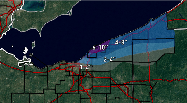
I don’t have time to put together a write up, but here are some quick thoughts for Thursday evening-Saturday morning. This map only includes snow from 7pm Thursday on and does not include anything falling before then, including the LES or light clipper snow.
A established and heavy band of snow should push off the lake mid to late Thursday evening into the primary snowbelt in NE OH and NW PA as a surface trough/wind shift pushes south. Thinking is we get a WNW flow Thursday night behind the clipper which initially sets a band up in northern/eastern Cuyahoga into central Geauga before the winds go W to WSW Friday morning and push things into Lake/maybe extreme northern Geauga. We get another little shortwave Friday evening that may push things back south a bit (after perhaps a break for most everyone briefly Friday afternoon) and re-intensify the band for a time, before things end by early Saturday. Snow showers may linger a few hours longer in NW PA on Saturday until the winds go due SW by noon.
Instability is moderate and moisture is OK but not great. There could be some Lake MI help. Winds look light, generally 15MPH or less, which favors better banding and keeps the heaviest closer to the lake. Ratios will be high so accumulations could be quick. Banding moves some but may lock in for several hours Friday morning into the afternoon on a flow that generally favors Lake County. With some accumulating snow lingering through Friday night this turns into a fairly long duration event, and I’d be shocked if favored areas didn’t see over 6″. Parameters don’t support super heavy 2-4″ per hour rates, but any band could easily produce an inch an hour through Friday afternoon before conditions diminish further Friday evening into Friday night. Right now I favor NE OH for a little more snow than NW PA for this leg of the event because of the surface trough pushing south into extreme NE OH and trying to focus the heaviest snow there. The W flow favors better shoreline convergence in NE OH as well.
Tough call for Cuyahoga. Flow doesn’t really have any northerly component by 7AM Friday on the models and is light, so any snow by that point would affect Euclid at most and that’s about it. With a light WNW flow Thursday night into very early Friday, convergence may sit over northern Cuyahoga and could drop accumulating snow even as far west as the western lakeshore before it shifts north Friday morning…amounts could be higher near the lake farther west, but I’m not extremely confident in that yet.