

An active stationary front draped across the Ohio Valley has been the focal point of occasional showers and thunderstorms across Ohio Thursday and Friday, with this expected to continue over the weekend as low pressure in the Plains intensifies and tracks northeast. This will pull the front back north along with more moisture and instability, meaning ingredients will continue to potentially be in place for additional rounds of showers and storms across Ohio through Sunday evening.

The weather pattern this weekend will feature a deep trough in the jet stream moving east from the Rockies into the Plains and towards the Midwest, with a ridge in the jet stream over the eastern US. Between the two, a belt of strong winds aloft known as the jet stream will be focused; within this jet stream will be smaller disturbances that will add lift to the atmosphere and take advantage of the pool of instability bubbling north into the Ohio Valley this weekend. This combination of factors will likely cause multiple rounds of showers/storms this weekend over Ohio.
Saturday:

Saturday is expected to start dry, however the first weak disturbance is expected to move in Saturday afternoon. The current expectation is that the atmosphere over northern Ohio will be fairly dry and stable Saturday afternoon, meaning this initial batch of rain/storms will likely weaken as it pushes into northern Ohio. It is trickier in central and southern Ohio as some better moisture and instability will likely be in place, meaning that the storms may persist or re-intensify south of route 30 Saturday afternoon. These areas will need to keep an eye to the sky Saturday afternoon, while northern Ohio may just see a few passing and mainly light showers (if that) as it looks now. Northern Ohio should be much warmer (70s) for highs on Saturday ahead of any rain.
Enough instability should exist in central and southern Ohio for a few strong to severe thunderstorms Saturday afternoon and evening with this first round. The winds aloft won’t be very strong, so this currently just looks like a locally damaging wind/isolated large hail threat with the first round on Saturday. Sometimes warm fronts can help cause some brief spin in storms, so I can’t completely rule out a brief tornado in central or southern Ohio Saturday afternoon…though that threat isn’t very high.
The next round of weather is expected to come in late Saturday night. Many of our forecast models keep us dry for several hours Saturday evening, but I’m a little bit skeptical of that as the warm front will begin lifting north across the state and may stay somewhat active in the evening. I wouldn’t cancel outdoor plans Saturday evening but I would have a backup plan in place just in case. There is better agreement on another round of rain/storms moving through between 11pm Saturday and 8am Sunday from west to east as another little disturbance in the jet stream goes by just to our northwest. Better instability will be building north as this occurs, so some severe threat (mainly wind/hail) will exist with this next batch Saturday night or early Sunday morning, especially in western Ohio. These storms will slowly weaken as they move east, but there will be a decent chance of at least rain and some embedded storms in eastern Ohio overnight Saturday night.

The Storm Prediction Center has essentially all of Ohio in at least a MARGINAL RISK (risk level 1/5) for Saturday afternoon and night, with a SLIGHT RISK (risk level 2/5) for western and into central Ohio. The bulk of this risk comes with the activity expected to spread in from the west late Saturday evening into early Sunday morning, but a couple of strong storms may occur in central and southern Ohio if any activity can make it that far east Saturday afternoon.
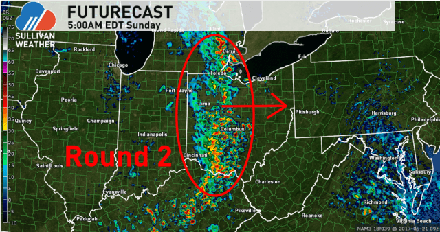
Sunday:

We may see a brief period of dry weather Sunday morning after the Saturday night round of showers/storms. This will not last long, as a cold front will move through from west to east between 12pm and 10pm Sunday. Lift from the front and jet stream are expected to cause another round of showers and storms to develop Sunday afternoon. We should dry out from west to east behind the front later Sunday afternoon and evening. How fast the front moves through will determine how much of a severe threat exists with the front; a slower front, such as the model above shows, would mean a severe threat potentially as far west as Cleveland and Columbus Sunday afternoon/evening, while some of our models have a faster front and keep the severe threat confined to near the Pennsylvania border and points east.
The upper level trough responsible for all this weather will be what we call “closed off,” which tends to mean things slow down, so the potential for severe weather as far west as central Ohio is non-zero on Sunday. I wouldn’t expect a big outbreak on Sunday, but winds aloft will be pretty strong so some storms may produce strong to locally damaging winds.

The Storm Prediction Center currently has just far eastern Ohio in a MARGINAL RISK (risk level 1/5) for Sunday afternoon and evening for severe weather. It is possible that this risk gets edged west a bit if our models come into agreement on the slower front, and an eventual upgrade to a slight risk (mainly for damaging winds) wouldn’t shock me.
Everyone should get into the low to mid 70s on Sunday…perhaps close to 80 in eastern Ohio if the front is on the slower side.
Heavy Rain:
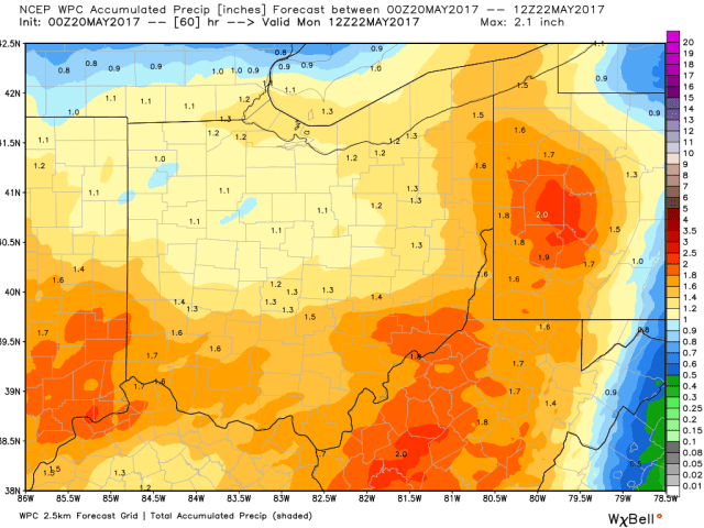
Widespread, area-wide average rain totals of around an inch to inch and a half are possible this weekend, on top of any rain that fell Thursday into Friday. On average, this won’t cause a ton of flooding, but locally heavier amounts are certainly likely where thunderstorms repeatedly track. This may result in local flash flooding concerns this weekend, and could cause a few creeks or rivers to come out of their banks where the heaviest rain amounts occurs.
We should get a dry period of weather Monday into Tuesday before wet and notably cooler weather moves in late Tuesday.
