

A line of rain showers (possibly mixed with graupel) will push off of Lake Erie into northeast OH/northwest PA early Thursday evening. Another batch of snow showers will likely push in later in the evening, possibly dropping some local light accumulations of less than one inch, especially in the higher terrain. Lake effect bands are expected to then develop later Thursday night into Friday morning…one possibly into the southern and southeastern side of the Cleveland metro, and another one into northwestern PA. The western band will likely weaken to just flurries and eventually disipate Friday morning after perhaps dropping some additional local light accumulations, while the eastern band slowly pushes west across the northeastern Ohio Snowbelt through the day Friday. The eastern band could drop a quick additional inch or two on parts of northwestern PA and extreme northeastern OH, especially in the higher terrain. This band could make it as far west as the Cleveland metro by Friday evening before disipating and may drop some additional very light accumulations, especially in the higher terrain south and east of town. Total amounts in the higher terrain in the heart of the Snowbelt will likely be 1-3″ with locally a bit more possible in PA. The lower elevations and locations farther west could see a light dusting up to as much as an inch. The higher terrain of the “secondary Snowbelt” could see locally an inch or so total if snow is persistent enough, but that’s not a given at this point. Travel impacts will be minimal, though with temperatures well below freezing some briefly slick travel will be possible when it’s snowing.
Technical Discussion:

A lobe of the polar vortex grazing the region will bring a brief shot of very cold air for the time of year, with 850mb temperatures falling to around -16C. Despite the extremely cold air in the low-levels, the trough only grazing Lake Erie and the high pressure building in quickly will cause lowering inversions, dry air, and a short fetch to limit the potential of this lake effect event.
After high temperatures pushing into the lower 50s Thursday afternoon, the strong cold front will cross early to mid-evening marked by a sharp wind shift and wind increase behind the front and quick drop in temperature. There will be good low-level lift along the front, though moisture will be lacking and the best chance for any precipitation will be downwind of Lake Erie.
Forecast soundings along the front show a fairly deep layer of good moisture and steep lapse rates up to around 8k feet at CLE, which along with good lift below about 7k feet should be enough to get a band of showers pushing in off the lake. Freezing levels are expected to initially be too high for snow, though moisture does get into the lower portion of the DGZ and the precipitation will be convective, so some graupel could mix in. The layer of instability is a little bit deeper farther up the lakeshore, so there may be a better chance of graupel farther up the shore.
Behind the immediate front there could be a lull in any shower activity for an hour or two, however a secondary surface trough along with some mid-level lift is expected to push onshore around 3z/10pm, likely bringing another chance at precipitation:

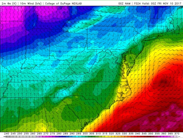
Between convergence along the trough as winds shift from WNW to more NW/NNW and frictional convergence along the shoreline, there will likely be enough focus for a line/band of precip to push southeast off the lake rather quickly late Thursday evening. The above model image is surface moisture convergence off of the NAM, and shows some enhanced convergence near the lakeshore coinciding with the trough passage (also note how some weaker convergence extends farther west along the trough, possibly bringing flurries outside of the lake effect areas).
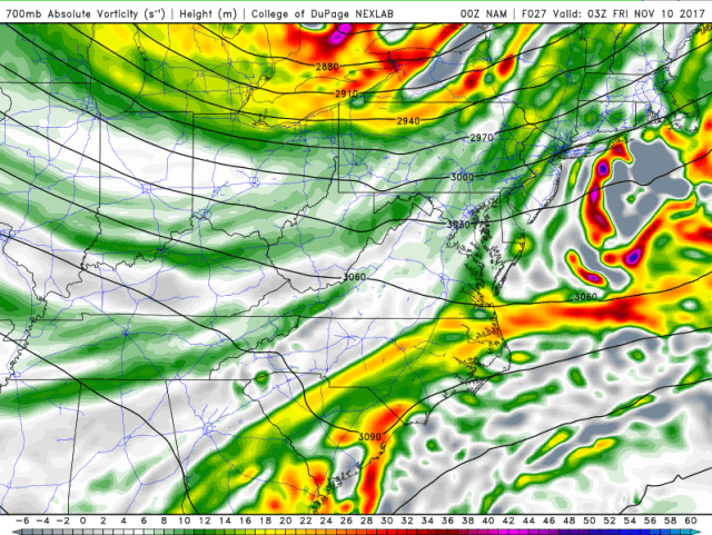
This secondary trough will likely be enhanced by a shot of mid-level vorticity grazing the region shortly behind the cold frontal passage. This PVA will also add some lift and enhance precipitation chances.
By the time this secondary trough pushes through, conditions will be a bit more favorable for lake effect. The winds are a little strong with some shear above 6k feet, which will likely limit any organization with the band of precip that pushes through, but there will still be a deep layer that is moist and very unstable. 850mb temperatures will quickly be falling to around -10C as this secondary trough pushes through which is cold enough for snow…though temperatures at the surface will likely still be near or a bit above freezing.
All in all, after an initial round of mainly rain showers with the initial front, a secondary round of snow showers (that may be briefly heavy) will likely move through the Cleveland metro and east side (as well as all the way through the Snowbelt and into NW PA). The disorganized nature of these snow showers and brief window will limit potential accums, but some areas could see a quick dusting (perhaps a half inch to local inch of there are any particularly heavy snow showers). There will then be a bit of a lull in the sinking motion behind this trough until some upstream lake connections can develop later Thursday night and into Friday morning.

There will be two potential upstream connections to watch for as the winds come around to the NNW later Friday night:
- A Lake Superior/Michigan connection that initially sets up on the east side after midnight and gradually settles towards the southern suburbs by Friday morning, and then likely dissipates as the high builds in on Friday.
- A Lake Huron connection that moves into NW PA late Thursday night and then gradually slides west (while slowly weakening) through the day Friday as the winds continue to come around to the N and even NNE by Friday evening.

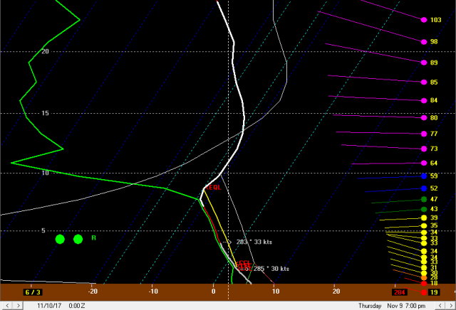
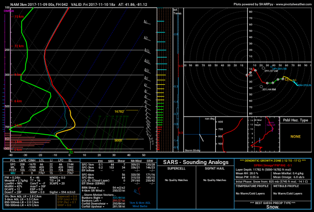
Above is a forecast sounding for CLE when the potential Superior/Michigan connection would be developing. There is a lot of dry air however, there is some moisture below the inversion along with very steep lapse rates. This combined with very little shear and somewhat weaker winds could allow for a loosely organized band to develop across parts of southern Cuyahoga, extreme NE Medina, northern Summit, and perhaps southwestern Geauga/northwestern Portage Counties for a few hours later Thursday night into Friday morning, before the possible band shifts farther west/likely dissipates later Friday morning. With the entire cloud layer in the DGZ and over 700 J/KG of lake induced CAPE in the sounding, any snow showers that develop could be heavy enough to accumulate…however, with a short fetch, dry airmass, and complete lack of any synoptic scale lift in the region, it’s hard to get excited. Could someone sneak out a local inch of snow, and maybe a larger area see some light dustings in the higher terrain just south and southeast of Cleveland out of this? Sure…but given the negatives and short duration I have a hard time seeing more than a local inch or so of snow panning out with this potential “band,” and even that I’m not completely confident in…it could just end up being flurries if the upstream connection isn’t strong enough to overcome the drier air.

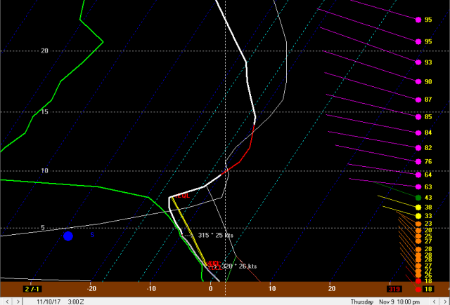
A sounding at KERI valid when the Lake Huron band is expected to begin moving gradually southwest across NW PA is more impressive, with a deeper layer of instability and moisture and manageable levels of shear. There is enough “juice” there for the Lake Huron band to produce moderate to heavy snow…however, the winds will still be shifting so it may not spend more than an hour or so in any given location in NW PA, with only light snow showers in the higher terrain outside of the band. If the band slows down somewhere, a narrow corridor could see a quick 2-4” of snow, but otherwise this is looking like a quick inch or two in the higher terrain of NW PA with just a coating closer to the lake shore. Given the potential timing Friday morning this could still interfere with the commute.
As the winds continue to gradually shift to a more northerly direction on Friday, the Lake Huron band will continue west into northeastern Ohio. The band will likely not spend an hour or two in any given spot, limiting potential accumulations. Forecast soundings from within the band still support moderate snow within it into Friday afternoon, with good moisture/steep lapse rates up to about 7k feet and good lift into the DGZ, along with only weak to moderate wind shear, so some quick accumulations can’t be ruled out, but in general amounts from the Huron band in Ohio will struggle to pass an inch or two.
The hi-res models insist on getting the Huron band into the Cleveland metro by late Friday afternoon/early evening, but drier air and lower inversions will continue to work in, making it questionable how intense it is when it gets in:

Lapse rates remain steep with enough moisture below 5k feet, to go along with some instability into the DGZ and little wind shear below the inversion, so there’s probably enough juice there for light and somewhat high ratio snow…however, with the band likely continuing to move and snow rates kept on the lighter side, I have a hard time seeing more than about half an inch of new accumulation in the higher terrain in southern and eastern Cuyahoga/northern Summit/northern Medina with perhaps a light dusting closer to the lake and a bit farther west before the band completely dissipates.
For total amounts, am generally thinking 2-3” total in the higher terrain in NW PA when combining the late Thursday evening snow showers and Huron band passage early Friday morning…a local 4” is possible if the Huron band slows down anywhere, but that’s not a given. In general am thinking 1-2” total in the higher terrain in northern Geauga and inland Ashtabula County when combining the Thursday evening snow showers and Huron band passage…I can’t rule out a local 3” amount if the Huron band slows down anywhere, but again, not a given. In the Cleveland I can see how someone in the hills south or southeast of town squeaks out an inch or inch and a half of total snow if both phases of the event pan out, but the lower elevations will likely see a dusting at best, and even in the higher terrain of the secondary Snowbelt it’s very possible an inch doesn’t even fall, as neither portion of the event looks like a given for that area.
