
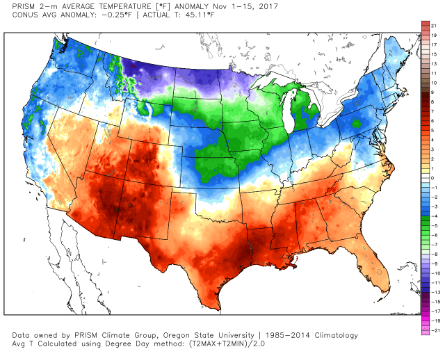
Month to date temperature anomalies through November 15th
A site for sore eyes…blue on a temperature anomaly map over the northeastern US so far in November. The coldest air, by far, has been centered the northern Rockies and Plains, but has leaked east frequently. As is often the case in a La Nina, much of the southern US has been warmer than normal so far this month.
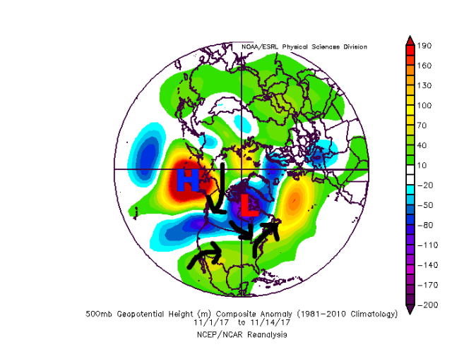
Upper-level height anomalies from November 1-14, 2017
This cold, as often is the case during a La Nina, has been driven by anomalous ridging over the North Pacific. This has directed significant cold into western and central North America. The NAO has actually been positive thus far this month, allowing for a weak SE ridge on the 500mb mean, however, the dense low-level cold has seeped into the northeast more often than not, causing negative surface temperature departures despite weak positive upper-level height departures.
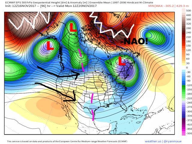
European ensemble forecast upper-level pattern valid Monday 11/20
Things are changing though as we head into Thanksgiving week; a strong storm this weekend will cause a rather transient trough to move through the Great Lakes and Northeast, bringing a re-enforcing shot of below normal temperatures and some modest snow, especially downwind of the Great Lakes. This strong storm will help pump up ridging over Greenland and the Davis Strait, causing a –NAO to develop. Unfortunately, a strongly –PNA will cause a zonal flow of Pacific air into the western US, which will cause this initial trough to skedaddle fairly quickly, limiting how much snow potential there is Sunday into Monday behind the storm.
With that said, another shortwave in the northern stream (over Alberta and Saskatchewan in the above image) coming in behind the northeast US trough and developing –NAO may have some more luck in buckling the flow over the US during Thanksgiving week as the –NAO becomes classic looking.
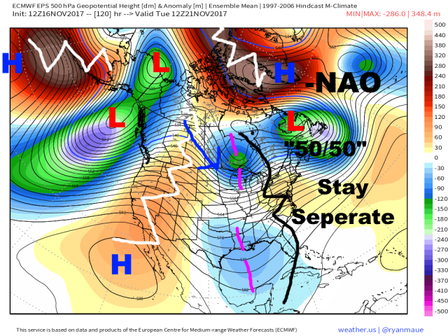
European ensemble forecast upper-level pattern valid Tuesday 11/21
By Tuesday, the ingredients appear to be in place for the next shortwave to amplify and carve out a trough over the Northeast. The –NAO is a classic one, with a closed off ridge over Greenland and the Davis Strait. The weekend’s trough is centered near 50N, 50W, acting as a “50/50 low” and further encouraging the next shortwave in line to dig farther south and slow down. Some people seem to be dismissing the influence this –NAO will have or questioning if it’s legit…it’s legit, and will impact the pattern for much of the second half of November. A closed off ridge over Greenland and the Davis Strait with a 50/50 low south of it is a classic block with “traffic” over the North Atlantic to slow incoming troughs down. The issue at the moment is getting the Pacific to cooperate with the very favorable looking Atlantic side pattern.
There is a piece of energy in the sub-tropical jet over the Gulf of Mexico, but the fast Pacific flow in place into early next week is expected to prevent any phasing between the polar jet and sub-tropical jet shortwaves, precluding a big storm risk over the eastern US. With that said, ridging is expected to amplify some over the western US early next week, allowing the northern shortwave to tap some solidly cold air. Although there isn’t a big cross-polar flow in place, the air over western Canada that the northern shortwave will be tapping will be colder than normal for that region:
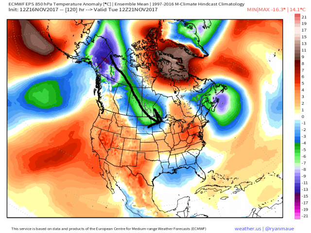
European ensemble 850mb temperature departure forecast valid Tuesday 11/21
Given the –NAO and 50/50 low over the Atlantic this cold air should build into the Northeast US on Wednesday and Thursday. Due to the lack of sub-tropical jet involvement and how far north the shortwave is, a big storm is very unlikely in the east. The bigger story will be a re-enforcing shot of colder air and perhaps some light snow from a clipper, and also another shot of lake effect snow in the Great Lakes.
The GFS and European suites disagree on exactly how much this trough amplifies over the Northeast…here’s the European:
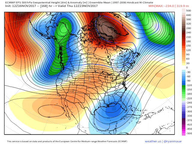
European ensemble forecast upper-level weather pattern valid Thursday 11/23
The GFS ensembles dig the trough much more (and the Euro ensembles, while flatter, have trended more amplified in general with the pattern), which in my opinion seems like a more likely outcome (rare to favor the GEFS over the EPS anymore it seems):

GFS ensemble forecast upper-level weather pattern valid Thursday 11/23
The reason I’m favoring the GFS is due to the ingredients in place ahead of the shortwave over the Atlantic (-NAO, 50/50), brief ridge amplification over the west, and cold air to be tapped behind the shortwave. This all to me suggests a more impressive shot of cold and deeper trough than the Euro suite indicates over the Northeast Wednesday-Friday of next week. There won’t be much if any snow outside of lake effect Snowbelts and perhaps NW flow upslope areas in northern New England, but the idea of a pretty cold Thanksgiving seems likely in much of the eastern US.
As we head towards the end of November and into early December, there are signs of a warm-up, but I would be slow to forecast temperatures rising to above normal over the east. It’s also questionable how long any warm-up lasts into December.

European ensemble forecast upper-level pattern valid 11/26
By day 10, the ensembles both generally agree on a west-based –NAO persisting along with a modest +PNA (lower heights near the Aleutians, higher heights over the western US). The European ensembles completely change the north Pacific pattern by this point, with a large area of negative height anomalies over the north Pacific, with the strongest anomalies over northeast Asia and the northwest Pacific. This look risks flooding North America with milder Pacific air, but with the +PNA and –NAO still in place at this point, the eastern US would likely remain on the cold side. There’s actually a modest storm signal on that image with a neutrally tilted trough over the Ohio Valley and –NAO/+PNA in place, though with no 50/50 low on the EPS we’d likely see any storm track a bit too far NW for snow outside of the higher terrain and locations well inland.

GFS ensemble forecast upper-level pattern valid 11/26
The GFS ensembles valid at the same time have some similarities and some differences to the European suite. The GFS ensemble also develops a large negative height anomaly over NE Asia and the NW Pacific, but is slower to lower heights near Alaska. The GFS ensemble keeps the –NAO in place and in fact has a more classic look, with the block over Greenland and the Davis Strait (with somewhat stronger positive height anomalies), and also hints of a 50/50 low (from the previously discussed Wednesday-Friday NE US trough). The GFS ensembles also have hints of a modest +PNA and a trough moving into the east, also suggesting some potential for wintry mischief in the Northeast.
The differences between the suites between the Euro (less favorable for a potential NE US snow event) and GFS (potentially favorable for some sort of snow event) appear to lie in how they handle the Thanksgiving NE US trough and –NAO. The GFS suite digs the trough more due to the –NAO, which in turn helps pump up the heights near Greenland and causes the trough to move slower, allowing it to be in place as a 50/50 low ahead of the next trough. The ECM is more progressive with the trough and hence allows heights to rise over the Northeast ahead of the November 26-28th trough, keeping any risk for snow much farther northwest.
Given the classic nature of the NAO block and potential western US ridge amplification next week, I’m inclined to think the GFS suite may be on to something here. Given this, the potential may be there for a light to moderate winter storm mainly in the interior northern Mid Atlantic and New England between November 26-28th. The best threat for snow near the coast will be from NYC north, farther south the pattern may still not be amplified enough to force the northern stream shortwave far enough south to get a low with sufficient cold to develop fast enough. There could also be a risk for modest snow in the Great Lakes/northern Ohio Valley as the shortwave/potential clipper moves through, along with lake effect in the Great Lakes.
It’s early in the season yet for big I-95 snowstorms and there are some flaws to the pattern (less than perfect Pacific), so expectations shouldn’t be too crazy, but areas such as northern PA, Upstate NY, far northern NJ, possibly NYC or its suburbs, and New England could be in line for a corridor of half decent snow around November 26-28th. Confidence is low to medium right now due to distance in time, conflicting signals, and some flaws in the pattern.

European ensemble forecast upper-level pattern valid 12/1
By early December, the European ensembles are at an interesting juncture; they maintain the low heights over the northern Pacific and gradually weaken the –NAO, but still have enough of a northwest flow over eastern North America to maintain a trough over the East Coast and keep temperatures near or somewhat below normal.

GFS ensemble forecast upper-level pattern valid 12/1
The GFS ensembles do have some similarities and differences. The GFS ensembles also maintain some higher heights over NE Canada and a eastern US trough (remains of the –NAO), and have a trough off the West Coast along with modest ridging over western N. America.
Both sets of guidance have a much warmer look for North America as a whole than what we’re seeing now, but both ensembles show a pattern that is close to turning very cold over the eastern US. Shift the negative anomaly over the northern Pacific a bit farther south or west on the Euro ensemble or a bit west on the GFS ensemble and you pop a +PNA, likely get ridging up into Alaska and towards the pole, and likely get a deepening trough on the East Coast which helps cause the NAO to fall again. So that’s an interesting thought heading into December. On the other hand, if that negative anomaly is a bit farther north or east, we see a near continent-wide blow torch pattern. Playing with fire, eh? It’s also interesting to note that storminess in the Bering Sea can help perturb the stratospheric polar vortex, possibly increasing the risk for more high latitude blocking well down the road if this comes to pass.
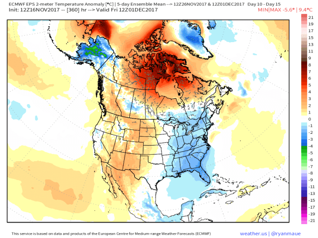
European ensemble forecast surface temperature departure from November 26-December 1
Regardless, neither ensemble mean currently has above normal temperatures over the east for the last few days of November (though there’s a lot of variability among the individual members). The GFS ensemble mean is actually a few degrees F cooler than this…given the –NAO, somewhat more favorable western US ridge, and potential for a few shortwaves to deepen that trough between this weekend and the last few days of November, the risk for a colder solution as the GFS ensemble shows is certainly elevated…and even the EPS solution isn’t warm over the east through the rest of November.
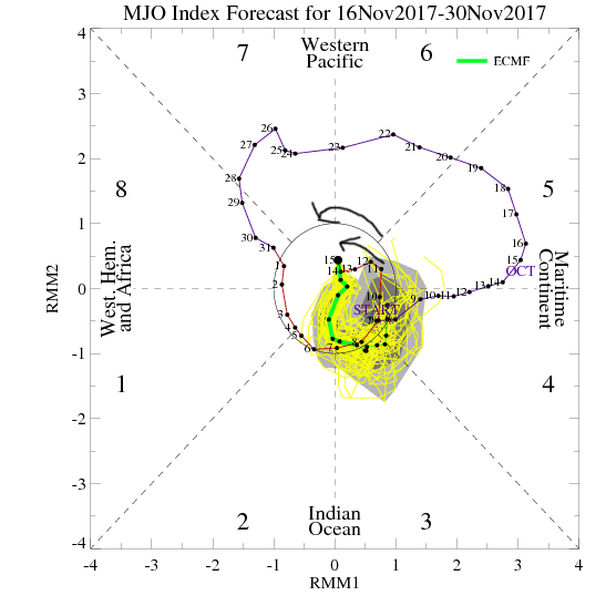
European ensemble MJO forecast for the next two weeks
When trying to figure out if the pattern will turn back to very cold by the second week of December or turn catastrophically warm, are there any clues? The Euro ensembles, which have done a much better job with the MJO lately than the GFS suite, have some members getting weakly into phases 3/4/5 late in November, with a few heading towards phases 6 & 7 in early November. Many other members stay just inside the circle, where the MJO isn’t strong enough to really influence the pattern.

Temperature correlation in November-January to the MJO phases
Phases 3-6 of the MJO are typically mild in the central and eastern US, though it appears the –NAO and briefly more favorable western US ridging to go along with the weak nature of the MJO will stave that off through the end of November. As the –NAO weakens, it’s possible we see a warm-up early in December. From there though, it appears the MJO either heads into the indeterminate circle or towards colder phases, possibly supporting colder conditions returning.

GFS ensemble global atmospheric angular momentum forecast
The above plot shows the forecast global atmospheric angular momentum and forecast for the next two weeks from the GFS ensemble. In general, higher AAM means a stronger polar jet stream and more zonal flow, while a lower AAM means a much more buckled jet stream. The GFS ensembles have been persistently predicting a very low AAM late in November and through the end of the run to start December, which would suggest the potential for increased high-latitude blocking and a very meridional (north-south oriented as opposed to west-east) jet stream in the mid-latitudes.
All in all, there are some interesting signs to start December. I think a warm up is possible due to the Pacific “re-arrangement” that appears likely to end November and start December, but signs point towards a potentially cold and stormy pattern over the central and eastern US developing perhaps as soon as just a few days into December. It’s also possible the warm-up is muted if my concerns about the EPS being too progressive in the face of the –NAO end up being correct. On the other hand, the pattern near the turn of the month may briefly turn quite warm across the continent if the shorter term –NAO fails and the Pacific jet is allowed to run rampant…you’ll want to stay tuned as we keep heading towards December, as cold risks appear to be increasing but we can’t be 100% confident yet.
