
This is a pretty interesting/tough forecast for the remainder of this LES event through Wednesday night…
Indications are the band (which the heart of is actually north of Erie at the moment) will reach its farther north point by 7-8pm, and then begin sinking back south as a weak surface trough evident over SE MI pushes east this evening and causes winds over the lake to shift from SW to more west. This should allow convergence to increase from near Euclid up the shoreline and allow decent snow to develop up the shoreline in NE Ohio by mid to late evening. As winds on the lake continue to gradually veer to more WNW after midnight, the snow will likely push inland into more of NE Cuyahoga and northern Geauga County. Given WNW to almost NW winds over the lake I have to imagine it will push inland over Erie County as well.
The band will likely stall or really slow down for several hours after midnight or 1am, especially across the eastern Cleveland metro. This is due to the winds on the lake not moving much, possibly in response to the mid-level shortwave approaching/moving overhead, and due to the shape of the shoreline near Cleveland likely focusing shoreline convergence in that area for several hours. The hi-res models have a known bias (that has been on display constantly this event) to underdo shoreline convergence and push bands inland too quickly. Given where the models place the band, the expected wind direction, and shape of the shoreline, my guess is it will lay near the western lakeshore (perhaps nipping land at times very close to the lake west of Cleveland) and then move inland near or just slightly NE of downtown and then push ESE through the eastern suburbs towards Chesterland and South Russel. The NAM and RAP both have a crosshair signature for several hours late tonight (strong lift in the DGZ and decent RH in the upper half or so of the DGZ), which along with moderate lake-induced instability and EL heights of 9-10k feet suggests the band will produce heavy snow with rates of 1-2″ per hour. Given it may move little for several hours, the potential for several inches of snow exists in the eastern suburbs into northwestern or west-central Geauga County. With some large scale lift from the shortwave passage think the higher terrain in the rest of the northern Snowbelt will hang on to snow showers in this time, but nothing too organized or heavy. If this band pans out could see some spots get near 8″ by morning under the band in the eastern suburbs.
The shortwave finally passes Wednesday morning, resulting in some sinking motion and winds veering even more to NW over the lake. As temps on land warm the lake-aggregate trough and shoreline convergence should weaken, causing the band to swing southwest and become less organized. The band will likely lose its lake Michigan connection Wednesday afternoon. Even so, moderate to borderline extreme instability may result in snow showers continuing from Lorain County points east, likely heaviest a bit inland given no dominant band or shoreline convergence. These may result in additional light accumulations late Wednesday morning through the afternoon. The combination of a cold and somewhat drier airmass may limit snow growth late Wednesday morning and beyond, possibly limiting ratios with any snow showers that persist, so I suspect amounts after about 10am Wednesday through the rest of the day will be reasonably under control.
I still don’t trust Wednesday night not to produce some additional accumulations. With winds going NW to even NNW a Lake Huron band may set up over NW PA and produce a couple inches or so. As temps drop on land convergence will increase along the rest of the shoreline. With winds going very light after midnight, some “tea kettle” snow may result with convergence near the shore just spilling inland, possibly dropping accumulating snow near the shore. This could occur as far west as Lorain County. The light winds and extreme temp differential between land and water may support meso-low formation too, which could also brush the shore with some accumulating snow. Any lingering snow should end Thursday morning.
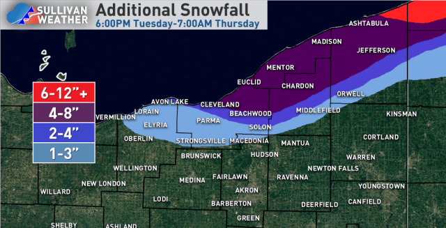
For additional accums, given the band gradually progressing south tonight think a general 4″+ is doable over most of the northern Snowbelt. I kept amounts at 4-8″ over the eastern suburbs into western Geauga County, though I can’t rule out a higher amount if the band after midnight into early Wednesday remains stationary enough. A few mile bust in band location results in a lot of population seeing different amounts, so that’s a sensitive forecast which also factored into my decision not to pin down a 6-12″ area. Think the period of snow along the shore tonight along with the potential for tea kettle lake effect Wednesday night supports 4″+ additional snow even along the coast. With the band currently affecting extreme NE Ashtabula County and coastal Erie County, along with a potential for a Huron connection early tomorrow night and tea kettle snow after midnight that 6-12″ (locally more) is doable in those areas. The inland penetration of snow in NW PA is tough, but think once the band swings south later tonight with a quick accumulation that enough opportunities for snow showers (especially if some Huron moisture is involved) exists for at least a few to several inches of total additional accumulation in inland Erie County possibly clipping northern Crawford County.
