
Here’s my first guess on the LES…I’m trying to sneak in a nap before the Cavs play so this write-up will be a little more curt than normal with no images.
Winds will turn around to a more due westerly direction over the lake this evening behind a weak mid-level shortwave, which should allow convergence to move back south to northeastern Lake County and northern Ashtabula County and re-intensify over northern Erie County as we head into tonight. This is expected to allow the lake effect snow band to push back onto land near the lake in this area. Convergence will be strong near the shoreline with moderate lake-induced instability to go along with ample moisture below about 6-7k feet and EL heights of 8-10k feet (lower at CLE higher at ERI). BUFKIT shows lift focused in the DGZ along with high RH through most of the DGZ promoting high ratios, which along with the convergence and decent but not outstanding instability should allow for 1-2″ per hour snow rates thanks to the ratios in the band. Some pre-seeding from Lake Michigan is also expected to develop tonight, which along with weakening winds maximizing residence time and a long fetch should allow the band to take full advantage of the fairly good parameters in place. The band may move little from this evening into the overnight, and may produce 6-10″ of snow in a few or several hour period of time where it affects. The most likely area to see this will be extreme eastern Lake County, northern Ashtabula County, and the northern half or so of Erie County, PA.
All models show the winds coming around to a solid WNW direction over the lake late tonight through Tuesday morning, which should push the convergence and band a little farther south. Winds inland will remain WSW, and a strong temperature difference between over water and inland should result in a strong lake-aggregate trough, which along with the WNW winds not being terribly strong argue against the band pushing very far inland. The hi-res models do try to push the band as far south as Downtown and NE Cuyahoga/central Geagua/southern Ashtabula County. Given the aforementioned factors and known bias for models to place LES bands a little too far south, my guess is we’ll see the band get to extreme NE Cuyahoga County (Euclid/Mayfield area) but not quite to Downtown and then points east into Lake County and Geauga County mainly near and north of route 6. It may briefly get as far south as close to 322, but I’d hedge on heavier amounts being closer to 6. With a solid WNW push of winds, the band will probably push south of the Ashtabula County and Erie County lakeshore for several hours late tonight into Tuesday morning. Parameters remain similar to those described above, which should allow rates of 1-2″ per hour to continue under the heart of the band. Winds may move slowly enough for a the band to be relatively stationary for a few hours, possibly allowing another 4-8″ of snow to fall under the band late tonight through noon Tuesday. The area most likely to see this will be Lake County, northern Geauga County, Ashtabula County just inland from the lake, and perhaps far northeast Cuyahoga County.
Tuesday afternoon the winds will back to the west/southwest over the lake ahead of a more robust shortwave, likely causing snow to lift north and potentially reorganize for a few hours over northeastern Ashtabula County into Erie County, possibly dropping another corridor of several inches of snow fairly quickly. Behind that wave Tuesday evening through Wednesday the winds will gradually veer and instability/moisture depth will improve. Winds inland will remain WSW and a strong temperature differential will remain between the lake and land, likely maintaining strong convergence near the shore. This will push the band back down the shore and gradually a bit farther inland Tuesday night into Wednesday. It may affect the northern Snowbelt (extreme NE Cuyahoga, Lake, northern Geauga, northern/central Ashtabula, parts of Erie County likely a bit inland) for a few hours later Tuesday evening as the winds on some models get hung up a bit ahead of another little 700mb vort max. EL heights of near or better than 10k feet (higher on the ERI soundings) and good moisture to 7k feet, a long fetch with relatively weak winds/little shear on soundings over the lake, moisture from Lake Michigan, along with a saturated DGZ and strong lift centered in the DGZ in the band on both the GFS and NAM suggest the band could produce very efficient and heavy snow, with rates of 2 to perhaps 4″ per hour likely Tuesday evening. If it slows/stalls for a few hours over the northern Snowbelt, that corridor would see an additional 6″+ quickly and possibly up to a foot in short order.
The band should resume its southward drift around midnight or so behind the vort max and should get into much more of Cuyahoga County. This will be an interesting setup for Cuyahoga County late Tuesday night through a good chunk of Wednesday. Models show winds of 285-295 degress with a clear trough axis near the county, with CLE BUFKIT soundings maintaining extreme instability, EL heights of near 10k feet, moisture in the lowest 5k feet at least (higher through mid-morning Wednesday), and lift centered in the DGZ. A Lake Michigan connection should maintain through most of Wednesday and winds will be fairly light/well aligned, maximizing residence time and it won’t be a short fetch. There is enough juice for a warning criteria snowfall over much of northern/eastern Cuyahoga County including in or near Cleveland into central/southern Geauga County late Tuesday night and through Wednesday, with more disorganized snow showers focused mainly in the higher terrain in the rest of the Snowbelt during the day as the convergence should be well south by that point. This band could also affect far northeastern Lorain County at times. Still some time to evaluate the potential in Cuyahoga County, but a number of ingredients still appear to be in place. One potential negative will be temps getting cold enough Wednesday afternoon and low-level dew points dropping enough to start drying out the DGZ. This could cause snow ratios to diminish Wednesday afternoon, though right now indications are ratios should remain pretty high through Wednesday morning, especially in any organized bands where latent heat release would likely push the DGZ up into the clouds.
The lake effect will really diminish Wednesday night, however, some additional accumulations aren’t impossible. EL heights will remain 5-7k feet with some moisture beneath the inversion and steep lapse rates. Winds will be very light and veer onshore. The light winds and strong low-level instability may favor meso-low development or at least some “tea kettle” lake effect that grazes the shore. This could produce locally another couple inches or so Wednesday night mainly near the lake.
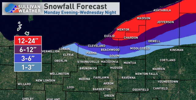
For total accumulations, think there’s more than enough opportunity for heavy snow to go with 1-2′ in the northern Primary Snowbelt. The bands will be moving off and on which may limit the max potential in OH (and even in PA for additional snow starting this evening) to around 2 feet. Kept the southern cutoff a bit north of what many models have, however, if factors continue to point to a decent period of LES in Cuyahoga/southern Geauga Counties later Tuesday night into Wednesday night amounts will need to be bumped up in those areas. I fully think LES warnings will be needed for Lake and Geauga Counties. Cuyahoga County will eventually need at least an advisory, with potential for localized warning amounts late tonight into Tuesday morning in the extreme NE corner of the county as well as for more widespread warning amounts Tuesday through Wednesday evening.
