
Take home messages:
- Despite brief cooldowns behind storms, much of the eastern US will be mild overall through the end of January.
- Cold will dive into the central US by the beginning of February, and likely work into the east more consistently during the second week of the month.
- Signs point towards potential significant cold, perhaps as cold as or colder than what we experienced in early January in some areas.
- Cold, potentially significant at times, may last for much of the rest of February in the eastern and central US.
- A winter storm will be possible across the northern Ohio Valley, southern/eastern Great Lakes, and perhaps interior New England during the first few days of February.
- The pattern may become more supportive for snows, perhaps decent, across more of the east around February 10-15, but some flaws will likely remain in the pattern.
Discussion:
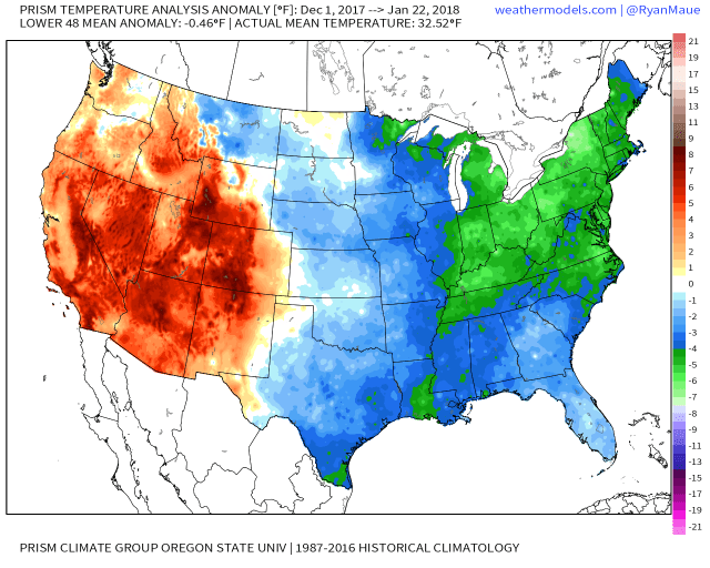
Temperature departures from normal from December 1-January 22nd, meteorological winter so far
It has been a pretty cold start to winter across the eastern half or so of the country, with significant chunks of the Ohio Valley, Great Lakes, Northeast, and Mid Atlantic running at least a few degrees colder than normal so far for the winter. A large chunk of this is due to a significant and in some areas record breaking cold snap to start the year. The current weather pattern has brought some much milder conditions to most of the central and eastern US, a welcome January thaw for many people:
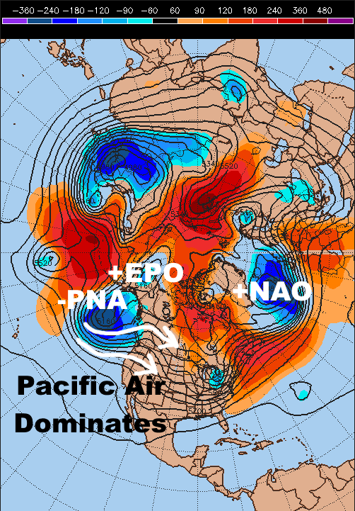
Current upper-level weather pattern over the Northern Hemisphere
The current pattern does not support much cold over the central or eastern United States, with a +NAO (trough over Greenland/the north Atlantic), -PNA (ridge over the Aleutian Islands and trough near the West Coast), and +EPO (upper low over Alaska) limiting the ability for cold air to move into central and eastern portions of the country. Instead, Pacific air is dominating, with periods of warm weather broken up by a couple of days of near normal conditions behind any storms moving through. This pattern will continue for the rest of January…but a change is in the works pretty soon.
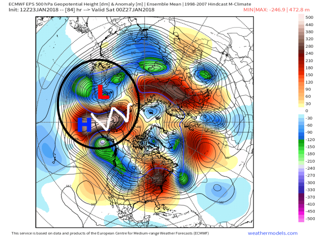
European ensemble forecast upper-level pattern valid Friday evening
The first step of many of this change back to a colder pattern will begin over the next few days over the northern Pacific. A strong storm over eastern Russia will cause a large anti-cyclonic wave break over the north-central Pacific between Alaska and Russia, forcing a very amplified ridge in the jet stream to develop over the Bering Sea. This ridge will break off into a robust blocking ridge and move towards the Pole into next week:

European ensemble forecast upper-level pattern valid evening of Tuesday, January 30th
This blocking ridge will facilitate a prolonged “cross polar flow” into northern Canada, causing a deep reservoir of cold air over Siberia to be tapped and transported into North America. Siberia is much larger and sees much less marine influence, and therefor tends to be much colder than northern Canada during winter. This tap of very cold air will cause Canada to become quite cold over the next week or so, with that air ready to drop into the US once the pattern allows:
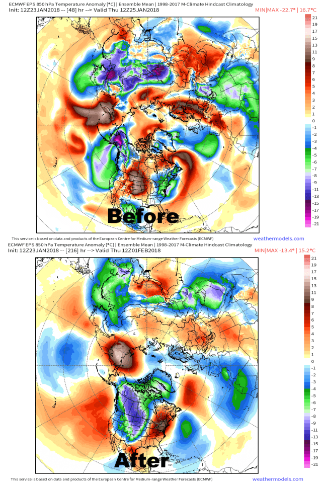
European ensemble forecast temperature departures from normal valid this Thursday morning and next Thursday morning
Before the blocking ridge and cross polar flow develop, Asia features a much larger pool of cold air than North America. By later next week, a substantial amount of cold has spilled into Canada and is poised to move into the US…the question is, when will it actually get here?
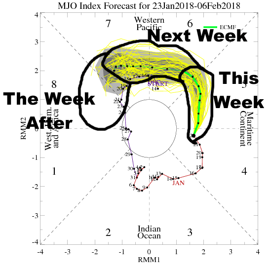
Madden Julian Oscillation or MJO forecast for the next two weeks
The MJO is a coupling of the atmospheric circulation and thunderstorms in the tropics. Where the enhanced thunderstorms occur has a significant impact on the large-scale weather pattern across the globe, particularly during winter, as the storms give off large amounts of heat into the upper-levels of the atmosphere and modulate where the jet stream is and how strong it is. There are well-known correlations between each MJO phase and temperatures across the US:

Temperature composites for January-February-March for the various MJO phases
We are well into the “warm” phases now, and will be through this week and into next week. There will be brief cooldowns behind any storms that go by, but overall the temperatures will average out warm over about the next 10 days over much of the central and eastern US. This matches well with the MJO progression. Later next week the MJO heads into phase 7, which while typically not cold in the east is not quite as warm, with the implication being the MJO will continue to work into phase 8 and potentially 1 thereafter, both cold phases. By MJO progression, we can expect a turn to much colder conditions in the central and eastern US by the second week of February. However, it appears that some big cold will arrive a bit earlier, particularly in the central US…

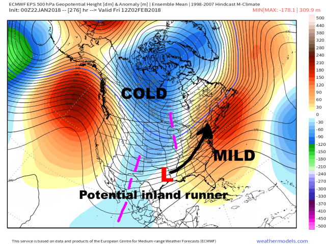
European ensemble forecast upper-level weather pattern valid Friday, February 2nd
The previously discussed ridge over the north-central Pacific that closes off and moves towards the polar region is expected to pin an upper-level low/trough to its south over the Aleutian Islands later next week, a configuration known as a rex block. Because both features are expected to be “closed off,” the pattern may be fairly stable for at least a few days. This trough over the central Pacific is expected to help build up a ridge in the jet stream near the West Coast, causing the PNA to become positive and allowing the frigid air building over Canada to plunge south towards the northern Rockies, Plains, and Midwest by the end of next week.
This initial pattern still isn’t particularly cold for the eastern US due to some lingering SE ridge (encouraged by the MJO progression) and the ridge being centered a bit off the West Coast, so the cold may not plow all the way to the East Coast consistently during the first week of February…but the central part of the country should turn quite cold right around the turn of the month.

European ensemble mean upper-level pattern valid February 2nd-February 7th
The ridging over the eastern Pacific towards Alaska is expected to be very persistent into February for a couple of reasons. The first reason is the persistent vortex from NE Asia to the Aleutians, a feature that’s been common this winter so far, is not going to be displaced anytime soon and will continue to pump up that ridge. Also, the MJO progressing east towards phase 8 in two weeks and possibly phase 1 in about 3 weeks supports a +PNA (ridge along the West Coast). Not only does the pattern moving forward seem to support what the models are showing, but the pattern so far this winter looks awfully similar to what’s projected coming up:
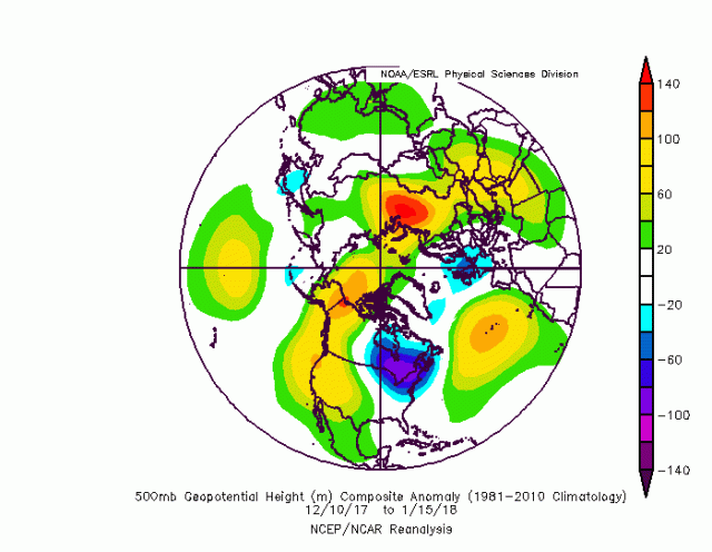
Mean upper-level pattern valid 12/10/17 to 1/15/18
Above is the upper-level pattern that dominated from the second week of December through early January, a rather cold period over much of the central and eastern US. The pattern this winter has already featured a big ridge on the West Coast and frigid air dumping into the central and eastern US, and nothing big has changed large-scale since then. As the factors begin to come into alignment over the next couple of weeks, a similar pattern will return. Given the expected MJO pattern, and the fact that this has been a persistent pattern for much of the winter so far, signs point towards the pattern lasting for a while too.
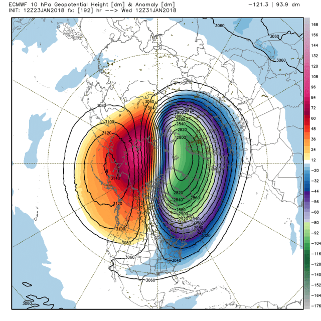
European model projected stratospheric weather pattern valid January 31st
In addition to the above mentioned factors favoring cold delivery into the US as we head into February, the weather pattern in the northern Pacific (low near the Aleutians and ridge to the north) favors an upward transfer of energy into the stratosphere, disrupting the stratospheric polar vortex. During the winter months in the northern hemisphere, the troposphere and stratosphere can occasionally interact. If the stratospheric polar vortex is strong and compact near the pole, it tends to correlate to a stronger and farther north jet stream in the troposphere, generally resulting in milder weather in the mid-latitudes. When the stratospheric vortex is disrupted, the opposite can occur.
The above image shows a displaced stratospheric vortex, but it’s not a true “sudden stratospheric warming” (SSW) event or vortex split, so may not have a strong contribution towards added “blockiness” in the tropospheric pattern. However, with a similar pattern potentially maintaining in the northern Pacific for some time, additional weakening of the stratospheric polar vortex could occur in early February, possibly adding an additional variable supporting high-latitude blocking in a pattern already supportive of big cold getting dislodged towards the US. Stratospheric warmings are hard to predict and have a high false-alarm rate on medium range modelling, so I’m not giving this idea a ton of weight right now, but the potential certainly doesn’t hurt the idea of big cold during February.
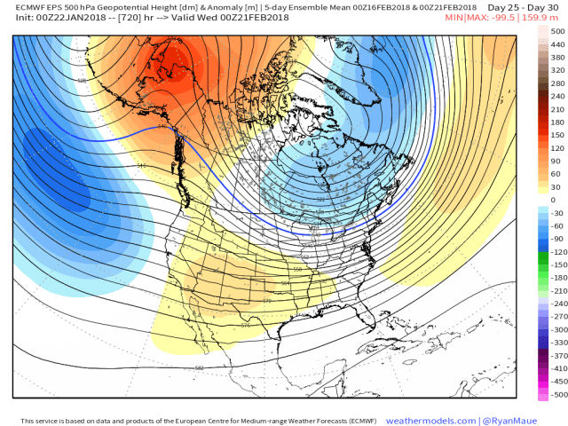
For what little they’re worth, extended range models through February insist on a similar pattern maintaining for the entire month:
European weeklies projections:
February 6-10:

February 11-15:

February 16-20:
February 21-25:

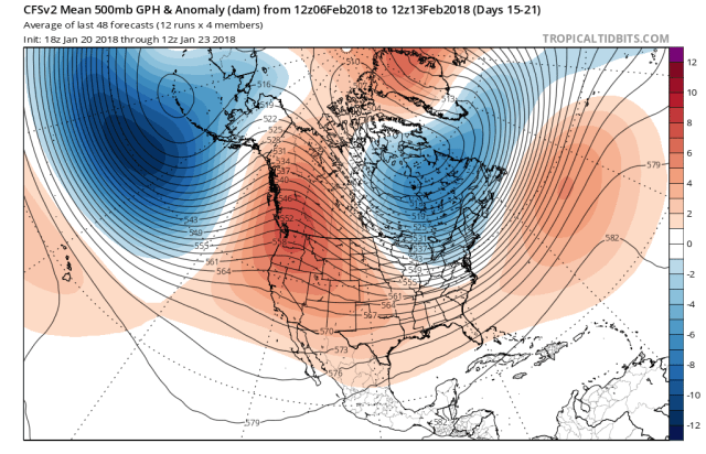
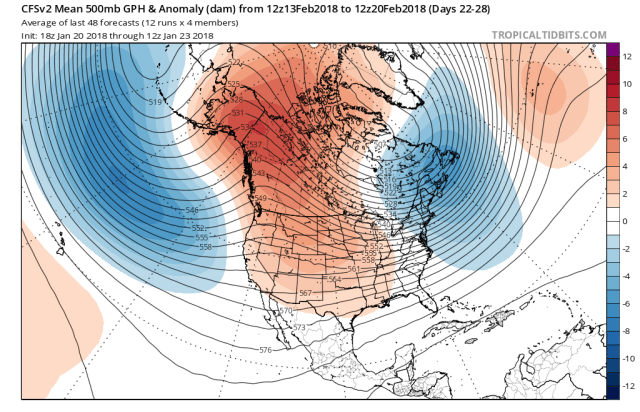
Climate Forecast System (CFS) projections:
February 6-13:
February 13-20:
February 20-27:

These models should be taken with an extreme grain of salt beyond about 3 weeks out, but, the pattern going into the week 3 forecast supports what the models show (cold beginning to spill farther east), with some hints that the pattern may be persistent. Both models persistently show the Alaskan ridging that’s dominated winter so far, and will return by the beginning of February, persisting through the month and driving a cold pattern over the central and eastern US. It’s in the realm of “believable”, and both models even show a re-intensifying of the blocking around February 20th or so, which is interesting agreement for so far into the future.
IN ADDITION to the modeling and shorter term forecast techniques, longer range techniques that don’t rely on the models and instead rely on past weather patterns so far this winter and up to the present also show cold lingering through much of February…
The Recurring Rosby Wave Train technique or RRWT analyzes large scale patterns that have occurred so far this winter and attempts to create a forecast going forward based on the idea that the patterns will repeat over the course of the season…and shows big cold for the second half of February (after a somewhat milder than what will occur first half):

The first image is valid February 13-17, middle image February 18-22, and third image February 23-27. I am skeptical of the first timeframe being that mild given everything discussed above, but the technique really unloads the cold after the 18th, strangely in agreement with the CFS and European weekly forecasts for later in February.
All of the above-mentioned ideas (extended range modelling and creating long-range forecasts based on a weather pattern that’s already occurred) both have their downfalls…but given the agreement between those ideas, and the shorter term evolution really supporting some big cold during the first half of February (perhaps focused on the Midwest initially and then spreading east the second week of the month), everything really appears to be coming together for a cold February in the central and eastern US. It is quite possible temperatures at times rival or are colder than the cold air we saw in late December and early January…and right now it looks like it may not really warm up back to near normal during the latter portions of the month. This has the potential to bring more record setting cold in February to parts of the central and eastern US…though it remains to be seen where exactly the coldest air sets up over the course of the month.
As for snow chances, I’m eyeballing a potential storm across the northern Ohio Valley, southern/eastern Great Lakes, and potentially interior New England during the first week of February as big cold dives into the central US but buts up against some lingering warmth in the east:
European ensemble upper-level pattern valid February 2nd
That timeframe during the first few days of February may feature some sub-tropical jet energy trying to eject east ahead of the incoming cold, which could spin up a storm for the interior.
Thereafter, the pattern may become somewhat more conducive for snow farther south and east:

European weekly upper-level pattern valid February 11-15
If the cold air swings east during the second week of February as the MJO progression and models suggest, it could increase snow risks in the eastern US should there be any storms to work with. There are some signs that energy could slip under the western US ridge and provide some sub-tropical jet shortwaves to work with (also supported by a potential phase 8 or 1 MJO). A +NAO will hurt big snowstorm chances in the east, but some players appear to be on the field.
Beyond mid-February, it’s much too early to time exact details in terms of cold and snow potential, but if it stays cold as looks likely some more snow chances will likely follow. Anyways, a lot to watch for over the next few weeks.
