
TAKE HOME MESSAGES:
- All of Ohio is vulnerable to heavy rain and flooding through this weekend due to the recent wet weather
- The heaviest rain recently, and coming up, will likely be across parts of central and southern Ohio
- Widespread and significant flooding is expected across parts of central and southern Ohio this weekend
- At least minor issues are expected farther north in the state
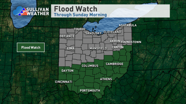
A FLOOD WATCH has been issued for all of southern and parts of central Ohio through the first half of this weekend. In the watch area flooding, that may be widespread and significant, is expected. North of the watch area, at least minor issues are possible. This flood threat is a culmination of a recent wet weather pattern that’s already produced some flooding and additional heavy rain falling this weekend on already saturated grounds and already high streams and rivers.
WHAT WE’VE ALREADY SEEN:
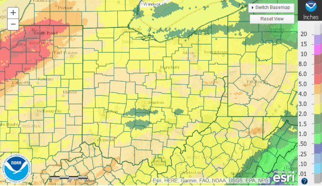
Observed rainfall between 7am on Thursday, February 15th and 7am Thursday, February 22nd
Essentially all of Ohio has seen over two inches of rain over the last week, with some portions of extreme southern and extreme eastern Ohio seeing over four inches. Note that some additional rain fell this morning after the cutoff, so some areas have actually seen a little more than this map shows. This rain has saturated the ground across all of Ohio and already caused its own flooding, with some river flooding across all portions of the state at some point over the last week. Particularly hard hit have been parts of east-central, southeastern, and southern Ohio, where there have already been two separate widespread flooding episodes and where the Ohio River has already seen a crest in the “moderate flood stage” range at many river gauges. Rivers in Northwest Ohio also are currently seeing flooding as the very heavy rain over northern Indiana gets into some rivers, such as the Maumee. Needless to say, we’ve already seen enough rain.
THE WEATHER PATTERN THIS WEEKEND:

Forecast total atmospheric moisture content (called Total Precipitable Water) compared to average
A prolonged southwesterly flow over the eastern United States will funnel unusually moist air north into the Ohio Valley and Great Lakes through the weekend. This air is expected to have a moisture content that’s at times over 4 standard deviations above average over Ohio for this time of year, making it a very anomalous and close to record-setting event…and increasing the odds of more heavy rain.
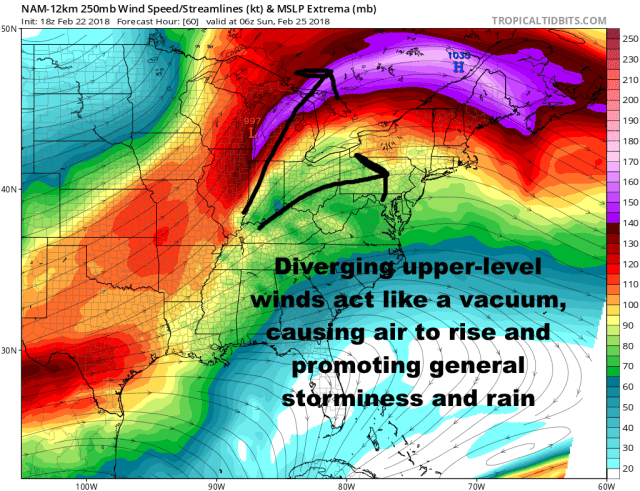
Modelled upper-level winds Saturday night across the eastern US
In addition to all of the moisture moving into the region, we’ll be located beneath a favorable upper-level wind pattern for storminess and precipitation. Being to the south/southwest of a strong region of jet stream winds, known as a “jet streak,” is known for being active and stormy, as that area relative to a jet streak sees upward motion. This will promote numerous waves of low pressure and enhanced rain chances moving through the region between late Thursday night and Sunday morning.
TIMING THE HEAVY RAIN:

Model forecast radar and fronts valid 10:00AM Friday
The next round of rain will be late Thursday night and Friday morning as a low pressure tracks into the northern Great Lakes. This will pull a warm front across Ohio Friday morning, and push a cold front across the state during the afternoon. This process will cause another round of rain and even some embedded thunder across much of the state. Rainfall amounts with this round will be about a quarter to half an inch across northern Ohio and a half inch to inch across central and southern Ohio. This may prolong any ongoing river flooding from recent rain and slow the recession of any other lingering flooding…and could cause some new flooding, especially across central and southern Ohio where they’re most vulnerable and where the heaviest rain is expected to fall.
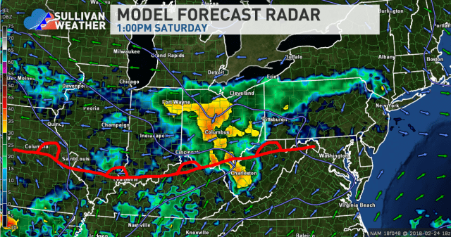
Model forecast radar and fronts valid 1PM Saturday
The next round of heavy rain will really be a two part hit from one strong low pressure tracking into the northern Great Lakes. The first part will be a shot of moderate to rain, along with some embedded thunder, ahead of the warm front during the day Saturday. This may drop a widespread one half to inch and a half of rain across the state late Friday night through Saturday, with locally higher amounts possible if any areas see repeated or “training” heavy rain/thunder. A relative lull in the rain is possible late Saturday afternoon and early evening, but…

Model forecast radar and fronts valid 1AM Sunday
More rain and storms will move back in late Saturday evening through early Sunday as the cold front approaches and moves through Ohio…bringing another widespread three quarters of an inch to inch and a half of rain to much of the state, with locally higher amounts possible if anyone sees repeated or “training” heavy rain/storms. This will all cause flood concerns across the state, with both quick “flash” flooding possible when the heaviest storms occur and river flooding after the rain due to the added effects of each shot of rain.
We finally dry out fairly quickly Sunday morning, with no substantial rain expected during the first half of next week.
THE RESULTS:

Much of the state will see one to locally four inches of rain this weekend, with the highest amounts likely where any heavy rain/storms repeatedly track. All of the state is vulnerable to heavy rain and flooding right now, with the areas worst off being parts of central and southern Ohio where the best shot at a few inches of rain is. Much of the state can expect at least some minor flooding issues through this weekend, with significant issues possible in central and southern Ohio. We will need to watch the northern edge of the heaviest rain closely, as any adjustment north could bring more significant flooding north of the current flood watch area.
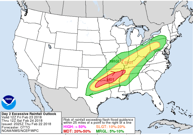
Excessive rainfall outlook for Friday-Friday night from the Weather Prediction Center
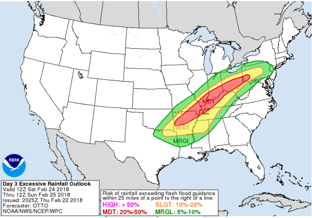
Excessive rainfall outlook for Saturday-Saturday night from the Weather Prediction Center
There is currently a slight risk (risk level 2 of 4) for excessive rain and flash flooding across parts of central and southern Ohio for Friday and Friday night from the next round of rain, and a slight to moderate risk (risk levels 2 of 4 and 3 of 4) for central and southern Ohio for Saturday and Saturday night. There is a marginal risk (risk level 1 of 4) for northern Ohio both time periods. These outlooks are issued by the National Weather Service’s Weather Prediction Center.
These risks indicate the potential for rain heavy enough to cause flash flooding in a given area in each timeframe. Flash flooding is when heavy rain causes rapid water rises, typically in urban areas and along smaller creeks and streams. A moderate risk indicates a 20-50% chance of this occurring, which is substantial. As discussed above, some flooding may occur from the round late tonight into Friday, but the more substantial rounds look to be Saturday through early Sunday.

Forecast river crests at gauges across the region from the Ohio River Forecast Center
In addition to the potential for urban and small stream flooding as the rain is ongoing, the repeated heavy rain over a large area will cause many main stem rivers to rise and potentially flood. Most larger creeks and rivers are expected to approach or hit flood stage through the weekend in Ohio. It’s worth noting the flooding on northwest Ohio rivers is mainly from rain that’s already fallen.
Of particular concern is the expectation of a major flood to move down the Ohio River later this weekend into early next week, with crests at moderate to major flood expected all along the Ohio River. Some gauges may even approach record levels. Other larger rivers in parts of east-central and southeastern Ohio will also likely flood.
You can monitor real-time river levels and forecasts here:
In general, a lot more rain is coming, and this will cause new flooding across the state. In parts of southern and central Ohio, this flooding may be widespread and significant. Flash flooding in urban areas and on smaller creeks/streams as the rain is falling, river flooding on larger waterways, and flooding/standing water in any low-lying and/or poor draining areas will all be concerns this weekend. If you live in a flood prone area and are ordered to evacuate, heed those orders. Monitor any streams, creeks, and rivers near your location for rises through the weekend. If you come across a closed or flooded road…many of which are likely…never drive through them. Remember, turn around, don’t drown! The good news is next week looks much quieter, giving us a chance to dry out.
