
Technical Discussion:
A flare-up of snow is beginning to occur as of this writing (4:30PM), with an area of light synoptic snow moving across Lake Erie and grazing the lakeshore. There may be a bit of lake enhancement of this snow, with some moderate bursts possible. This will pull east pretty quickly by early to mid-evening, but may drop less than an inch in NE OH east of Cleveland and perhaps a quick 1-2” in Erie County, PA. Behind this wave of synoptic moisture driven by some weak mid-level deformation lake effect conditions will improve this evening. Winds will be fairly well aligned at 275-285 in the lowest several thousand feet, with steep lapse rates and good moisture up to 9-10k feet. In addition, a disorganized area of numerous snow showers from Lake Michigan will move east across Lake Erie into the central lakeshore and NE OH Snowbelt this evening for a few hours, providing good pre-conditioning. A little 700mb vort max will also move across the lakeshore counties providing for some upward motion below 700mb. Given all of these generally favorable conditions, some bursts of decent snow are possible from Lorain County (and perhaps extreme northern Medina and Summit Counties) points east this evening mainly between 7pm and midnight. After midnight, winds back a bit and start pushing the Lake Michigan moisture and lake effect up the shore into the northern primary Snowbelt in NE OH and into NW PA. Some sinking motion behind the 700mb vort max and a bit of drying in the mid-levels will likely cause the lake effect to become less intense after midnight, though I’d imagine some snow showers will continue in the northern Snowbelt overnight and into early Thursday. Increasing convergence early Thursday morning may focus a weak band across the lakeshore from Lake County northeast through Erie County, PA.
All in all, I don’t think the lake effect will be organized or long-lasting enough for a big accum tonight, but I’ve seen these types of setup (deep instability/good pre-seeding, with fairly light winds) produce pretty impressive bursts of snow that can drop an inch or two in an hour or less. Snow growth isn’t optimal, with some lift in the DGZ this evening but the best lift below it. This may result in some graupel at times and ratios not much above 10:1. So, I think I’ll go with a general 1-3” from parts of Lorain County and the Cleveland metro points east. If a better convergence band can organized into extreme NE OH or NW PA near the lake later tonight, that may allow for some 3-4” amounts, especially since those areas may see a little more from the brief shot of synoptic snow this evening.
The lake effect should briefly lift out over the lake for everyone in OH and PA Thursday morning as winds turn SWrly. Synoptic snow will increase Thursday afternoon and peak late afternoon and early evening as a number of things happen. A compact surface low will drop SE across eastern Lake Erie during the late afternoon and early evening. The low will likely open up by evening, but will cause a sharp trough and broadly cyclonic and convergent low-level flow on the back-side of it that will push inland off the lake during the late afternoon. There will also be some low to mid-level frontogenesis along the aforementioned trough axis west of the low as some modified Atlantic air wraps all the way around the storm and comes in from the north. In addition, there will be a very strong vort max with the closed 500mb low that will drop right into the Cleveland area. All of these sources of lift…along with steep lapse rates and deep moisture up to around 500mb due to 500mb temps of colder than -35C…will cause moderate to heavy snow. It wouldn’t shock me if there was some lightning along any stronger convergence-driven bands of heavier snow given the deep layer of steep lapse rates. Given the deep layer of instability, some lake enhancement, and multiple sources of decent lift, snow rates may hit 2-3” per hour late Thursday afternoon and evening for brief periods with any better bands of snow focused by low-level convergence.
Am thinking the best period of snow will last about 3 hours in any given area, but may coincide pretty well with the Thursday PM commute and may quickly but down 2-5” of snow in 3 hours, locally more if there are some well-defined bands. Temps will be right near freezing, but good snow growth and heavy rates should allow for ratios a bit higher than 10:1 despite the somewhat milder surface temps. Right near the lake may sit a little bit above freezing which may slow accums a bit near the lake, but if it snows hard it will accumulate. There may be some snow showers for a few hours ahead of the best burst that may produce an inch or so, especially in the higher terrain.
There is some disagreement with the exact low track, with some models trying to take the low a little farther west and drop the best snow west of Cleveland. I tend to think the low will hug the relatively warmer waters of Lake Huron and Lake Erie and stay on the eastern side of guidance. The more consistent models such as the Euro ensembles, UKMET, Canadian, and hi-res NAM since last night agree on the best snow going into the Cleveland metro and NE OH Snowbelt. NW PA should see a burst in the evening, but the best will likely be in NE OH. My forecast is based on the premise that the best snows with the system Thursday late afternoon and evening will be from the Cleveland metro east, but mainly west of NW PA.
Behind the potentially furious burst late Thursday, some lighter snow will linger Thursday night into Friday morning. Some mid-level isentropic lift could keep patchy light synoptic snow going, as modified Atlantic air continues to ride up the core of the colder air with the upper-level low pulling away to the ESE. This, along with 850mb temps around -10C and plenty of low-level moisture, along with a WNW flow, will keep light to moderate snow going in the Snowbelt. The flow may remain somewhat convergent behind the low for the rest of Thursday evening, perhaps allowing for some corridors of more organized snow. Also will have to watch the zone from Lorain and Medina Counties east across the southern NE OH Snowbelt, as a flow around 290 or so often focused some convergence in that corridor that may keep moderate snow going for a longer period of time.
One last shortwave moves through late Friday morning/early afternoon, which may keep some light to locally moderate lake effect/enhanced snow going until about noon. Winds look 280-290, so the snow will likely be focused from Cuyahoga County (and perhaps northern Lorain and extreme northern Summit) points north/east Friday morning, with the heaviest in the higher terrain where good low-level moisture will continue to promote orographic enhancement.
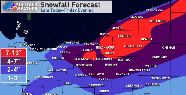
In terms of total accums…thinking 1-3” tonight (locally 3-4” extreme NE OH into parts of Erie Co)…and then a general 4-8” Thursday afternoon through Thursday night in the primary NE OH Snowbelt, with 3-6” in the secondary Snowbelt and probably 2-5” in NW PA. If any persistent areas of convergence linger in NE OH, some locally higher amounts may occur Thursday night. Expect another 1-3” Friday morning from Cuyahoga County and perhaps extreme northern Lorain/Summit points north-east. Snow showers will continue into Friday evening but will add up to little additional accumulation. This gives totals of about 5-10” in NW PA (best shot at 10” in the higher terrain of Erie County)…about 6-14” in the higher terrain of the NE OH Snowbelt (will call it 7-13” to trim the range a bit)…and a good half foot or so for parts of the secondary Snowbelt south of Cleveland. Will drop amounts off to the southwest, though much of northern OH could see some light accumulations from the synoptic snow.
Here’s my map at this point, which includes the snow falling now.
