
Disclaimer: The thoughts in this post are only mine and don’t represent the thoughts of any other companies, groups, websites, or organizations. They also shouldn’t be used for decision making in the impacted areas…
The majority of the satellite and model images in this post are courtesy of Tropical Tidbits. Any poorly drawn illustrations on the images are my own.
Now the post…
Key takeaways at this point:
- Florence is unlikely to take the early recurve out to sea this weekend, meaning it will get into the western Atlantic and put Bermuda on guard during the first half of next week…and the East Coast on guard starting around Wednesday.
- Whether or not Florence actually manages to hit the East Coast directly or recurves out to sea with much more minor, indirect impacts is impossible to determine at this point, as it will come down to finer-scale details that can’t be accurately forecasted at nearly a week out. At this point it should be stressed that less than half of all available, reliable guidance actually directly hits the coast, but that most data does at least get it close with a smaller portion actually hitting directly. The threat is there, but nothing is a given this early.
- Florence has weakened dramatically over the last 12-18 hours and further weakening is expected into the first half of the weekend.
- Re-intensification, quite possibly back into a major hurricane for a time, is likely as we head into early next week as Florence tracks into the western Atlantic.

Current satellite imagery of Florence
Hurricane Florence basically did everything I said it wouldn’t do over the last couple of days. It defied a marginal environment and intensified rapidly, to at one point a category 4 hurricane in an unusual location that far north in the eastern Atlantic, and also stayed on the northern side of the envelope of possible forecast tracks over the last couple of days. Why it intensified despite expected moderate shear, dry air, and marginal water temps (SSTs) is a little bit beyond me…it’s possible the storm itself was able to create a small bubble of little shear in its immediate vicinity or that some sort of internal dynamics fought off the shear for a couple of days.
The above satellite image is much less impressive than what we were seeing yesterday…Florence is exhibiting a smaller area of deep convection (with warmer cloud tops), with no discernable eye or eyewall on convectional imagery. The center is located near the southwestern edge of this deeper convection, with outflow still good in the northern and eastern quadrants but very restricted/missing in the southern and western quadrants.
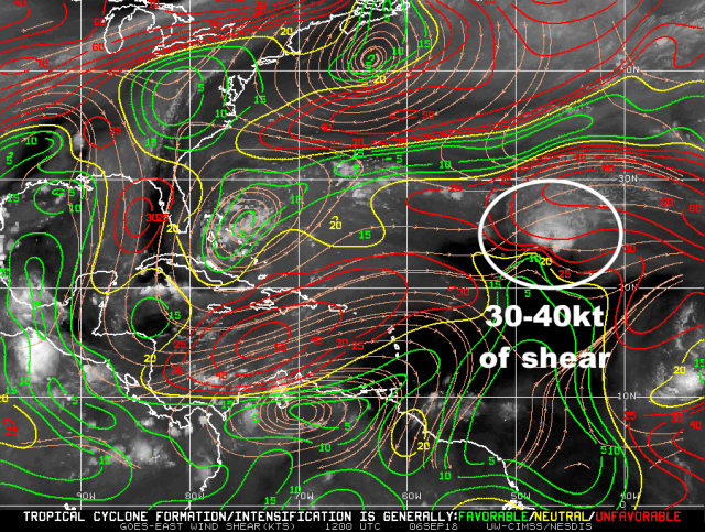
Current analysis of wind shear across the Atlantic showing 30-40 knots of shear over Florence
We appear to be at the point where whatever mechanism that was fighting off the shear has finally been overwhelmed, as 30-40 knots of westerly/southwesterly shear have clearly had an effect overnight. The storm will end up weakening from a category 4 to a category 2 in the matter of 18 hours by the time the 11AM EDT advisory comes out. Florence will be tracking through this belt of strong west/southwest shear for another couple of days, and further weakening is likely.

Current analysis of the “Saharan Air Layer” (dry air), with the layer showing up in yellows/reds
It does not help matters that Florence is still in proximity to some mid-level dry air courtesy of a Saharan Air Layer. The west/southwest shear will tilt Florence’s circulation to the east/northeast with height, making it more prone to dry air entrainment than it’s been. Shear won’t abate until somewhere around Saturday, and don’t be surprised at how much another full day or two of strong shear/dry air entrainment can weaken Florence (considering it’s already weakened quite a bit)…this very well could be a tropical storm by the time conditions start becoming more favorable for it to strengthen again over the weekend.

GFS model forecast upper-level winds valid Sunday evening
Florence is expected to move north of the belt of inhospitable upper-level conditions by Sunday and into early next week. Ironically, the weak upper-level disturbances shearing it now may end up acting as outflow channels that help intensify the hurricane into early next week as it tracks into the western Atlantic. The jet stream to the north could also help with ventilating the hurricane in the upper-levels.

Current SSTs across the Atlantic basin
Florence will also be moving over increasingly warm SSTs over the next several days, considerably warmer than what it was over on Wednesday as a category 4. This, combined with the expected favorable upper-level wind pattern, will likely foster re-intensification into early next week…likely back into a major hurricane.
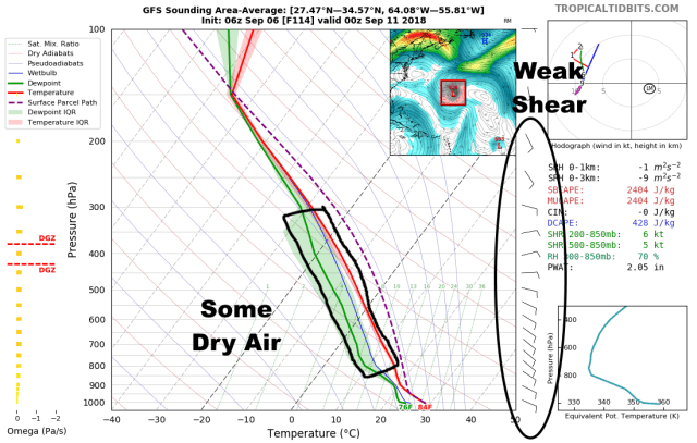
GFS model forecast sounding for the environment surrounding Florence on Monday. The plot shows winds with height on the right, and temperature/humidity in the middle. The red line is temperature, green line is humidity. The gap between the two represents some dry air.
This is still a kind of delicate situation, as forecast soundings show dry air continuing to be perhaps somewhat of a hindrance to intensification into early next week…500-850mb RH is 70% on this storm-averaged sounding from the GFS, which is on the margins of being unfavorable. If shear is in fact weak (less than 10 knots) as the GFS and Euro both show, this won’t be a significant issue, but if shear fails to weaken below about 10 knots, then dry air intrusions would slow re-intensification. At this point I suspect that given the favorable SSTs that once Florence moves north of the strongest shear over the weekend that the strong outflow will favor deep convection over the center that allows it to intensify pretty quickly…but, we’ll need to see exactly how much of a toll the next couple days of unfavorable conditions has on the storm.
Long story short on the intensity, expect continued weakening (potentially rapid) through Friday and into Saturday before re-intensification. How quickly it re-intensifies is up in the air, but there appear to be enough “positives” for intensification that Florence will be a hurricane and likely at times a major hurricane again over the western Atlantic early next week.
As for the track forecast…
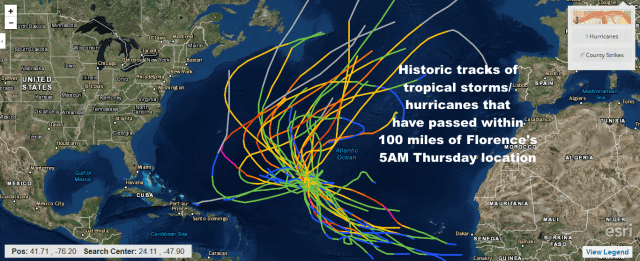
Track of all tropical storms or hurricanes on record that have tracked within 100 nautical miles of Florence’s Thursday morning position
The first comment is that we should keep in mind the historic precedent…no storm that has tracked within 100 miles of Florence’s 5AM Thursday location as a tropical storm or hurricane has struck the US. So, we’d need an unusual pattern to see that happen here…it does appear we’ll have that.
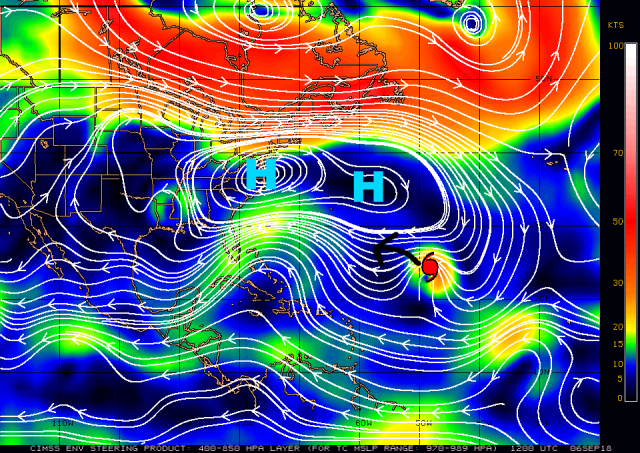
Current steering flow across the Atlantic Ocean (Thursday morning)
In the short term, Florence will likely start slowing some to end the week and into the weekend and turning more “left” or back towards the WNW (instead of the recent NW heading) as ridging builds in to its north. Florence will be weakening over the next day or two as mentioned above, and this will make it more prone to getting shunned to the left by the ridge to its north.
European ensemble mean upper-level weeather pattern valid Saturday evening
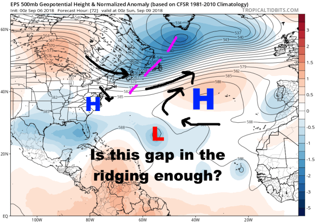
As we head into the weekend Florence’s initial opportunity to recurve comes up on us for Saturday night-Sunday as a weakness in the ridging briefly opens up to the north of the storm. For a number of reasons, a recurve at this juncture now looks less likely that it did a couple of days ago:
- The trough to the north does not dig as far south, resulting in the ridging breaking down later, less, and building back in quicker
- Florence will be moving rather slowly (note the random, and not particularly strong steering currents ahead of Florence), and may not gain much latitude before ridging builds back in
- Despite Florence’s unexpected intensity this week, it’s expected to be near the pinnacle of its weakening trend when this weakness in the ridging briefly opens up. Florence being weak when its brief escape hatch is open decreases its chances of taking it.

European ensemble mean upper-level weather pattern valid Sunday evening
The weakness in the ridging north of Florence closes quickly, within a day, as the trough over the north Atlantic quickly zips off to the east-northeast and ridging builds back in. Given all of the reasons mentioned above, Florence likely doesn’t get to hit the weakness in the ridging before it closes, which would force it to turn back more to the west into the western Atlantic as what will likely be an intensifying hurricane.

European model ensemble mean upper-level weather pattern valid Tuesday evening
As has been the fear all along here, if Florence misses the early recurve (now expected), the anomalously strong ridging over the western Atlantic would force Florence to move west to dangerously near the US East Coast. That is still expected, and Florence will in all likelihood make at least a dangerously close approach during the second half of next week.
Whether or not Florence gets close, but then turns away, or is able to make landfall is still unknown and may ultimately come down to finer details that just can’t be resolved at this range.
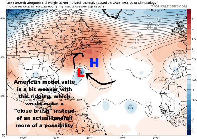
American model ensemble mean upper-level weather pattern valid Tuesday evening
For instance, the GFS ensemble (American model) has a little bit less riding over the western Atlantic, which would make the “close call” scenario more likely than the European solution, which has a stronger ridge and makes a direct landfall more likely.
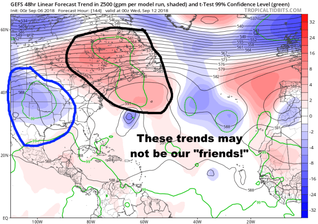
Trends in the upper-level weather pattern among the last several runs of the “American” model ensemble
With that said, even the GFS ensemble has had some concerning trends over the last several runs…towards a stronger ridge over the western Atlantic, and perhaps a bit of a trough over the southern US, which could not only help intensify the ridge but also perhaps pull the storm west if located in the correct location…many East Coast hurricane hits have some sort of trough over the Ohio or Tennessee Valley that helps pull a storm more north-northwest instead of letting it just curve around a ridge.
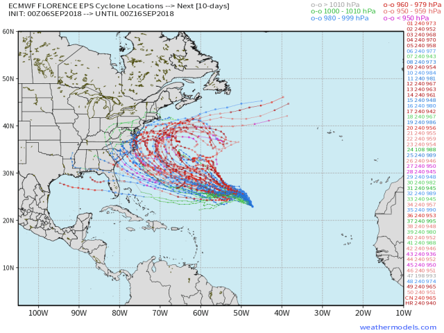
Wednesday night’s European ensemble member track forecasts for Florence, showing a wide spread of possible solutions
Last night’s European ensemble has continued the trend of the last few cycles of going from just a small cluster of members getting Florence into the western Atlantic to nearly every member missing the early recurve and getting the storm into the western Atlantic. A little less than half the members actually hit the US directly, but that’s still up from previous runs, and even most of the misses are just off the coast and close enough for at least indirect impacts (dangerous surf, beach erosion).
The big takeaways at this point are that Florence is likely getting into the western Atlantic, putting Bermuda and the East Coast on guard. It’s still simply too early to tell if this will directly hit the coast or simply curve away just off the coast with more minimal impacts.
Factors that could make a hit more likely would be the upper-level trough over the southern US coming in a bit deeper, perhaps pulling the storm more west as it rounds the western edge of the ridge. The ridge itself being stronger or located farther west would also inherently force Florence to track farther west, increasing the risk for an actual landfall.
A weaker ridge overall, or the ridge being located just a bit farther east, would make the “near miss” scenario more likely to pan out.
Ultimately it’s too early to know any of these details, at this point we just know that some sort of threat is there for the second half of next week for the US East Coast (and Bermuda during the first half of the week). The ridge’s location would likely make a direct hit on the Long Island/New England area harder to come by…I think if this hits the US directly it more likely does so in the Mid Atlantic or Carolinas.
