
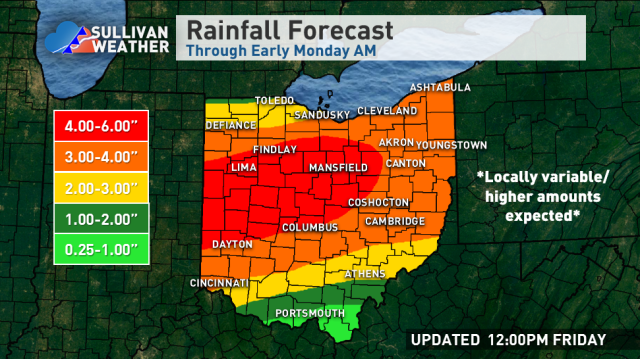
The remnants of Tropical Storm Gordon will move across the southern Great Lakes as a non-tropical low-pressure this weekend. This will combine with a front, the jet stream, and lingering tropical moisture to wring out quite a bit of rain across a good portion of Ohio. The potential exists for some areas to get heavy rain, which will cause flooding concerns. Here’s the quick summary:
-There will be some rain today and tonight in southern and central Ohio, though except for perhaps localized issues close to the Indiana boarder this won’t be the heaviest portion of the event
-Rain will gradually become more widespread and heavy as Saturday afternoon wears on
-The heaviest rain will likely start in western Ohio late Saturday and gradually work east-northeast through the state through Sunday evening. Northeast Ohio won’t get into the heavier rain potential until late Saturday night or Sunday morning
-Except for a few localized exceptions, much of the state hasn’t been that wet lately and can generally handle some rainfall without flooding. The concern will be for prolonged tropical downpours that may cause flash flooding later this weekend where they occur, and also in areas that do see several inches of rain, which will likely be enough to cause river flooding concerns despite the recent dry conditions
-Embedded areas of heavy rain and thunder will ultimately drive the heavier totals. This will be inherently a little bit inconsistent. I expect most areas to get a good amount of rain, but only areas that get hardest will see the upper end of these totals
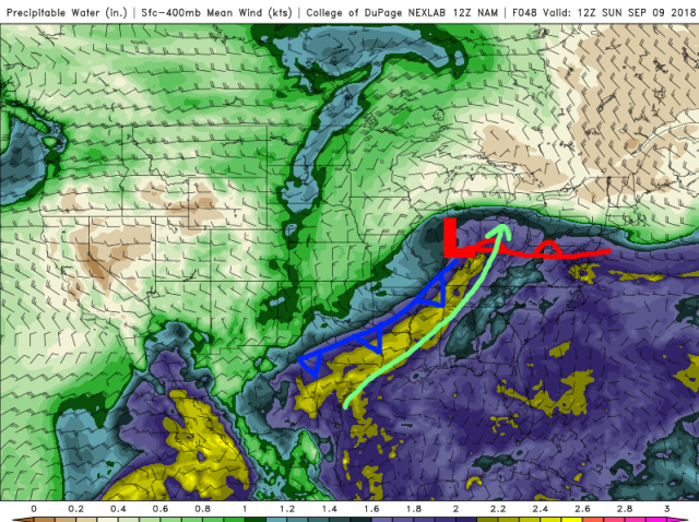
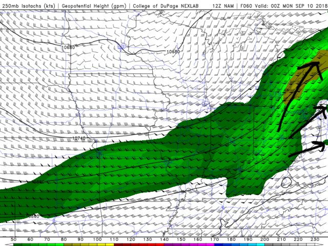
Modeled fronts, low to mid-level flow, and atmospheric moisture valid Sunday AM
The non-tropical area of low pressure associated with the remnants of Gordon will move northeast across the southern Great Lakes Sunday into early Monday, bringing periods of heavy rain to Ohio as the lift from that low pressure, the fronts, and the jet stream interact with the tropical moisture being drawn north.
I can’t rule out a few slow-moving downpours/storms with locally heavy rain mainly in far west-central or southwestern Ohio this Friday afternoon/evening, but the meat of this heavy rain event doesn’t really start taking shape until Saturday afternoon…
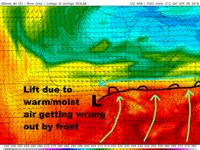
Model forecast mid-level winds and temperatures/humidity valid late Saturday PM
This will start occurring when the low to mid-level flow starts increasing across the Ohio Valley. This will essentially cause moisture to get squeezed/wrung out by the front into central and southern Ohio.
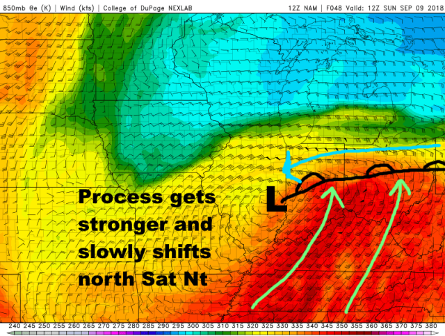
Model forecast mid-level winds and temperature/humidity valid early Sunday
As the low intensifies and slowly moves northeast Saturday night into Sunday, the lift along the front in the low to mid-levels will also get stronger, making heavy rain more likely. This process will only slowly shift north, so the concern is for some areas to get at least a few hours of moderate to heavy rain with decent rainfall rates Saturday night into Sunday as the warm frontal zone slowly lifts across the state.
The warm front likely gets close to Lake Erie by Sunday afternoon, so a round of heavier rain is likely well into northern Ohio, though it will probably take into late Saturday night or Sunday morning to get there.
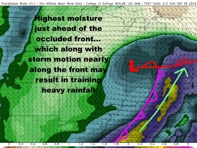
Aside from the heavy rain from the warm frontal lift, the cold/occluded front will slowly move west to east across Ohio Sunday into Sunday evening, sparking more locally heavy rain/storms that may not be short-lived in some spots:
Modeled fronts, low to mid-level winds, and atmospheric moisture Sunday afternoon
The occluded front will slowly move across the state Sunday into Sunday night, and with the highest moisture being just ahead of this front and storm motions being nearly parallel to the front, some training rain/storms with heavy rainfall rates will be a concern Sunday into Sunday night as the occluded front moves slowly east across Ohio.
Some instability will gradually build north Saturday night into Sunday, and be maximized Sunday into Sunday night ahead of the occluded front the pushes east. The instability won’t be that strong, but will enhanced the potential for embedded heavy downpours:
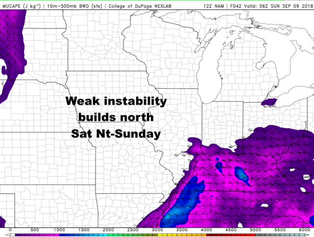
Model forecast instability valid overnight Saturday night
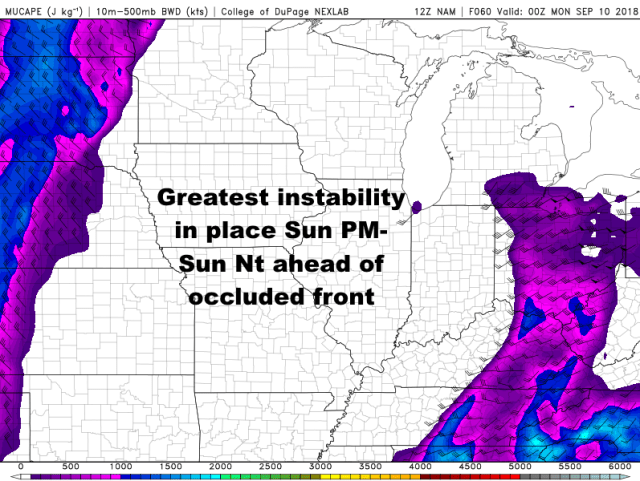
Modeled instability valid late Sunday afternoon
In addition, the upper-level winds will be in a favorable, diverging pattern both Saturday night into Sunday morning as the warm-frontal rain is lifting north, and Sunday evening as the occluded front pushes east:
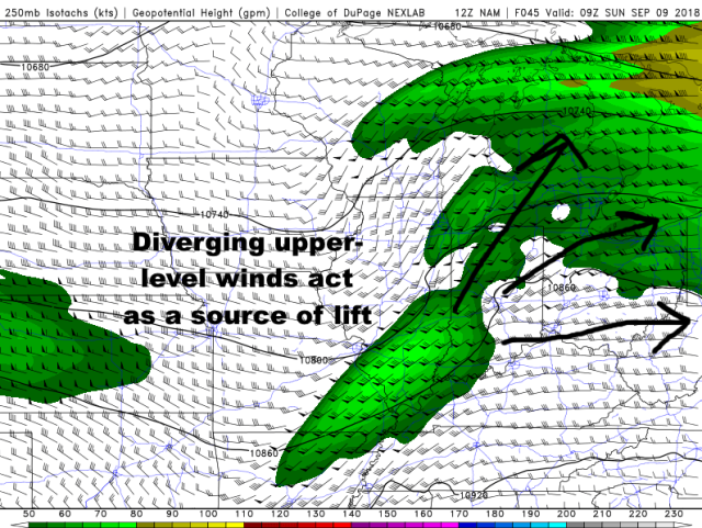
Forecast upper-level winds valid late Saturday night/early Sunday morning
Forecast upper-level winds valid Sunday evening
This will also further increase the potential for widespread rain with embedded moderate to heavy rain…
Essentially, many factors are aligning for heavy rain later Saturday through Sunday night…
-Strong lift from warm front slowly lifting across state
-Additional lift moving across the state shortly thereafter as the occluded front pushes east
-Large-scale upward motion due to favorable jet stream dynamics as both above processes occur
-A warm, very moist airmass that will promote heavy precipitation rates
-Weak instability, which will enhanced the potential for embedded heavy rain.
Weak instability in a warm, very humid airmass with multiple sources of lift is about the best way to maximize potential rainfall rates. Embedded heavier rain/thunder could produce rain rates in excess of 1” per hour at times, and much of the state will see multiple opportunities of at least a few hours for heavy rain. The rain will be inherently a little inconsistent because it’s summer, but where the stars align there will be several inches of rain.
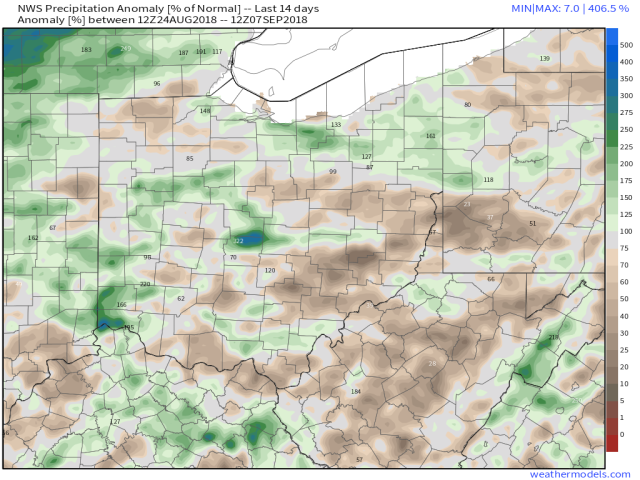
Observed rainfall percent of normal over the last 14 days
Over the last two weeks, rain has generally been at or a bit below normal across most of Ohio. A few big exceptions, and those areas will be more vulnerable this weekend, but in general rivers aren’t running that high going in and the ground isn’t too saturated…so we can take some rain. However, prolonged heavy rates would still cause flash flooding, and several inches over a large area will overwhelm and flood some rivers, so the risk for flooding is certainly elevated this weekend, and those in flood prone areas should be prepared for the potential. River flooding, flash flooding of streams and creeks, and roadway flooding will all be concerns given the potential for heavy rates and high amounts over a large area.
