

Infrared satellite image of Dorian as of early Tuesday evening
(When dealing with tropical cyclones and other adverse weather, always follow the advice of local officials for your safety)
Dorian, a sputtering Tropical Storm between the Lesser Antilles and Puerto Rico over the eastern Caribbean that has its eyes set to the west-northwest towards Puerto Rico, the Dominican Republic, parts of the Bahamas and eventually parts of the Southeastern U.S. A lot of uncertainty is involved in both the track and intensity forecast for Dorian over the next several days, meaning potential U.S. impacts range from very little to potentially significant, so let’s try to break it down.
The satellite appearance of Dorian continues to leave something to be desired, with intermittent bursts of deep convection that struggle to maintain long enough for substantial intensification due to very dry air surrounding the storm that continues to get entrained into the circulation. Outflow is decent especially given the storm’s small size.
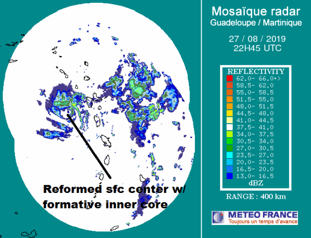
Radar image of Dorian from early Tuesday evening
Dorian was terribly disorganized earlier Tuesday with a significant SW to NE tilt to its vortex…since then, aircraft reconnaissance and eastern Caribbean radar suggest the surface center re-formed north, closer to the more persistent convection. Radar has shown some formative attempt at some inner core structure with a curved band wrapping partially around the circulation, though for now, the continued intermittent/bursting nature of the convection will likely keep short-term intensification from getting out of control, and current aircraft recon finds that Dorian has remained rather steady (perhaps modestly intensified) since the last plane was in there earlier this afternoon.
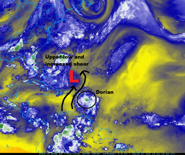
Water vapor imagery from early Tuesday evening showing Dorian, dry air surrounding it, and an upper-low in front of the Tropical Storm
As for what lies ahead in the short term…dry air will continue to dominate the environment around Dorian until it gets north of the Greater Antilles, and shear will increase by Wednesday as Dorian encroaches on an upper-low and enhanced southerly upper-level winds to its west. This upper-level dropsonde from around 5:30 PM EDT shows a notable amount of shear above 500mb along with a very dry environment near the inner core of Dorian…the shear will only increase more into Wednesday.
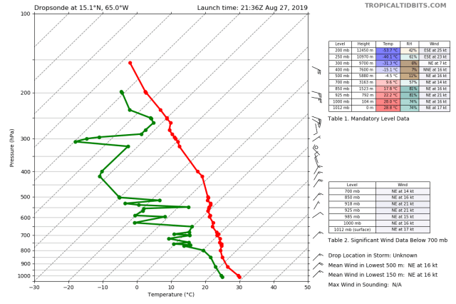
Upper-level dropsonde near Dorian, showing very dry air (separation between red [temperature] and green [dew point]) and some wind shear (barbs on the right-hand side)

Mean low-mid level flow as of early Tuesday evening
In the short term, Dorian will turn northwesterly as it approaches a fairly large weakness in the sub-tropical ridging to its north. This northwest turn, along with Dorian’s center reforming farther north early this afternoon, essentially guarantees that Dorian will not track over or even that close to the Dominican Republic…however, a track over or extremely close to Puerto Rico seems very likely now.
Between Dorian’s small size/fairly weak nature…moderate shear and continued dry air intrusions over the next couple of days…and land interaction with Puerto Rico on Wednesday (and perhaps some indirect interaction with Hispaniola), there may very well be a net weakening through late Thursday. Many global and dynamic hurricane models suggest this. However, with much less interaction with the very mountainous Hispaniola, some increase in organization since Tuesday morning, and only 24-36 hours of markedly stronger shear, it seems considerably more likely than not (though still not 100% certain) that Dorian makes it north of the Greater Antilles as a tropical cyclone.

Forecast upper-level winds over the western Atlantic on the GFS model, valid Saturday morning
Should Dorian survive the next 48 hours, conditions will be considerably more favorable for intensification beginning Friday and through the weekend over the Bahamas. The upper-low bringing increased shear over the next couple of days is expected to dissipate as an upper-level anti-cyclone develops over Dorian, bringing very light shear. In addition, multiple outflow channels may develop, with a potential jet streak to the north being particularly concerning. I find it worrisome that global models are developing this favorable environment before they really deepen Dorian, leading me to believe there’s a good chance this environment isn’t strongly/perhaps incorrectly influenced by Dorian on the models.

Mid-level relative humidity forecast from the GFS model, valid Saturday morning
In addition to reduced shear, Dorian will find much less dry air north of the Greater Antilles this weekend. While it may take some time to mix out the already-entrained dry air Friday-Saturday, the much moister ambient environment and lower shear, along with Dorian’s small size, should ensure that the process happens reasonably quickly.
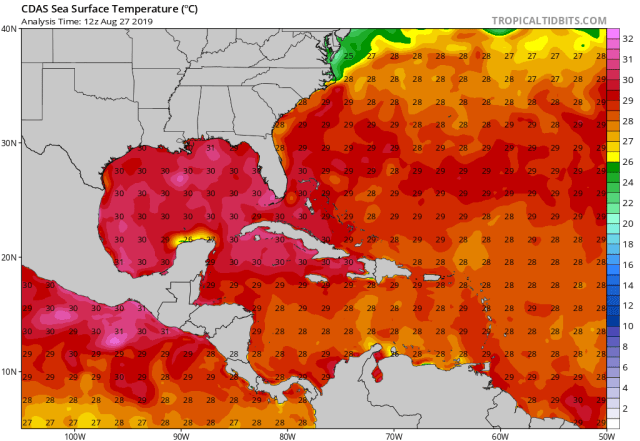
Water temperatures across the western Atlantic Ocean
The waters beneath Dorian will also be quite warm this weekend (and are warm to a sufficient depth). The combination of a small storm, low shear, strong outflow, a moist environment and plenty warm waters could result in significant intensification starting Friday or Saturday as Dorian tracks northwest towards the northern Bahamas if the system can maintain a closed circulation through Thursday. A high-end hurricane would be possible if all goes properly, and some recent modeling is pointing towards that solution. There’s likely a middle ground solution between the (unlikely) total dissipation over the Greater Antilles and the much more troubling “holds together now, major hurricane later” that involves Dorian opening up into a trough over the next couple of days, but re-developing into a tropical cyclone this weekend. That would likely put some sort of a cap on the future intensity of Dorian as it nears the northern Bahamas and threatens Florida, though still may have impacts if the storm hits land.
It’s ultimately still a little too early to know with much confidence how strong Dorian will be by Sunday or Monday, with that answer becoming clearer by Thursday when we see how Dorian fairs in a more hostile environment with some land interaction starting on Wednesday. The environment and some modeling over the weekend is alarming, but we should not over-look the shorter-term questions and sound too many alarms yet…a heightened state of awareness in areas potentially affected is warranted though.
Large-scale weather pattern predicted by the European ensemble Saturday morning
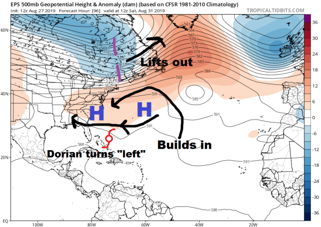
Dorian will continually generally on a northwest track through the end of the work-week. By Saturday, a trough over the Northeast U.S. will lift out and sub-tropical ridging will build back in over the Southeast, pushing Dorian more “left” and causing a bend back to closer to a westerly than northwesterly motion.
Dorian’s northwest motion in the meantime may take it largely north/east of the Turks and Caicos (perhaps grazing the eastern islands), though the turn back to a closer-to-west motion this weekend may bring it very close to or into the northern Bahamas.
The next item of interest is of course Florida, as the pattern as shown on Saturday above would push the storm towards the eastern Florida coastline as a strengthening storm. This is where uncertainty increases…it is very likely Dorian at least approaches the Florida peninsula due to the ridge build in to its north to start the weekend, but does it keep going until hitting the coast?
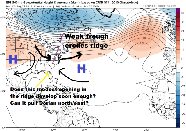
Large-scale weather pattern predicted by the European ensemble Monday morning
There is still uncertainty regarding the final approach/potential impact to Florida, as a weak, progressive shortwave trough is expected to zip through the Northeast Sunday into Monday, eroding the ridging north of Dorian a little bit. The exact speed and amplitude of this trough along with Dorian’s location, size, and intensity will determine if this shortwave has much/if any tug on Dorian and potentially allows it to recurve just east of the Florida coast. The window for this occur is small as the trough zips east and ridging builds back in Tuesday into Wednesday next week.

Hemispheric forecast weather pattern from the European model valid Saturday morning
The hemispheric view shows the delicate/uncertain nature of the exact evolution of the fairly flat/progressive shortwave that may open up a weakness in the ridging Sunday/Monday north of Dorian. The exact amplitude of that shortwave will be influenced heavily by a ridge over the western US (and to some extent by a large trough over eastern Canada). That ridge out west is influenced by a number of features over the northern Pacific…so a lot can still change. It’s a narrow window to recurve before hitting Florida, with a number of features causing a lot of uncertainty this far in advance.

GFS ensemble pattern forecast “trends” over the last two days’ worth of runs, valid Sunday morning. Reds indicate a trend towards more ridging, blues towards more troughing
The GFS ensembles don’t show an encouraging trend in that regard, with the ensembles trending towards the trough hitting the Pacific NW earlier/stronger, raising heights over much of the northern/central U.S. and likely dampening out our shortwave even more.
So, long story short, Dorian if it holds together the next two days will likely get very close to or hit Florida Sunday or Monday as what could be an intense hurricane. However, uncertainty over its fate over the next couple of days, along with a very delicate forecast for the pattern steering Dorian near the Florida coast, makes it way too early to make any sort of proclamation about how this story ends. Needless to say, Florida has a storm to definitely watch closely, with nearby areas such as the Southeast (should it turn north and just miss Florida) and the Gulf Coast (should it not turn north and continue west) also needing to closely monitor Dorian.

European ensemble forecast tracks for Dorian through the next 10 days
The European ensemble tracks show the risk to many areas (and huge uncertainty) well…the storm will make a WNW “turn” towards Florida this weekend (assuming it holds together)…does it keep going west-northwest into the peninsula (and possibly into the Gulf), does it slow down and turn just offshore (possible threatening Georgia or the Carolinas), or is something else on the table? And how strong is it? Lots of questions…as is often the case at this distance out not many answers, but plenty of reason to closely watch this one.
