
Updated thinking on the lake effect tonight through early Sunday off of Lake Erie…
A band will ramp up over the lake this evening by 7 or 8 PM as the first of a few troughs pushes across the lake. Winds ahead of the trough are WSW if not SW, so this initial band will likely set up parallel to the shore and come inland into Buffalo and its immediate southern suburbs. Temperatures ahead of the trough are cold enough for plenty of graupel given the developing instability, but don’t quite get cold enough for a change to all snow and potential accumulations until after it passes. This band will likely push inland a bit and shift south of the Buffalo area by 11 PM or Midnight as the trough passes. Winds behind this trough briefly come around to about 270 (due west) over the lake and remain firmly south of west overland. This will likely push the trough into Erie County PA within 10 miles of the lake (as well as Chautauqua/northern Cattaraugus NY)…it will probably be able to graze Lake//northern Geauga/Ashtabula Ohio but will not push far inland. As the trough pushes through temperatures will quickly fall to levels that typically support accumulation with intense, early-season bands so the precip will change to all snow/graupel. This initial push will not last long and temps will only become supportive as it passes, so I’m guessing that other than perhaps some car toppings of graupel there won’t be any accums this evening in Buffalo proper…but could be a quick inch or two inland over southern Erie Co NY, and also where the band impacts in northern Erie Co PA and in Chautauqua/Cattaraugus. There may be dustings in extreme NE OH if the band makes it on land there.
The winds quickly start backing again after 2 AM ahead of the next trough. This will likely cause a more consolidated band to quickly re-develop that starts shifting up the shoreline. As this occurs, extreme northern Ashtabula Co could get a dusting late tonight. Parts of Erie Co PA will also likely get an hour or so of snow as the band lifts back north during the pre-dawn, and given its likely intensity that will cause some quick accumulations. The winds by morning get to be WSW over water and nearly due SW over land. This should still lift the band north of the vast majority of Erie Co PA…though it could graze the extreme NE portion. Despite models taking the band into the Erie PA area into Chautauqua County in this time period, I simply don’t see how it can push inland that far south given the winds…this fits with the known bias of modelling being too far south with these bands. I suspect it will sit near the lakeshore between Northeast, PA and Dunkirk, NY and then actually come inland near or a bit north of Dunkirk and affect extreme NE Chautauqua Co, the NW tip of Cattaraugus, and southern Erie Co NY, probably getting back into the southern Buffalo suburbs. Winds will support the band in this general area for several hours from before sunrise Saturday through 1 or 2 PM.
The character of the band and whether it actually stalls or keeps slowly moving will determine how much snow it can dump. Extreme instability (lake to 850 diffs of 25C, lake to 700 diffs of 35C, and lake to 500mb diffs of 45 to briefly almost 50C) resulting in boundless inversion heights of 15-20k feet, deep moisture to above 10k feet, little directional shear and good synoptic support as a 500mb low moves just north of the lake suggest very heavy snow under the band. Snow ratios won’t be much higher than 10:1, especially near the lake where they’ll be lower, but it will be puking thundersnow and will still pile up quickly, if there is an organized/persistent band. The wind speeds in the boundary layer over the lake will be 35 to 40 knots which is stronger than preferable, but with a full-fetch of the lake, the flow favoring good shoreline convergence into SW NY, and broad synoptic convergence ahead of the approaching trough all argue for a persistent band. Given the strong shoreline convergence in this area, I suspect the band will drift around in the same general area for 6-8 hours Saturday morning/early afternoon before the trough passage pushes it south. This still isn’t a high confidence forecast, but given the likely rates if an organized band occurred the potential still remains for locally up to a foot of snow in a short time by early Saturday afternoon in SW NY, including southern Erie County NY and the southern Buffalo suburbs. Given the wind speeds and short window, I will say that I’m not as confident as I would like in a focused area of persistent enough snow to get that, but I think the potential very easily exists with multiple factors still arguing for it.
As the trough pushes through the band will likely intensify back to the central basin, especially with some Lake Michigan pre-seeding, and then swing southeast into much of the Snowbelt from the western suburbs points east. Winds on land are still not expected to veer north of WSW Saturday afternoon/evening over Ohio or NW PA, which is reasonable since the upper trough rapidly pulls east by that point and surface ridging builds in from the SW. But, winds over the lake come around to 280-290 degrees (WNW) for several hours late Saturday afternoon through the entire evening. This push over the lake should still allow for shoreline convergence over Cuyahoga County and perhaps even NE Lorain County for a time, allowing for the band to get into the immediate Cleveland area and western lakeshore, then moving inland near or north of 322 into the eastern suburbs and Geauga County. It should push into central and southern Ashtabula County for a time, and though the inland penetration in NW PA will face similar issues to OH, their farther north location will likely allow the snow to briefly get as far south as northern Crawford County. Instability is still moderate to borderline extreme by later Saturday afternoon as the band affects more of the NE OH and NW PA Snowbelt with inversion heights of over 10K feet, which along with strong convergence caused by the trough interacting with the shore should still allow for moderate to heavy snow. Temps begin moderating some by later in the day so the lakeshore will likely be snow under the heaviest band but then may struggle once the intensity drops…so I’m thinking maybe a quick coating to 2” along the lake from Cleveland up through Ashtabula County, but not more with this band. Inland it could be more like a quick 1-3” or so, especially if the band stalls for a few hours in the early-evening.
Overnight the low-levels remain very unstable over the lake and winds will remain well-aligned, with convergence continuing over the Snowbelt as surface high pressure continuing building in from the south. Inversion heights and moisture depth decrease, but strong low-level instability, lack of shear, and convergence should still allow a moderate band or two to continuing through the night. It will slowly lift north through the NE OH Snowbelt and into Erie County PA overnight. Because the bands won’t be as intense and will slowly be moving, I’m lowering my expectations to 1-3” of additional overnight accumulations inland from the lake in the NE OH Snowbelt north of 322 and in the half of Erie County PA closer to the lake…suspect southern Erie County dries out overnight. The remnant band will get into SW NY Sunday morning, but will be quickly shifting by then and the high will really begin choking it off, so likely no additional accums with it in NY Sunday morning. Given the moderating airmass overnight, the bands may struggle to accumulate much additional snow near the shore.
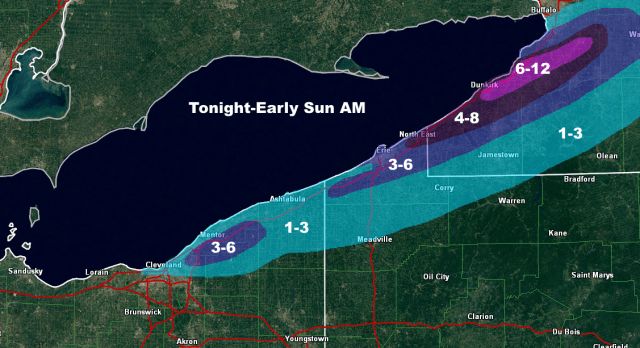
For the map and changes to it, focused the 6-12” corridor in NY where they’ll see the best potential snow tonight and also where the band is likely to affect Saturday morning. Removed the 4-8” from anywhere in NE OH as I don’t think they’ll see much if any tonight, and I’m not quite as impressed with the Saturday night snowfall there…but the higher terrain north of 322 from NE Cuyahoga into southern Lake/northern Geauga should still get a good few inches Saturday afternoon and evening. Did expand the 1” into more of northern Cuyahoga County given potential for a relatively intense band to affect that area for a time late Saturday afternoon/early evening. Reduced the area of 4-8” in Erie County PA for similar reasons as in NE OH, and mainly focused it on the NE corner where better banding will graze late tonight through early Saturday afternoon…that’s not to say that someone can’t squeak out locally more than 6” in central or western Erie County PA if a more persistent band sits there later Saturday afternoon or evening, but I don’t have enough evidence to support it in any given spot. Did bump Erie proper into 3-6” since I think they see a brief burst late tonight, get grazed Saturday morning, and get another good burst early to mid-afternoon as the trough pushes through…though that’s admittedly low confidence, and I feel more confident farther up the shore. 1-3” amounts were extended farther SE overall in NW PA and SW NY on the southern edge to give a nod to most guidance, though didn’t go as far as some models due to likely issues with banding getting too far inland.
