
First, the maps…the nice one I posted on my FB page:
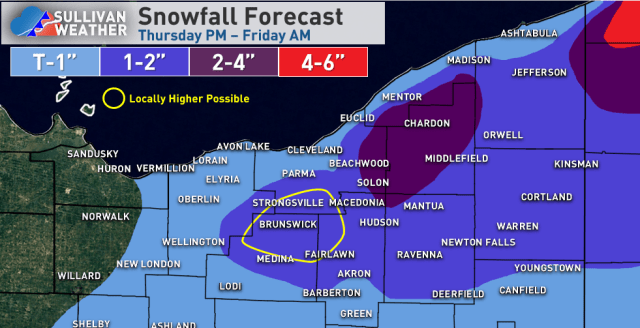
I don’t have a nicer template that includes all of NW PA, but here’s a rough sketch:

And now an overly detailed analysis…
Synoptic rain / snow late Thursday morning/afternoon…
The back edge of a budding ana-frontal rain shield will mix with and change to snow across parts of central and northern Ohio on Thursday as colder air filters in. This precip shield will be very progressive and only the back edge has a chance to briefly change to snow as the colder air catches it, so accumulations generally aren’t likely. A few of the hills in north-central Ohio could see a coating on grassy and elevated surfaces.

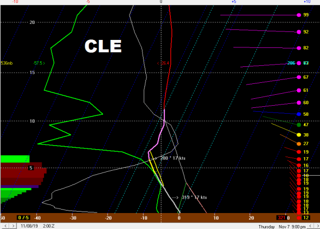
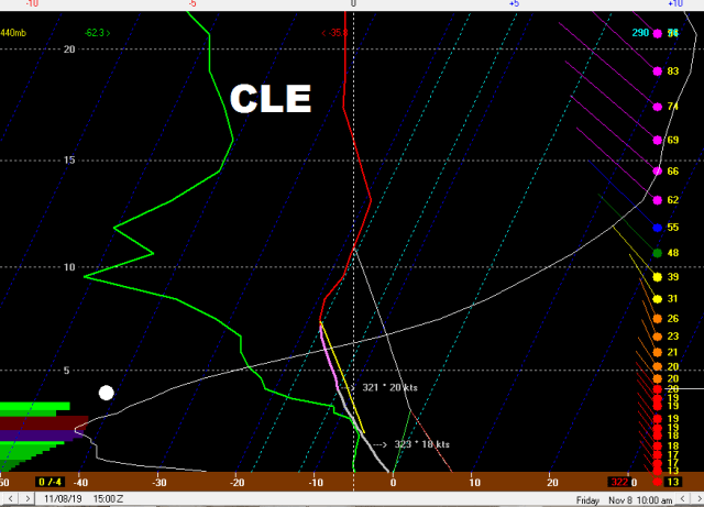
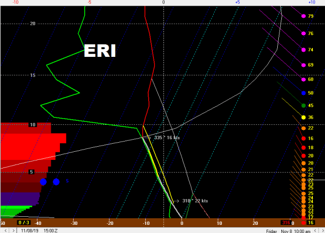
The forecast soundings for CLE and ERI actually aren’t bad with some signs of lake enhancement early in the afternoon, but it’s warm. There’s moderate lift co-located with the snow growth zone and a respectably deep layer of lake-induced instability, with northerly winds that will hit the terrain south and east of Cleveland, along with in NW PA and SW NY well. The issue is boundary layer temperatures in the lower elevations will be in the mid to upper 30s, so despite 925mb temps of -1 to -2C in this time period accumulating snow won’t occur in the low elevations (and along the lake it may stay rain). The hills south of Cleveland may see a dusting and there could be up to an inch in the highest hills of Geauga County (and perhaps a dusting as far west as the heights suburbs). The higher elevations of NW PA could see a quick, wet inch of snow with up to 2” in the higher elevations of SW NY as there’s more terrain and the precip shield is better-developed by then. Again, no daytime accumulations in the lower elevations.
Lake effect Thursday night through Friday…
As a very deep cold airmass moves over Lake Erie Thursday night into Friday extreme instability will develop with a generally northwest flow. The airmass is fairly dry and ridging starts building in from the west Friday morning making this a short-duration window for lake effect (especially in Ohio), so any decent accumulations will depend on any synoptic moisture / lift and upstream lake connections.
There will be a few hour period in the evening behind the synoptic rain / snow when there’s little synoptic help and before any upstream connections establish. There’s still moderate instability on the sounding and the winds in the lowest 5k feet are well-aligned, though the sounding is somewhat dry with a short fetch. There will likely be snow showers in the early evening in this environment, especially in the higher terrain where there’s an orographic assist, but they won’t be organized and any initial accumulations won’t be especially good.
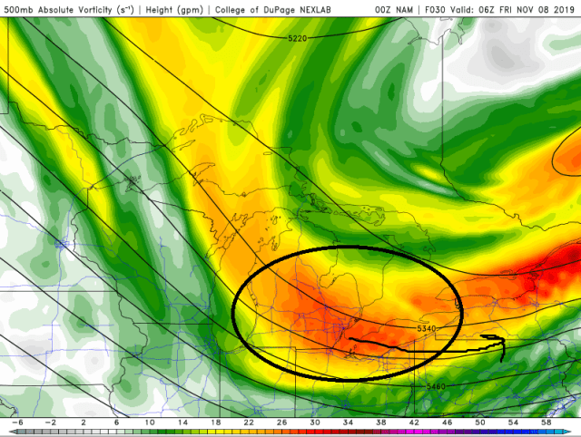
We do get a shot of synoptic help with a decent vort max that moves over the lake from late evening into the overnight, moving east into Friday morning. This adds some upward motion over the entire lake and does bring a brief shot of synoptic moisture, especially to the eastern half or so of the lake (extreme NE OH points east).

CLE’s sounding improves as this vort moves overhead, with instability becoming extreme and moisture depth up to about 7k feet. The flow is also moderate and fairly well aligned (a bit of shear but could be worse). This may support a more widespread burst of snow with the vort max, along with locally heavy snow under any upstream connections that develop into NE Ohio.
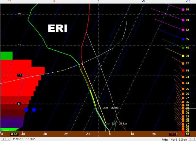
Erie’s sounding has even deeper moisture and instability, along with little shear beneath 10k feet. This would support lightning with any more intense snow bands and greater than 2” per hour snow rates…NW PA also has more terrain to work with than NE Ohio and has a stronger upstream connection to a close-by Lake Huron.

The Lake Huron connection may start fairly far west Friday evening as winds behind the developing wave of low pressure will be north, but should quickly swing into the eastern half of Erie County or even extreme SW Chautauqua County NY ahead of the vort max before going back into more of Erie County towards early Friday. The classic NW flow connection from just east of Marquette to near Traverse City to Lake Erie likely goes into the eastern suburbs of Geauga County ahead of the vort max with a slightly W of NW wind (growing up in Solon that’s where that connection goes with a 305ish flow)…it may back west a bit into early Friday behind the vort as winds veer a little more. There may be another connection from Lake Michigan west of Cleveland but is likely less organized. These will be the connections to watch for the best accumulations…how stationary they are or aren’t will be important to how high the highest localized totals are…the Lake Huron one is most interesting as it’s obviously the closest connection and also has deeper synoptic moisture than the NE Ohio ones will.
Ridging builds in quickly towards Friday morning and by 10 AM, the Cleveland sounding is pretty dry. With a lake induced EL still over 10k feet and a well-aligned flow there may be some lingering light to moderate snow showers with any left-over band that’s drifting around the metro or Snowbelt south or east of Cleveland, but it likely won’t be organized or accumulate all that much more by this point.
Erie’s soundings still remain very impressive through the morning and half decent into the evening, so the Lake Huron connection (which may briefly drift into Ashtabula County around noon Friday before swinging back east) could still rip pretty well into Friday afternoon. While the inversion heights and moisture finally start diminishing through the afternoon, there’s moderate instability and a reasonably well aligned flow through the evening, so as the winds go W and then SW Friday evening there may be one last flareup over NW PA that quickly lifts up the lakeshore but drops a little bit more snow as it goes.
Thoughts on band evolution and accumulation from the lake effect…
There’s likely an uptick late evening as the vort approaches over NE Ohio and NW PA. Upstream connections will be important and eastern Erie County PA/Chautauqua County NY, along with eastern Cuyahoga/Geauga in Ohio (and perhaps a weak one southwest of Cleveland) may be hot spots.
As the vort moves through it brings a subtle surface trough that may bring a more general burst of snow from Lorain and Medina Counties points east given extreme instability and enough moisture after midnight. With winds briefly going close to WNW ahead of it, it’s possible a more organized west-northwest to east-southeast oriented band briefly develops over Cuyahoga and Geauga Counties and then swings southwest into parts of Lorain, Medina and Summit Counties as the vort moves through and pushes the surface trough south. This may coincide with the upstream connection into the east side of Cleveland. The Lake Huron band will likely swing west into much more of Erie County PA as the vort passes overnight Thursday night into early Friday.
Behind the vort into Friday morning winds don’t move much for a few hours, so the lingering convergent band into the Secondary NE Ohio Snowbelt (parts of Lorain / Medina / Summit) may last into the morning in some form, and the upstream connection into the eastern suburbs also lasts into the early morning. The big show will be the Lake Huron band in NW PA that should go straight into the morning.
Winds do go more northerly Friday morning as the flow turns anti-cyclonic. This should end any substantial snow in the Cleveland area, though whatever is left of the bands that establish overnight may continue to drift west and produce snow showers that might drop very light amounts through Friday morning. This likely brings the Lake Huron connection briefly into Ashtabula County (and it should still be moderate to heavy) before it slowly swings back east Friday afternoon and evening across NW PA and into SW NY as winds slowly back to the W and then SW. As it swings east enough instability remains for it to drop a little more snow as it goes.
For daytime Thursday accums I’m assuming little to none except for the highest hills in northern Geauga that could see an inch…along with inland NW PA and SW NY that could see an inch or two above 1000 feet.
In NW PA I except any Lake Huron connection to have 1-2”+ per hour snow rates from late evening through Friday morning, a period of 12-15 hours. With that said, it likely is gradually moving most of the time so areas may only be under it for a couple of hours at a time. Outside of the connection, the soundings do support snow showers due to orographic lift for about the same period which will keep accums going, albeit at a slower pace, in the hills outside of the narrower heavy band. Ratios will become high away from the lake as well which will help with accumulations. There could be a quick dusting to 2” Friday afternoon or evening as the remnant band lifts back up the shore. All in all I don’t see how a lot of the higher elevations in NW PA don’t see at least 4-8” of snow, with locally higher possible if the band is at all persistent in any area. My gut says someone gets over 8”, perhaps a foot, but with the band perhaps not locking in it’s hard to explicitly forecast that. Also went 2-4” into eastern Ashtabula where there’s some terrain and where the band may drift into for a time around noon Friday.
In NE Ohio I’m going with a general inch or so away from Lake Erie for the uptick that occurs when the vort max and trough push through. The eastern suburbs into Geauga County I went 2-4”…the thought is with a possible WNW to ESE band developing for a time ahead of the vort max and a likely upstream connection that keeps a narrow band going into Friday morning, along with enough instability for 1” per hour rates under any focused bands, that over 2” is pretty likely. If any banding is more persistent someone may get more than 4”, but I think that’s very localized. The higher hills in northern Geauga may be a little northeast of the banding Thursday night into early Friday but will see some orographic lift snow showers anyways, and could see a light accumulation during the day Thursday, so over 2” seems likely there.
The other interesting spot in NE Ohio is the “Secondary Snowbelt” as the remnant convergent band may sit in that area into Friday morning behind the vort max. There isn’t a well-defined upstream connection into that area, I’m not confident they get any accumulation during the day Thursday, and ridging builds in fairly quickly so I’m not confident many areas get over 2” there, but a few may in the area I outlined.
