
Don’t have time write now for a super long write-up, but here are some quick thoughts…first the maps…
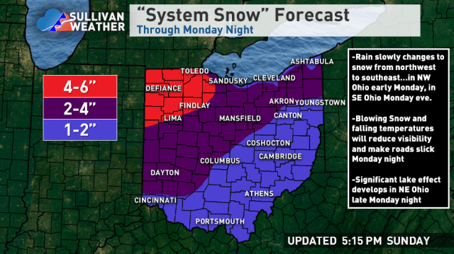
The thinking for NE Ohio is 1-2″ of synoptic snow near the lake and 2-4″ inland, highest in the hills. Temperatures marginal during the synoptic snow in the Cleveland area so hills should do better as they’ll be colder and also have some orographic lift to enhance the snow. Then the rest of the is lake effect.
Elsewhere, good setup for anafrontal snow with good right-entrance support, so everyone should get 1-2″…more in NW Ohio where they get into WAA snow Monday morning.
Parameters for the lake effect are very good, with a prolonged period of extreme instability and much better moisture than the last event. The flow is also fairly light and well aligned with decent synoptic support in a cyclonic flow under an upper-level trough. The temperature profile is ideal for high ratios with the lake effect. Question is band placement and persistence.
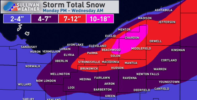
Winds swing NNE to NW late Monday night through Tuesday morning which should swing a Huron band from west of Cleveland east across the primary snowbelt, possibly getting into NW PA during the afternoon. Outside of this band, favorable parameters should allow decent orographic lift snow showers to allow for continued slower accumulations, especially in the hills. Both the NAM and RGEM show a vort max and surface trough dropping through late Tuesday afternoon or evening that may focus a more organized convergence band near Cleveland east into the snowbelt. This band may linger through most of Tuesday night as ridging builds south of the lake and turns winds more SW over land, with the snow eventually lifting NE and weakening by Wednesday morning. Any bands early Tuesday through Tuesday night can produce 1-2″ per hour rates in their core and perhaps some thundersnow.
The secondary snowbelt in southern Cuyahoga/northern Medina is odd…should get 2-4″ of synoptic snow, another 1-3 or 2-4″ through Tuesday AM as the Huron band swings east with orographic lift outside of it, and then not sure if the possible convergence band Tuesday evening/night sets up there or a little father north. Either way they should get several inches and could get 8″+ if they get the convergence band later Tuesday/Tuesday night.
For eastern Cuyahoga and Geauga, thinking 2-4″ of synoptic snow, another 2-4″ or so through Tuesday AM, perhaps up to 6″ if the Huron band is slow enough, and then likely at least several more inches where the convergence band sets up later Tuesday into Tuesday night. Either way, I think that higher terrain gets widespread double digits with well over a foot if / where the convergence band develops and is persistent.
Into NW PA, similar synoptic story, perhaps a tad more in the higher terrain, the Huron band may swing east into there and allow for beefier totals too, and even outside of that there will be some orographic lift. Think widespread 8″+ is likely in the higher terrain in southern Erie and northern Crawford Counties.
Let it snow!
