
It’s early, but some scattered thoughts based on some of the looking I’ve done into this winter…
Given a La Nina, westerly QBO, climate trends, and majority of long range guidance at this point, a warm winter has to be favored across the southern and eastern U.S. at this point, especially compared to the 1981-2010 normals which are almost obsolete at this point given how much warming we’ve continued to see this decade. I don’t think that can be ignored and is the logical starting point. Warm in the southern U.S. overall, mild up the east coast (but not as constantly warm farther north), and cold across the northwest-north-central U.S.
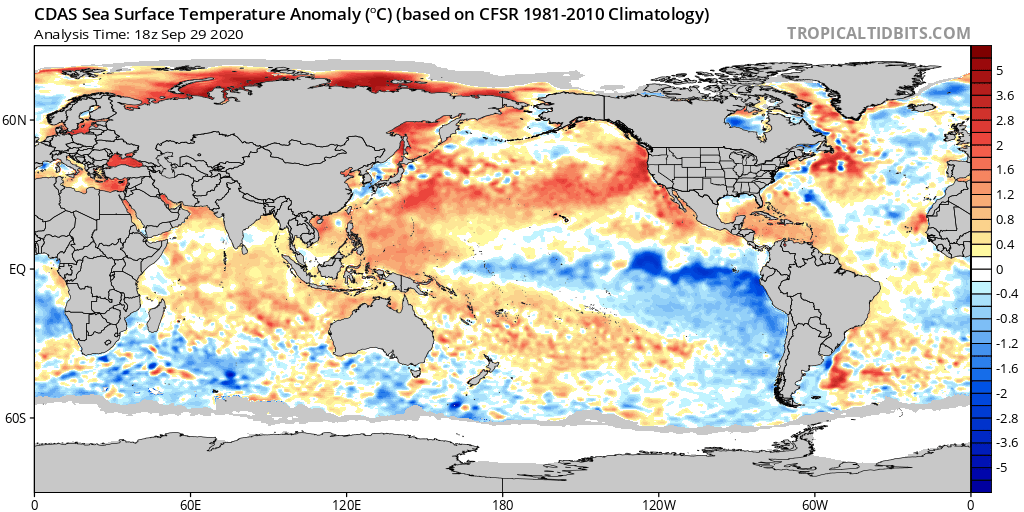

With that said, La Ninas with a westerly QBO tend to feature more ridging near Alaska and generally more cold farther southeast into the CONUS than easterly QBO La Ninas. This has been pointed out by many people (who are generally smarter than me) over the last decade or so. Also, this La Nina is currently centered over the eastern Pacific, which tends to open the door for a colder outcome compared to La Ninas that are more basin-wide. An extraordinarily warm and large western Pacific warm pool and negative IOD may encourage an active MJO this winter over the western Pacific, and the persistent western Indian Ocean standing wave that severely limited Pacific forcing last winter through this summer may finally be weakening (not 100% sold on that yet, but there appears to at least be some more variability in the near future). Warm water near the Maritimes can be dangerous, as sub-seasonal forcing in that area is warm in the winter for us (and remember, I think the baseline here is a mild to warm winter across the southern and eastern U.S.), but the warm West Pac may encourage an active enough MJO to give us windows of opportunity. While the PDO is rather close to neutral, waters are currently quite warm over the NE Pacific…we’ll see if that changes in October though with more storminess in that area. The warm waters over the NE Pacific and extensive western U.S. drought are a result of a persistently ridgy pattern there this summer…does that continue into the cold season, or will outside forces coerce a change?
So, off the cuff, there’s an urge (especially after last winter) to forecast an all-out torch-fest. There are several reasons for optimism…and the pattern in the short-term, with an amped Pacific jet resulting in an amped west coast ridge and hints of Scandinavian blocking, would be beneficial both short and long-term if it ends up being a semi-regular occurrence over the next few months, as it is not warm as it occurs and also isn’t favorable for the stratospheric polar vortex strengthening uncontrollably. Is this just a brief mid-fall blip, or is it a sign of things to come? Remember, we had a hell of a blip / head fake last November and early December…I bit on it myself.
Looking at some analogs, there are some very warm winters that show up in here, actually a couple of block-busters, and a few OK years. The first set focuses on west QBO La Ninas that reasonably match in at least 2 of the following 4 areas: Indian Ocean (negative IOD), east based La Nina, warm West Pac, and Warm NE Pacific. As a note, 1973-74 would have made this set, but it was an exceptionally strong La Nina so I chose to exclude it.
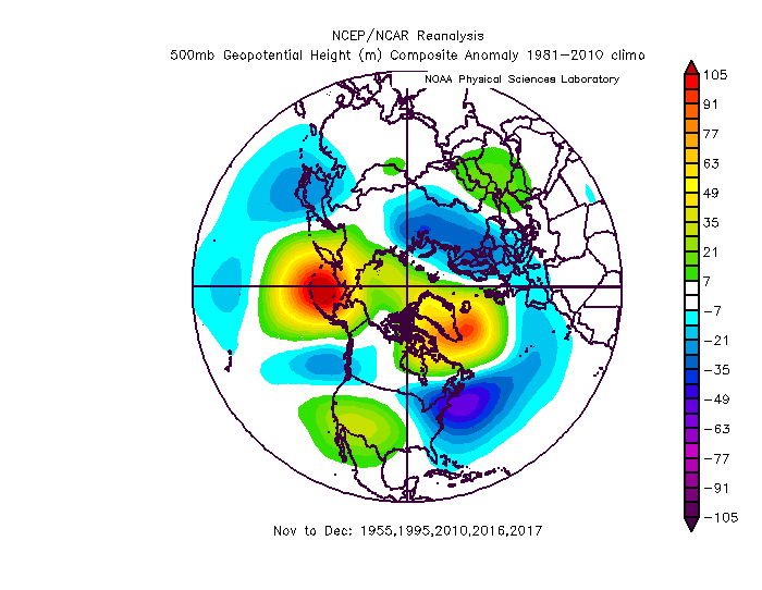
The DJF 500mb composite and temperature/precip anomalies:

Temps with 1981-2010 climo:
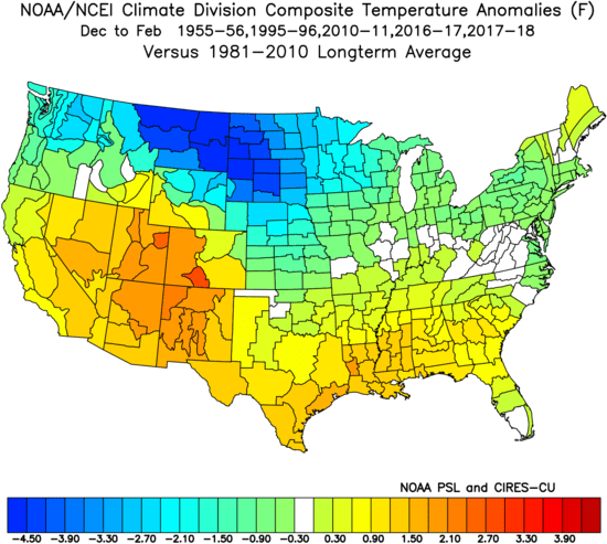
Went back and forth on which climo period is best to use given 55-56 was in a noticably cooler climo, so for completeness here is the same map with a 1951-2010 climo:

Precip:

The bulk of the cold in these winters is frontloaded, with November and December both colder than normal for much of the northern and eastern U.S:
January is a more mixed month, with February featuring an incredible warm signal over most of the southern and eastern U.S. March is more mixed and leans cooler over the NE.
A second set of years I played with focuses less on SST distribution and more on QBO and early-mid fall patterns and tropical forcing. There were few that matched all areas (though, 95-96, 10-11 and 17-18 were at least reasonable in all fields analyzed, even if not perfect). They show a similar (but slightly muted) signal overall for the whole winter, and still show a preference for any cold being more front-loaded with a strong warm signal for February:

(because all but 1 analog are after 1980 and this is a larger set, will not include the longer climo base period map…but it would make it appear warmer compared to the climo as it did to the other set)


Some overall takeaways…yes, a mild winter is favored (temperature wise) over the southern and eastern U.S., but there are ways to get cold air at times. Analogs are not as warm as you’d think (a disclaimer about ENSO-based analogs generally being too cold the last few winters is needed here, though last winter was exceptional due to the record wind speeds and cold observed with the stratospheric PV between January and March), and there is a strong signal for early cold and snow potential over the Great Lakes, Ohio Valley, Northeast and Mid-Atlantic among the analogs. Given the global pattern setting up heading into early October, I think the idea of an early blocky / cold pattern is there if we can get sub-seasonal forcing into the western Pacific between late-October and some point in November. However, for as surprisingly chilly as the analogs may be early, they’re more mixed in January and are exceptionally warm overall for February (and mixed / leaning cool for March in the Northeast), underscoring this type of winter does have “warm risks” that may be substantial. We’ll probably have a better idea on how the start of the winter will go in a few weeks when we see what actually happens heading through October.
So, I’m not overly pessimistic or optimistic at this point. I am curious though. 2017-18 is a decent analog (that winter held onto a +QBO below 40-50 mb all the way through), and I can see how an overall similar evolution to that winter plays out (though quite possibly without the SSW and hence, a more typical March).
