
The weather models are running just as quickly and as often as they can. Outputting nothing. Outputting snow. Outputting rain. Back and forth. Life and death. Snip snap! The fingers are typing and posting on Twitter even faster, if that’s even possible. But yes, actually, there are four “systems” that may produce snow on the East Coast next week, and one of them looks rather delectable, especially from the interior / northern Mid Atlantic into New England.
A quick note on how this pattern is coming to be…


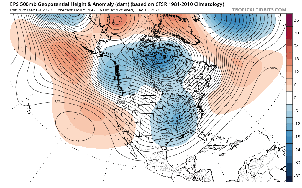
The combination of a negative East Asian Mountain Torque event (lower pressure east of the mountains) and piece of the tropospheric polar vortex dropping into Asia is encouraging a somewhat retracted Pacific jet stream (after it was quite strong / extended to end November and start December) and wave breaks over the northern Pacific. This is allowing heights to rise in the northern Pacific, dropping the EPO and WPO. This is greatly increasing polar air in North America after it lacked to start December and prevented last weekend’s storm from being snowier. And by snowier, I mean producing more than 0 snowflakes in New Jersey.
Tropical forcing is centered near 120E right now, registering as a phase 5 MJO, projected to move into phase 6 next week:
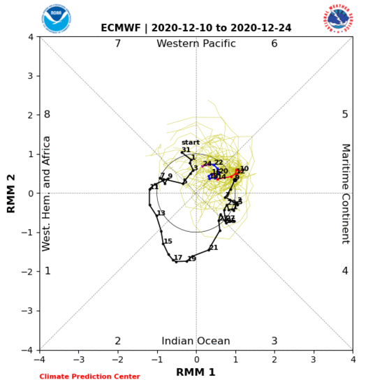
The RMM plots have had a hard time tracking this current MJO as it’s constructively interfering with lower frequency forcing near 120-150E. However, it seems there’s still a coherent MJO in there that’s currently in phase 5 and may get into phase 6 or 7 next week. You can see how the lift really intensified over the Indian Ocean last month as the MJO approached the low frequency forcing near Indonesia…and how it seems the MJO is now emerging on the other side towards the western Pacific:
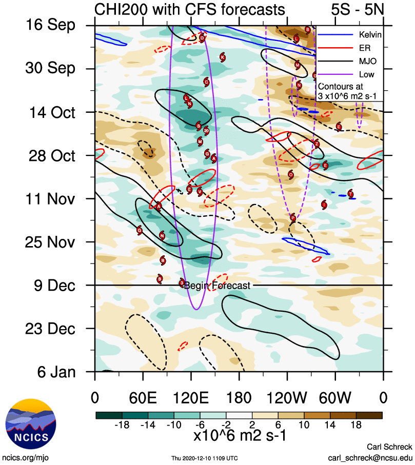
The CFS (above), EPS and GEFS all have some uptick in 200mb upward motion as far east as the Dateline over the next 5-7 days. A phase 5-7 MJO in mid-December strongly suggests blocking in both he EPO and NAO domain:
This period of potential blocking, aided strongly by tropical forcing along with a recent +East Asian Mountain Torque that really beefed up the sub-tropical jet, has been talked about many (including myself) since November. I personally was not as sold on legitimate NAO blocking, but that does seem likely to occur this weekend through next week.

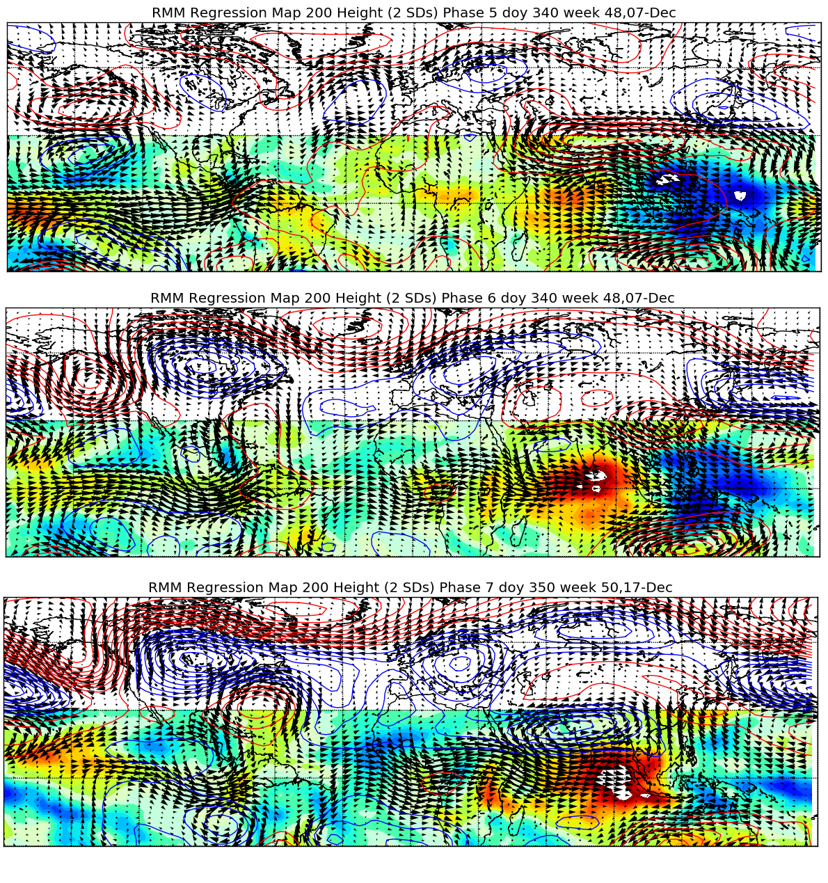
It’s quite possible that a disruption to the stratospheric polar vortex, causing it to get split in the lower stratosphere for a time, with a lobe dropping into Asia and another into North America, with ridging / weaker flow in between over the north Pacific and north Atlantic, is encouraging this tropospheric blocking.

One can definitely see on the 3D vortex plot from stratobserve.com how the tropospheric and stratospheric blocking across the north Atlantic may be somewhat coupled, and also how the lobe of the tropospheric polar vortex dropping into North America is tied to the stratospheric vortex as well. This activity within the polar vortex is complimenting what the tropical forcing suggests quite nicely…and this disruption is likely tied to a recent strong MJO progression across the Indian Ocean and strong East Asian Mountain Torque event.
I guess this is a long way of saying high latitude blocking, including in the NAO domain (2020 baby!) is quite well-supported next week. Though, do note that phase 5-6 tropical forcing in late December supports troughing over western North America and a Southeast Ridge, and as the MJO eventually weakens and the low frequency forcing takes over later in the month troughing very well may try to slide west. But let’s not skip to that, let’s break down next week’s potentials…
Monday:
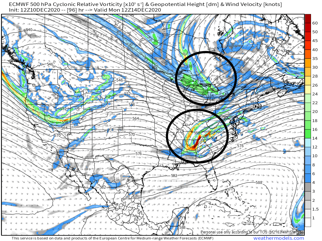
Dig polar jet, dig! Ah that’s been the rub against the Monday – Tuesday threat, the lack of ridging out west would keep the polar jet too bottled up to get enough stream interaction for a storm to deepen and come up the East Coast. Is there hope on that front?

There is quite a bit of blocking over the Arctic and north Atlantic. The polar vortex is over Hudson Bay! There isn’t a 50/50 low yet, but the Atlantic side is not inhospitable. The Pacific side is a little more…eh? If ridging off the West Coast is a bit stouter, or if there is just a bit more “traffic” over the Atlantic, perhaps the northern piece can dig a little more.

The trend to raise heights a bit over the Davis Strait and nudge the PV a bit west…and trend on the West Coast to have a little more ridging between shortwaves…may just force the northern stream to dig a bit more. That would result in a better chance at a phase and a more robust coastal. The rub here is there’s no 50/50 low yet (or “traffic”), so a stronger storm would try to cut a bit more. So, I-95 would require a perfectly timed phase for legitimate snow, but inland is in a better position if we trend towards a better phase.
Both the EPS and GEFS runs at 18z like this slightly more phased idea for whatever reason…seems it’s the northern Mid-Atlantic most likely to get snow, especially NW of I-95, with some potential this gets into NY or New England if we see more wholesale changes to slow down / dig the polar jet shortwave more.


There are a number of EPS members that are stronger than the mean, though most are northwest of the mean, and the strongest ones are well northwest of the mean. This is evident on both the spread (all to the north/northwest of the mean) and map of the member low locations:


My verdict on this one is to watch for the polar / northern jet shortwave to dig more. If it can, it opens the door for more snow, but may also shift that snow NW of I-95 pretty quickly if we aren’t careful.
Wednesday – Thursday:

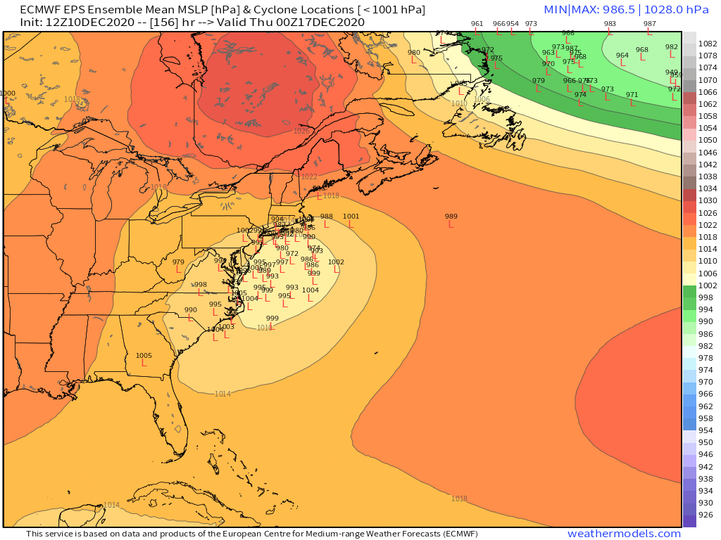
This is currently the big-ticket item generating most of the images getting posted on weather social media. A primary low moves towards the Great Lakes, as it runs into confluence over southeast Canada the energy gets shunted east and sparks a coastal (Miller B) off the northern Mid Atlantic or New England coast. With reasonably cold air in place to the north, this may produce a good amount of snow for someone…


The pattern is pretty delectable on the Atlantic side. A strong -AO, -NAO, and 50/50 low. The -NAO and 50/50 low coax that strong confluence over southeast Canada, supporting a surface high pressure that forces the Miller B coastal to form. The tropospheric PV and 50/50 low, which was a lobe that broke off from the PV, mean there’s actual cold air available to tap, unlike last weekend when a robust Nor’easter produced more rain than snow. The Pacific pattern isn’t ideal…the ridge axis is a little southwest of preferable and the polar vortex is a little west/northwest than an ideal location. So, this would likely act to limit any threat in the Southeast and lower Mid-Atlantic. But, the Atlantic blocking and cold air over Canada being so robust would pretty much guarantee snow from much of PA and northern NJ into NY and New England, assuming there’s a storm.
The trends on the EPS over the last few days for this time period are remarkable. The NAO has trending much more negative, with that -NAO also trending more west based, with the strongest anomalies over the Davis Strait! There has also been a trend for a much stronger and more optimally placed 50/50 low. These trends are a result of trends with the Monday system for a more amped northern stream and potentially stronger coastal. The AO blocking has also trended stronger, and perhaps also as important, ridging over the Aleutians has been trending towards mainland Alaska. One more trend in that direction and all of a sudden the PV is nudged a little to the east, which would be a better spot.
Right now, it’s quite a good set-up north of the Mason-Dixon line, especially inland, but if the Pacific side trends a bit better could become something interesting in the lower Mid Atlantic or Southeast.


These are impressive ensemble mean snow swaths for over a week out for the EPS and GEFS this afternoon / evening. The greatest signal is from eastern PA through NYC and Boston, initially favored NW of I-95 but then right along it. There is considerable spread on both sides through. Also note how there is some potential for snow with the primary low over the Ohio Valley too on the other side of the Appalachians.
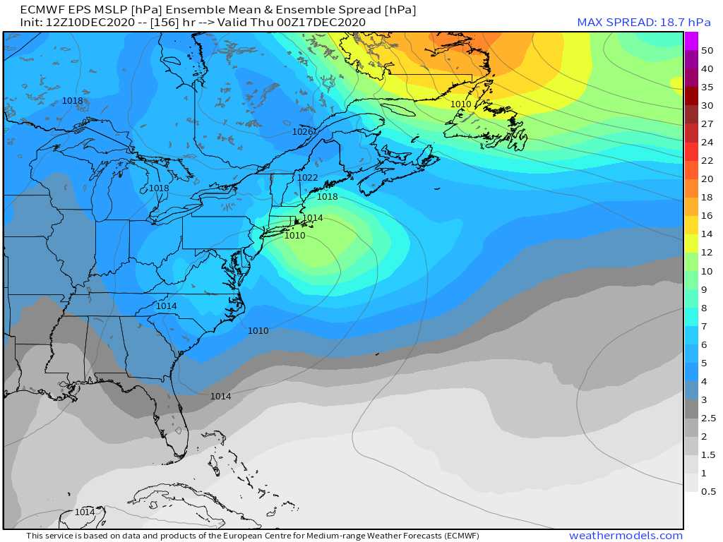
While there’s great agreement on a general low track off the East Coast next Wednesday – Thursday, there is still a good bit of spread in both track and speed, and intensity at all points. This likely has a lot to do with how well this shortwave interacts with the polar stream, and how strong the Monday system becomes, since it turns into the 50/50 low.
My thoughts on this one are that the Atlantic side is stellar, and the shortwave ejected east across the country is strong. There should be a decent Nor’easter with snow for at least part of the Northeast or Mid-Atlantic. If the Pacific side isn’t as ideal, with the PV centered a bit to the west and the ridge axis southwest of what’s preferable, though some improvements may still occur there based on current trends. These improvements could really up the ante for snow somewhere if they occur.
Otherwise, how the Monday system pans out will also impact this second threat. A stronger Monday system may force this system farther south, turning it into more of a Mid Atlantic problem and perhaps limiting how far north any snow can get. A weaker Monday system could weaken the confluence over Canada enough to allow the primary to cut a bit more, which would limit the threat on the southern extent by pumping in more warm air before the coastal tries to form.
A storm seems likely for someone, but a lot can change where and exactly how much. Wow, I know, I’m such a prophet.
Next Friday and Sunday:
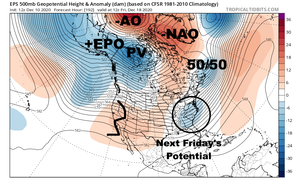

The Atlantic pattern remains decent through next weekend and the AO stays negative…however, the EPO rises and the PNA tries dipping, which will try to flood the CONUS with Pacific air and make it harder to see enough northern stream interaction for a phase or good winter storm. How the Wednesday-Thursday storm plays out will also impact the pattern for Friday’s storm, and Friday’s storm will have an impact on the Sunday storm. See a pattern? This is fun.
If the Pacific side holds onto a more neutral pattern just a bit longer that could really make one of these a more plausible storm. Is that possible? My gosh these questions are why I should be sober when I write. I ask fewer weenie questions while sober.

After the ongoing negative East Asian Mountain Torque, we’ll have a positive torque develop much of next week into the following weekend. This will act to extend the Pacific jet again. There will be a brief window next week where this may encourage a stronger low near the Okhotsk Sea (NW Pacific). As some of this momentum gets dispersed into the sub-tropical jet over the East Pacific, this may combine with the Okhotsk low to try to wedge a ridge between that low and the PV edging into the EPO domain from western Canada. That’s a long way of saying it’s possible it takes the EPO a bit longer to rise than the current ensembles, though it seems inevitable to eventually happen.
My impression is that unless the Wednesday – Thursday storm falls apart that it will make the Friday system unlikely to happen. Or, it will shove it so far south it’s mainly a Mid Atlantic or even Southeast event. The hostile Pacific pattern may limit the potential on next Sunday, though if there is enough polar influence it may again threaten the Mid Atlantic or southern New England.
The takeaways to all of this are that a lot supports high-latitude blocking next week, and we have a few systems that can take advantage. The Wednesday – Thursday is the most likely to be a major storm for the greatest number of people as Monday, Friday, and next Sunday’s threats all need a bit of work. But all are close enough not to rule any out. That’s to say, let the model watching continue…
