
This will be article 1 or 4 discussing moderate to in some cases extreme snowfall that has occurred over Northern Ohio in April. Because my memory and in some cases archives of these events become quite fuzzy the farther back we go, I will be examining for decently recent events, from 2005 onward, of heavy April Snowfall.
Synopsis/Observations:
The winter of 2004-2005 was already a notable one across much of Northeastern Ohio, with Cleveland Hopkins International Airport, henceforth CLE, the flagship official climate station for the Cleveland metro, approaching record snowfall for a single winter. April snowfall does occur from time to time across Northeastern Ohio, and every now and then more than just a light dusting does fall, especially in the Snowbelt. However, with CLE only averaging 3.3” of snow during the month of April (using 1981-2010 averages), one is never able to firmly count on April to deliver significant snowfall, even after a winter like 2004-2005 during which the atmosphere seems to produce excessive amounts of snow ad-nauseam across Northern Ohio.
However, the atmosphere would put to doubt whether or not 2004-2005 would become the snowiest winter on record in Cleveland during the first three days of April:
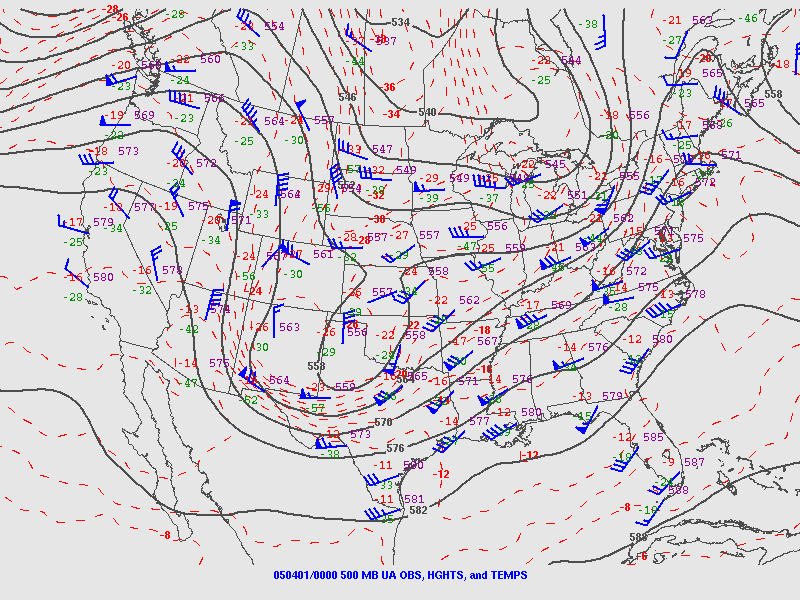
Although wavelengths tend to shorten in the spring, similar principles still apply. As we look at the 500mb chart, representing the weather pattern at 18,000 feet on 4/1/05, it is evident that there is ample western US ridging for trough amplification over the central US. This, combined with higher heights than normal over eastern Canada and Greenland, which aren’t readily visible on this map, ensured that the trough would not be in any hurry to move east and allow mild air to return to the Midwest, Great Lakes, and Ohio Valley in early April of 2005.
A shortwave seen rounding the base of the trough on April 1 sparked off a surface cyclone over Texas that tracked east-northeast during the first and second of the month towards the Tennessee Valley:
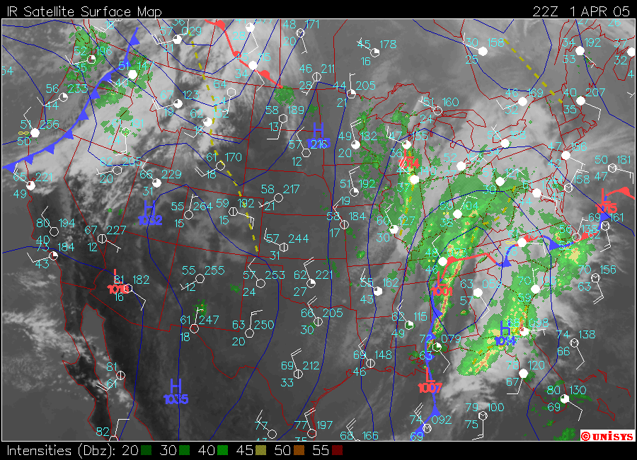
A look at the surface map for the evening of April 1 shows our surface cyclone tracking well south of the region. However, due to the fact that it’s April, there was not much cold air to the north of the system yet, meaning much of the precipitation falling over the Great Lakes and eastern Midwest was rain. So, we would have to wait for colder air to arrive for the snow to begin.
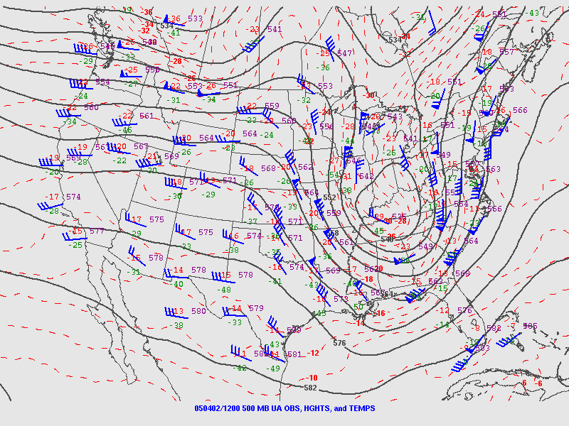
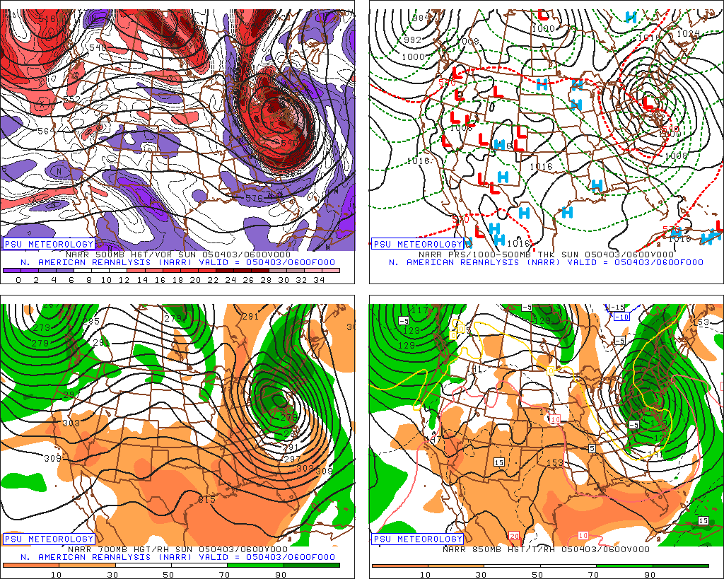
The wait would end as we trudged towards April 2, as the 500mb trough (shown above the morning of the 2nd) would close off, allowing dynamical cooling to slowly cool the lower levels of the atmosphere over the northern Ohio Valley and lower Great Lakes. Some cooler air was also pulled down from Canada during this process.
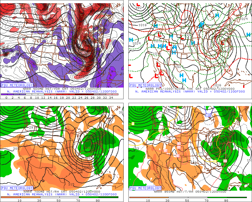
Another look at the morning of April 2nd off of the Penn State e-wall shows the freezing line at 850mb, or about 5000 feet above mean sea level, plunging into the Deep South. In April this usually does not correlate well with the rain/snow line; at the elevation of northern Ohio (600 feet at the Lake Erie shoreline to over 1100 feet in some of the hills in far Northeastern Ohio) 850mb temperatures usually need to dip below -5C/23F to get accumulating snow in April. Although the -5C isotherm is not near Ohio yet on this image, the air was cold enough and precipitation heavy enough for snowfall to begin reaching the ground over Northwestern Ohio in the few hours proceeding this image. CLE began mixing with snow around 4am on the 2nd, changed to snow by 4:30am, and remarkably reported snow in every observation for the rest of the day, with visibilities at times dropping to ¼ of a mile, signifying heavy snow.
Once you got to the east side, the track of the 850mb low (shown in the bottom right panel) held back the rain snow line through a good chunk of the day. At Ashtabula County Regional Airport (henceforth HZY) the transition to snow did not occur until 1:25pm on April 2, and the air temperature did not drop below 35 degrees until after midnight, holding accumulations in check well east of Cleveland until after dark on the 2nd.
Either way, snow was ongoing and accumulating moderately to heavily at times by late April 2 and continued right on into April 3 before tapering in the morning from west to east.
The snow on the west side, including at CLE, shutoff soon after 12am on the 3rd as the event become more and more lake-effect driven thanks to the synoptic precipitation with the surface low pressure beginning to pull off to the east. However, on the east side, snow continued through much of the morning on the third:
Note how from Cleveland west, the mid-levels of the atmosphere are drying and high pressure at the surface is beginning to move in. East of Cleveland, the atmosphere remained moist and the western edges of a cyclonic flow helped insure large scale lift/convergence over the region. With 850mb temps dropping to near -5C in this timeframe, there was just enough instability added from Lake Erie (water temps approaching 40F/+5C (educated guess)) for snowfall amounts to be enhanced east of Cleveland. This resulted in many hours of moderate to heavy snow east of Cleveland.
At HZY, moderate to heavy snow occurred in consecutive observations from 4:53am on April 3 through 1:53pm on April 3, meaning visibilities were reduced to less than ¾ of a mile. There were 5 hourly observations (non-consecutive) in this timeframe during which heavy snow was reported, meaning visibilities were reduced to less than ¼ of a mile for a considerable portion of the event.
Despite all of the snow, CLE never dropped below 33F during the event, which occurred during the afternoon and evening hours on the 2nd, and HZY, stunningly, never dropped below 33.8F during an hourly or intra-hourly observation, and was generally sitting at 34-36 degrees during the heaviest snowfall. CLE rebounded to 53 by late afternoon on the 3rd and HZY rebounded to 46 by late afternoon on the 3rd, despite recording “heavy snow” as late as 12:53PM and “snow” (with a visibility of half a mile) as late as 1:53PM. CLE reported 6.8” of snow with the event. Ashtabula (not formally specified as HZY in the official release) recorded 16.8” of snow.
Four other regional airports in Northern Ohio were affected in at least a moderate fashion by this early April snowstorm in 2005:
Mansfield (MFD):
Changed to snow at 7:30am on 4/2/05, and reported snow in every observation through 11:11PM when the snow summarily ended. Being farther inland from the slightly warmer waters of Lake Erie, MFD was able to cool to 32-33F during the majority of the heaviest snowfall. The visibility at MFD was held at or below 1 mile from 7:52am through 5:10PM on 4/2/05, with the visibility held at or below ¼ of a mile from 10:22am through 1:52pm, signifying over three hours of consistent heavy snowfall. Visibilities again were held to ½ to 1 mile from 6:45pm through 9:52pm, signifying another three plus hour period of heavier snowfall. MFD reported 8.0” of snowfall with the event.
Akron/Canton (CAK):
Rain did not completely change to snow until 1:51pm on 4/2/05 at CAK after two hours of rain/snow mixed. After the rain fully changed over to snow, snow was reported in every single observation through 5:50am on 4/3/05 (with another brief period of light snow around 8:00am on 4/3/05). Being inland from Lake Erie also helped temps at CAK sit at 32-34 degrees during the heaviest snowfall, which is conducive for accumulation once snow comes down at a heavier clip. At CAK, the visibility was held at or below 1 more from 2:04pm on 4/2/05 through at least 1:51am on 4/3/05 (although, it should be noted there were no observations between 1:51am and 4:50am on 4/3/05, potentially due to a power outage). Visibilities at CAK never dropped below ½ of a mile, however with many hours of moderate snowfall and temperatures at or just above freezing, some accumulation did occur. CAK reported 5.1” of snowfall with the event.
Youngstown (YNG):
Changeover to snow occurred by 1:51pm on 4/2/05, with snow reported in every observation through 1:51pm on 4/3/05, meaning YNG received 24 consecutive hours of snowfall in April. Being inland from Lake Erie also helped YNG hover between 30-33 degrees during the majority of the snowfall, allowing for snow accumulations to occur. At YNG the visibility had dipped below 1 mile by 6:38pm on 4/2/05 and did not rise above 1 mile again until 1:43pm on 4/3/05, representing over 19 consecutive hours of “high-end light” or moderate/heavy snowfall. In that timeframe YNG reported half mile or lower visibility from 5:51am on 4/3/05 through 12:51pm on 4/3/05 (7 hours) and reported quarter mile or lower visibility from 6:04am through 10:51am on 4/3/05 (just short of 5 hours). Through all of that, YNG reported 8.5” of snowfall.
Lorain/Elyria (LPR):
LPR changed over to snow by 3:51am on 4/2/05, and reported snow in every observation except for one through 7:53pm on 4/2/05, representing 16 hours of essentially persistent snowfall at LPR. Although LPR did not have any notably long periods of visibilities at or below one mile, there were a couple hours of moderate snow in the morning and again after noon, with visibilities bottoming out at ¼ of a mile at 2:53pm on 4/2/05. Temperatures generally sat between 33-35F during the snowfall at LPR. No official tally from LPR was available from what I could find, however, based on nearby snow totals and observations at the airport, it appears as though 4-6” of snow reasonably fell on 4/2/05 at LPR.
Societal Impacts:
Leaves were just beginning to open up across Northeastern Ohio when this snow fell, however winds gusting over 40MPH and the heavy nature of the snow (note, surface temperatures generally sat above freezing or fell just below it during the snow) allowed for widespread tree and power line damage from eastern Cuyahoga, northeastern Summit and northern Portage Counties points eastward through Geauga and Ashtabula Counties. Tens of thousands were left without power. Travel due to downed trees/wires and heavy snow accumulation on roadways was nearly impossible on the 3rd across much of Geauga and Ashtabula Counties, and was hampered at times well west of there late on the 2nd into the morning of the 3rd where lighter, but still significant, snowfall totals were observed.
Comments:
The fact the Toledo never reported snowfall with the event and Findlay only reported a few hours of light snow or rain/snow mixed illustrates how much dynamical cooling thanks to the deep/closed 500mb low helped change rain to snow, and also shows how heavier precipitation rates helped the changeover as well, as Toledo and Findlay never got into heavy precipitation on 4/2/05. The slow movement of the 500mb trough/low allowed the deformation snows to sit over north-central and northeast Ohio for many hours, and added moisture/conditional instability from Lake Erie allowed the Snowbelt communities to see the heaviest snowfall totals.
2-day radar loop of event (times are in UTC, subtract 4 hours from time shown on radar to obtain EDT equivalent):
https://www.youtube.com/watch?v=6MqWPptZ-aM
Snowfall total highlights:
Ashtabula County:
22.0” in Conneaut along I-90
23.0” 2 miles SE of Pierpont
16.9” in Geneva
16.8” in Ashtabula
Cuyahoga County:
9.0” in Shaker Heights and North Royalton
6.8” at CLE
Geauga County:
24.8” 3 miles south of Thompson
22.9” 5 miles southwest of Thompson
20.5” in Hamden Township
17.0” in Chardon
Lorain County:
5.6” in North Ridgeville
Mahoning County:
8.0” in Austintown
Medina County:
5.8” in Hinckley
Portage County:
11.5” in Hiram Rapids
5.2” in Kent
Summit County:
5.1” at CAK
Trumbull County:
8.5” at YNG
*Colt Station in NW PA reported 29.0” of snowfall with the event.
I have the complete list of snowfall totals saved to my computer. If you would like a full copy of snow reports let me know.
Images 1-3 were obtained from this website:
http://locust.mmm.ucar.edu/case-selection/
Radar loop was also constructed using data obtained from that website.
Images 4-5 were obtained from this website:
http://www.meteo.psu.edu/~fxg1/NARR/2005.html
The archived PNS containing snowfall reports used above was obtained from this website:
http://has.ncdc.noaa.gov/pls/plhas/HAS.FileAppSelect?datasetname=9957ANX
The hourly observation data sited above for CLE, CAK, MFD, CAK, LPR and YNG were obtained through Wunderground.com
