So it’s getting to be that time of year where the days are just a little shorter…the high temperatures just a little cooler…and school getting back in session. Winter weather is still months away from most US locations…but it is starting to get to the point where we can look at some trends around the globe in both the atmosphere and oceans and try to take a stab at what this winter will bring. Here is a look at my final winter outlook from last year:
https://ohwxramblings.wordpress.com/2012/10/18/2012-2013-winter-outlook/
Pacific/Indian Ocean Water Temperatures:
Despite thoughts in the spring and even early summer than an El Nino may develop, the equatorial Pacific as of mid-August is running a bit cooler than normal, especially closer to South America. The most recent two winters have featured a warm Indian Ocean…as of mid-August however, the Indian Ocean has cooled to near or a bit cooler than normal. We are in the early half of a multi-decadal “negative” “Pacific Decadal Oscillation” (henceforth PDO), however this summer the PDO has tilted closer to neutral. We’ll discuss what this all means below:
El Nino-Southern Oscillation (from now on, ENSO):
The state of the ENSO describes sea surface temperatures in the equatorial Pacific, with a “El Nino” occurring when these waters are warmer than normal and a “La Nina” occurring when these waters are cooler than normal. The winter of 2011-12 was a strong La Nina. Last winter was a borderline cool neutral/weak La Nina. The question is, will the current cooler than normal waters in the equatorial Pacific lead to another winter La Nina?
A “La Nina” officially occurs when the ENSO regions (shown above) average 0.5 degrees Fahrenheit or more below normal for three or more consecutive three month periods. As seen above on the breakdown of ENSO region temperatures through early August, we aren’t there yet. However, all of the ENSO regions have either cooled or held steady temperature wise since the beginning of June.
Looking just below the sea surface in the equatorial Pacific Ocean…one can see that the expanse of warm anomalies that had developed sub-surface to begin the summer have generally subsided. However, cold anomalies have had trouble taking hold outside of the far eastern Pacific.
The Southern Oscillation Index, or SOI, is a measure of the pressure difference between western South America and eastern Australia. When the index is positive (as it has been on average for quite some time of late) it indicates that the pressures are higher over South America, which favors stronger than normal trade winds over the Pacific and an upwelling of cooler sub-surface waters. When the index is negative (which it was on Friday) the opposite occurs. A positive SOI favors the development/persistence of La Nina and vice/versa. The long term SOI this summer favors the development of La Nina, however recent values suggest otherwise. Updated SOI data can always be found at this link:
http://www.longpaddock.qld.gov.au/seasonalclimateoutlook/southernoscillationindex/
Current trends all lean fairly strongly against El Nino development, however there hasn’t been a strong push towards La Nina like conditions recently either. The very cold eastern Pacific does point towards a La Nina and an average of the ENSO regions is certainly tilted towards La Nina but isn’t quite there yet. Given only a modest tilt of the aforementioned factors towards La Nina development, I think that if a La Nina develops this winter it will be weak…if not, the ENSO will be “neutral” but certainly not warm.
Pacific Decadal Oscillation (PDO):
As mentioned above the PDO is in a multi-decadal “negative” phase since the late 1990’s…and has been especially negative since 2008. For reference, here are what the two phases of the PDO look like, courtesy of the University of Washington (warm/positive on left, cold/negative on right):
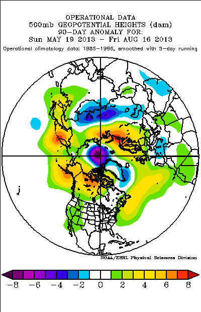
As seen at the top of the article, despite the long term cold PDO, the waters off the west coast of North America are rather warm at the present, which gives the current PDO a more neutral look. This is likely due to abnormally strong ridging and quiet weather over Alaska and western North America since mid-May, which has contributed to the rather rainy and at times cool summer over the central US:
The forecast models and expected placement of tropical convection this week suggest that troughing is likely to occur over northwestern North America over at least the next two weeks…and into September. If this occurs, those warmer waters will quickly begin to cool and the PDO will take on a more convincingly negative look. I expect this to occur and feel fairly confident in a negative PDO winter.
Indian Ocean:
The Indian Ocean Dipole (or IOD) is a measure of the east to west temperature gradient across the Indian Ocean. A negative IOD, as we are in currently, is indicative of warmer waters near Australia and cooler waters farther west near Africa. This summer’s current cool waters over the western Indian Ocean have at times created enough of a temperature difference across the ocean to meet the threshold of a “cold” dipole event. This is in stark contrast to the abnormally warmer waters over the western portions of the basin over the last two summers, which at times were warm enough to meet the threshold of a warm dipole event.
http://www.jamstec.go.jp/frcgc/research/d1/iod/DATA/dmi_HadISST.txt
Based on this data set provided by Jamstec, I have found 9 cases since 1959 that featured a cool Indian Ocean Dipole over the course of December, January and February that may be similar to what we will see this winter. In general I looked for an average DJF index of -0.3 to -0.8, and threw out a few cases that matched this based on the index not being anywhere near this year’s negative index. Here is a look at where convection was more/less active than normal in the tropics during the years I selected during the DJF timeframe:
Note how unlike last winter, convection is generally less active than normal over the Indian Ocean and more active east of Australia and even east of the dateline. The composite SST anomalies of these winters shows a cool/neutral ENSO, however a couple of these winters were El Nino’s that may have skewed up precipitation amounts some east of the Dateline. A key here is however that we likely won’t see persistent convection as far west of the Dateline as we did last winter, which resulted in an abnormally strong Asian/Pacific jet and rather persistent ridging well off the western US coast. Below is a look at the SST in the winters looked at above:
Summing up the Pacific/Indian Ocean:
I expect a cool neutral ENSO this winter, with some chance at a weak La Nina. I expect the waters off the west coast of North America to cool, giving the PDO the more negative look we have been accustomed to in recent years. I expect the Indian Ocean Dipole to remain cool and perhaps become a true cold dipole event. In general one would expect convection to be most active from Australia to the dateline based on this SST configuration, putting ridging near/ just off the west coast of the US to the northeast of the convection. This is in contrast to last winter when ridging was strongest south of Alaska due to a persistently strong Asian/Pacific jet, especially early in the winter.
I have thumbed through DJF reanalysis SST’s over the Indian Ocean/Pacific since 1949, and found 3 years (coincidentally all since 2000) that reasonably match what I expect out of this winter’s SSTs:
The mean 500mb pattern in those winters is close to what I described above…with ridging persisting a bit off the western North America coast, a bit east than where it was centered last winter:
With cool waters in the equatorial Pacific and ridging just off the west coast of the US, one would expect a weaker than normal sub-tropical jet promoting drier and warmer conditions than normal across the southern US this week…especially the southeastern US. With a possible southeast ridge and cooler than normal air east of the eastern Pacific ridge over the Rockies and central US…conditions could be rather wet across portions of the Mississippi Valley if the Atlantic cooperates…speaking of which:
Atlantic Ocean:
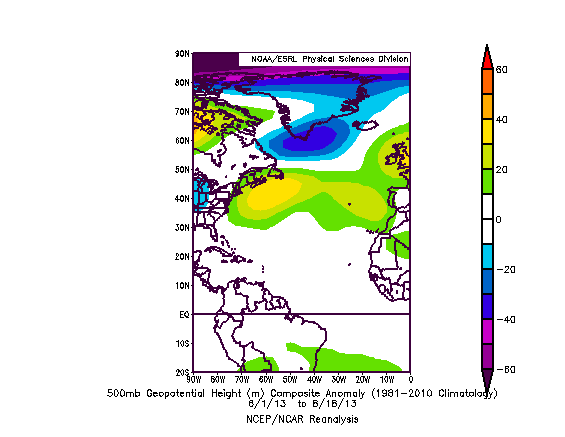
This summer has featured persistently warm waters off of the New England and Nova Scotia/Newfoundland coastlines, along with cooler waters off of the south coast of Greenland. The 500mb height anomalies have almost matched this configuration through the summer, with abnormally high heights from June 1 through mid-August off of the New England/southeastern Canada coastline, and lower than normal heights over the southern tip of Greenland. The question is, will this positive NAO pattern continue into winter?
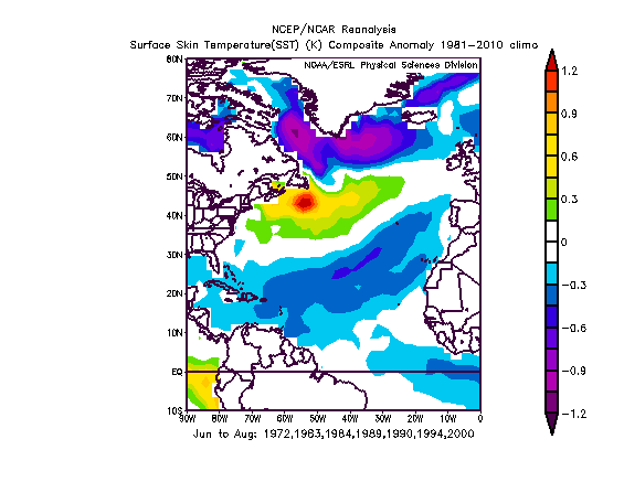
I have thumbed through all summers since 1949, seeking out other June-July-August periods that featured similar Atlantic sea surface temperature configurations…with emphasis on warmth over the NW Atlantic and cooler waters over southern Greenland…I also looked for summers that didn’t feature scorching waters in the equatorial Atlantic. Here is the mean SST anomalies from those JJA periods:
It turns out, when looking forward, that in most of those winters the warm anomaly off of the southeastern Canada coast went away when averaged out:
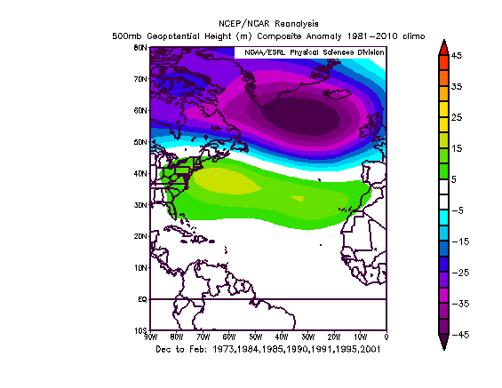
And for better or for worse, the mean 500mb height pattern over the Atlantic those winters featured a clear +NAO signal with eastern US ridging and lower than normal heights over much of the Northern Atlantic:
What is scary is a look at the Pacific and western North America 500mb height anomalies these winters is somewhat close to what I expect this winter, with ridging just off the western North American coast and trough over the central US, with perhaps some southeast ridging….although the above “Atlantic analog” years do not all match the “Indian Ocean/Pacific analog” years used earlier.
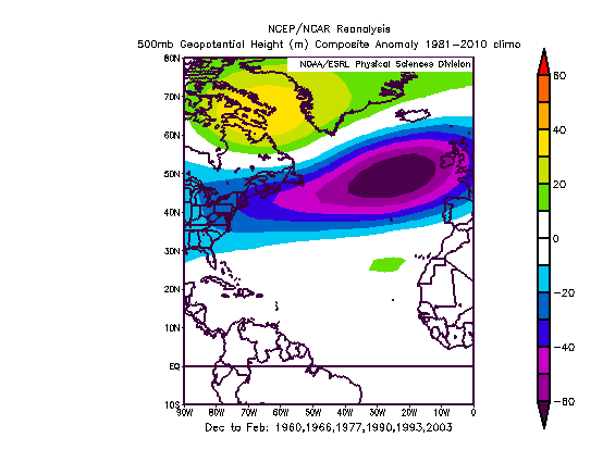
This year, the monthly NAO values have ranged from +0.5-+1.0 for each month April-August. When thumbing through monthly NAO values provided on NOAA’s Climate Prediction Center’s website (ftp://ftp.cpc.ncep.noaa.gov/wd52dg/data/indices/nao_index.tim) I found 6 years (since 1950) that had spring-summer NAOs that fairly closely resembled this year’s monthly values…and I had to get a bit generous with which years were included on the last at times just to get a data set larger than one or two years, evidently modestly but consistently positive monthly NAO values in spring-summer don’t happen often. The years found are: 1959, 1965, 1976, 1989, 1992, 2002. In those six years, four winters featured a predominantly negative NAO (1959, 1965, 1976, 2002) and two featured a predominantly positive NAO (1989 and 1992). Talk about conflicting data in more than one sense of the word! Here is a look at those winters from a level of about 500mb, on the mean:
As encouraging as this looks, the mean ENSO in these years was warm with a warm PDO…and well below normal waters off the coast of New England and southeastern Canada, which seems unlikely to occur this year. So, as encouraging as this may be for the eastern US, I’m not sure I’ll be giving it much weight.
Quasi-Biennial Oscillation:
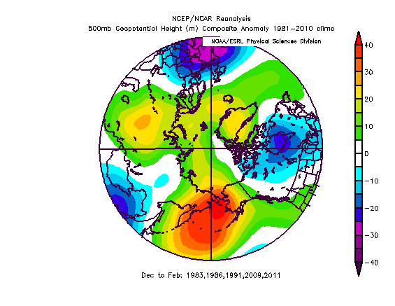
A look at the upper levels of the atmosphere over the tropics suggests that the zonal winds are blowing stronger than normal out of the west, and strengthening in the stratosphere. Lower level temperatures and winds (500/200mb respectively) have not responded drastically, but it appears as though the QBO will be positive or westerly this winter, and perhaps moderately so. Since 1979, per this data-set using the 30mb level as a proxy (http://www.cpc.ncep.noaa.gov/data/indices/qbo.u30.index), I have found 5 years that featured the QBO rising to fairly high positive values in the summer that persisted into winter…they are 1982, 1985, 1990, 2008, 2010. When the QBO is in a “negative” or easterly phase sudden stratospheric warming events and potentially severe blocking are more likely. When the QBO is in a “positive” or westerly phase sudden stratospheric warming events tend to be less likely. In the years above, here is a look at the winter time 500mb heights anomalies over the upper latitudes in the Northern Hemisphere:
There are signs of high latitude blocking, especially from eastern Siberia to Alaska (which I’m not sure I agree with based on the Pacific pattern discussed above) and signs of a modest –NAO…although they aren’t strong.
Years with similar summer patterns:
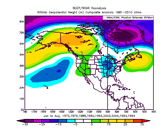
This summer (through mid-August) has featured positive height anomalies from Alaska east across northern Canada with lower than normal heights over southern Greenland…and above average heights off of the New England and southeastern Canada coastline. The western US has seen modestly higher than normal 500mb heights with modestly below normal heights over the Mississippi Valley and Great Lakes.
Looking over the North American summers since 1949, I found a few summers that matched enough of the above mentioned features for me to take a closer look. 1994 was the best match by a fair margin and was given extra weight. The 500mb height anomalies in those summers looked like this, not a terrible match:
The composite 500mb height anomalies for the following winters aren’t pretty across the whole US:
The mean SST anomalies from these winters featured a west-based El Nino, which appears unlikely this winter. There were some similarities in a mean cold PDO…similar Atlantic SST configuration…and not too far off Indian Ocean configuration. Although I won’t give the above composite a ton of weight, it may need to be watched a bit if the La Nina falls apart. At this time it appears unlikely, but it is still just August. Here is a look at the SST anomalies from those winters in the tropics:
Putting it all together:
Given everything discussed above, I feel fairly confident in ridging just off the west coast of the US and a trough over the Rockies and central US. I also feel fairly confident in a southeast ridge appearing at times with generally below average precipitation across the southern US from coast to coast due to a cool ENSO. I feel somewhat confident in the NAO averaging somewhat positive but not strongly so, which doesn’t bode particularly well for the east coast outside of New England.
There may be a sudden stratospheric warming event and a period of strong –AO blocking, however I don’t feel like the QBO supports this, which may result in a predominantly positive AO winter. The best shot at persistent high latitude blocking may be over the EPO region (Alaska/western Canada) where I feel like ridging will be most consistently impinging on the polar vortex. Given where I think trough is most likely across the central US a favored storm track may be from the central/southern Plains east/northeast towards the Great Lakes and New England…which may favor above average snow across the central/upper Mississippi Valley…central/upper Great Lakes…and inland New England. Areas like the Ohio Valley…lower Lakes…upper Mid-Atlantic and southern/coastal New England may see many messy storms and even some warmer/rainy storms.
Trends among sea surface temperatures worldwide and other factors such as fall snowcover will give us a better idea of what to expect as we head towards October and November, but here is a look at what I expect this winter across the US and southern Canada…on a mean for December-February. If time permits I will update this outlook as needed and add monthly maps in about two months. Thanks for reading!
My current thoughts on DJF temperatures:
Thoughts on DJF precip:
Based on my interpretation of the pattern, storm tracks that may be common:









Very nice outlook! Well reasoned, easy to follow and thorough research. I am curious as to your thoughts on snowfall in the Toronto/Southern ontario area? Thanks.
Thanks for the comment Adam! Right now I am expecting near average snowfall for the Toronto area. I think you guys may see some of the larger storms cut a bit too far northwest, meaning you would see rain/mixing issues. However, I’m sure that at some point during the winter we will see the pattern shift east enough or get enough of a -NAO for a time to shift the storm track to your south, so I do think you may see one or two 15cm+ snow events on top of any number of minor events or mixed precipitation events to work your way up close to average snowfall.
Pingback: Jim Sullivan’s 2014-2015 Winter Outlook for the US and Southern Canada | Ramblings of Freshman Met Student