
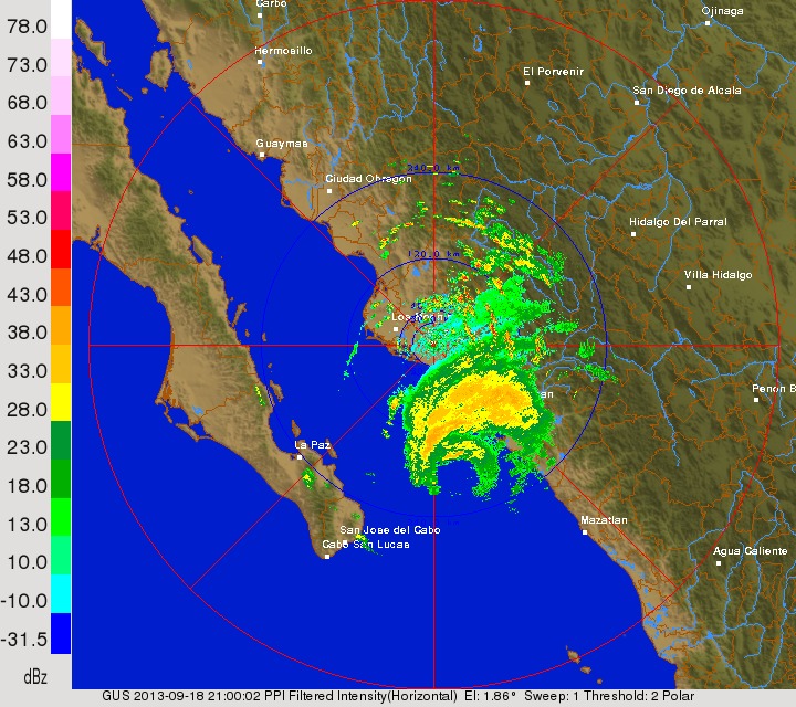
Woah! What’s that? It looks a lot like a hurricane not too far from Los Cabos and La Paz over the southern Gulf of California. Well, as of 2PM PDT it was a strong tropical storm, however it is close to becoming a hurricane. I didn’t talk much of Manuel yesterday because it looked like this would remain below hurricane status and drift west towards La Paz over the next few days. However events today have significantly changed that thinking.
Instead of drifting west and only slowly intensifying resurrected Manuel has been slowly drifting north and has a very impressive radar presentation, complete with a well formed eye and eyewall. This system is expected to become a hurricane later this evening. So, what has caused this sudden forecast change? First and foremost, the system became much stronger than normal. When looking at the upper level winds near Manuel, conditions are very favorable for development with winds in the upper levels of the atmosphere fanning away from Manuel. This is called an upper level anticyclone (or high pressure) and helps promote rising air beneath it and helps maintain low wind shear over the tropical storm:
This favorable upper level wind pattern existed yesterday however this rapid intensification didn’t begin occurring until this morning. In addition, most of our forecast models and the National Hurricane Center did not expect this rapid intensification to occur today. Why not? The NHC cited downsloping winds off of the mountains in mainland Mexico as a possible hindrance to intensification. Downsloping winds aren’t good for a tropical cyclone because they feed much drier air into the circulation and disrupt thunderstorm development. However, we still had very intense convection occur in and around Manuel’s circulation today, and as of this writing they aren’t showing any signs of dissipating. My theory is that because Manuel is a relatively small cyclone with its circulation really only grazing land that downsloping isn’t having much of a negative affect:
Note how the lower dew points over inland Mexico…in the 50’s and 60’s…have NOT filtered down to the coastline with dew points in the 70’s around Manuel. This is one possible explanation for why Manuel has over performed today. Manuel being stronger than expected appears to be tugging the tropical storm north, which is different than the more westerly track expect just this morning. Here’s why:
When looking at the flow between about 5,000-10,000 feet up in the atmosphere over the eastern Pacific…and this is the flow that steers weaker tropical storms, like Manuel was yesterday…one can see that Manuel is stuck in weak steering currents between two areas of high pressure (note the two areas of clockwise winds to the east and west of Manuel). It was expected that Manuel would remain in this area of weaker wind flows and sit over the southern Gulf of California for a couple of days before the high pressure to the west extended east and began steering Manuel towards the west in the general direction of La Paz. However Manuel has been moving due north or perhaps a tad bit east of due north today, which was not forecasted. Let’s look at other layers of the atmosphere:
When looking at the flow between about 5,000 feet above the ground to about 23,000 feet above the ground over the eastern Pacific we can see some subtle differences…most notably being a better defined trough over the Rockies. While not a huge difference, the fact that Manuel has become stronger and is now being steering by the flow farther aloft allows it to “feel” the trough to its north a bit better, causing the northward motion we’ve seen today. While at the end of the day the forecast track will only be off by 50-100 miles compared to yesterday, the Gulf of California is less than 150 miles wide at its widest, which basically means Manuel will have direct impacts on the mainland of Mexico now as opposed to Baja.
So the forecast for Manuel:
Continue to drift along the western coast of Mexico for the next 36 hours. The system may make landfall at anytime between tonight and Friday between Culiacan and Ahome. Even if the system does not make a classic landfall anywhere along this stretch of coast, winds may gust over hurricane force at times over the next couple of days. Heavy rains will also be likely. As we head towards Friday and Saturday high pressure is still expected to briefly build in from the north and begin turning Manuel to the west. From this point it may threaten Baja between Loreto and La Paz. Fortunately the area between those two cities is extremely sparsely populated.
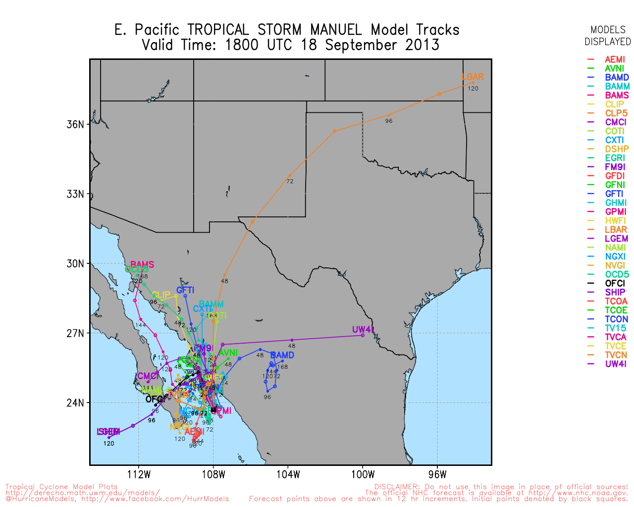
Manuel will likely become a hurricane this evening. Although the system is quickly intensifying as of this writing if it moves much closer to land the intensification will cease. Thus, I have a hard time forecasting anything stronger than a category 1 hurricane out of Manuel over the next couple of days. Most of our models show enough land interaction as Manuel moves up the increasingly narrow Gulf of California…and potentially some upwelling of cooler waters and Manuel constantly churns up the sea over the same area for the next few days…to significantly weaken Manuel by Saturday. This mucks up the track forecast somewhat over the weekend…as another trough is expected to dive into the western US. A stronger Manuel would likely be picked up by the trough while a weaker Manuel would likely continue to slowly drift near Baja. At this point we’ll again try to go with a weaker solution, causing Maneul to possibly make landfall on Baja this weekend as a weakening tropical storm that eventually dissipates. A look at our forecast track models for Manuel show how several different solutions are being portrayed by our various models:
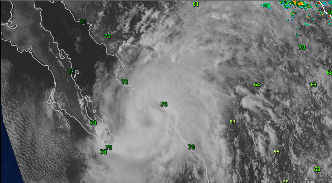
Elsewhere in the tropics we continue to monitor an area of low pressure that has recently emerged over the Bay of Campeche after spending some time over the Yucatan Peninsula. Shower and thunderstorm activity has begun to become more concentrated near this rather potent low pressure center and a tropical depression will likely form within the next 24 hours if this trend continues:
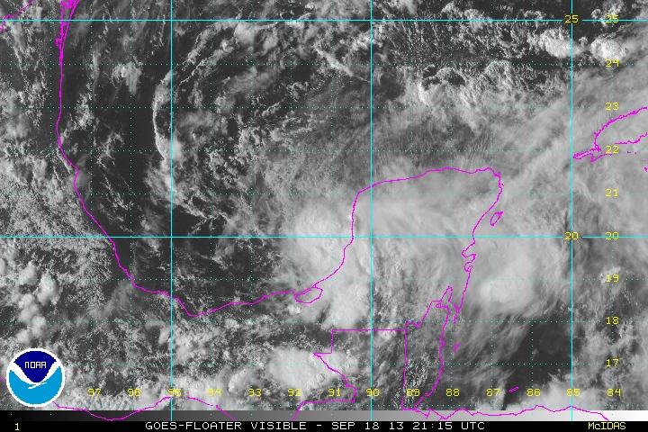
The center of circulation appears to be near the northern edge of the ball of convection on the above satellite imagery, due to some moderate northerly wind shear. As we discussed yesterday I expect shear to begin diminishing over this disturbance as an upper level anti-cyclone builds over it. This appears to favor a strengthening system over the next couple of days and we should have Tropical Storm Jerry in the southwestern Gulf of Mexico by the weekend.
From there the forecast remains highly uncertain as a trough over the central US possibly interacts with this area of low pressure. The models show the trough getting far enough south into the Gulf to pick up a stronger cyclone but leave behind the weaker one. You can see how borderline it is on this afternoon’s run of the National Weather Service’s GFS model:
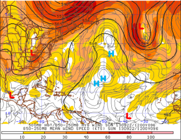
IF this system remains weak it may get left behind by the trough and either dissipate or make landfall in Mexico. A stronger system may get picked up by the trough and get sling shot towards the Northern Gulf Coast. I still favor a weaker system staying south and moving into Mexico Friday or Saturday however if this low pressure system becomes more robust…oh say like Manuel over the past day…there could be a threat to the Northern Gulf Coast. Continue to stay tuned as we monitor this disturbance.
