
The much anticipated blast of cold air is starting to arrive today across parts of the Plains, Midwest and Great Lakes, and will spill east into the Northeast to start the weekend. A bigger blast will arrive next week, and the potential appears to be growing for a swath of light to moderate snow accumulations across the Midwest and Great Lakes with a low pressure system that develops along the cold front associated with this blast of chilly air Monday into Tuesday:
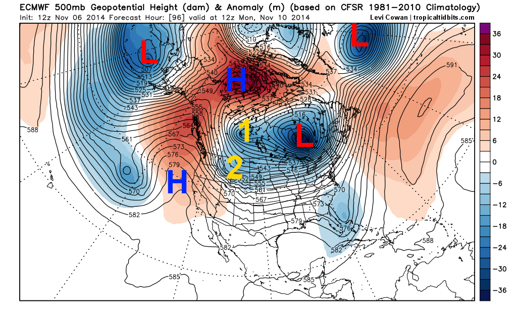
In this post I’m going to look at what this afternoon’s European model and its ensembles say about the pattern and possible storm. The first image shows the European model valid Monday morning, and is looking at the upper level weather pattern across the continent. As advertised, a large low pressure system (remants of a Super Typhoon) over the Bearing Sea is shown to cause a large upper level high pressure system to develop over the West Coast and north into far Northern Canada. This forces very cold air to plunge east into central Canada and eventually the central US next week. There are several features that will influence if and where a possible storm develops on the front edge of this cold air for Monday and Tuesday across the central US into the Great Lakes; the position of two upper lows, one near James Bay in this image and another south of Iceland, and the position of two pieces of energy (labelled 1 and 2) moving across the Rockies and dropping in from Canada on Monday.

The second image shows what the upper level pattern looks like Tuesday morning on the European model. The expansive high pressure over the western parts of the continent is causing the cold air to begin plunging into more of the central US by this point. Piece of energy number 1, which will bring the brunt of the cold, has moved into North Dakota by this point, and piece of energy number 2 is located just southeast of it. Because the European model moves the upper low near James Bay on Monday east far enough and shows “#1” diving into the US as far west as North Dakota, the southwesterly flow ahead of “#1” allows some warmer air to build farther north. This allows “#2”, which may spark our storm system, to track farther north. The resulting surface map for Tuesday morning is shown in the third image. Note how any snow is mainly confined to the upper Midwest and upper Great Lakes.

The European ensembles have a slightly different take on the situation in the fourth image, valid Tuesday morning. They drop #1 farther east, into Minnesota by Tuesday morning, which forces #2 and our possible storm to track farther southeast, which gives snow possibly as far south as Chicago and Detroit. Because #1 drops down farther east, the large upper low moving from James Bay to Nova Scotia between Monday and Tuesday mornings is close enough to #1 to prevent warm air from surging as far north ahead of it, which results in the farther south and colder solution. In general, the GFS agrees with the farther south and colder solution, and is even farther south than the European ensembles. The Canadian model is closer to the European model, and shows a more northern storm track.

So, we have a good range of solutions on the table for early next week’s possible snow in parts of the Midwest and Great Lakes, which is to be expected several days out. Although the European model and its ensembles are trying to develop a bit of a thumb ridge in the northern Atlantic towards Greenland, the NAO isn’t really negative, so a solution in which the storm occurs farther northwest isn’t impossible. At this point, the models are agreeing on a swath of snow somewhere in the Midwest into the Great Lakes Monday night and into Tuesday, and due to the models showing a stronger “#2” over the last day or so, I believe that the idea is gaining traction. However, where it occurs is uncertain. I’m inclined to go with the slightly farther south solution which may mean snow closer to Chicago and Detroit Monday night into Tuesday due to the upper level low near Iceland possibly helping to “block up” the pattern a bit and keep the upper level low over James Bay on Monday from moving east as fast, but with no true –NAO block (high pressure over Greenland), that’s no sure thing yet.
We will have updates on this possible Midwest and Great Lakes snow over the next few days, and will have a look at other impacts from the cold later next week and the pattern farther down the road either later tonight or tomorrow.
