
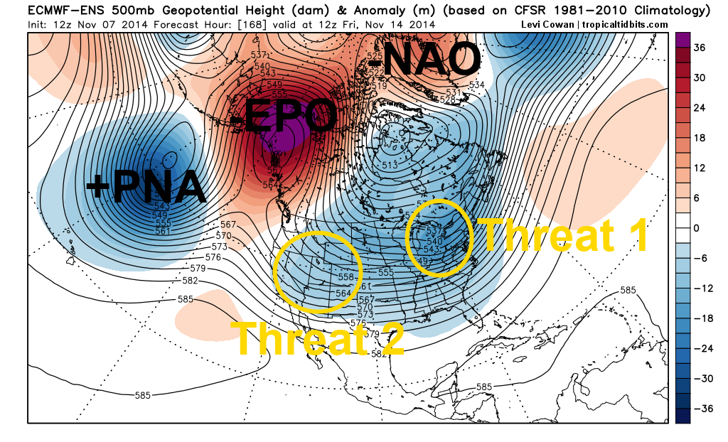
WOW. The first image, showing this Friday afternoon’s European ensemble upper level weather pattern (500mb level) for next Friday is a classic cold pattern with extreme “blocking” in the high latitudes. A low south of the Aleutian Islands is pumping up a ridge of high pressure on the West Coast, called a “+PNA,” and that high pressure extends extremely far north, and consequently causes the “EPO” to become negative. In addition, some ridging is also developing over Greenland, which is beginning to turn the “NAO” negative by the end of the week. All of this “blocking” of the jet stream in the high latitudes causes the jet stream to plunge south well into the central and eastern US, causing unseasonably cold air to flood the eastern 2/3rds of the country for the second half of this upcoming week and into next weekend.
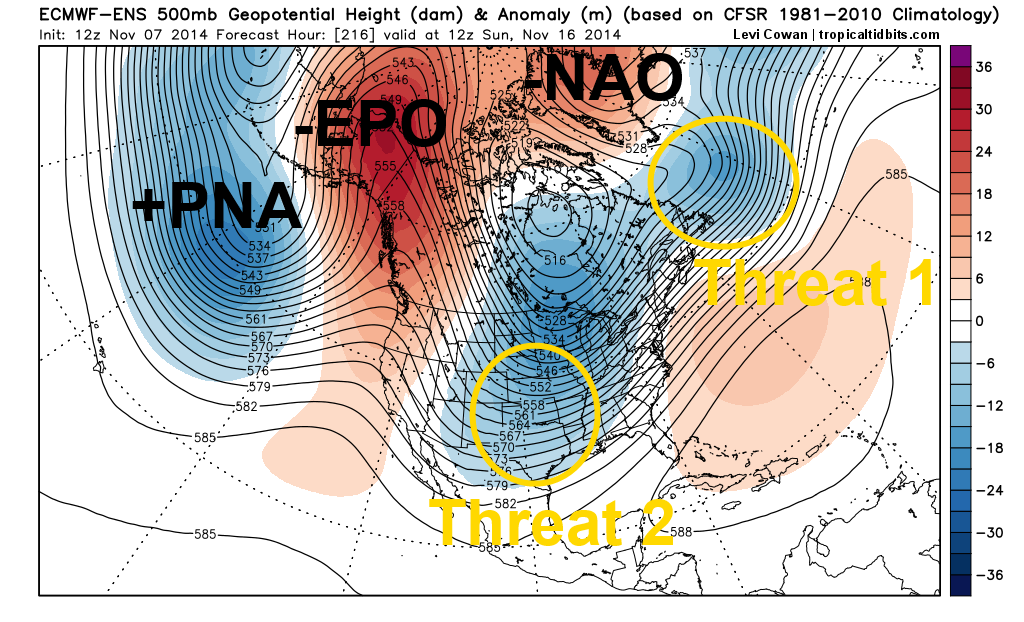
This pattern is also one that may produce snow over the eastern US late this week into next weekend, IF certain pieces fall into line. On the first image, there are two ripples in the jet stream that I keyed in on. The first one is located over the eastern Great Lakes Friday morning, and the second one is over the southwestern US. On the second image, valid Sunday morning, you can see that strong high latitude blocking is persisting, and the second ripple in the jet stream is rounding the base of the trough in the central US, and getting ready to move northeast.
Our “deterministic” models, the GFS, Canadian, and Euro, have shown some snow potential with both of these ripples off and on, but in general have been all over the place. Considering this is all over a week out, that’s not a huge shock. However, the signal on the ensembles (shown in these images) and the overall pattern is interesting. The question with wave one, in my opinion, is will it be robust enough to develop a strong storm over the Eastern US on its own? Even though there is a lot of high latitude blocking to force the cold into the central and eastern US, the trough looks pretty “broad,” and there is no “50/50 low” over the Nova Scotia/Newfoundland at this point, which results in the flow over the eastern US and northwest Atlantic being very fast on Friday. This argues against a strong storm developing from “threat 1.” However, we will have to monitor the potential for some snow across the northern Mid Atlantic or New England from “threat 1” for Thursday or Friday if the ripple in the jet stream is more robust, and is able to develop a strong storm without being forced to slow down due to the lack of a 50/50 low.
The second threat may have a bit more room to work with. If “threat 1” is able to intensify either over the Northeast or after it moves off the East Coast, it may act as our 50/50 low for the latter portions of next weekend, which is a more favorable look for snow over the eastern US. In addition, note how the trough with all of the cold over the central US is much “sharper” looking in the second image, which is a more favorable look for a bigger storm developing. Where exactly the second storm tracks if it develops is uncertain, because there will be a bit of a “Southeast Ridge” in place, however the pattern appears to be generally favorable for any possible storm that develops with “threat 2” around Sunday November 16th to produce snow somewhere over the Eastern US (whether that occurs closer to the coast or a bit farther west is unknown).
The models agree on lots of cold this week, but then become very messy when trying to pick out a possible storm and threat for snow later in the week and into next weekend. The evolution of the pattern looks interesting however, especially for threat 2 around November 16. Threat 1 seems a little less likely to occur, but I still wouldn’t completely write it off over the far northern Mid Atlantic and parts of New England quite yet.
