

A large corridor of winter storm watches and warnings and winter weather advisories has been issued from Montana and the higher elevations of Wyoming east across parts of South Dakota, North Dakota, central and southern Minnesota into northern Wisconsin and much of the Upper Peninsula of Michigan for a swath of moderate to heavy snow that is expected to fall starting on Sunday in Montana and Monday night in areas as far east as Michigan, and last through Tuesday in the Upper Peninsula of Michigan.
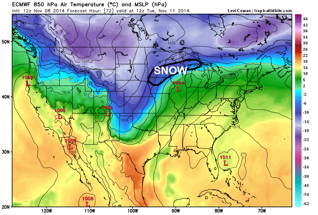
This swath of snow will be caused by an area of low pressure tracking from the central Plains northeast into central Michigan along an arctic frontal boundary pushing south into the central US. The Euro shows this low gaining steam in the Plains on Monday morning:

Note the extremely strong temperature gradient from one side of the low to another, which will contribute to favorable mid-level “frontogenesis” along the low track, which is a source of lift that may cause a fairly prolonged period of moderate to heavy snow in some areas.
By the time we hit Tuesday morning, the low pressure has weakened some, however it still has a pretty strong temperature gradient along the front to work with, and is still expected to be producing a good amount of snow on the north side of the low track:
In addition to lift along the front as warm, moist air from the south gets lifted over the cold air in the low levels of the atmosphere to the north of the low pressure track, there will also be good lift from a “jet streak” within the jet stream. This image from this evening’s NAM run shows wind racing away from parts of Wisconsin and Michigan, which forces air to rise from below to replace the air rushing away, which is another source of lift for possible heavy snow:

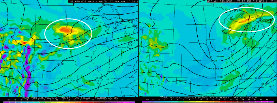
In addition, on the below image, also from this evening’s NAM run, you can see strong lift in the mid-levels of the atmosphere on Monday morning in the left image and Tuesday morning in the right image. You can cross reference this to the Euro model images above, and see that the area of lift in the mid-levels matches the temperature gradient pretty well (it occurs a bit farther north on this model because it is slightly farther north with the low track, and also because this is a higher level ~10,000 feet vs ~5,000 feet in the atmosphere than shown in the Euro temperature maps above):
This all adds up to a period of moderate to heavy snow over a pretty decent swath of real-estate across the north-central US Sunday night through Tuesday as this low pressure goes by. A swath of 6-12” snow amounts look likely in the hardest hit areas, and locally higher amounts in excess of 15” aren’t impossible, especially if the storm is slightly stronger like the NAM shows, so this will be a pretty significant first major snowstorm of the season for these areas.
Here are NOAA’s Weather Prediction Center snowfall probabilities from Sunday evening through Monday evening:

Here are the snowfall probabilities for Monday evening through Tuesday evening:

Get ready in these areas for the first major snowstorm of the season! Stay tuned over the next couple of days for more looks at a possible eastern US snow threat late this week into the weekend.
-Jim
