
Brief description:
We are still a couple days away from any potential event and some things may change, however this type of scenario has been shown consistently since Friday night in most of our forecast computer models, which gives me decent confidence something like this will play out.
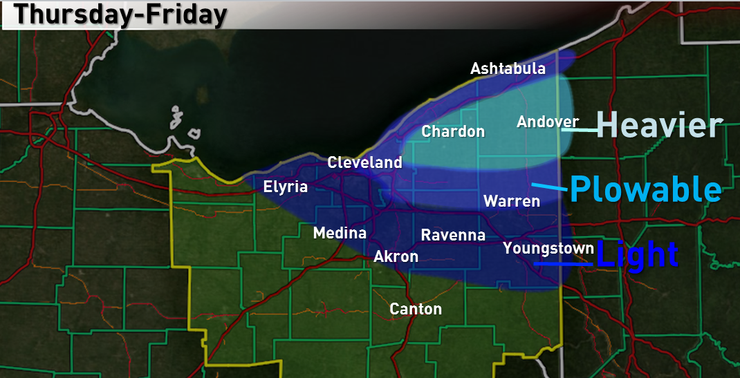
A few lake effect rain/snow showers may occur on Wednesday east of Cleveland with no accumulations. A few lake effect snow showers may occur Wednesday night east of Cleveland with accumulations of less than half an inch. The snow showers through Wednesday night will be light due to a dry atmosphere. On Thursday, a disturbance will begin approaching the region, increasing moisture levels and also making the atmosphere more unstable over Lake Erie, resulting in an increase in snow shower intensity. Conditions then look favorable for good lake effect snows through Thursday night and into Friday. It looks increasingly likely that a band of heavier snow will develop on Thursday across northeastern Cuyahoga County east into southern Lake, much of Geauga and a good portion of Ashtabula Counties. This band will likely sag south into more of Cuyahoga County and Trumbull County Thursday night before the lake effect gradually becomes a bit more disorganized by Friday morning due to a shift in the wind direction. Light to moderate lake effect snow may persist on Friday across southern and eastern Cuyahoga County east into Geauga, inland Ashtabula and northern Trumbull Counties. At some point, some lighter snow showers may also affect parts of Lorain, northern Medina, most of Summit, most of Portage and most of Mahoning Counties Thursday night into Friday. If a heavy snow band develops on Thursday, the Thursday PM commute would be rough on the east side. The Friday AM commute may also be affected to an extent.
If a good band of snow sets up like I think is becoming a better bet to happen, accumulations from eastern Cuyahoga County east into the Snowbelt in excess of 6” may be possible, especially north of US 422 and along and east of I-271. Outside of this area, “plowable” amounts of a couple inches or so look possible, with amounts then quickly dropping off to little to none farther south and west.
Technical Discussion:
Although cold air flows in on Wednesday with a westerly flow, limited moisture and low equilibrium levels will prohibit any lake effect of consequence through Wednesday night. It will be cold enough for any snow that does fall to perhaps produce a dusting in the primary Snowbelt Wednesday night with 850mb temps falling to -10C by Thursday morning and overnight lows below freezing for most anyone away from Lake Erie.
It gets more interesting on Thursday as a shortwave begins approaching, which will increase the moisture in the low levels of the atmosphere and also increase convergence across the snowbelt, possibly focusing a good band of snow. With 850mb temps of -10 to -12C on Thursday, and 700mb temps falling to around -20C by Thursday afternoon, lake induced instability will be moderate to extreme (lake temps of around 11C/52F), with BUFKIT spitting out around 700 J/KG of lake induced CAPE Thursday afternoon through early Friday. In addition, speed and directional shear over the lake look very minimal Thursday through the first half of Friday. With equilibrium levels pushing 10k feet for most of this time period and high RH air extending to varying levels, but typically at least 5,000 feet above ground level and at times up to 10,000 feet above ground level, there will be sufficient depth to the moisture and instability for heavy snow, especially if a good convergence/primary band can develop Thursday into Thursday night on the east side of Cleveland into the primary snowbelt.
Equilibrium levels and moisture depth slowly degrade on Friday, but at least light to moderate snow showers could continue for a good chunk of the day mainly in the eastern suburbs into the primary snowbelt.
The models are all in pretty good agreement in showing a shortwave trough passing overhead Thursday evening, with a surface trough also dropping across the lake at some point Thursday night with a wind shift from more westerly on Thursday to more WNW or even NW for a time Friday morning. Winds will be mainly WNW on Friday as ridging begins building in from the southwest. Shortwaves are often good for an increase in lake effect snow intensity due to the fact that they often bring an increase in moisture, cooler mid-level temperatures (more instability over the lake), and often a brief shot of large scale lift. In addition, in my disorganized research and tedious observations over the last several years, I have found that a convergence/primary band is most likely to develop over the central lakeshore east into the primary snowbelt in a W or WNW flow ahead of a surface trough, until the trough begins pushing inland from the lake. This is due to subtle pressure falls ahead of the surface trough resulting in winds backing ahead of it, in addition to the pull of friction over land resulting in slightly more backed surface winds. Over the lake, winds at the top of the boundary layer often have a more northerly component, and these winds mix down to the surface over the lake due to the instability over the lake and lack of friction over the lake. This results in more northerly winds over the lake running into winds that are more backed over land, causing convergence near the lakeshore. This is maximized with a W to WNW flow for the central lakeshore east into the primary snowbelt due to that flow paralleling the western and central lakeshore in northern Ohio.
Regardless, the shortwave approaching is a good sign for an organized band developing on Thursday. With a due west or slightly north of due west wind ahead of the shortwave, any band would likely affect northeastern Cuyahoga County (just east of Cleveland east into the eastern suburbs north of US 422) east into Geauga, southern Lake, Ashtabula and perhaps northern Trumbull Counties. This band may persist for several hours Thursday into Thursday night. As the trough pushes inland at some point Thursday night, the band would sag southwest before gradually weakening. Convergence may increase for a time Friday afternoon across the primary snowbelt as higher pressure builds in from the southwest, however lake effect conditions will be a bit more marginal by this point. With pretty good lake effect parameters, heavy snow would be likely at times in any band. With surface temps near freezing during the day Thursday and below freezing by a little bit at night, and 850mb temps of colder than -10C, accumulating snows would be extremely likely under any banding during the day and at night inland, and possible down to the lake if good snow rates can be sustained there. Given the potential duration of the band (12 hours from Thursday morning through Thursday evening as it looks now, before sagging south/weakening later Thursday night), and possibly heavy rates beneath it, a corridor of 6”+ of snow is a possibility from eastern Cuyahoga County east into the primary snowbelt. Lesser amounts will occur farther south and west as the band sags south and weakens later Thursday night. Light to moderate, but likely more disorganized snow showers continuing on Friday may add light amounts in the primary snowbelt.
Preliminary look at parameters, via the NAM in BUFKIT (the GFS isn’t much different):
18z Thursday/1PM EDT:
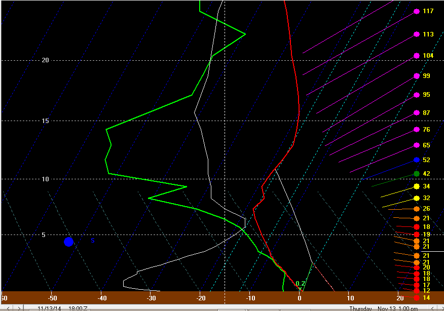
Moderate lake induced instability, with EL’s surpassing 10k feet. Moisture is still a bit limited, but probably wouldn’t be prohibitive if a good band develops. Note the well aligned west to slightly north of due west flow below about 7.5k feet. Winds speeds also aren’t too strong, which is good.
0z Friday/7PM Thursday EDT:
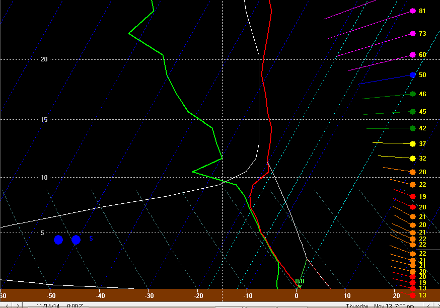
Extreme lake induced instability, with EL’s still hanging just above 10k feet. Good moisture as well to about 9k feet, with winds still well aligned and not prohibitively strong. This would support moderate to heavy snow in any band.
6z Friday/1AM EDT:
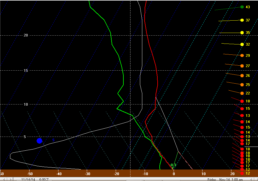
Moderate lake induced instability, with good moisture to about 7k feet still. The winds are still very well aligned and not very strong, but have gained a bit of a northerly component, suggesting any band shifting a bit farther southwest at this point.
12z Friday/7AM EDT:
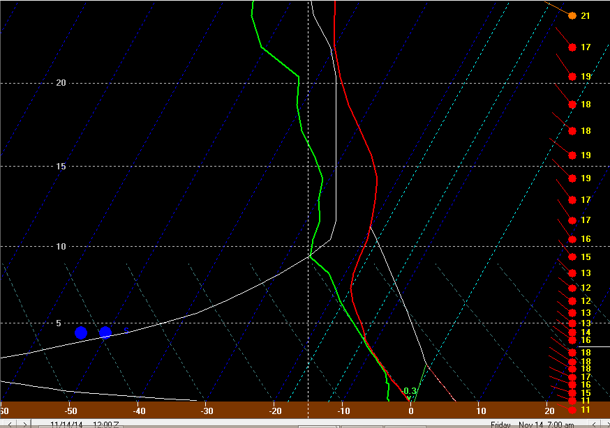
Extreme lake induced instability, with good moisture still to 7-8k feet. Winds not quite as well aligned and have gained a slightly stronger northerly component, which may cause any band to possibly weaken by Friday morning. In general though, this is still a decent lake effect snow sounding for the eastern suburbs and primary Snowbelt.
We’ll see how this plays out over the next couple of days and if there are any changes.
Jim
